A mountain can rise so slowly that no person notices it in a lifetime, while a hillside can collapse in minutes. That contrast is one of the most amazing ideas in Earth science: Earth's surface is always changing, but the changes happen at very different speeds and across very different areas. To understand those changes, scientists do more than describe what they see. They construct explanations based on evidence. That means they look at clues in rocks, landforms, sediments, and measurements, then explain what process most likely caused the change.
Earth does not have a fixed outer shell that stays the same forever. Continents shift, valleys deepen, coastlines move, and new rock can form while old rock breaks apart. Some processes act mainly at the surface, such as moving water, wind, ice, and gravity. Other processes begin deep inside Earth and affect the surface from below, such as plate movement and the rise of magma.
When scientists study these changes, they ask two important questions: How long did it take? and How large an area changed? These are questions about time scale and spatial scale. A surface change might happen quickly in one valley, or slowly across an entire ocean basin. Understanding both kinds of scale helps us make better explanations.
Earth's surface is shaped by a balance of constructive processes, which build up land, and destructive processes, which wear it down or break it apart. For example, lava cooling into rock can add new material to the surface, while erosion can remove rock and soil from one place and carry it elsewhere.
These changes are part of a larger Earth system. The atmosphere, hydrosphere, geosphere, and biosphere interact constantly. Rain falls from the atmosphere, flows across the geosphere, may freeze in the hydrosphere, and affects living things in the biosphere. Because Earth's systems interact, one change can trigger another. A long period of rain can loosen soil, and then gravity can pull that soil downhill in a landslide.
Geoscience process means any natural process that shapes Earth's materials or surface. Examples include weathering, erosion, deposition, volcanic activity, plate motion, and the movement of water, wind, and ice.
Evidence is the information scientists use to support an explanation. In Earth science, evidence can include rock layers, sediment size, the shape of landforms, maps, photographs, and measurements collected over time.
Even though many processes work together, scientists can still build strong explanations by matching evidence to the process that best fits it. A wide, curved valley with scratches on rock suggests moving ice. A delta built where a river enters a larger body of water suggests that flowing water carried sediment and then dropped it when the water slowed down.
Geoscientists often cannot watch a whole landscape change from beginning to end, especially when the process takes thousands or millions of years. Instead, they study clues left behind. These clues include landforms, sediment deposits, rock layers, faults, and the sizes and shapes of particles.
A river provides a good example. Near its source, the water may move quickly and carry larger pieces of rock. Farther downstream, the water usually carries smaller particles because larger pieces were dropped earlier. If scientists observe rounded pebbles in one location and fine mud in another, they can use that evidence to explain how the river transported and deposited sediment.
Modern technology adds even more evidence. Satellites, drones, and GPS measurements let scientists compare the same place over time. If a coastline slowly moves inland, repeated images can show that erosion is removing land. If the ground rises in a region over many years, that pattern may support an explanation involving movement below Earth's surface.
Remember that a scientific explanation is not just a guess. It connects a claim to specific evidence and then uses reasoning to show why the evidence supports the claim.
Evidence matters because different processes can sometimes create landforms that seem similar at first. A steep slope may result from river erosion, uplift, weathering, or gravity-driven movement. Looking at only one clue can be misleading. Looking at several clues together usually leads to a stronger explanation.
Most geoscience processes are powered by two main energy sources, as [Figure 1] shows: energy from the sun and energy from Earth's interior. The sun drives weather and the water cycle. Earth's internal heat helps drive the movement of material inside the planet, which leads to plate motion.
Solar energy causes evaporation, and water later returns as precipitation. That moving water can weather rock, erode soil, and transport sediment. Wind also depends on uneven heating by the sun. So when you see sand dunes, stream channels, or worn rock surfaces, the ultimate energy source is often the sun.
Energy from inside Earth comes from heat left from Earth's formation and from radioactive decay inside the planet. This internal energy causes slow movement in the mantle. Those movements help push and pull tectonic plates. Over time, plate motion can form mountains, open rift valleys, and build new crust. The connection between deep Earth energy and Earth's surface features is a fundamental concept in Earth science.
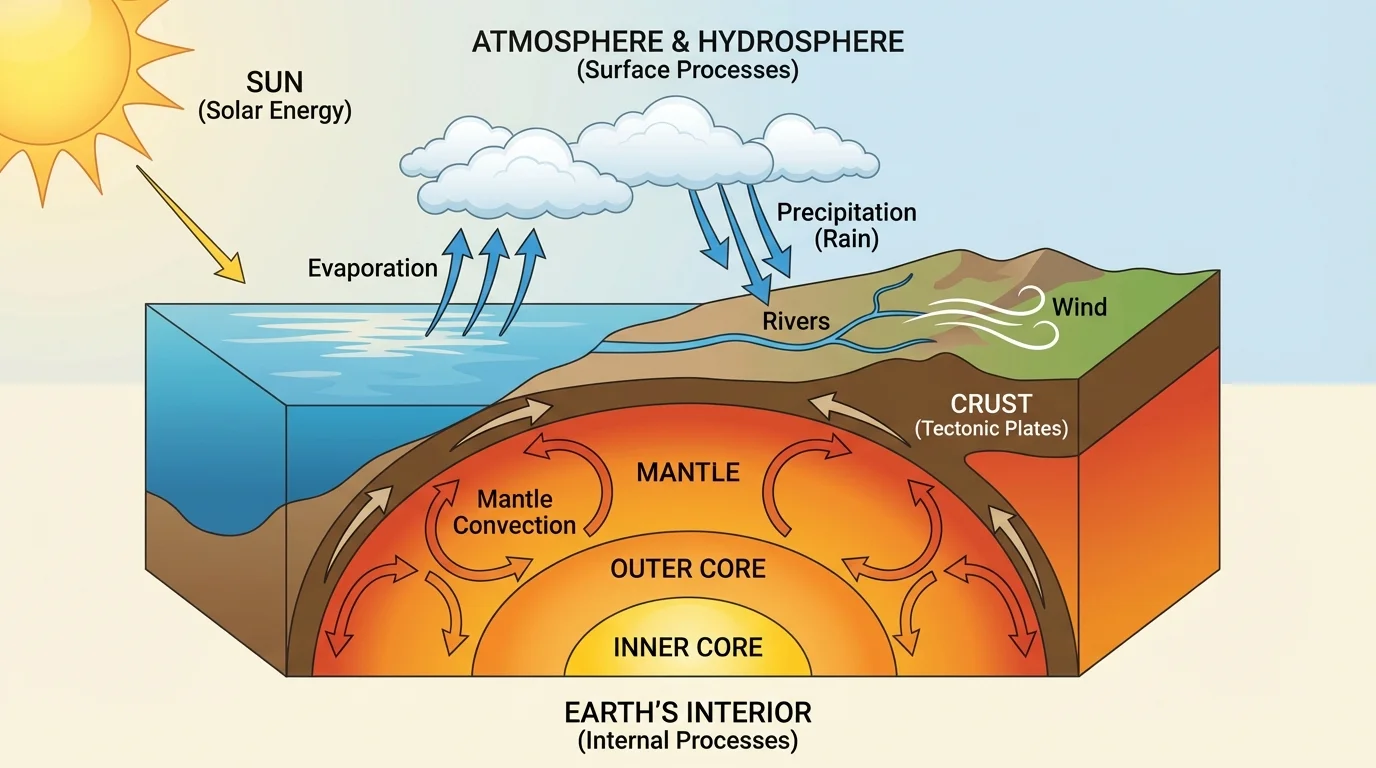
You can think of Earth as a planet shaped from both the outside and the inside. Surface agents such as rain and rivers often wear land down, while internal forces can lift land up. Landscapes are the result of this long competition between building and wearing away.
The same hill can be affected by both energy sources at once: internal forces may slowly lift the land upward while rainwater and streams remove material from the surface.
Later, when we compare short-term and long-term changes, the pattern in [Figure 1] remains important because it explains why very different-looking processes can still be connected through energy flow.
Some geoscience processes act so slowly that their effects are visible only after many years, while others can change the land in a very short time. Weathering can slowly break rock into smaller pieces. Plant roots may widen cracks little by little. Water freezing in cracks can also split rock apart over repeated cycles.
By contrast, a flood can quickly reshape a stream bank, and a landslide can move huge amounts of rock and soil downhill in minutes. The key idea is not that one kind of process is more important than another. The key idea is that explanations must match the scale of the evidence. A deep canyon most likely formed through long-term change, while a fresh scar on a slope may point to rapid movement.
Slow changes are often easier to miss in everyday life, but they can be enormous over long periods. If a coastline erodes by only a small amount each year, the total change after many years can be large. For example, a retreat rate of about \(0.2 \textrm{ m/year}\) would become \(2 \textrm{ m}\) in \(10\) years because \(0.2 \times 10 = 2\).
Scientists often compare rates of change to understand these differences. A process with a small rate can still have major effects if it continues for a long time. That is why both speed and duration matter in explanations.
[Figure 2] Plate tectonics explains many of Earth's largest surface features. Earth's outer shell is broken into plates that move very slowly. Where plates interact at their boundaries, they can collide, separate, or slide past one another.
When plates push together, the crust can crumple and thicken, helping build mountain ranges. In some places, one plate sinks beneath another. This can lead to melting and the movement of magma, which may create volcanic landforms. When plates move apart, material from below can rise and harden, forming new crust. When plates slide past each other, stress can build and then be released, sometimes causing sudden changes in the ground.
These processes usually act over very large areas and long periods of time. They can shape continents and ocean floors. That is why plate tectonics is often linked to regional or global spatial scales. However, some effects, such as surface rupture or uplift, may be noticed more locally.
The evidence for plate-related surface change includes folded rock layers, faults, mountain belts, volcanic rock, and measurements showing that land is moving. Scientists combine these observations to explain how deep internal energy causes large-scale changes at the surface.
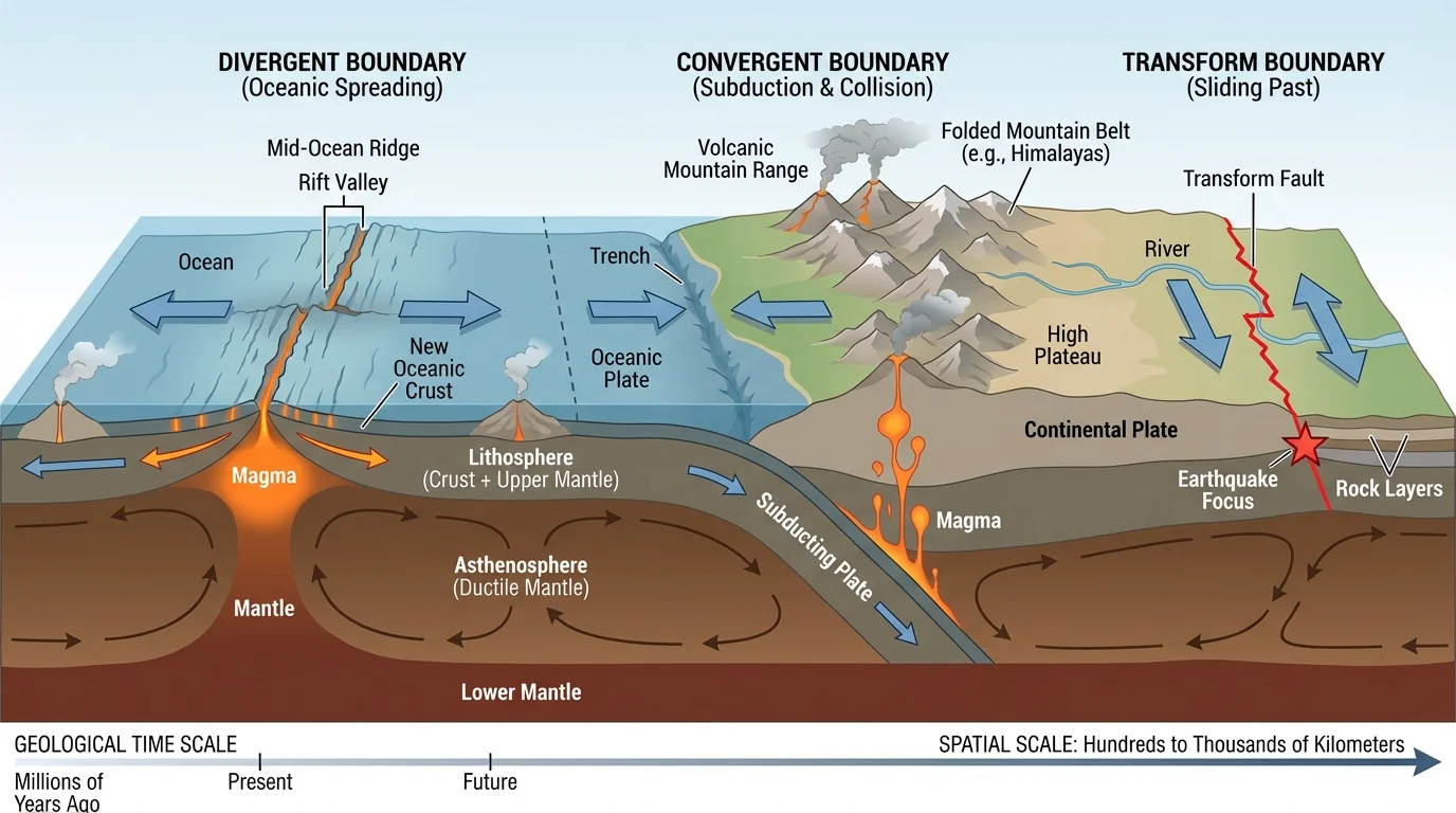
Large-scale changes do not mean quick changes. Plate movement is usually extremely slow, yet the total effect over millions of years is dramatic. The landforms associated with plate tectonics remind us that a very slow process can still reshape huge parts of Earth.
Why plate tectonics matters
Plate tectonics connects Earth's interior to Earth's surface. Without it, many major features of the planet would be hard to explain, including mountain building, the creation of new crust, and the shifting positions of large landmasses over time.
When students compare local erosion with mountain building, [Figure 2] helps show why some surface changes start deep below the crust rather than at the surface.
[Figure 3] At Earth's surface, some of the most powerful change agents are moving water, wind, ice, and gravity. These processes often work by erosion, transport, and deposition. Sediment is removed from one place, carried, and then dropped in another place.
Flowing water is especially important because it is common and persistent. Rivers and streams can cut channels, carve valleys, and move sediment from mountains to plains. Fast-moving water can carry larger particles. When water slows down, it loses energy and drops some of its sediment. Over time, this creates features such as floodplains, sandbars, and deltas.
Wind can also move sediment, especially in dry places with loose sand. It can wear rock surfaces and build dunes. Ice in glaciers can scrape rock, pluck pieces of it away, and transport large amounts of sediment. Gravity acts everywhere and can pull weathered material downhill, causing rockfalls, landslides, and soil creep.
The important idea is that material cycles through Earth's systems. Rock can be broken into sediment, carried by water, frozen into ice, dropped elsewhere, and later become rock again. Matter is not simply disappearing; it is being moved and transformed.
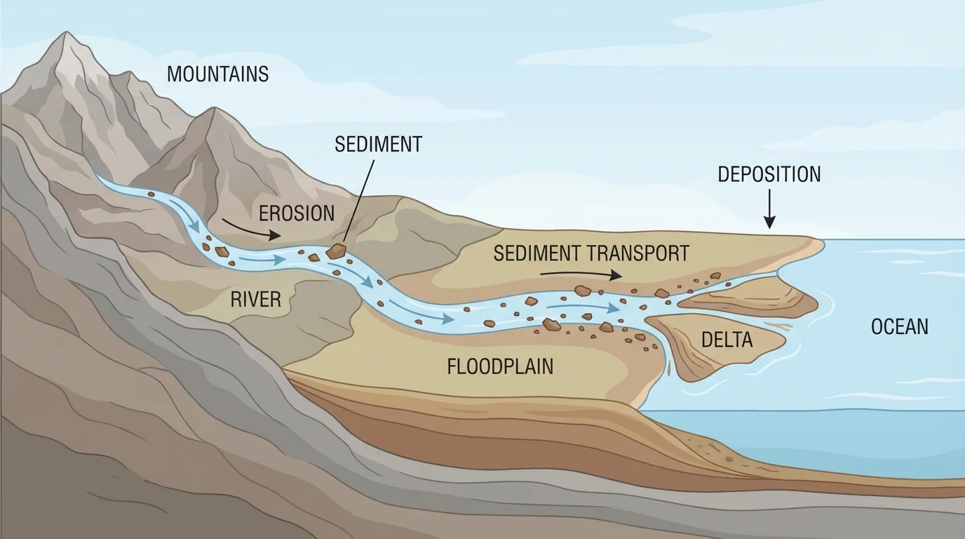
When scientists explain a landform, they often ask where the material came from and where it ended up. A sandy beach, for example, may be made of sediment eroded from cliffs or carried by rivers from inland areas. That makes the beach evidence of transport as well as deposition.
| Process | Main action | Typical evidence | Common scale |
|---|---|---|---|
| Weathering | Breaks rock apart | Cracks, smaller fragments, altered surfaces | Local, often slow |
| Erosion | Removes material | Channels, worn slopes, missing soil | Local to regional |
| Deposition | Drops material | Deltas, sandbars, layered sediments | Local to regional |
| Glacial movement | Scrapes and transports | U-shaped valleys, scratches, mixed sediment | Regional |
| Gravity-driven movement | Moves material downhill | Landslide debris, slope scars | Local, sometimes rapid |
Table 1. Comparison of several surface processes, the evidence they leave behind, and the scales at which they commonly operate.
As students trace sediment from source to destination, [Figure 3] makes it easier to see that one landscape may record several linked processes instead of only one.
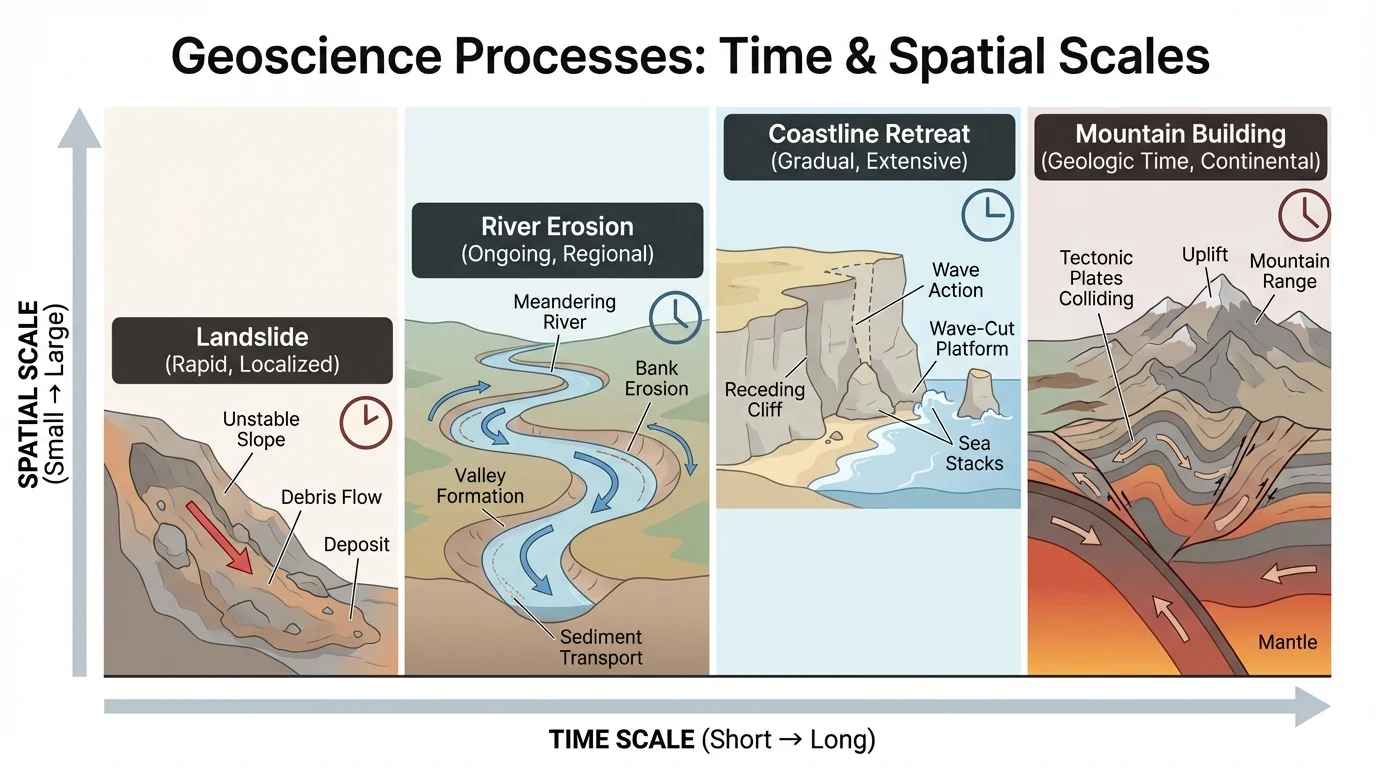
[Figure 4] Time scale tells how long a process takes, and spatial scale tells how large an area is affected. These two ideas help scientists compare different kinds of surface change.
A rockfall may affect a small area very quickly. River erosion may affect a valley over years to centuries. Plate motion may affect a continent over millions of years. None of these processes is "better" or "stronger" in every situation; they simply operate at different scales.
Thinking about scale helps prevent weak explanations. If a student sees a tiny crack in a sidewalk, it would not make sense to explain it with a continent-sized process. If a student sees a giant mountain range, it would not make sense to explain it only by a single rainstorm. Good explanations fit both the evidence and the scale.
Scale also helps scientists compare rates. Suppose one cliff erodes at \(0.5 \textrm{ m/year}\) and another erodes at \(0.1 \textrm{ m/year}\). After \(20\) years, the first cliff changes by \(0.5 \times 20 = 10 \textrm{ m}\), while the second changes by \(0.1 \times 20 = 2 \textrm{ m}\). Even simple calculations can strengthen an explanation by showing how change adds up over time.
Using evidence and scale together
A student notices a wide valley with smooth sides, loose sediment, and scratches on exposed rock.
Step 1: Identify the evidence.
The evidence includes valley shape, rock scratches, and transported sediment.
Step 2: Match the evidence to a process.
Moving ice can scrape rock, widen valleys, and transport sediment.
Step 3: Check the scale.
A valley this large forms over a long time and across a broad area, which fits glacial movement better than a short, local event.
A strong explanation is that ice reshaped the valley over a long time by erosion and transport.
Later, when comparing human planning decisions, [Figure 4] remains useful because the same process may matter differently depending on whether you are studying one hillside or an entire region.
Constructing an explanation in Earth science often follows three parts: claim, evidence, and reasoning. The claim states what process changed the surface. The evidence gives the observations. The reasoning explains why those observations fit that process better than other possibilities.
For example, suppose a coastline has steep, broken edges, fallen material at the base, and measurements showing that the shoreline has moved inland over time. A possible claim is that erosion and gravity are causing the coastline to retreat. The evidence includes the fallen material, cliff shape, and repeated measurements. The reasoning is that waves remove support from the base while gravity pulls loosened material downward.
A stronger explanation usually includes more than one piece of evidence. It also uses science ideas about energy and matter. Water carries sediment because it is moving. Gravity pulls material downhill. Plate motion changes land because internal energy causes movement below the surface. Good reasoning links evidence to these underlying causes.
Claim-evidence-reasoning model
Question: Why is a river delta growing at the mouth of a river?
Step 1: Claim
The delta is growing because the river is depositing sediment where it slows down.
Step 2: Evidence
There are layers of fine sediment near the river mouth, the water spreads out and slows, and the land extends farther into the larger body of water over time.
Step 3: Reasoning
When moving water loses speed, it has less energy to carry sediment, so particles settle out and build new land.
This explanation connects observation to process instead of only naming what the landform is.
Notice that the explanation does not depend on naming a famous place or a specific event. What matters is matching general evidence to a scientific process.
Understanding surface change is not only about studying nature. It also helps people make decisions. Engineers need to know whether a slope may fail. Farmers need to understand how erosion can remove fertile soil. City planners need to know where flooding or coastal retreat may affect roads and buildings.
Water supply is another example. Rivers, groundwater, and reservoirs are affected by weathering, erosion, and deposition. If too much sediment enters a reservoir, it can reduce storage space. If land is stripped of vegetation, runoff may increase and carry more sediment into streams.
Hazard planning also depends on geoscience explanations. If evidence shows that a slope has moved before, communities may avoid building there. If satellite measurements show slow ground uplift or sinking, scientists and planners can monitor those changes and reduce risk.
Scientists sometimes compare old photographs with new satellite images to measure surface change. A landscape can look "the same" to the eye but still shift noticeably when precise images are compared over many years.
The ideas from [Figure 1] and [Figure 3] are especially useful in real-world planning because they connect energy, movement of matter, and visible land changes.
Most landscapes are shaped by several processes, not just one. A mountain region may be lifted by plate movement, broken down by weathering, cut by rivers, and changed by gravity-driven slope movement. A coastline may be built by deposition in one place and worn away by erosion in another.
This is why scientists look for patterns. Are sediments getting smaller downstream? Are slopes steepening? Are rock layers bent or broken? Are repeated measurements showing motion? Patterns across different kinds of evidence often produce the strongest explanations.
Earth's surface is the result of energy flowing and matter cycling through Earth's systems. The sun powers wind, weather, and the water cycle. Earth's interior powers plate tectonics. Together, these energy sources drive the processes that build, break, move, and reshape the land around us.