A mountain range can rise over millions of years, an ocean can open and widen, and a continent can slowly drift thousands of kilometers without anyone noticing in a single human lifetime. That sounds impossible until you realize that Earth's surface is not one unbroken shell. It is broken into moving pieces, and that movement explains an enormous range of geologic events. Plate tectonics is the theory that ties these events together, making sense of earthquakes, volcanoes, mountain building, the age of the ocean floor, and even where continents were in the distant past.
Before plate tectonics, geologists could describe many features of Earth, but they lacked a powerful unifying explanation for why those features formed and changed. Today, plate tectonics acts like a master framework. It explains both present-day processes and the long history recorded in rocks. When scientists reconstruct ancient supercontinents, trace fossil patterns across oceans, or map earthquake zones, they are using the same idea: Earth's outer shell is dynamic.
Plate tectonics is the theory that Earth's outer rigid layer is divided into moving plates that interact at their boundaries, shaping the planet's surface and helping explain Earth's geologic history.
Tectonic plate means a large slab of Earth's rigid outer layer. Geologic history refers to the sequence of physical changes Earth has undergone over billions of years.
Plate tectonics is called a unifying theory because it connects many separate observations into one system. Instead of treating earthquakes, volcanoes, trenches, and mountains as unrelated features, geologists see them as results of moving plates. This is similar to how a good theory in physics connects many different experiments under a common set of principles. In Earth science, plate tectonics does that job.
For example, the Andes Mountains in South America, the Himalayas in Asia, the Mid-Atlantic Ridge, the San Andreas Fault in California, and the deep trench near Japan all form in different settings. Yet all of them are explained by how plates move relative to one another. Some plates pull apart, some collide, and some slide sideways. The details differ, but the basic framework remains the same.
This theory also explains the past. When geologists find the same fossils on continents now separated by oceans, or when they discover ancient glacial marks in places that are warm today, they ask where those landmasses used to be. Plate tectonics provides the answer by showing that continents and ocean basins change position through time.
To understand why the surface moves, we need to look inside Earth. The planet is layered, and the outer part behaves very differently from the deeper interior. The rigid outer shell, called the lithosphere, is broken into plates that move over a softer, weaker layer beneath it, as shown in [Figure 1]. That softer layer is part of the upper mantle and is known as the asthenosphere.
Earth's major layers are the crust, mantle, outer core, and inner core. The crust and uppermost mantle together form the lithosphere. Below that, the asthenosphere is hot enough and under enough pressure that it can flow slowly over long periods. It is not a liquid ocean of rock, but it behaves plastically, meaning it can deform without breaking in the same way rigid rock does.
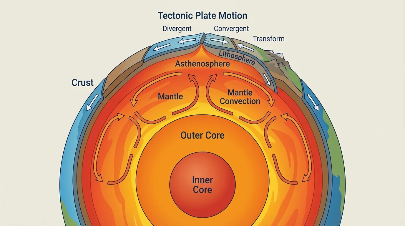
The energy driving plate motion comes mainly from Earth's internal heat. Some of this heat remains from Earth's formation, and some comes from the radioactive decay of elements within the planet. This heat causes material in the mantle to circulate slowly. These movements are often described as mantle convection, though plate motion is more complex than a simple conveyor belt model.
Scientists usually describe three major forces that help move plates. Convection in the mantle transfers heat and contributes to motion. Ridge push occurs because newly formed crust at mid-ocean ridges stands higher and tends to slide away from the ridge under gravity. Slab pull happens when a cold, dense oceanic plate sinks into the mantle at a subduction zone, pulling the rest of the plate with it. Many geologists consider slab pull one of the strongest influences on plate motion.
Why plates can move even though rock is solid
At everyday timescales, rocks seem completely rigid. But over millions of years, high temperature and pressure allow some deep rocks to flow very slowly. This means Earth's rigid surface plates can move over deeper material without the whole planet behaving like a brittle shell.
A useful way to think about this is to compare it to extremely thick material such as warm asphalt or glacier ice. It may resist motion in the short term, but over long times it can deform. Earth's mantle does something similar, though the physics is more complicated and the timescales are vastly longer.
Plate tectonics became widely accepted because multiple independent lines of evidence all point to the same conclusion. Some of the strongest evidence comes from the ocean floor, where [Figure 2] illustrates how new crust forms at mid-ocean ridges and moves outward on both sides.
One early clue was the way continents seem to fit together. South America and Africa, for example, have coastlines that appear like pieces of a puzzle. The fit is not perfect if you compare modern shorelines, but it becomes much stronger when geologists compare the edges of the continental shelves beneath the water.
Another clue came from fossils. Identical fossils of land organisms have been found on continents now separated by oceans. A famous example is Mesosaurus, a freshwater reptile whose fossils are found in both South America and Africa. Since a freshwater animal could not have crossed a vast salty ocean, the simpler explanation is that those continents were once connected.
Geologists also found matching rock layers and mountain belts on widely separated continents. Parts of the Appalachian Mountains line up with mountain belts in Greenland and northern Europe when the continents are reconstructed into earlier positions. Ancient climate evidence adds even more support: glacial deposits are found in regions that are now tropical, and coal deposits, which form from lush swamp vegetation, are found in places that are now much colder.
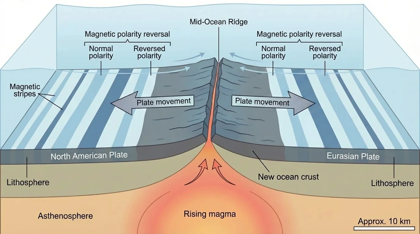
The ocean floor provided especially convincing evidence. In the mid-20th century, scientists mapped long undersea mountain chains called mid-ocean ridges. They also discovered that the seafloor gets older as you move away from the ridge. That makes sense if new crust is forming at the ridge and spreading outward. This process is called seafloor spreading.
There is also a magnetic record in oceanic rocks. When lava cools, iron-bearing minerals can align with Earth's magnetic field. Because Earth's magnetic field has reversed many times in the past, bands of ocean crust preserve alternating magnetic patterns. These stripes are symmetrical on both sides of ridges, matching the idea of crust forming at the center and moving outward equally.
Today, plate motion can be measured directly with GPS and satellite techniques. Continents are not just assumed to move; they are observed moving by a few centimeters each year. That is roughly the speed at which fingernails grow, but over millions of years it adds up to enormous distances.
The Atlantic Ocean is still widening because seafloor spreading continues along the Mid-Atlantic Ridge. At the same time, parts of the Pacific Ocean are shrinking where oceanic plates are being subducted back into the mantle.
Most major tectonic activity happens where plates meet. These margins are called plate boundaries, and they are grouped into three main types: divergent, convergent, and transform.
At a divergent boundary, plates move apart. Magma rises to fill the gap, cools, and forms new crust. In the oceans, this creates mid-ocean ridges. On land, divergence can produce rift valleys. The East African Rift is an important example where a continent is beginning to split.
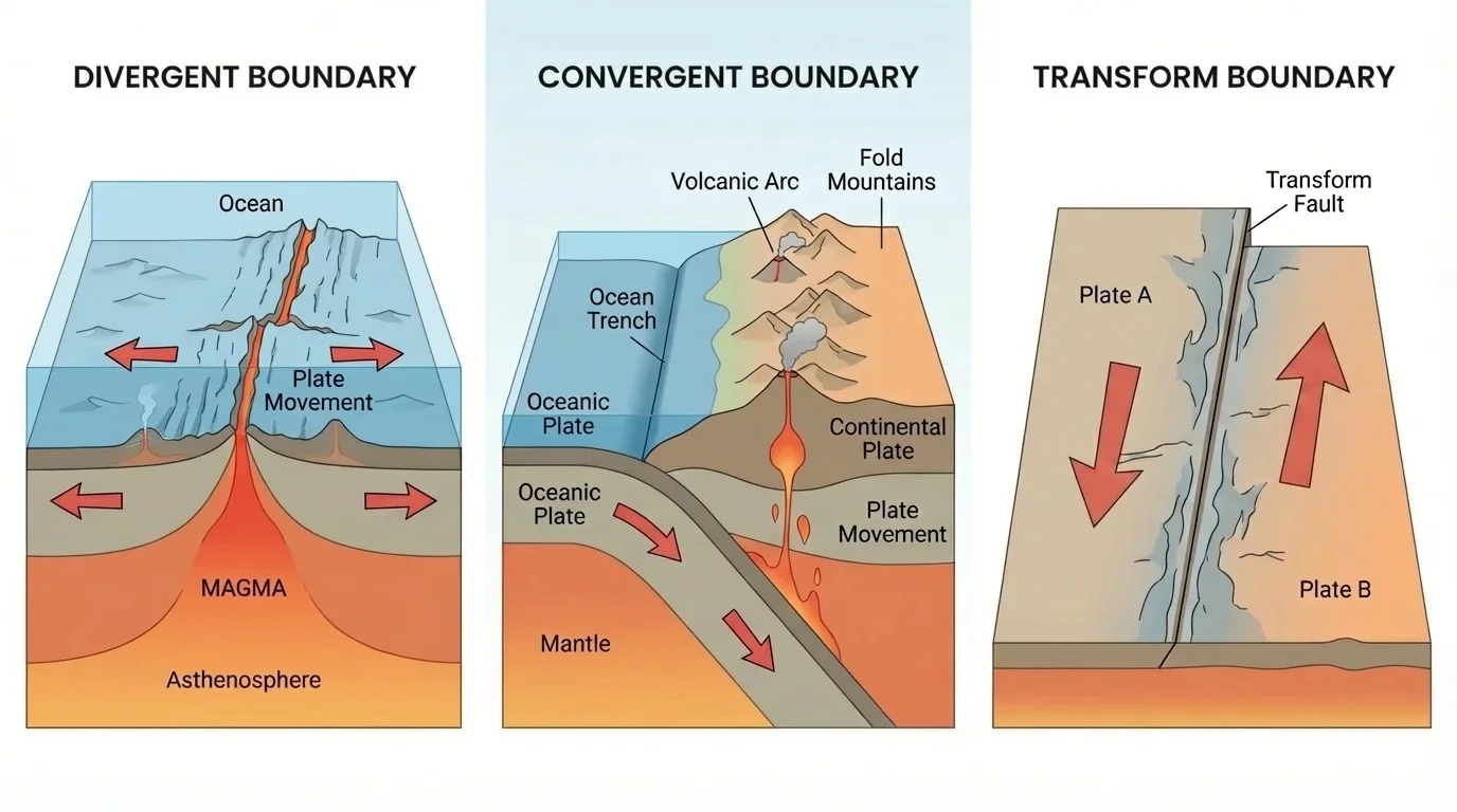
At a convergent boundary, plates move toward one another. What happens next depends on the kind of crust involved. An oceanic plate may sink beneath another plate in a process called subduction, or two continents may collide and crumple upward into high mountain ranges.
At a transform boundary, plates slide past each other horizontally. Crust is neither created nor destroyed there. Instead, stress builds up as rocks catch and then suddenly slip, producing earthquakes. The San Andreas Fault is one of the best-known transform boundaries.
The pattern of earthquakes and volcanoes around the world strongly reflects these boundary types. Earthquakes cluster along all three boundary types, but volcanoes are especially common at subduction zones and divergent boundaries. This is why plate tectonics is so useful for hazard prediction and risk planning, even though it cannot tell us the exact day an earthquake will happen.
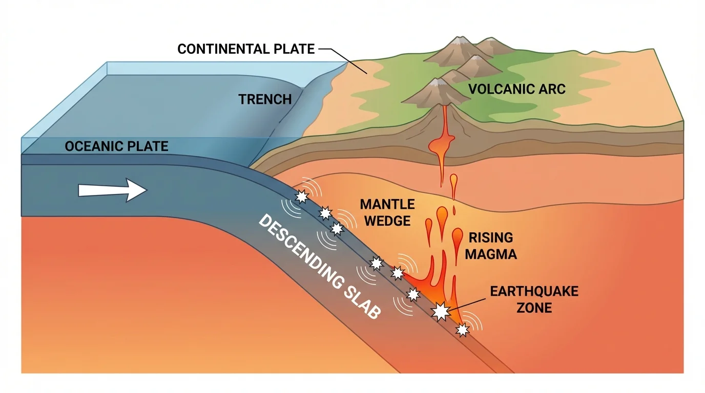
Convergent boundaries are especially important because they create some of Earth's most dramatic features. When one plate is forced beneath another, the process is called subduction, and the descending plate carries water-rich minerals deep into the mantle. As [Figure 4] illustrates, this helps generate magma, which can rise to form volcanoes.
In oceanic-continental convergence, the denser oceanic plate sinks beneath the continental plate. This creates a deep ocean trench offshore and a volcanic mountain chain on land. The Andes formed this way as the Nazca Plate subducts beneath the South American Plate.
In oceanic-oceanic convergence, one oceanic plate sinks beneath the other. This creates trenches and volcanic island arcs. Japan and the Aleutian Islands are examples of this type of setting. These regions often experience both powerful earthquakes and explosive volcanic eruptions.
In continental-continental convergence, neither plate subducts easily because continental crust is relatively buoyant. Instead, the crust thickens, folds, and rises. The Himalayas formed when the Indian Plate collided with the Eurasian Plate. This process is still happening today, which is why the region remains seismically active.
| Boundary interaction | Main process | Typical features | Example |
|---|---|---|---|
| Oceanic-continental | Oceanic plate subducts | Trench, volcanic mountains, earthquakes | Andes |
| Oceanic-oceanic | One oceanic plate subducts | Trench, island arc, earthquakes | Japan |
| Continental-continental | Collision and crustal thickening | High mountains, earthquakes | Himalayas |
Table 1. Major types of convergent boundary interactions and the landforms they commonly produce.
The distribution of deep earthquakes also supports subduction. In some zones, earthquakes occur along a sloping plane that traces the descending plate into the mantle. This pattern gives scientists a three-dimensional picture of how a plate sinks beneath another. It also connects directly back to the boundary patterns shown earlier in [Figure 3].
Case study: why the west coast of South America is so tectonically active
Step 1: Identify the boundary type.
The Nazca Plate, which is oceanic, moves toward the South American Plate, which is continental.
Step 2: Determine what the denser plate does.
The oceanic Nazca Plate subducts beneath South America.
Step 3: Predict the geologic results.
Subduction produces an offshore trench, frequent earthquakes, melting in the mantle above the slab, and magma that feeds volcanoes.
Step 4: Connect this to actual features.
The Peru-Chile Trench, the Andes Mountains, and many earthquakes and volcanoes along the western edge of South America match this pattern.
This kind of reasoning is what makes plate tectonics so powerful. A geologist can identify plate interactions and then predict the kinds of landforms, hazards, and rock patterns likely to be present.
Not all volcanoes form at plate boundaries. Some occur above long-lived rising plumes of unusually hot mantle material called hot spots. A volcanic chain can form as a plate moves over a relatively stationary hot spot, and [Figure 5] shows how this creates a trail of older volcanoes behind the active one.
The Hawaiian Islands are the classic example. The island above the hot spot is volcanically active, while islands farther away are older and often eroded. This age pattern records the direction of plate motion. Hot spots therefore provide another independent way to study tectonic movement.
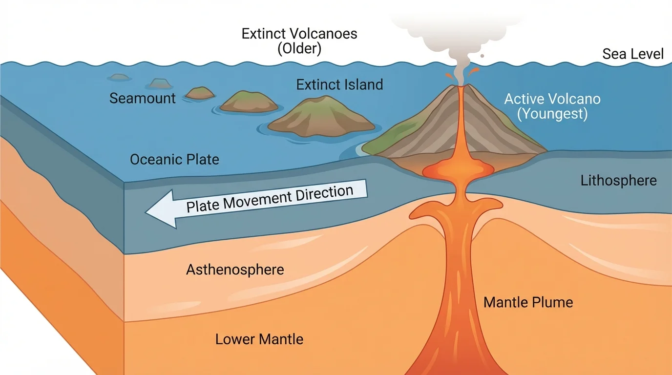
Hot spots show that Earth's interior can affect the surface even away from boundaries. However, they do not replace plate tectonics; they fit within the larger theory. In fact, hot spot tracks help test plate reconstructions and strengthen our understanding of past plate motion.
Plate tectonics is essential for understanding Earth's past because the surface is constantly being rearranged. Continents merge into supercontinents and later break apart. Oceans open, widen, shrink, and disappear. Mountain ranges rise and erode. Oceanic crust forms at ridges and is eventually recycled into the mantle at subduction zones.
One famous supercontinent was Pangaea, which existed roughly 300 million years ago. Its breakup helped create the modern Atlantic Ocean and rearranged climates, coastlines, and habitats. When geologists reconstruct Pangaea, the fossil, rock, and glacial evidence fits together in ways that are difficult to explain by any other theory.
Plate movements also influence long-term climate. The position of continents changes ocean currents and wind patterns. Mountain building can alter rainfall patterns and erosion. Volcanic activity can release gases such as \(\textrm{CO}_2\) over geologic timescales, while weathering of uplifted rocks can help remove \(\textrm{CO}_2\) from the atmosphere over long periods. These interactions show that Earth's systems are interconnected.
Rocks preserve evidence of the environments in which they formed. Sedimentary layers, fossils, volcanic rocks, and metamorphic features are part of the record geologists use to reconstruct tectonic history.
Because oceanic crust is recycled, very old ocean floor is rare. Continental crust, by contrast, can survive much longer. That is one reason continents preserve such a rich record of ancient events. Plate tectonics helps explain why some parts of Earth's surface are young and constantly renewed while others preserve rocks billions of years old.
Plate tectonics matters far beyond the classroom. Cities near plate boundaries face major earthquake risk. Subduction zones can generate tsunamis when the seafloor suddenly shifts. Volcanic regions may be dangerous, but they can also create fertile soils and provide geothermal energy. Knowing the tectonic setting of a region helps engineers, planners, and emergency managers make better decisions.
Natural resources are also connected to tectonic processes. Many metal ores are associated with ancient volcanic and hydrothermal systems linked to plate boundaries. Oil and natural gas accumulate in sedimentary basins whose formation is often influenced by tectonic stretching or subsidence. Even groundwater systems can be shaped by faults and folded rock layers.
Modern hazard maps rely heavily on the same plate-boundary patterns introduced earlier in [Figure 3]. That is a major reason this theory is called unifying: it explains both the deep past preserved in rocks and the present-day risks that affect human societies.
"The present is the key to the past."
— A core idea in geology
Even though plate movement is slow, scientists can measure it quantitatively. A simple relationship is distance divided by time:
\[\textrm{rate} = \frac{\textrm{distance}}{\textrm{time}}\]
If a plate moves \(120 \textrm{ km}\) in \(4\) million years, then its average rate is \(\dfrac{120 \textrm{ km}}{4 \times 10^6 \textrm{ years}} = 0.00003 \textrm{ km/year}\). Since \(1 \textrm{ km} = 100{,}000 \textrm{ cm}\), this equals \(3 \textrm{ cm/year}\).
Worked example: calculating a plate speed
A volcanic island chain shows that a plate moved \(240 \textrm{ km}\) over a hot spot in \(8\) million years. Find the average speed in centimeters per year.
Step 1: Use the rate formula.
\(\textrm{rate} = \dfrac{\textrm{distance}}{\textrm{time}}\)
Step 2: Substitute the values.
\(\textrm{rate} = \dfrac{240 \textrm{ km}}{8 \times 10^6 \textrm{ years}} = 0.00003 \textrm{ km/year}\)
Step 3: Convert kilometers per year to centimeters per year.
\(0.00003 \textrm{ km/year} \times 100{,}000 \textrm{ cm/km} = 3 \textrm{ cm/year}\)
The plate's average speed is \(3 \textrm{ cm/year}\).
A few centimeters per year may sound tiny, but over \(10\) million years, a plate moving at \(5 \textrm{ cm/year}\) would travel \(500 \textrm{ km}\). That is enough to radically reshape oceans, mountain belts, and climate patterns. Geologic change does not have to be fast to be powerful.