Have you ever noticed that the ground under your feet can be hard rock in one place, soft soil in another place, and sandy near a beach or stream? Earth is full of different materials and shapes. Some places have hills, some have flat land, and some have rivers or ponds. These parts of Earth work together to make homes for plants, animals, and people.
Earth is a big system. A system is a group of parts that work together. On Earth, land, water, air, and living things all affect one another. When rain falls, water moves over land. When water moves, it can carry sand and tiny pieces of rock. When soil is deep and rich, plants can grow well. Animals then use plants and water to survive.
Even though the ground may seem still, Earth is active. Some changes happen where we can easily see them, like a stream moving mud after rain. Some changes happen very slowly over a long time, like land rising into mountains. Learning about land, water, rocks, and maps helps us understand the world around us.
[Figure 1] Every area has its own shapes of land and kinds of water. Landforms are the natural shapes of the land. A hill is raised land. A plain is a large area of flat land. A valley is lower land between higher places. Water can also be found in many forms, such as a river, stream, lake, or pond.
A landform is an important part of a place. A river is flowing water that moves across land. A stream is like a smaller river. A lake is a larger body of water surrounded by land. A pond is usually smaller than a lake. Some places have many kinds of land and water close together.
These features matter because they affect what can live there. Ducks may live near ponds. Fish may live in streams and lakes. Tall grass may grow on flat plains. Trees may grow along rivers where water is easier to find.
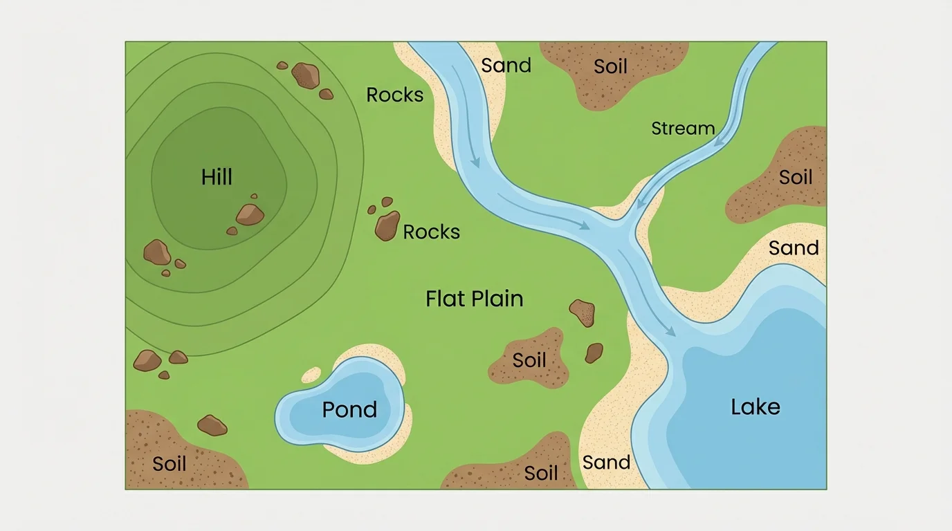
When we look at an area, we can ask simple questions. Is the land high or low? Is there moving water or still water? Is the ground rocky, muddy, or sandy? These questions help us describe a place clearly.
Landforms are natural shapes of Earth's surface, such as hills, valleys, and plains. Bodies of water are places where water collects or flows, such as rivers, lakes, streams, and ponds.
One small park can include grass, trees, a shallow pond, and a walking path on soil. A larger region may include mountains, long rivers, forests, and beaches. Earth has many patterns, and maps help us notice them.
[Figure 2] Under and around us are materials that help shape the land. Rocks, soil, and sand are found in many places where plants and animals live. They are not all the same. Some rocks are large and hard. Some soil is dark and soft. Sand is made of tiny grains.
Rocks can be on the ground, in cliffs, in streambeds, or under the soil. Soil is the top layer where many plants grow. It often contains tiny rock pieces, bits of dead plants and animals, water, and air. Sand may be found at beaches, deserts, playgrounds, and river edges.
Plants need soil because roots grow into it and take in water. Animals use these materials too. Ants tunnel in soil. Lizards may rest on warm rocks. Crabs dig in sand. Even when we cannot see it, the ground below helps living things survive.
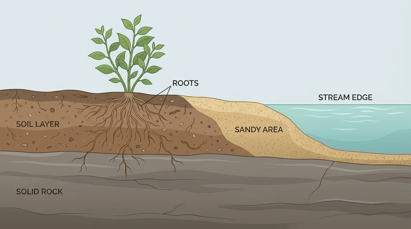
Soil can look different from place to place. In one yard it may be dark and crumbly. Near a river it may be muddy. Near a beach it may be mixed with sand. These differences can change which plants grow best.
Why ground materials matter
Rocks, soil, and sand are part of Earth's surface. They hold water in different ways, support plant roots in different ways, and create different homes for animals. A place with thick soil may grow grasses and flowers well, while a sandy place may dry out faster.
People also use these materials. Rock can be used for building. Soil is important for gardens and farms. Sand is used in construction and can also be shaped by wind and water into dunes and bars.
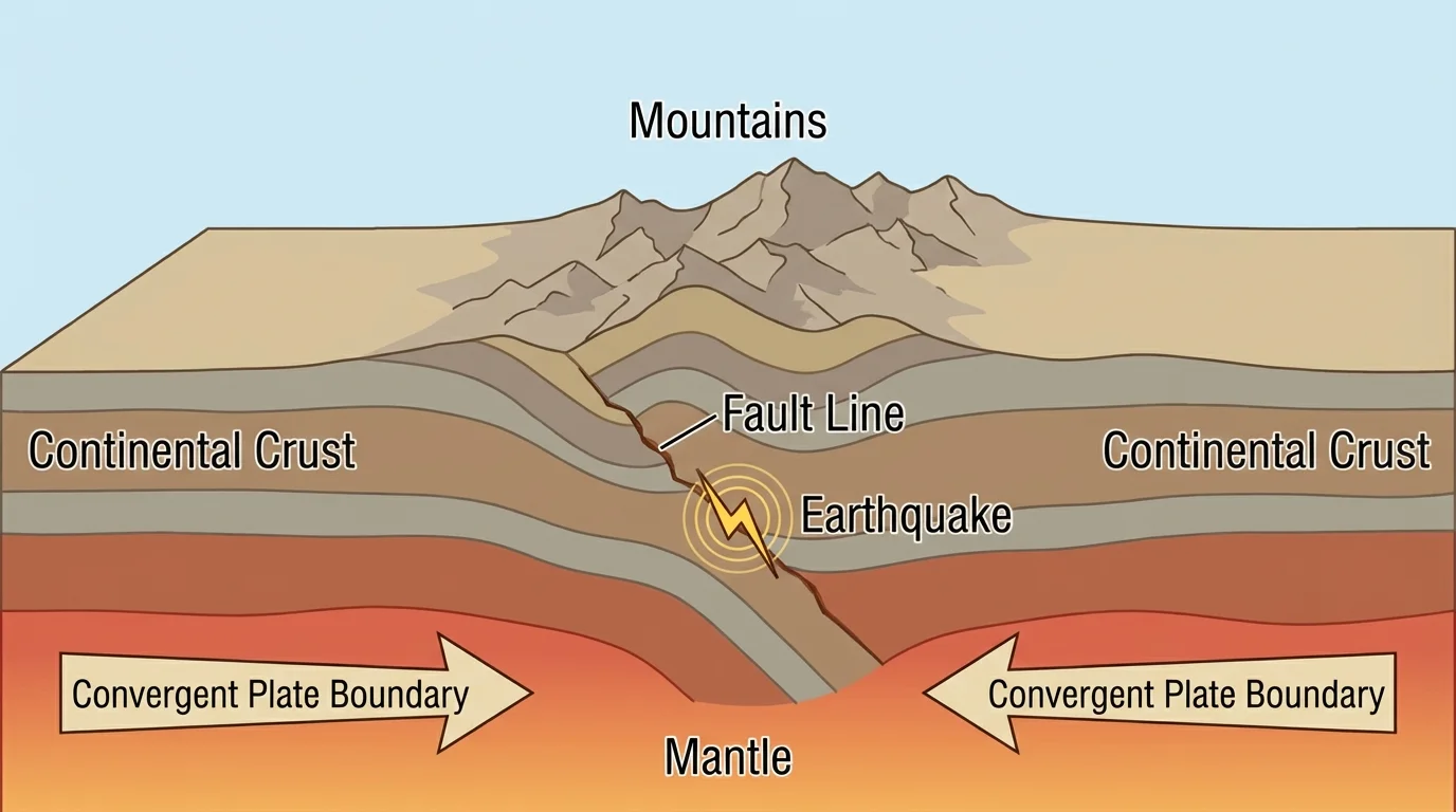
[Figure 3] Earth's surface is not exactly the same all the time. Deep under Earth's surface are very large pieces called tectonic plates that move very slowly. The movement of these plates is called plate tectonics. Grade 2 students do not need every detail, but it is helpful to know that Earth's crust can move slowly over a very long time.
When these huge pieces push together, they can help form mountains. When they slip suddenly, the ground can shake in an earthquake. These events remind us that Earth is active. Most of the time, plate movement is much too slow for us to see day by day.
Other changes happen at Earth's surface. Wind can blow sand from one place to another. Rain can wash soil downhill. Rivers can carry tiny rock pieces. Over time, moving water can change the shape of riverbanks and make new patterns in the land.
Some changes are fast, such as a flood after a strong storm. Some changes are slow, such as a valley getting wider over many years. In both cases, land and water interact. That means they affect each other.
Mountains can grow when parts of Earth push together, but the same mountains can also be worn down by wind, rain, and ice over time. Earth is always changing, even when the changes are too slow to notice in one day.
Earlier we saw in [Figure 2] that soil sits above rock and can be moved more easily than solid rock. That is one reason heavy rain may change the top layer of land faster than the deeper rock below.
A habitat is a place where a plant or animal lives. Habitats depend on land and water. A frog may live near a pond because it needs water. A cactus may live in sandy, dry ground. A deer may live in a forest where there is soil, water, and many plants to eat.
Different places offer different needs. A stream can give water to animals. Soil can help plants grow. Rocks can provide shelter. Sand can become a nesting place for some animals. Even a small patch of land can support many living things.
Think about a pond area. The pond holds water. Wet soil forms near the edge. Reeds and grasses grow there. Insects buzz above the water. Birds come to drink. Turtles may rest on rocks nearby. One part of Earth connects to many others.
Real-world example: a riverbank habitat
Step 1: Notice the materials.
A riverbank may have soil, pebbles, sand, and flowing water.
Step 2: Notice the plants.
Grass, shrubs, and trees often grow there because water is nearby.
Step 3: Notice the animals.
Birds, insects, fish, frogs, and small mammals may all use the same area in different ways.
This shows how Earth materials and water help create a habitat.
The plate movement we discussed in [Figure 3] can change land over very long times, and those land changes can create new habitats such as mountains, valleys, and coastlines.
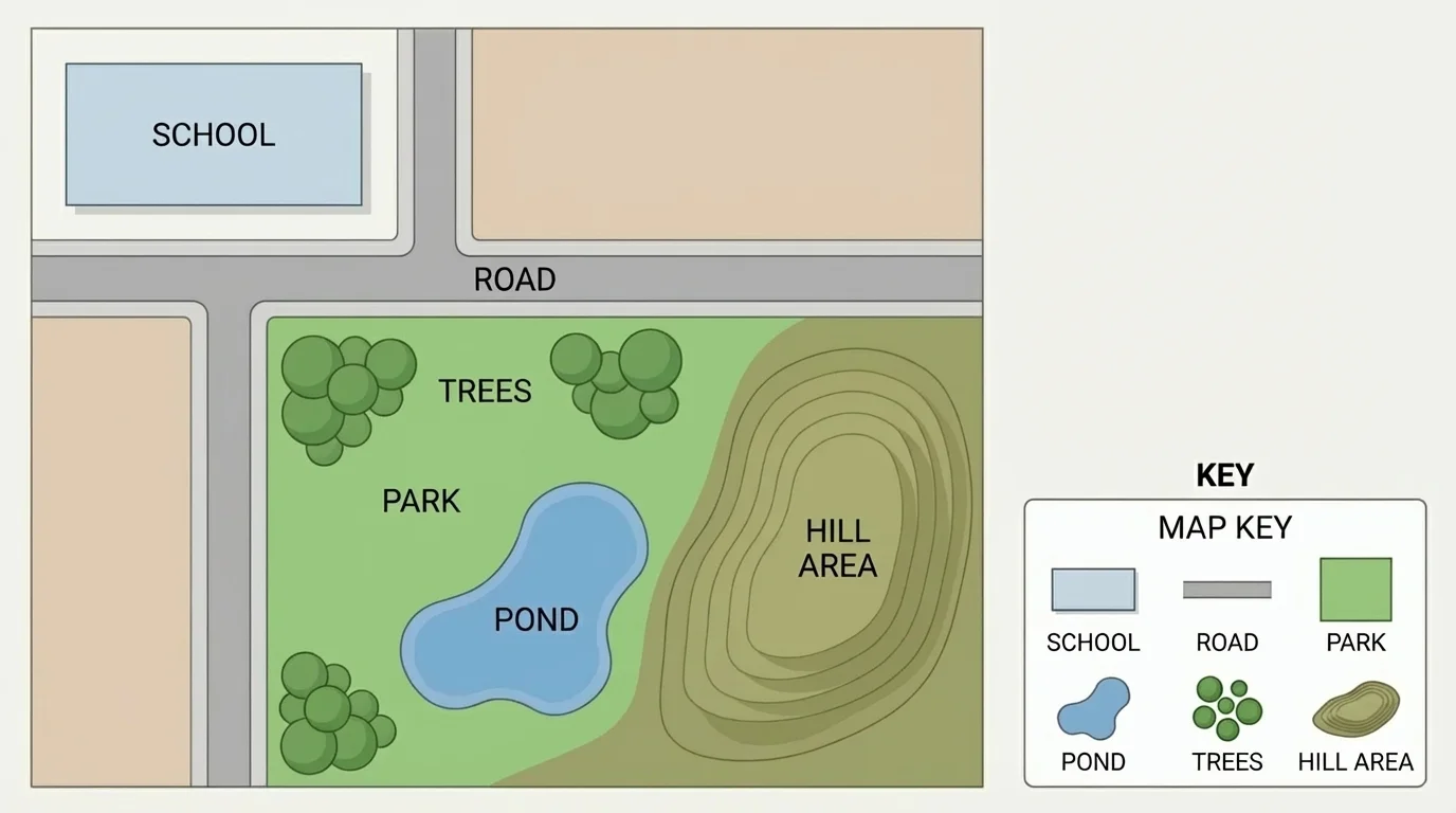
[Figure 4] When people want to show where things are located, they use a map. A map is a drawing of a place seen from above. It can show how one small area includes roads, water, trees, and buildings. Maps help us understand the shape of the land and the places where water is found.
A map can show many things. It can show where a river bends, where a pond sits, where a hill rises, or where a school stands. Some maps show real shapes. Some use colors and symbols. Blue often shows water. Green may show parks or forests.
Maps help us compare places. One map may show that a town is near a lake. Another may show that a farm is on flat land. Another may show that homes were built away from a river that floods. Maps are useful tools for scientists, builders, farmers, and families.
Maps are especially helpful because they make big places easier to study. We cannot fly up into the sky every time we want to look at an area, but a map gives us a top view. That helps us see where things are in relation to one another.
You may already know that directions such as left, right, near, and far help describe location. Maps use that same idea, but in a more organized way so many people can understand the same place.
As we saw earlier in [Figure 1], one area can include both landforms and bodies of water. A map puts those features into one clear picture so we can study the whole area at once.
A simple map often includes a title, labels, and symbols. A symbol is a small picture or mark that stands for something real. For example, a blue shape might mean a pond. A tree symbol might mean woods. A black line might mean a road.
Many maps also have a key. A key tells what the symbols mean. If you see a blue line on a map, the key may tell you it stands for a stream. This helps different readers understand the same map in the same way.
Students can think about mapping a classroom, playground, or garden. Where is the big tree? Where is the path? Is there a sandy area? Is there a puddle or pond nearby? A map lets us record those details carefully.
| Map part | What it does | Example |
|---|---|---|
| Title | Tells what place the map shows | School Garden Map |
| Symbol | Stands for something real | Blue shape for pond |
| Label | Names a place | Hill, road, stream |
| Key | Explains symbols | Tree symbol = woods |
Table 1. Main parts of a simple map and how each part helps the reader.
Maps can show shape as well as location. A pond may be round. A river may curve. A hill may be shown by symbols or shapes that represent higher land. The exact way a map shows these depends on the kind of map, but the goal is always to help people understand a place.
People study land, water, and maps for many practical reasons. Farmers need to know about soil and water. Builders need to know if land is rocky, sandy, or flat. Park workers need to know where trails, streams, and ponds are located.
Scientists also use maps and observations to watch how Earth changes. They may look at riverbanks after rain, beaches after storms, or hillsides after landslides. By doing this, they learn how Earth systems interact.
Families use this knowledge too. If a place floods often, people may choose safer areas for homes. If a garden needs better soil, people may improve it. If a map shows a pond in a park, visitors can find it more easily.
"The Earth has music for those who listen."
— George Santayana
When we pay attention to land, water, rocks, soil, sand, and maps, we begin to read Earth like a story. Each stream, hill, pond, and patch of soil tells us something about how that place works and who can live there.