If you could fly high above Earth and look down at the whole planet, you would notice something surprising: giant mountains, deep ocean trenches, earthquakes, and volcanoes are not scattered randomly. They form patterns. Some stretch in long lines. Some cluster around the edges of oceans. Some form within continents. Earth may look messy at first, but when scientists make maps, they discover that many of its biggest features fit together like clues in a puzzle.
Earth's surface includes high places, low places, dry land, and deep water. A mountain range is a long chain of mountains connected across a large area. A deep ocean trench is a very deep, narrow valley in the ocean floor. Earthquakes are sudden shakings of the ground, and volcanoes are openings where molten rock, ash, and gases can escape from inside Earth.
When scientists compare maps of these features, they see that many of them line up in long belts or bands. Major mountain chains often form inside continents or along their edges. Many volcanoes and earthquakes happen in narrow zones instead of spreading evenly across the planet. This tells us that Earth's surface is active and connected.
Pattern means something happens in a repeated or organized way. On Earth, patterns help us notice that certain features are often found in the same kinds of places.
Boundary means a dividing line or edge between areas. On Earth, many important features form near the edges of large pieces of the crust.
Looking for patterns is one of the most powerful tools in science. If volcanoes appeared anywhere at all, it would be much harder to study them. But because they often occur in bands, scientists can learn more about where they happen and why.
[Figure 1] Maps reveal global patterns by helping us see where mountains, trenches, volcanoes, and earthquakes are located across the world. A physical map can show landforms such as mountains, plains, and valleys. Ocean maps can show features under the water, including ridges and trenches. Some special maps use dots or symbols to mark where earthquakes and volcanoes happen.
When we study one map by itself, we learn where a feature is. When we compare several maps, we learn even more. For example, a map of earthquakes and a map of volcanoes often show similar bands. A map of mountain ranges may show that many of them lie near the edges of continents. A map of deep trenches may match places where strong earthquakes happen under the ocean.
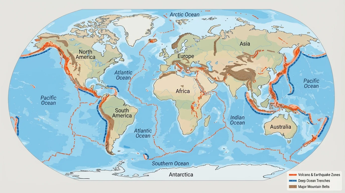
Maps can also show us that the ocean floor is not flat. Long ago, people knew less about the deep ocean because it was hard to explore. Today, tools such as sonar and satellites help scientists map the seafloor. These maps reveal ridges taller than some mountains on land and trenches deeper than many students imagine.
Another useful thing about maps is scale. A world map helps us notice big patterns, while a local map helps us study one area closely. Scientists use both. They may look at a world map to find a pattern and then zoom in on one part to study it in detail.
[Figure 2] Many of the world's great mountain systems form in connected belts. These belts are often within continents or near their edges. The Rocky Mountains in North America and the Andes Mountains along the western edge of South America are famous examples. The Himalayas in Asia, home to Mount Everest, formed deep within a continent where huge pieces of Earth's crust pushed together.
Mountain ranges can form when parts of Earth's surface press against each other. The crust can crumple, fold, and be uplifted over a very long time. This does not happen in one afternoon or even one lifetime. It happens slowly over millions of years. Even though mountains look solid and still, they are signs that Earth changes over time.
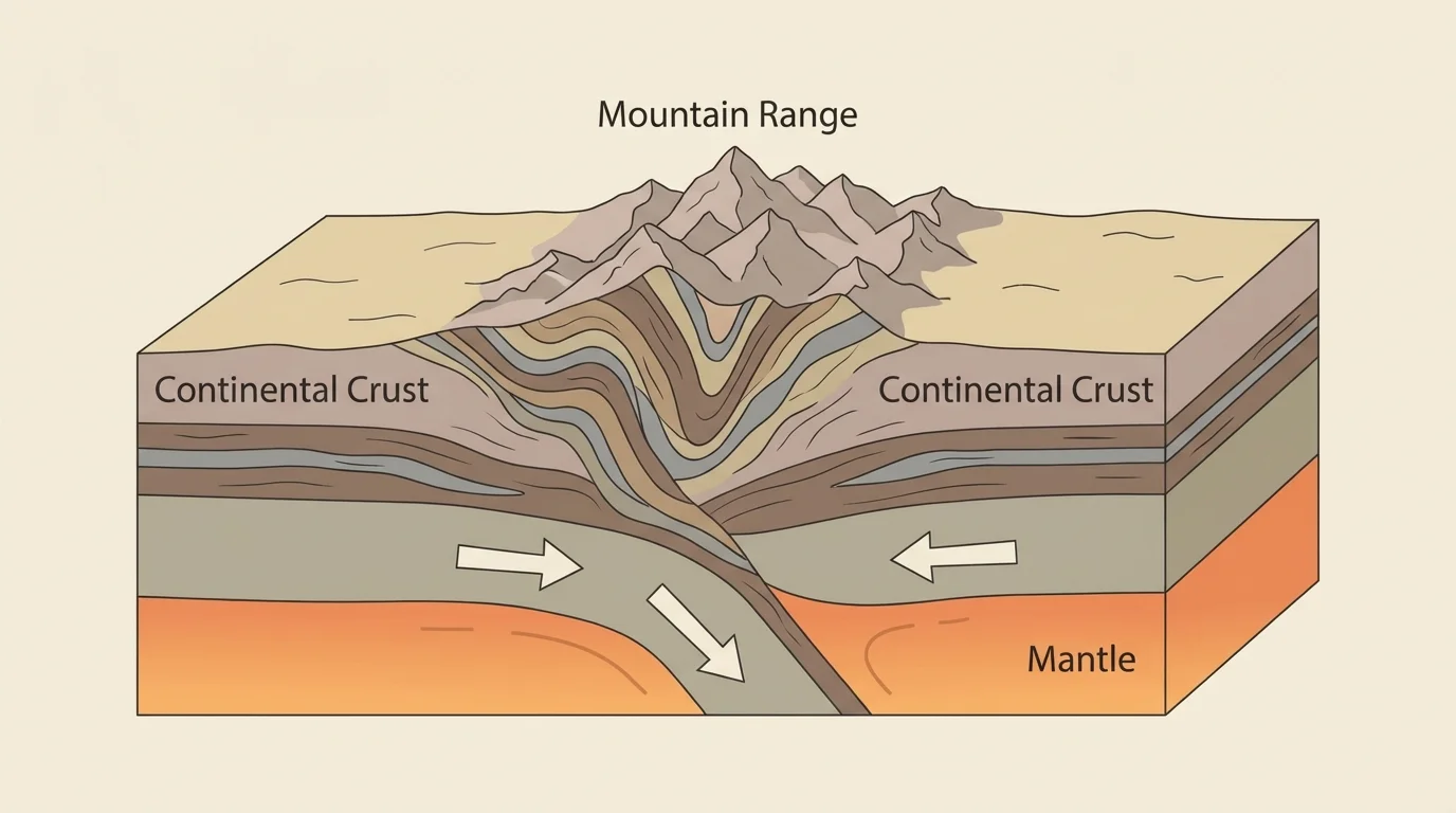
Some mountain chains stand near the edges of continents, where land meets ocean. The Andes are one example. Other mountain chains, like the Himalayas, are far from the sea today but formed where huge land areas collided. This is one reason scientists say major mountain chains often form inside continents or near their edges.
Mountains affect life around them. They can change weather by blocking winds and forcing air upward, which can lead to rain or snow. Rivers often begin in mountains. People build roads through mountain passes, and animals live in habitats found at different heights. So mountain patterns matter not only to geologists but also to communities, plants, and animals.
The Himalayas are still rising a little because the enormous pieces of Earth beneath them are still pushing together. Earth's surface can keep changing even when the movement is too slow to see with our eyes.
When we compare mountain maps with other maps, we begin to see how Earth's systems connect. As we saw earlier on the world map in [Figure 1], many mountain belts are part of larger global patterns rather than isolated places.
[Figure 3] The ocean floor has its own landscapes, and this figure helps us picture them. Beneath the water are long mountain chains, broad flat regions, underwater volcanoes, and very deep trenches. The ocean floor is one of the best places to see how Earth's features follow patterns.
A mid-ocean ridge is a long underwater mountain chain. One famous example is the Mid-Atlantic Ridge, which runs down the middle of the Atlantic Ocean. A ridge is a raised area, almost like a seam running along the ocean floor. Nearby, there may be cracks and volcanoes where hot material from below helps shape new crust.
Another important feature is the trench. The Mariana Trench in the Pacific Ocean is one of the deepest places on Earth. Trenches are usually long and narrow. They often form near the edges of oceans, especially around the Pacific. Many strong earthquakes happen close to these deep areas.
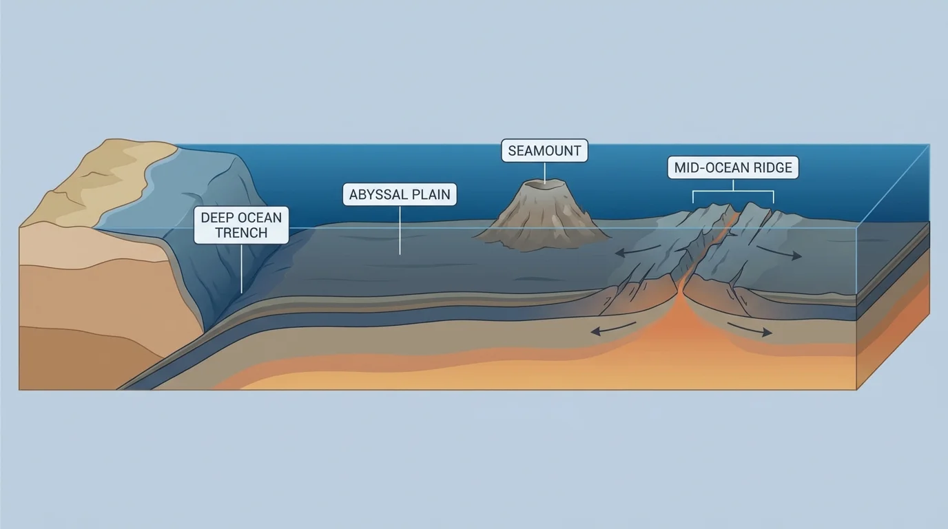
The ocean floor also includes abyssal plains, which are wide, flat parts of the deep ocean, and seamounts, which are underwater mountains. Some seamounts rise high enough to become islands if they reach above sea level. The Hawaiian Islands, for example, are the tops of huge volcanic mountains rising from the ocean floor.
Ocean maps help scientists compare where trenches, ridges, and earthquakes are found. The patterns are too large to understand by looking from a beach. But on maps, the relationships become much clearer. Later, when we think about moving parts of Earth's crust, the features in [Figure 3] make even more sense.
[Figure 4] Most earthquakes and volcanoes happen in long zones or belts instead of random spots, especially around the Pacific Ocean. These belts are often close to the boundaries between continents and oceans or between large parts of Earth's crust beneath land and sea. This is one of the biggest patterns scientists observe on Earth.
One famous example is the Ring of Fire. This is a broad belt around much of the Pacific Ocean where many volcanoes and earthquakes occur. Places around the Pacific, including Japan, Indonesia, the west coasts of North and South America, experience many of these events.
Not every earthquake causes major damage, and not every volcano erupts often. But when scientists place many events on a map, the banded pattern stands out. Earthquakes happen when rocks suddenly move along faults in Earth's crust. Volcanoes often form where molten rock can rise toward the surface. Because the same large Earth processes can cause both, their maps often overlap.
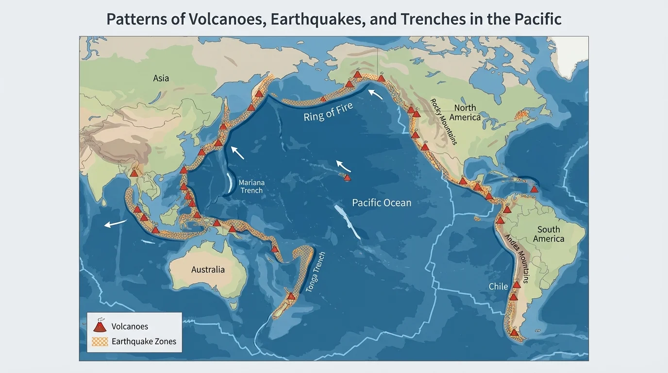
There are also places with earthquakes but few volcanoes, and places with volcanoes that do not fit every pattern exactly. Science includes patterns and exceptions. Still, the general rule is very strong: many earthquakes and volcanoes occur in bands.
This matters to people. Communities in these zones prepare for shaking ground, volcanic ash, lava, and tsunami danger. Scientists use maps, sensors, and past records to help warn people and make safer choices. The banded pattern in [Figure 4] helps explain why some regions study earthquake and volcano safety very carefully.
[Figure 5] Earth's outer layer is broken into huge pieces that move very slowly, and this figure shows the three main ways these pieces can interact. These pieces are often called tectonic plates. They move so slowly that people cannot watch them shift from day to day, but over millions of years their motion changes Earth's surface in major ways.
Sometimes plates push together. Sometimes they pull apart. Sometimes they slide past each other. Each kind of motion can create certain features and events. When plates push together, they may build mountains or help form trenches and volcanoes. When plates pull apart, ridges can form on the ocean floor. When plates slide past, earthquakes often happen.
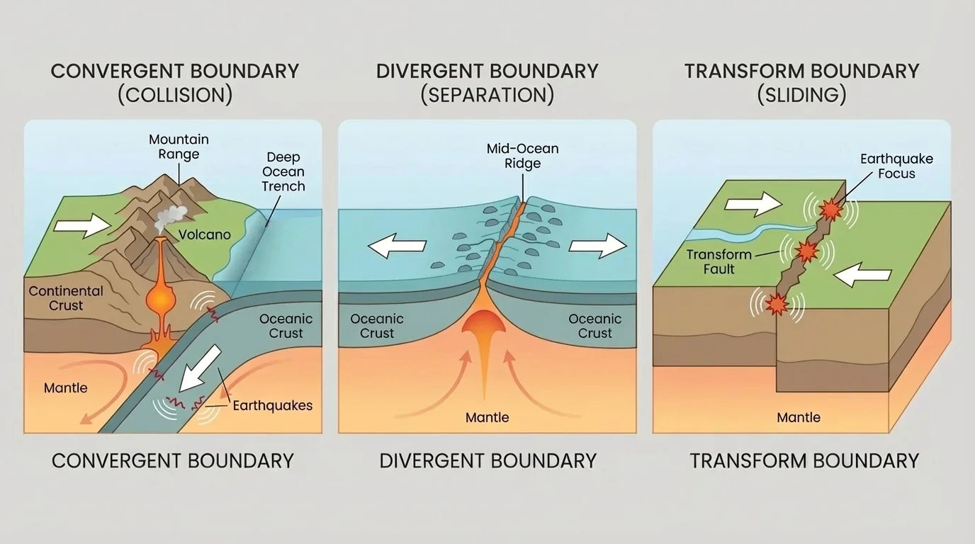
This is why maps are so helpful. A map does not just tell us where something is. It can also give clues about what Earth is doing there. If we see a line of volcanoes near a trench, that suggests a kind of plate interaction. If we see a great mountain belt inside a continent, that suggests slow powerful forces have been pushing crust together.
Earth as a moving system
Earth's continents and ocean basins are not fixed forever. The surface changes because the crust moves in large pieces. Those movements connect mountain building, trench formation, earthquakes, volcanoes, and the shape of the ocean floor.
Scientists gather evidence from maps, rock studies, earthquake records, and measurements of plate motion. Even for young learners, the big idea is clear: the patterns on Earth's surface happen for reasons. Mountains, trenches, quakes, and volcanoes are connected parts of one system.
Knowing Earth's patterns helps people live more safely. Engineers and builders need to know if an area has frequent earthquakes. Emergency planners need volcano maps to prepare evacuation routes. Fishermen, sailors, and scientists use ocean-floor maps to understand the shape of the seafloor. Pilots may avoid dangerous volcanic ash in the air.
These patterns also help scientists explore Earth's past. If they find a mountain belt or old volcanic rocks, they can ask what plate motion may have happened there long ago. Maps are like detective tools. They help us read Earth's history.
Real-world example: Why maps matter in Japan
Japan lies in a region with many earthquakes and volcanoes.
Step 1: Scientists map where earthquakes happen.
These maps show many earthquake zones around Japan.
Step 2: Scientists compare earthquake maps with volcano maps and ocean maps.
They notice nearby trenches, volcanic chains, and active plate boundaries.
Step 3: Communities use this information.
Schools practice safety drills, buildings are designed to handle shaking, and warning systems are improved.
This shows how understanding Earth's patterns can help protect people.
Places far from active boundaries can still have interesting landforms, but the strongest global patterns often appear near plate edges. That is why world maps are so valuable: they help us see the big picture and not just one local location.
Mountains rise, trenches sink, earthquakes shake, and volcanoes erupt, but these are not separate stories. They are linked. A mountain belt may tell us about plates pushing together. A trench may mark a plate boundary on the ocean floor. A band of volcanoes may show where material from inside Earth reaches the surface. An earthquake zone may reveal where the crust is under stress.
When students learn to read maps of Earth, they begin to think like scientists. They ask where features are, what patterns they make, and what those patterns mean. The more carefully we study maps, the more Earth's surface begins to make sense.
As we compare a world map, mountain belts, ocean-floor structures, and the Ring of Fire, the earlier figures stay connected. The global view in [Figure 1], the mountain-building process in [Figure 2], the ocean-floor shapes in [Figure 3], the Pacific belt in [Figure 4], and the plate motions in [Figure 5] all point to the same idea: Earth's features occur in patterns because Earth is active and changing.