After a heavy rain, a playground can have tiny channels cut into the dirt, and a stream that looked clear yesterday can turn brown today. That is a clue that Earth's surface is changing right before our eyes. Land may look solid and still, but moving water can slowly reshape it day after day.
The ground, rocks, and soil around us are part of Earth's surface. Rain, puddles, creeks, and rivers are part of another Earth system: water. When water moves across the land, these systems interact. The result can be a big change over time, even when each change looks small at first.
Erosion is the wearing away and movement of rock, soil, or sediment from one place to another. In this lesson, the main cause of erosion is moving water. Water can flow down a hill, across a field, or through a stream channel. As it moves, it can loosen soil and carry it away.
Sometimes this change is easy to spot. A dirt path may have grooves after a storm. A riverbank may look lower than it did before. A garden bed may lose soil when water rushes through it. These changes are all evidence that moving water affects the land.
Weathering is the breaking down of rock into smaller pieces.
Erosion is the movement of those pieces, often by water.
Sediment is small pieces of rock, soil, and other Earth materials that can be carried by water.
When students study Earth's surface, they look for evidence. Evidence can come from what they see, what they measure, and what changes over time. A scientist does not just say, "The land changed." A scientist asks, "What do I observe, and how can I measure it?"
It is important to tell these ideas apart. Weathering breaks material into smaller pieces. Erosion moves that material. If a rock cracks into pieces, that is weathering. If rainwater carries those pieces downhill, that is erosion.
In nature, these often happen close together. First, rock or soil may break apart. Then moving water carries the smaller pieces away. Even though both ideas matter, the main focus here is on erosion by water, because that is the change we are observing and measuring.
Water always moves from higher ground to lower ground because of gravity. When water flows downhill, it can push and carry loose material with it.
If you pour water over a small pile of dry soil, some of the soil may wash away. The soil did not move by itself. The water provided the force that moved it. That is why muddy water is often a sign that erosion is happening.
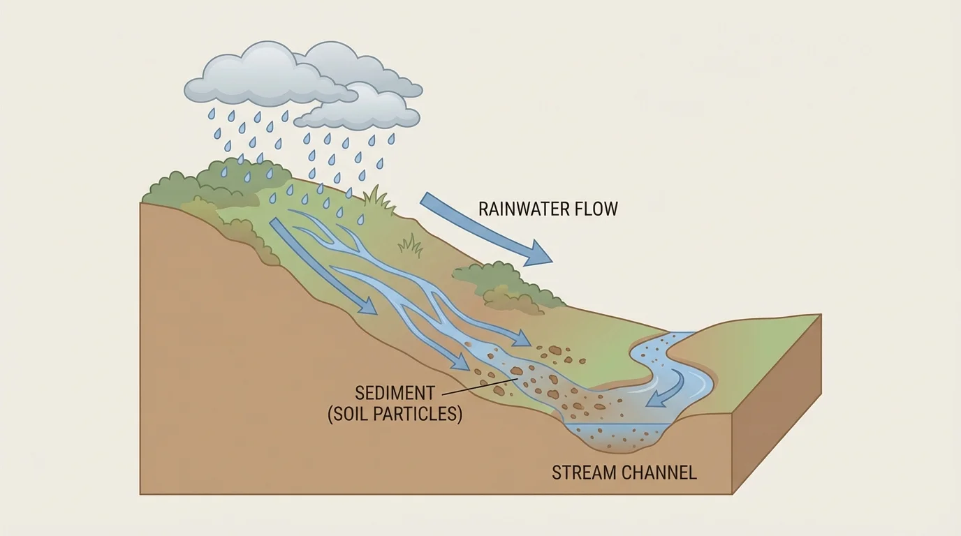
When rain falls on the ground, some of the water soaks in, and some flows over the surface. This flowing water can pick up sediment and carry it away, as [Figure 1] shows with water moving downhill and into a channel. The faster the water moves, the more power it usually has to move sediment.
At first, the change may be tiny. A thin sheet of water can carry away just a little soil from the top layer. Later, that water may collect into small paths. Those paths can grow into little channels. If enough water keeps moving through the same place, the channel can become deeper and wider.
Streams and rivers also erode land. Water bumps against the banks and the bottom of the channel. Over time, it can wear away the edges and move bits of soil and rock downstream. That is one reason riverbanks can change shape from season to season.
Look at the color of water after a storm. Clear water has fewer suspended particles. Brown or cloudy water often means that sediment is mixed in. That cloudy water is a clue that erosion is carrying material from one place to another.
A river can carry tiny clay particles, grains of sand, and even larger pebbles when water is flowing fast enough. Some of that material may later settle in a new place.
As the moving water slows down, it may drop some of the sediment. This means erosion in one place can lead to deposition in another place. A puddle may leave behind a ring of mud after the water disappears. A stream may leave extra sand on the inside edge of a bend.
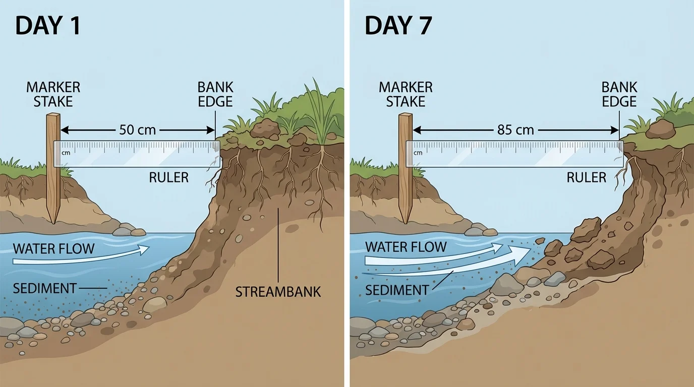
Scientists do more than notice that something "looks different." They make careful observations and compare measurements from different times. A marker and ruler, like the ones shown in [Figure 2], make it possible to see exactly how much land was lost from a streambank over several days.
An observation is information gathered with the senses. You might observe muddy water, exposed plant roots, a deeper groove in soil, or a bank that has crumbled. These clues help show that moving water has been active.
A measurement uses tools and numbers. For example, you might measure the width of a small channel, the distance from a stake to the edge of a bank, or the depth of a groove in the soil. Measurements are important because numbers let us compare change more clearly.
Suppose the distance from a marker stake to the streambank edge is initially measured as \(12 \textrm{ cm}\). A week later, the distance is \(8 \textrm{ cm}\). The bank edge moved closer to the stake by \(12 - 8 = 4 \textrm{ cm}\). That number is evidence of erosion.
Students can also compare photographs taken from the same spot. If the pictures show that a dirt slope has more grooves after rain, that is observational evidence. If a ruler in the picture shows that the groove depth changed from \(1 \textrm{ cm}\) to \(3 \textrm{ cm}\), that becomes measured evidence.
| Type of evidence | Example | What it tells us |
|---|---|---|
| Observation | Muddy water | Soil or sediment is being carried by water |
| Observation | Exposed roots | Soil around the plant has been removed |
| Measurement | Channel depth changed from \(2 \textrm{ cm}\) to \(5 \textrm{ cm}\) | The land surface was worn away |
| Measurement | Bank edge moved \(6 \textrm{ cm}\) | Water eroded the bank over time |
Table 1. Examples of observations and measurements that provide evidence of erosion by water.
Sometimes we also want to know how fast erosion is happening. The rate of change is called a rate. A rate compares the amount of change to the amount of time.
Rate of erosion means how much Earth material is removed or how much a land shape changes during a certain amount of time. A simple way to describe it is:
\[\textrm{rate of erosion} = \frac{\textrm{amount of change}}{\textrm{time}}\]
If a groove in soil becomes \(6 \textrm{ cm}\) deeper in \(3\) days, the average rate is \(\dfrac{6}{3} = 2 \textrm{ cm/day}\).
This formula does not tell us everything about erosion, but it gives a useful average. Some days may have no rain, and other days may have strong storms. Even so, an average rate helps us describe what happened.
Example: finding the average rate
A small channel in soil is \(2 \textrm{ cm}\) deep on Monday and \(8 \textrm{ cm}\) deep on Thursday.
Step 1: Find the amount of change.
The depth changed by \(8 - 2 = 6 \textrm{ cm}\).
Step 2: Find the time.
From Monday to Thursday is \(3\) days.
Step 3: Divide change by time.
\[\frac{6 \textrm{ cm}}{3 \textrm{ days}} = 2 \textrm{ cm/day}\]
The average erosion rate is \(2 \textrm{ cm/day}\).
Measurements can be made with simple tools: rulers, measuring tapes, meter sticks, and marked photos. The most important idea is to measure the same feature in the same way each time. If one student measures from the top edge and another measures from the middle, the data may not match well.
To make fair comparisons, scientists try to keep the method the same. They may place a stake in the ground, use the same starting point, or take photos from the same location. This helps them trust their evidence.
Erosion by water affects places where people live and work. Farmers can lose valuable topsoil when strong rain washes fields. Roads can be damaged if water cuts away the soil beside them. Riverbanks near homes or parks can wear back over time.
This matters because Earth's systems and human activities interact. People build sidewalks, dig ditches, plant grass, and change where water flows. Those choices can increase erosion in some places or reduce it in others.
For example, if a schoolyard has a bare dirt slope, heavy rain may wash soil downhill into a drain. The same area might stay more stable if water is guided safely away or if plants help hold the soil. As we saw earlier in [Figure 1], flowing water gains strength as it gathers and moves through channels, so controlling where water flows can make a big difference.
Real-world case
A park worker notices that a path near a small stream is getting narrower each month.
Step 1: The worker places a marker post a safe distance from the edge.
Step 2: The distance from the post to the edge is measured each week.
Step 3: The worker compares the numbers to see whether the bank is staying in place or eroding.
This is how measurements provide evidence that can guide decisions about protecting the land.
When people understand erosion, they can make better choices. They can protect soil, reduce muddy runoff, and help keep streams healthier. Science is not only about knowing what happens. It is also about using evidence to solve problems.
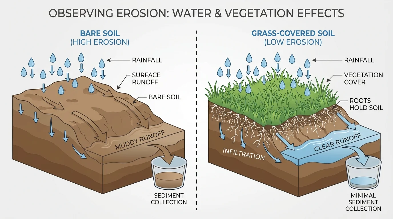
One important way to slow water erosion is with plants. Vegetation means plants growing in an area. As [Figure 3] helps show, plant roots can hold soil together, and leaves can soften the impact of falling rain. The grassy ground loses less soil because the roots help keep the soil in place.
Bare soil is easier for water to carry away. Soil covered by grass or other plants is often better protected. That is why hillsides, gardens, and stream edges are often planted to help reduce erosion.
Plants do not stop every kind of change, but they can slow the movement of soil. This is another example of Earth's systems interacting. Living things affect the land, and the movement of water affects both.
You may also notice that places with healthy plant cover often have less muddy runoff after light rain than places with bare dirt. That is because less soil gets picked up and carried away.
Good science uses both careful looking and careful measuring. If you see small channels in soil, roots sticking out, cloudy runoff, or a bank edge that has moved, those are clues. If you add numbers from rulers or measuring tapes, your evidence becomes stronger.
Scientists ask questions such as: What changed? How much did it change? When did it change? What likely caused the change? The answers come from observations and measurements, not guesses.
Suppose a shallow groove after rain measures \(3 \textrm{ cm}\) wide on the first day and \(9 \textrm{ cm}\) wide four days later. The change is \(9 - 3 = 6 \textrm{ cm}\). The average rate is \(\dfrac{6 \textrm{ cm}}{4 \textrm{ days}} = 1.5 \textrm{ cm/day}\). This simple number helps describe the erosion clearly.
Later, when you compare protected soil and bare soil, the idea from [Figure 3] helps explain why one place changes faster than another. A place with more plant cover often loses less soil during rainfall.
Evidence of erosion by water can come from many places: a streambank, a garden, a muddy path, or a schoolyard slope. Wherever moving water changes Earth's surface, observations and measurements help us understand what is happening.