A strong earthquake can shake a city in seconds, but the choices people make before it happens can save many lives. That is one of the most important ideas in Earth science: people cannot stop many natural Earth processes, but they can prepare for them and lower the damage. Smart planning, strong buildings, warning systems, and practiced safety actions all help humans live more safely on an active planet.
A natural hazard is a natural event that can harm people, homes, roads, schools, and the environment. A hazard becomes especially dangerous when many people live in the area or when people are not prepared. The same Earth process can cause only a little damage in one place and much more damage in another place, depending on where people live and what safety steps they have taken.
Earth is always changing. The ground can move. Water can rise. Waves can rush onto land. Magma can rise toward the surface and erupt from a volcano. These are natural parts of how Earth works. Humans cannot eliminate these hazards, but they can reduce risk, which means reducing the possibility that people and property will be harmed.
Hazard is something that can cause harm. Risk is the chance that the hazard will cause damage or injury. Impact means the effect the hazard has on people, places, and things.
When communities study hazards, they often ask questions such as: Where is this hazard most likely to happen? How strong could it be? How many people might be affected? What can we build, change, or practice now to stay safer later?
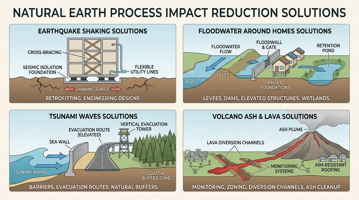
In this lesson, we focus on four hazards, as [Figure 1] shows: earthquakes, floods, tsunamis, and volcanic eruptions. Each hazard begins in a different way, so the best solutions are also different.
An earthquake happens when rocks in Earth suddenly shift and release energy. The ground shakes, and buildings, bridges, and roads can crack or fall. A flood happens when water covers land that is usually dry. Heavy rain, overflowing rivers, or fast snowmelt can all lead to floods. A tsunami is a series of large ocean waves, often caused by an underwater earthquake or volcanic event. A volcanic eruption happens when magma, ash, and gases reach Earth's surface.
Even though these hazards are different, they have something in common: communities can study them, prepare for them, and choose solutions that reduce harm.
Some solutions are used before a hazard starts, such as stronger buildings or hazard maps. Other solutions are used during the event, such as alarms, evacuation routes, or safety drills. The safest communities often use both kinds.
Some earthquake warning systems can send alerts just seconds before strong shaking arrives. That may sound short, but even a few seconds can help people move away from danger or take cover.
Those few seconds matter because preparation is often about small actions added together. A warning, a practiced drill, a safe meeting place, and a strong school building can work as a team.
Scientists observe Earth carefully, and [Figure 2] illustrates how information can move from monitoring tools to warnings that help people act quickly. They use instruments to measure shaking, watch river levels, track ocean waves, and monitor volcanoes for signs of change. Engineers then design structures and systems that help communities stay safer.
Monitoring means watching and measuring changes over time. For example, scientists may place sensors near faults to record ground movement, gauges near rivers to watch water level, or devices near volcanoes to measure heat, gases, and tiny earthquakes. Monitoring does not prevent the hazard, but it helps people understand what may happen next.
Warning systems send alerts when danger is detected. An alert may travel by siren, phone message, radio, television, or emergency broadcast. After a warning, people need to know what to do. That is why communities also create plans, routes, and drills.
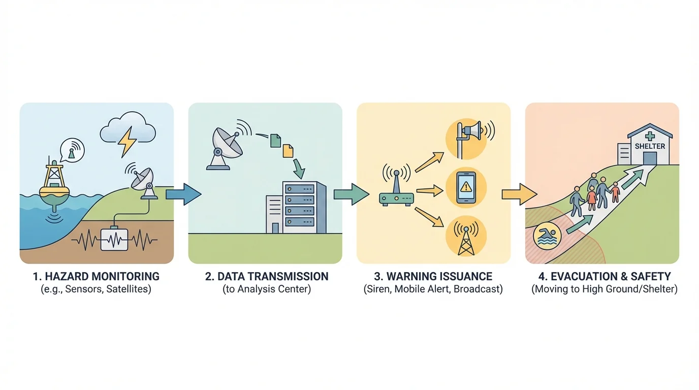
Engineers help by designing stronger buildings, safer roads, protective walls, and better drainage systems. Community leaders help by making rules about where people should build and by organizing evacuation plans. Families help by learning safety steps and keeping emergency supplies ready.
Reducing impact usually takes more than one solution. A single solution rarely protects everyone. A warning system is powerful, but it only works if people hear it and know where to go. A strong building helps, but it cannot protect people who live in unsafe areas nearby. The best protection often comes from combining science, engineering, planning, and practice.
That idea is important in every hazard we study. One answer is rarely enough. Communities compare several choices and often use a combination.
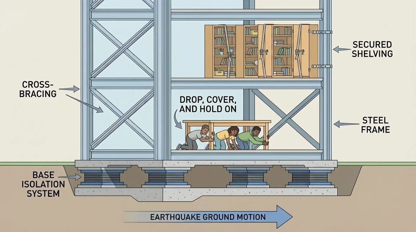
Earthquake safety depends on both structures and behavior, and [Figure 3] shows how safer buildings and safety actions work together. Because earthquakes strike suddenly, there may be little or no time to escape before shaking begins. That means preparation ahead of time is especially important.
One solution is to build structures that can handle shaking better. Engineers may use steel supports, cross-bracing, or special foundations that help buildings move without collapsing. Another solution is to secure heavy objects inside buildings. Shelves, televisions, bookcases, and lights can fall during shaking, so fastening them can prevent injuries.
A third solution is practicing drills. Students learn to drop, cover, and hold on. This is useful because trying to run during strong shaking can be dangerous. A fourth solution is keeping emergency kits with water, flashlights, batteries, and first-aid supplies.
Which earthquake solution is best? It depends on the question. Strong buildings protect many people, but they can cost a lot and take time to build. Safety drills are low-cost and quick to practice, but they do not strengthen old buildings. Securing furniture is cheaper than rebuilding a school, but it only solves part of the problem. Emergency kits help after the quake, but they do not stop injuries during the shaking.
Because each solution has strengths and limits, many communities use several at once. As seen earlier in [Figure 3], a safe building plus secured objects plus practiced drills gives better protection than only one of these solutions.
Case study: Choosing earthquake solutions for a school
Step 1: Identify the problem.
A school is in an area where strong earthquakes sometimes happen. The building is older, and tall shelves are in classrooms.
Step 2: List possible solutions.
The school can strengthen the building, bolt shelves to walls, practice earthquake drills, and prepare emergency kits.
Step 3: Compare the solutions.
Strengthening the building protects the whole structure but may cost the most. Bolting shelves is cheaper and faster. Drills help students respond safely. Kits help after the earthquake.
Step 4: Decide on the best plan.
The strongest plan is to use all four solutions, starting immediately with drills, shelf safety, and kits while larger building improvements are planned.
This example shows that comparing solutions does not always mean choosing only one. Sometimes the best answer is a sequence: do the quick, low-cost actions now and the bigger engineering work as soon as possible.
Floods can last longer than earthquakes, and the best protection often depends on land and water patterns, as [Figure 4] illustrates. In some places, rivers overflow after heavy rain. In other places, streets flood because the ground and drains cannot move water away fast enough.
One solution is to build levees or flood walls to keep rising water away from homes and roads. Another solution is to raise buildings so living spaces stay above likely floodwater. Communities can also protect wetlands, which soak up some extra water like giant natural sponges. Warning systems and flood maps also help people know when to move to safer places.
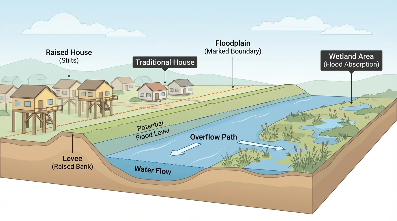
Some flood solutions are helpful but imperfect. A levee can reduce flooding in one area, but if water rises too high or the levee fails, flooding can still happen. Raised houses protect the people inside, but roads and yards may still flood. Wetlands are excellent for slowing water and helping wildlife, but they may not hold all the water in a very large storm.
Another important solution is deciding where to build. A floodplain is flat land near a river that can flood. Building fewer homes in floodplains can greatly reduce damage. This choice can be difficult because floodplain land may be useful or beautiful, but it can also be risky.
| Flood solution | What it does well | Limit |
|---|---|---|
| Levee or flood wall | Blocks water from some areas | May fail or be overtopped |
| Raised buildings | Keeps people and belongings higher | Does not stop all outside flooding |
| Wetlands | Absorb and slow some water | May not handle extreme flooding alone |
| Warnings and evacuation | Help people move to safety | Require time and good communication |
| Careful building locations | Reduces future damage | May limit where people can build |
Table 1. Comparison of common flood-reduction solutions and their strengths and limits.
Flood safety works best when communities mix natural solutions and built solutions. The town in [Figure 4] uses wetlands, raised buildings, and barriers because no single choice solves every flood problem.
As [Figure 5] shows, tsunamis can move across the ocean very fast, so quick action matters. Evacuation routes to higher ground are especially important. People living or visiting coastal areas need to know safe routes before a warning ever comes.
One major solution is a tsunami warning system. Scientists use ocean sensors and earthquake data to decide whether a tsunami may be coming. If danger is likely, warnings are sent out. Another solution is clear evacuation planning. Signs, maps, and practice drills help people move inland or to higher ground fast.
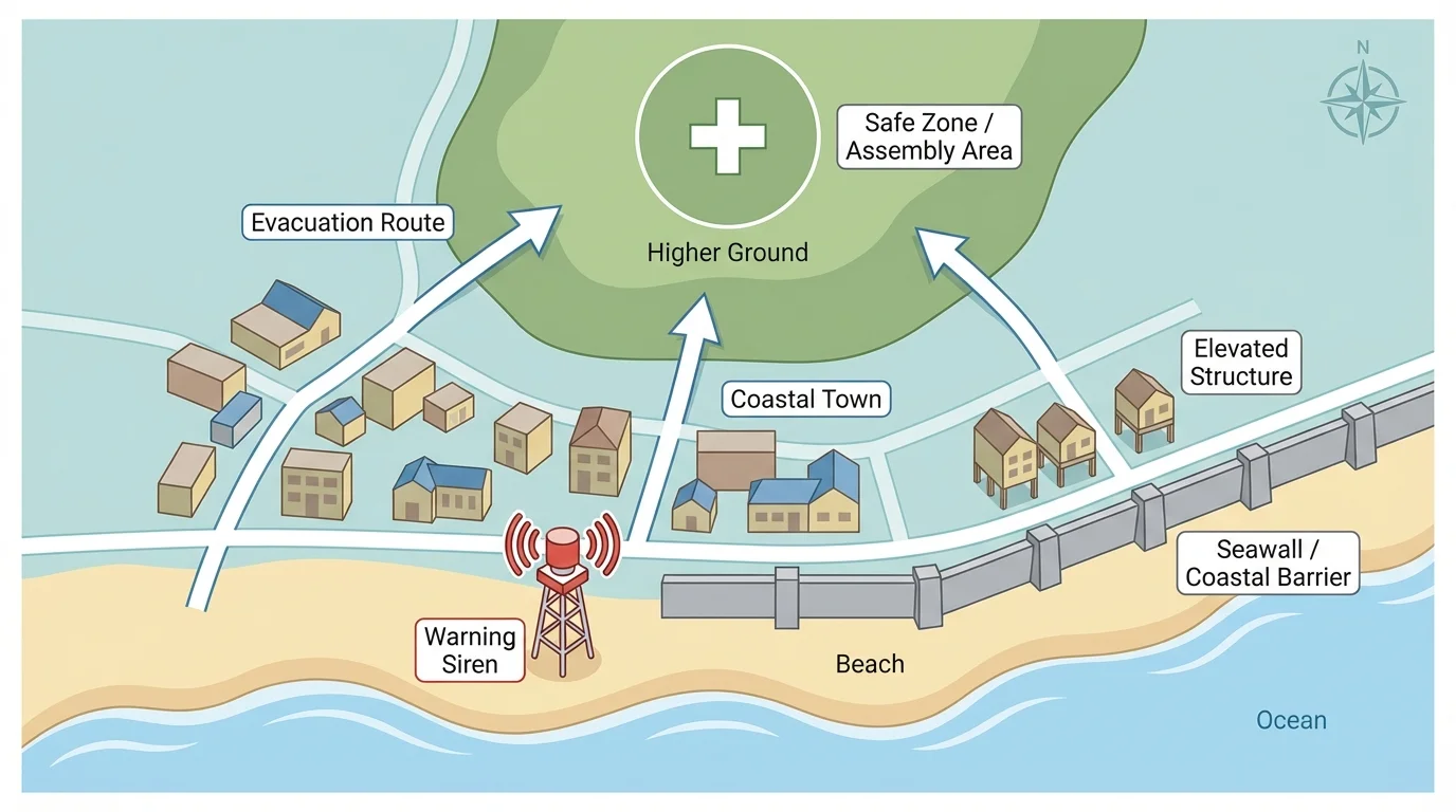
Communities can also make wise building choices near the coast. Important buildings like schools, hospitals, or emergency centers are safer when placed away from the highest-risk areas. In some places, strong vertical evacuation structures are built so people can climb high above wave level when there is not enough time to travel far.
Comparing tsunami solutions shows that speed is a major factor. A warning system is powerful, but if people do not understand the alert, it will not protect them. Evacuation drills are very useful, but they work best when routes are clear and easy to reach. Safer building placement helps all the time, but it must be planned before construction begins.
Water always moves downhill, and waves carry energy. Earlier learning about moving water helps explain why floods spread across low land and why tsunami waves can push far inland.
In coastal areas, natural clues matter too. If the ground shakes strongly near the ocean or the water suddenly pulls back from shore, people should move to high ground immediately, even before an official message arrives. That local action supports the formal warning system shown in [Figure 5].
Volcanoes may erupt with lava, ash, gases, or explosive blasts. Some eruptions build slowly, while others happen more suddenly. Because volcanoes often give warning signs, monitoring is especially valuable.
Scientists watch volcanoes for increased heat, gases, ground swelling, and small earthquakes nearby. If these signs increase, leaders may close dangerous areas and order evacuations. This creates an evacuation, which is an organized movement of people away from danger.
One solution is to create exclusion zones, which are areas where people are not allowed during dangerous times. Another solution is to plan evacuation routes so families can leave quickly. For ashfall, people may protect their lungs and eyes with masks and goggles, and communities may protect water supplies and machines from ash damage.
Case study: A town near a volcano
Step 1: Scientists notice change.
Instruments detect more small earthquakes, more gas, and swelling ground near the volcano.
Step 2: Officials compare solutions.
They consider waiting, closing nearby roads, warning residents, and evacuating the closest neighborhoods.
Step 3: They choose layered protection.
Officials close high-risk areas first, send alerts, prepare shelters, and evacuate people nearest the volcano.
Step 4: They adjust as conditions change.
If signs grow weaker, fewer actions may be needed. If signs grow stronger, a larger evacuation may happen.
This hazard shows clearly why solutions must match the situation. If lava moves slowly, people may have time to leave. If ash spreads widely, protecting air quality and transportation becomes more important.
Scientists and engineers often compare solutions using criteria. Criteria are the rules or standards used to judge how well something works. For natural hazards, useful criteria include safety, cost, speed, number of people protected, and effects on the environment.
For example, suppose a town compares two flood solutions: a levee and restoring wetlands. The levee may protect a neighborhood quickly, while wetlands may help over a broader area and support animals too. The best decision depends on what the town needs most and what limits it faces. Those limits are called constraints, such as money, land, or time.
Good comparisons use evidence. A strong answer does not just say, "I like this idea better." It explains why the solution is better for a certain place. Evidence may include land shape, distance from the coast, past flooding, building age, population size, or how fast a warning can be shared.
Sometimes students think the strongest structure is always the best answer. But a strong wall in the wrong place may help less than a warning system plus good routes plus smart land use. The goal is not to find a perfect solution. The goal is to find the most effective set of solutions for a real community.
In Japan, earthquake-resistant buildings and tsunami evacuation planning are very important because the country experiences both earthquakes and tsunamis. In places near large rivers, such as parts of the Mississippi River system in the United States, flood control and floodplain planning matter greatly. Near active volcanoes, such as in Hawaii or Iceland, monitoring and evacuation planning help protect communities.
These examples teach an important lesson: different places need different mixes of solutions. A coastal town may focus on tsunami routes and flood warnings. A city near a fault may focus on building safety and earthquake drills. A town near a volcano may focus on monitoring and exclusion zones.
Volcanic ash may look soft and light, but it can damage engines, scratch surfaces, and make breathing harder. That is why ash warnings and masks can be very important even far from flowing lava.
People also learn from past events. After a damaging hazard, communities often improve building rules, warning systems, and evacuation plans. Earth science is not only about understanding what happens in nature. It is also about using that understanding to protect lives.
The best community plans usually combine science, engineering, and teamwork. Scientists collect evidence. Engineers design solutions. Leaders make plans. Families learn what to do. Students practice drills and share safety knowledge at home.
When comparing multiple solutions, it helps to ask: Which solution protects the most people? Which one works fastest? Which one costs less? Which one protects nature too? Which one will still help if the hazard becomes stronger than expected?
Natural hazards are part of living on Earth, but disaster is not just about the hazard itself. It is also about whether people were prepared. Careful choices can turn a dangerous event into one with much less harm. That is why generating and comparing solutions is such an important part of science and engineering.