A giant lizard-like reptile once lived in freshwater, yet fossils of that animal have been found on continents now separated by a huge ocean. That is the kind of mystery that pushed scientists to ask a bold question: Have the continents moved? The answer is yes, and the evidence comes from several surprising places—rocks, fossils, the shapes of continents, and the hidden structures on the seafloor.
Earth's outer shell is broken into large pieces called plates. These plates move very slowly, usually only a few centimeters each year, but over millions of years that tiny motion adds up to enormous change. Oceans can open, mountains can rise, and continents can drift into new positions. This idea is called plate tectonics, and it is one of the most important ideas in Earth science because it helps explain Earth's changing surface and long geologic history.
Scientists do not guess where plates were in the past. They examine evidence and look for patterns. They compare fossils on different continents, test whether rock layers match, study how coastlines and continental shelves fit together, and map the seafloor. When these clues all point in the same direction, scientists can build a strong explanation for past plate motions.
Earth changes on many time scales. Some changes, like earthquakes, happen suddenly. Others, like the movement of tectonic plates, are so slow that people cannot watch them directly over a lifetime. That is why Earth scientists rely on evidence preserved in rocks, fossils, and landforms.
To understand past plate motions, it helps to think like a detective. A single clue may be interesting, but several matching clues make the case much stronger. A continent's shape might suggest a connection, but matching fossils and rock belts can support that idea much more strongly.
Scientists use several major kinds of evidence. First, they look at fossils, which are preserved remains or traces of ancient life. If the same land or freshwater species appears on continents now far apart, that may suggest those continents were once joined. Second, scientists compare rock layers and mountain belts. If rocks on two continents have the same age, type, and structure, they may have formed together before the continents separated.
Third, scientists examine the shape of continents. Some coastlines seem to fit together like puzzle pieces, especially around the Atlantic Ocean. Fourth, they study the seafloor. The ocean floor is not flat and featureless. It contains long mountain chains, deep trenches, and patterns in seafloor age that reveal motion over time.
Plate motion evidence is information preserved in Earth materials and landforms that helps scientists infer how tectonic plates moved in the past. Important evidence includes matching fossils, similar rocks and mountain ranges, the fit of continents, and structures on the ocean floor.
These clues are powerful because they come from different sources. Fossils provide biological evidence, rocks provide geologic evidence, continental shapes provide geographic evidence, and seafloor structures provide physical evidence of how plates behave today and behaved in the past.
One of the most convincing clues comes from fossil distribution. Scientists found the same ancient species on continents that are now widely separated by oceans. This pattern is difficult to explain if the continents were always in their present locations.
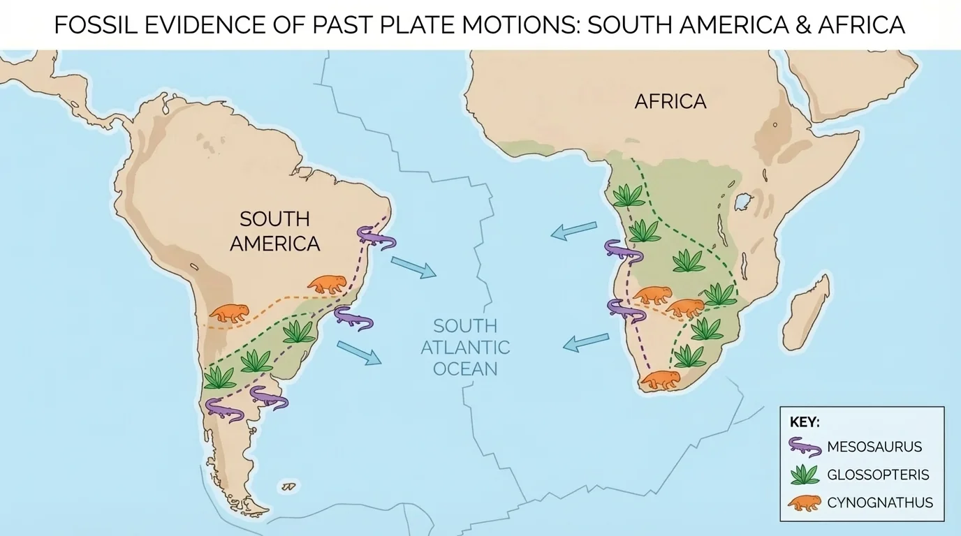
For example, fossils of Mesosaurus, a small reptile that lived in freshwater, have been found in both South America and Africa, as [Figure 1] shows. It is unlikely that a freshwater reptile crossed a wide saltwater ocean. A much better explanation is that South America and Africa were once joined, and the animal lived across a connected land area before the continents separated.
Other fossils tell a similar story. The seed fern Glossopteris has been found in South America, Africa, India, Antarctica, and Australia. Fossils of the land reptile Lystrosaurus appear in Africa, India, and Antarctica. Since these organisms could not travel across vast oceans in the way modern ships do, the fossil pattern suggests that these continents were once connected in the ancient supercontinent Gondwana.
Fossils do more than show connection. They also help scientists infer climate and environment. For instance, plant fossils found in Antarctica suggest that it was once warmer and located in a different position than it is today. This supports the idea that continents have moved over time rather than staying fixed.
Case study: Why Mesosaurus matters
Step 1: Scientists identify where fossils are found.
Mesosaurus fossils occur in eastern South America and western Africa.
Step 2: They ask whether the organism could cross the present-day ocean.
A freshwater reptile was not adapted to travel across the Atlantic Ocean.
Step 3: They compare explanations.
The explanation that the continents were once connected fits the evidence better than the idea that the reptile crossed a huge ocean.
This is an example of scientists choosing the explanation that best matches the available evidence.
Later evidence from rocks and seafloor structures supports the same conclusion. That matters because science is strongest when different types of data agree. The fossil map in [Figure 1] is convincing not just because fossils match, but because other clues match too.
Geologists also compare mountain belts and rock formations on different continents. If continents were once connected, rock patterns should continue from one continent to another like pieces of a torn map.
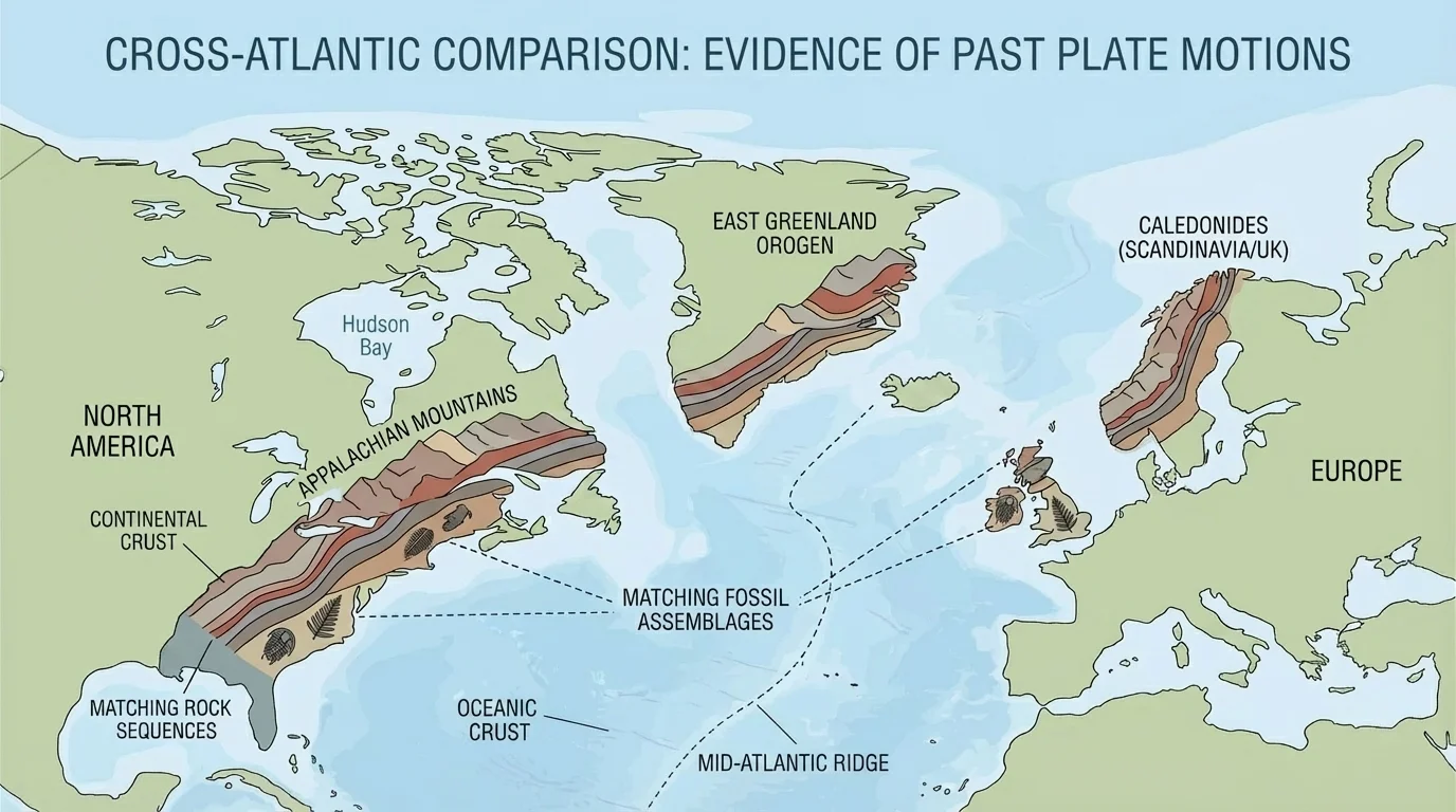
This is exactly what scientists have found. As [Figure 2] shows, parts of the Appalachian Mountains in eastern North America match mountain belts in Greenland and Europe. The rocks have similar ages, structures, and histories. When the continents are placed back together, these mountain systems line up much more naturally.
Matching rocks are not only about mountains. Layers of the same rock type and age can appear on coasts now separated by oceans. If one continent has a certain sequence of sandstone, shale, and volcanic rock, and another continent has the same sequence in the matching position, that is strong evidence that the two were once joined.
Scientists analyze rock evidence carefully. They examine mineral content, layer order, folding, and age. Suppose two rock units on different continents both formed about the same time, contain similar minerals, and show the same pattern of bending and compression. That makes random coincidence unlikely.
| Type of rock evidence | What scientists compare | What it suggests |
|---|---|---|
| Rock age | Whether rock units formed at the same time | Possible shared geologic history |
| Rock type | Whether materials are similar, such as sandstone or granite | Similar formation conditions |
| Layer sequence | Whether layers appear in the same order | Former connection of land areas |
| Mountain structure | Whether folds and faults line up | Mountains formed before continents separated |
Table 1. Geologic comparisons scientists use when matching rocks and mountain belts across continents.
The rock evidence in [Figure 2] is important because mountains do not form as isolated decorations on each continent. They form through powerful plate interactions. When matching mountain belts appear on continents now separated by ocean, they suggest those continents were once part of the same larger landmass.
Long before modern satellites and seafloor maps, people noticed that some continents seemed to fit together. South America and Africa are the classic example, and the fit is better when scientists compare the edges of the continental shelves instead of the modern shorelines.
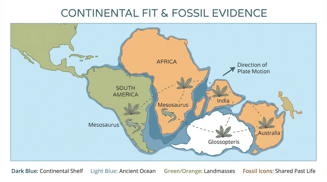
This clue helped launch the idea of continental drift, proposed by Alfred Wegener in the early 1900s. As [Figure 3] shows, he argued that today's continents were once joined in a supercontinent called Pangaea. At first, many scientists were not convinced because he did not yet have enough evidence to explain how the continents moved. Later discoveries about plate tectonics and the seafloor provided that missing support.
The shape clue is useful, but by itself it is not enough. Coastlines change over time because of erosion, deposition, sea-level changes, and storms. That is why scientists compare the continental shelf, the shallow underwater edge of a continent, rather than only the coastline we see above water. The shelf edge often gives a better picture of the continent's true boundary.
Alfred Wegener was trained in meteorology, not geology. Even though many scientists first rejected his ideas, several of his observations about matching continents, fossils, and rocks turned out to be correct.
When the continents are fitted together using shelf boundaries, the match improves. But scientists still do not rely on shape alone. The best explanations come from combining this clue with fossils, rocks, and seafloor data. That is why the continental fit in [Figure 3] is best treated as one piece of a larger evidence puzzle.
The seafloor provides some of the strongest modern evidence for plate motion. The ocean floor contains long underwater mountain chains called mid-ocean ridges, where new crust forms, and deep trenches where crust is forced downward into the mantle. These structures show that the ocean floor is active, not still.
At a mid-ocean ridge, molten material from inside Earth rises, cools, and forms new oceanic crust. As [Figure 4] shows, new crust forms while older crust is pushed away on both sides. This process is called seafloor spreading. The youngest rocks on the ocean floor are found near the ridge, while older rocks are found farther away.
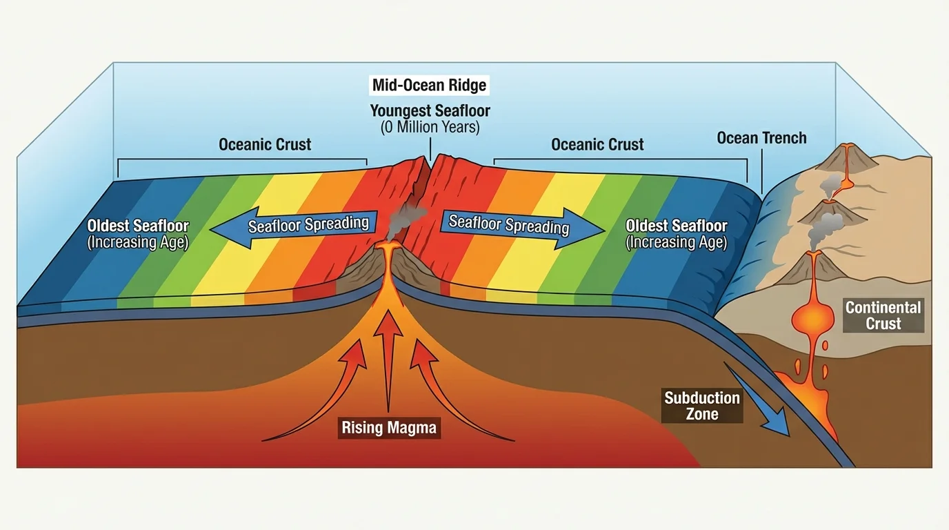
This age pattern matters because it shows motion. If new crust keeps forming at the ridge and moves outward, then plates must be separating there. On the other hand, at trenches, one plate can sink beneath another into the mantle. This process helps explain how Earth can create new crust in one place and recycle crust in another.
Seafloor structures also connect to real events people experience. Many earthquakes and volcanoes happen near plate boundaries. Mid-ocean ridges, trenches, and subduction zones are not random features. They are part of a moving system. By mapping these structures, scientists can understand both present-day plate behavior and past plate motions.
Why seafloor evidence changed Earth science
When scientists mapped the ocean floor in detail, they discovered that it had patterns too organized to be accidental. Mid-ocean ridges, deep trenches, and systematic seafloor ages made sense if plates move. This evidence helped transform continental drift from an interesting idea into the modern theory of plate tectonics.
The seafloor pattern in [Figure 4] also explains why oceans can grow wider. If spreading continues for millions of years, continents on opposite sides of an ocean move farther apart. That is one reason the Atlantic Ocean exists between South America and Africa today.
Scientific explanations become stronger when different lines of evidence agree. Matching fossils suggest continents were once connected. Matching rock layers and mountain belts show that geologic structures continue across oceans. Continental shapes hint at how landmasses fit together. Seafloor ridges and trenches show a mechanism for movement.
When scientists combine these clues, they can reconstruct the positions of continents in the past. They infer that Pangaea formed hundreds of millions of years ago and later broke apart. The southern continents were once part of Gondwana, which helps explain why fossils such as Glossopteris are spread across landmasses now separated by vast oceans.
How scientists build an explanation from multiple clues
Step 1: Observe patterns.
Similar fossils, matching rocks, and aligned mountain belts appear on separate continents.
Step 2: Test whether the continents fit together.
The continental shelves fit more closely than modern coastlines.
Step 3: Check the seafloor.
Mid-ocean ridges and the age pattern of the seafloor show where new crust forms and spreads.
Step 4: Choose the explanation that fits all clues.
Plate motion explains the fossil, rock, shape, and seafloor evidence together better than the idea of fixed continents.
This is why plate tectonics is called a unifying theory: it brings many kinds of observations into one explanation.
A good scientist also asks whether another explanation could fit the evidence. For example, could similar fossils on different continents be explained by separate evolution? Sometimes, but that would not explain the matching rocks, mountain belts, and continental fit as well. The best explanation is the one that accounts for the most evidence with the fewest contradictions.
Understanding past plate motions is not just about ancient history. It helps scientists predict where earthquakes and volcanoes are most likely, locate certain mineral and energy resources, and understand how mountain ranges and ocean basins formed. Engineers, hazard planners, and geologists all use knowledge of plate boundaries in their work.
For example, when scientists know that a region formed where plates collided, they expect to find folded rocks, faults, and sometimes earthquake risk. When they know a coastline separated from another continent long ago, they can compare rock layers on both sides of the ocean to search for similar resources. Evidence from the past helps solve problems in the present.
The same evidence also tells a bigger story about Earth: our planet is dynamic. The ground beneath us may feel solid and unmoving, but over geologic time it behaves more like a slowly shifting puzzle. Fossils in Antarctica, matching mountain belts across oceans, and active ridges deep underwater all reveal that Earth's surface never stays the same forever.
"The present is the key to the past."
— A guiding idea in geology
That idea matters here because scientists observe plate motion and seafloor activity today, then use those observations to interpret clues preserved from long ago. By analyzing fossil distribution, rock evidence, continental shapes, and seafloor structures, they can reconstruct how plates moved and how Earth's surface became what we see now.