Your phone, your lights, the water from a faucet, and even the metal in a bicycle all depend on resources from Earth. But those resources are not scattered evenly like toppings on a pizza. Some regions have rich iron deposits, some have large oil fields, some have thick aquifers underground, and some have very little of these things. This pattern is not random. It is the result of Earth's long history and the processes still shaping the planet today.
Earth is active. Continents move, volcanoes erupt, mountains rise, rocks break down, rivers carry sediment, and water moves through soil and rock. Over millions of years, these processes sort, concentrate, bury, heat, crack, dissolve, and transport materials. That is why one place may have copper, another may have coal, and another may store huge amounts of groundwater.
To make sense of this, scientists build explanations from evidence. They study rocks, fossils, maps, drilling records, satellite images, water levels, and chemical clues. Then they connect that evidence to geoscience processes such as plate tectonics, erosion, deposition, and the water cycle.
A resource is something from Earth that people use. Three important groups are minerals, energy resources, and water resources.
Mineral resources include useful materials found in rocks and sediments, such as iron, copper, gold, salt, limestone, and sand. Some minerals are used to make buildings, roads, and glass. Others are used in wires, batteries, electronics, and machines.
Energy resources provide power. These include coal, oil, natural gas, uranium, and geothermal energy. Some energy resources are nonrenewable, which means they form so slowly that people use them much faster than Earth replaces them. Fossil fuels and uranium are examples.
Groundwater is water stored underground in pore spaces within soil and sediment or in cracks in rock. In many places, it supplies drinking water, farm irrigation, and water for industry.
Rocks are constantly changing through the rock cycle. Igneous rocks form from cooled magma or lava, sedimentary rocks form from compacted sediments, and metamorphic rocks form when heat and pressure change existing rock. These rock changes are closely tied to where many resources are found.
People depend on these resources every day, but Earth does not place them equally in every region. To understand why, we need to look at both the evidence and the processes that shape the planet.
In science, an explanation is stronger when it is based on evidence, not just opinion. A scientific explanation usually includes three parts: a claim, evidence, and reasoning. The claim answers a question. The evidence gives facts or observations. The reasoning explains why the evidence supports the claim.
For example, suppose scientists claim that a region has large copper deposits because it formed near an ancient volcanic plate boundary. Their evidence might include volcanic rocks, metal-rich veins, earthquake patterns, and the ages of nearby rocks. Their reasoning would connect these clues to magma and hot fluids that concentrated copper underground.
Plate tectonics is the theory that Earth's outer shell is broken into moving plates. Deposition is the laying down of sediment by water, wind, ice, or gravity. An aquifer is a body of rock or sediment that stores and allows groundwater to move.
Scientists often use several kinds of evidence together because one clue alone may not be enough. A rock sample, a map of faults, and chemical tests may all point to the same explanation. This is how geologists explain uneven resource distribution.
Many important mineral resources are concentrated by plate tectonics, especially near plate boundaries. When plates move, they create volcanoes, mountain ranges, cracks, pressure, and heat. These conditions help gather minerals into deposits large enough for people to mine.
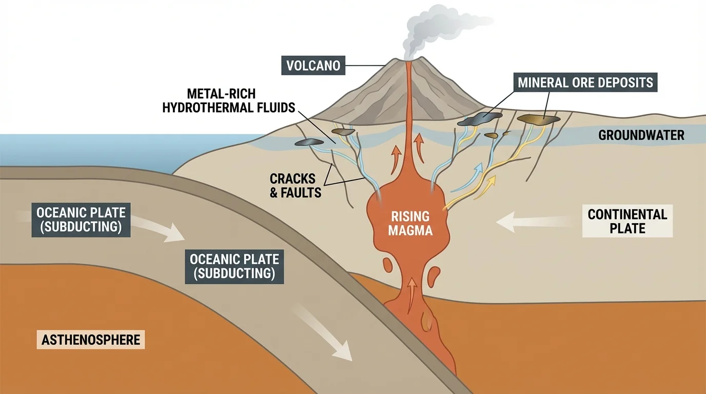
At a convergent boundary, one plate may sink beneath another in a process called subduction. As the sinking plate goes deeper, rock melts and forms magma. The magma rises and can heat underground water. This hot, mineral-rich water moves through cracks in rock. As it cools, it leaves behind minerals such as copper, gold, silver, and zinc. These concentrated materials are called ore deposits.
This matters because metals are not usually spread evenly through rock. A huge amount of ordinary rock may contain only a tiny amount of metal. Geologic processes must concentrate that metal enough to make mining possible. As shown in [Figure 1], plate boundaries are some of the best places for this concentration to happen.
Volcanic regions are not the only places where minerals collect. Mountain building can squeeze and change rocks through heat and pressure. This can form metamorphic rocks and sometimes move minerals into veins. In other places, evaporating seawater leaves behind thick deposits of salt, gypsum, and other minerals. Rivers can also sort heavy minerals, such as gold, into certain sediments.
Iron is another good example. Some major iron deposits formed in ancient oceans long ago, when dissolved iron in seawater reacted with oxygen and settled to the bottom. Over time, these layers became rock. That means Earth's atmosphere, oceans, and early life also influenced resource distribution.
Some of the metals used in phones and computers came from ore deposits created by volcanic and tectonic activity hundreds of millions of years ago. Modern technology often depends on very ancient geologic events.
Later in a region's history, weathering and erosion can expose mineral deposits near the surface, making them easier to find and mine. In that way, older tectonic events create the deposit, and newer surface processes help reveal it. This is one reason geologists consider both past and present processes.
Fossil fuels do not form everywhere. They form only where ancient environments, burial, heat, and pressure were just right. That is why some places have large oil and gas fields while others do not.
Coal forms mainly from the remains of plants that built up in ancient swamps. If dead plants pile up in wet, low-oxygen conditions, they decay slowly. Over long periods, layers of sediment bury them. Heat and pressure change the plant material into coal. Regions that were once swampy and later buried under sediment are more likely to contain coal deposits.
Oil and natural gas usually form from tiny marine organisms, such as plankton, buried in seafloor mud. As more sediment piles on top, temperature and pressure increase. Over millions of years, the buried organic matter changes into hydrocarbons. These fluids can then move through porous rocks and become trapped beneath less permeable rock layers.
The temperature increase with depth can be described simply by a geothermal gradient. For example, if temperature rises by about \(25^\circ\textrm{C}\) for each \(1 \textrm{ km}\) of depth, then rock buried \(3 \textrm{ km}\) deeper may be about \(75^\circ\textrm{C}\) hotter. That extra heat helps transform buried organic material into oil or gas.

Scientists look for evidence such as sedimentary rock layers, ancient marine fossils, rock porosity, underground traps, and seismic data to explain where oil and gas are likely to occur. This is another example of constructing explanations from evidence rather than guessing.
Not all energy resources come from buried life. Uranium is a mineral resource used for nuclear energy, and it is found in certain rock types and geologic settings. Geothermal energy depends on Earth's internal heat and is strongest in places with active tectonics, such as volcanic regions. Moving plates help create the conditions for some valuable energy resources too.
Case study: why one basin has oil and another does not
Step 1: Identify the ancient environment.
Basin A was once a shallow sea rich in tiny organisms. Basin B was mostly exposed dry land.
Step 2: Check burial conditions.
In Basin A, thick sediments buried organic matter deeply. In Basin B, little sediment accumulated.
Step 3: Look for heat, pressure, and traps.
Basin A reached the right temperatures and had porous rock capped by impermeable layers. Basin B did not.
A scientific explanation would conclude that Basin A is much more likely to contain oil or natural gas because the evidence matches the known geologic conditions needed for formation and trapping.
These examples show that energy resources depend on very specific conditions in Earth's past. Ancient swamps, seafloors, burial depths, and tectonic settings all matter.
Unlike a lake on the surface, groundwater is usually hidden in tiny spaces underground, and its distribution depends strongly on rock properties and climate. Some rocks can store and transmit lots of water. Others block it almost completely.
Two important ideas are porosity and permeability. Porosity is the amount of open space in a material. Permeability is how easily water can move through those spaces. A rock may have many pores but still have poor connections between them, so water cannot flow well.
Sand and sandstone often make good aquifers because they can have useful pore spaces and connected pathways. Clay usually has tiny spaces that hold water tightly, so it is much less permeable. Fractured limestone can also store large amounts of groundwater because water enlarges cracks over time.
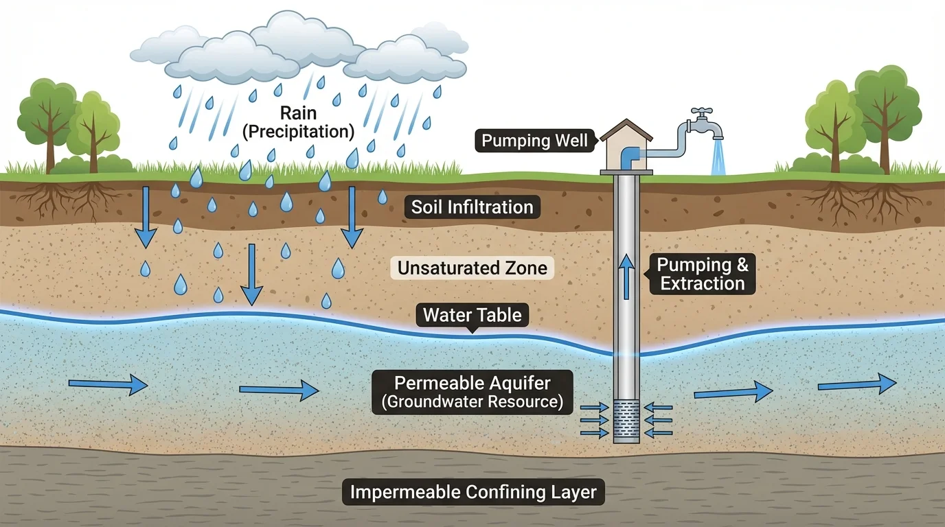
Groundwater is recharged when rain or melted snow soaks into the ground. The top of the saturated zone is called the water table. If people pump water out faster than it is replaced, the water table can drop. This can make wells run dry and can even cause land to sink in some regions.
Climate is also important. Wet areas may recharge aquifers often, while deserts recharge slowly. That means two places with similar rock types may still have different groundwater supplies because of different rainfall patterns. In some regions, groundwater stored today entered the ground thousands of years ago during a wetter climate.
Why groundwater is unevenly distributed
Groundwater depends on several factors working together: the kind of rock or sediment underground, the presence of cracks or open spaces, the amount of rainfall, the slope of the land, and whether water can recharge faster than it is removed. Because these conditions vary from place to place, groundwater resources are uneven across Earth.
Scientists gather evidence from well depth, pumping tests, underground maps, and water chemistry to explain how aquifers formed and how they behave. Layers that let water move and layers that block water control where groundwater can collect.
It is tempting to think that resources are controlled only by ancient events, but present-day processes matter too. The uneven distribution of resources is the result of both past and current geoscience processes.
Past processes may create the resource. For example, tectonic activity can produce a copper deposit, and ancient swamps can create coal. Current processes may change access to that resource. Weathering can break down overlying rock, erosion can expose buried material, landslides can cover it, and groundwater flow can dissolve and move minerals.
Rivers constantly sort sediments by size and weight. This can concentrate dense minerals in certain streambeds. Coastal waves can reshape sand deposits. Desert winds can move and pile sediments. These newer processes do not usually create metals from nothing, but they can move and concentrate useful materials into places where humans can collect them more easily.
The water cycle is another current process. Water evaporates, condenses, falls as precipitation, runs off, and infiltrates the ground. Groundwater supplies depend on this ongoing cycle. If climate changes, recharge rates may change too, affecting how much groundwater is available.
| Resource type | Main geoscience processes | Why distribution is uneven |
|---|---|---|
| Mineral resources | Plate movement, volcanism, hydrothermal activity, metamorphism, evaporation, erosion | Only certain geologic settings concentrate minerals into mineable deposits |
| Energy resources | Burial of organic matter, sedimentation, heat, pressure, rock trapping, tectonic activity | Only some regions had the right ancient environments and burial histories |
| Groundwater | Infiltration, recharge, rock formation, fracturing, dissolution, climate patterns | Rock type, pore space, permeability, and rainfall vary from place to place |
Table 1. Comparison of how major geoscience processes affect different kinds of Earth resources.
Because resources are unevenly distributed, people and countries do not all have the same access to them. Some regions export oil, metals, or groundwater-intensive crops, while others must import what they need. This can affect economics, technology, and even international relationships.
Many important resources are limited. A deposit may be large, but it is not endless. If a resource takes millions of years to form and humans use it quickly, it is nonrenewable on a human time scale. Groundwater can be renewable in some places, but only if recharge keeps pace with use.
Real-world application: making decisions about groundwater use
Step 1: Measure water entering the aquifer.
Suppose rainfall and infiltration recharge an aquifer by \(2 \textrm{ cm}\) per year.
Step 2: Compare that with water removed.
If pumping lowers stored groundwater by the equivalent of \(5 \textrm{ cm}\) per year, then removal is greater than recharge.
Step 3: Explain the outcome.
Because \(5 - 2 = 3\), the aquifer loses the equivalent of \(3 \textrm{ cm}\) of stored water each year. Over time, the water table will likely drop.
Such evidence helps communities decide whether water use is sustainable.
Mining, drilling, and pumping also have environmental effects. Mining can disturb land and release pollutants. Oil and gas extraction can affect ecosystems and water quality. Excessive groundwater pumping can dry wetlands or reduce stream flow. Good resource management depends on understanding where resources came from and how quickly they can be replaced.
When you construct a scientific explanation, start with a clear claim. Then add evidence from observations or data. Finally, explain the geoscience process that connects the evidence to the claim.
A strong explanation might sound like this: Mineral deposits in this region are unevenly distributed because the area formed near an ancient convergent plate boundary. Evidence includes volcanic rocks, faulted mountains, and copper-rich veins in rock samples. These features show that magma and hot fluids moved through cracks and concentrated metals underground.
Another explanation could focus on groundwater: This valley has more groundwater than the nearby hills because it contains thick layers of permeable sand and gravel, receives recharge from seasonal rains, and has an impermeable layer beneath the aquifer. Evidence includes well records, water table maps, and the types of sediments found underground.
Notice that these explanations do more than say where a resource is. They explain why it is there, using evidence and Earth processes. That is the heart of geoscience.
"The present is the key to the past."
— A guiding idea in geology
This famous idea means that by studying processes happening now, such as erosion, volcanism, and groundwater flow, scientists can better understand how resources formed long ago. It also works the other way around: by studying Earth's past, we can make smarter choices about using resources today.