Why is one place covered in rainforest, another in desert, and another in ice, even though all three are on the same planet? The answer begins with a surprising idea: Earth does not receive the same amount of solar heating everywhere. That uneven heating, together with Earth's rotation, helps create large patterns of atmospheric and oceanic circulation. Those patterns shape the climates people experience, from humid tropical afternoons to cool, foggy coasts to dry inland regions.
Climate is the usual pattern of temperature, rainfall, wind, and other weather conditions in a place over a long time. Weather can change from day to day, but climate describes the bigger pattern. If you compare northern Canada, the Amazon rainforest, and the Sahara Desert, you can see that Earth has strong regional differences. Scientists explain these differences by building models of how energy and matter move through the Earth system.
A model in science is a simplified way to represent something complicated. A globe is a model of Earth. A diagram of moving air is also a model. Models do not include every detail, but they help us explain important patterns. In this lesson, the model links sunlight, heating, air movement, ocean movement, and climate.
Climate is the long-term pattern of weather in a region. Atmospheric circulation is the large-scale movement of air around Earth. Oceanic circulation is the large-scale movement of ocean water, both at the surface and in deeper layers.
To understand climate, it helps to remember that Earth is a system. The atmosphere, oceans, land, ice, and living things all interact. Water cycles among ocean, land, and atmosphere, powered mainly by sunlight and gravity. As water evaporates, condenses, falls as precipitation, flows downhill, freezes, or melts, it transfers energy and changes Earth's surface.
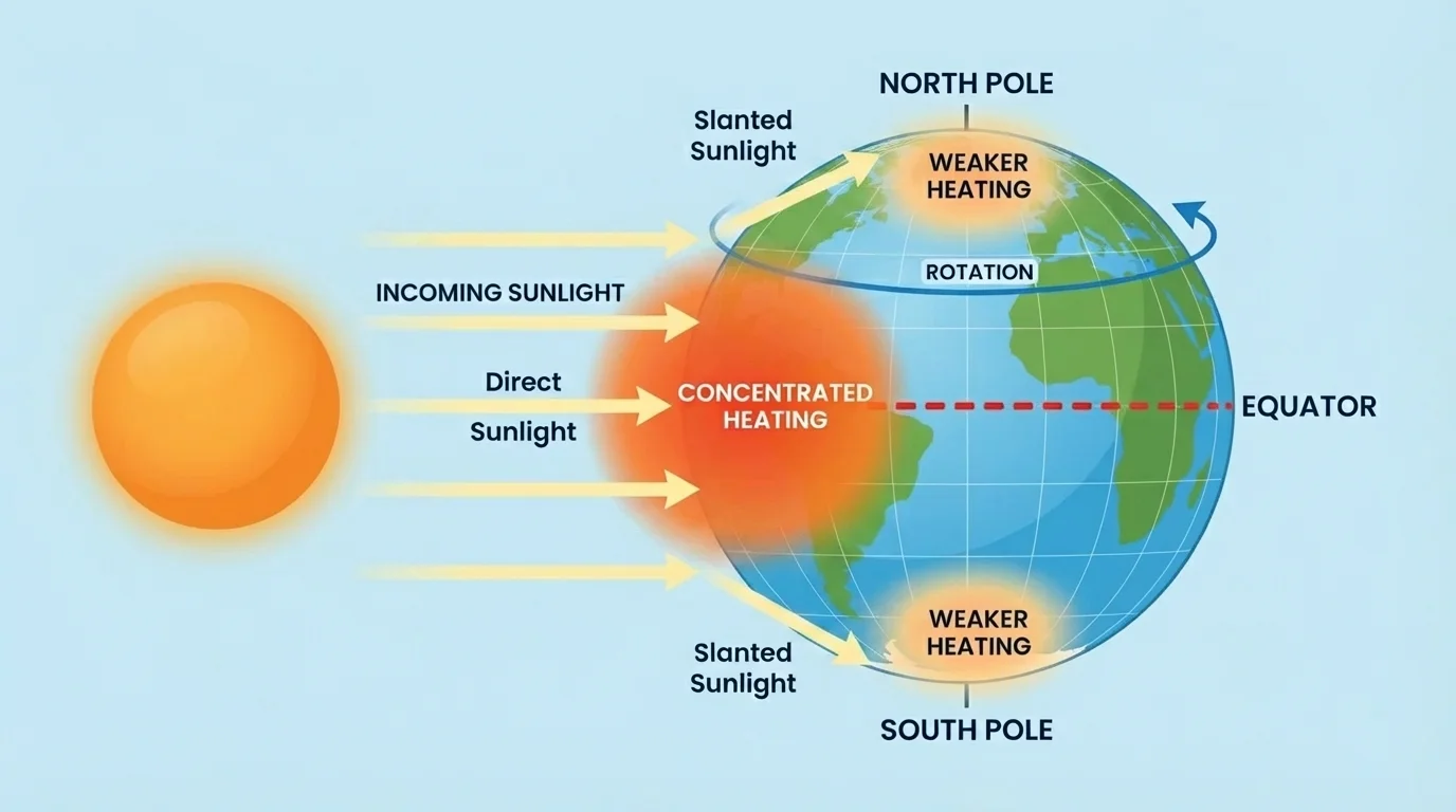
[Figure 1] The first part of the model is unequal heating. Earth is curved, so sunlight hits different places at different angles. Near the equator, sunlight is more direct and concentrated, as [Figure 1] shows. Near the poles, sunlight arrives at a lower angle and spreads over a larger area, so each square meter gets less energy.
This difference matters because concentrated energy causes stronger heating. If the same amount of light is spread out, the surface warms less. That is one major reason tropical regions are generally warmer than polar regions. Seasons add another layer because Earth's axis is tilted, but even without focusing on seasons, the equator-to-pole energy difference is enough to begin the global circulation pattern.
Land and water also heat differently. Land usually warms and cools faster than water. Water takes more energy to change temperature, so oceans change temperature more slowly. This is why coastal places often have milder climates than inland places. During summer, the ocean may stay cooler than nearby land. During winter, the ocean may stay warmer than nearby land.
Because the ocean stores heat and releases it slowly, it acts like a huge energy reservoir. That stored energy affects nearby air and can influence weather and climate far from the shore. This is one reason oceans are so important in Earth's climate system.
The equator does not receive more hours in a day than the poles every day of the year, but it usually receives more concentrated solar energy. That concentration makes a big difference in heating.
Unequal heating creates temperature differences, and temperature differences lead to movement. Warm air and warm water behave differently from cool air and cool water. Once parts of the Earth system are warmed more than others, energy starts moving from warmer regions toward cooler regions.
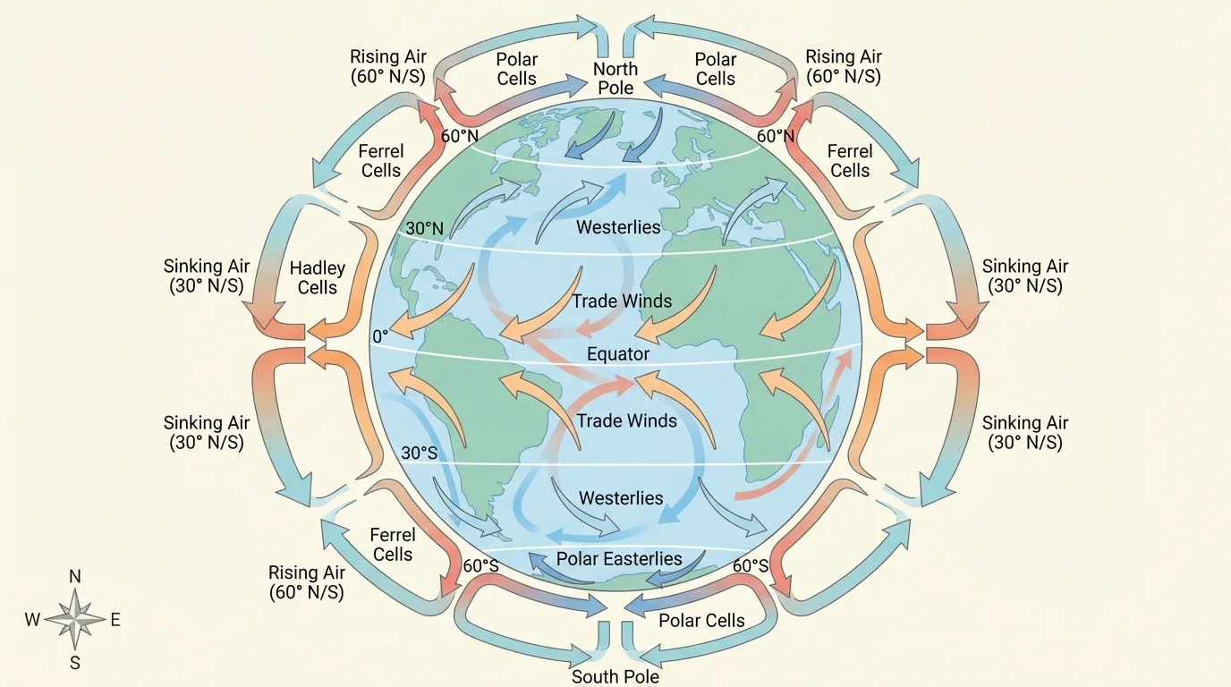
[Figure 2] A useful model for this topic has four connected ideas. First, the Sun heats Earth unevenly. Second, warm air rises and cool air sinks, creating broad patterns of moving air. Third, winds push surface ocean water, while differences in water density move deep ocean water. Fourth, these circulation patterns affect temperature and precipitation in different regions, helping determine climate.
This model is not a copy of every detail in the real world. Mountains, coastlines, seasons, and storms all add complexity. Even so, the model is powerful because it explains large repeating patterns seen around the globe. Scientists often start with simple models and then improve them when they add more evidence.
Cause-and-effect chain in the climate system
More direct sunlight causes stronger heating. Stronger heating causes some air to warm, expand, and rise. Rising air and sinking air create large-scale circulation. Winds linked to that circulation help move surface ocean water. Temperature and salinity differences change seawater density, which moves deeper ocean water. Together, these motions transfer heat and moisture, leading to regional patterns of wetness, dryness, warmth, and cold.
When you use a model, you are not just naming parts. You are tracing relationships. For example, if a region has warm ocean water nearby, the model suggests more evaporation may occur. More evaporation can add moisture to the air. Moist air can later cool, condense, and produce clouds or rain. That chain helps explain why some coasts are wet and others are dry.
Air movement begins because warm air is less dense than cool air. In the broad circulation model, strongly heated air near the equator rises, while cooler air in other regions sinks. This rising and sinking creates large loops of air movement in the atmosphere.
When air rises near the equator, it expands and cools. As it cools, water vapor can condense into clouds and precipitation. That is one reason many equatorial regions are rainy. After rising, the air spreads out at higher altitudes and eventually sinks in regions farther from the equator, especially around the subtropics. Sinking air tends to warm and dry out, which helps explain why many desert regions are found in those latitudes.
Farther toward the poles, air circulation continues in broad bands. The exact motion of winds around the rotating Earth is complex, but for this level, the key idea is that Earth's rotation helps organize moving air into major global wind patterns. You do not need the details of the Coriolis effect to understand the main result: Earth has repeating belts of air movement that help transport heat and moisture.
These circulation patterns matter because moving air transports energy. Without circulation, the tropics would keep gaining heat while the poles would stay much colder. The atmosphere helps balance Earth by moving heat from warmer places toward cooler places.
The atmosphere also moves moisture. Winds can carry water vapor from the ocean onto land. If that moist air rises over a mountain, cools, and condenses, one side of the mountain may get much more rain than the other. This shows that global circulation sets up broad patterns, while local features such as mountains shape smaller regional differences.
Warm air rises and cool air sinks because density changes with temperature. You may have seen this idea before in convection currents, where heated fluid rises and cooler fluid sinks.
A simple way to picture this is to think of a pot of soup being heated from below. The warmer soup rises and cooler soup sinks, creating circulation. Earth's atmosphere is much more complicated than soup, but the basic idea of convection still helps explain the movement.
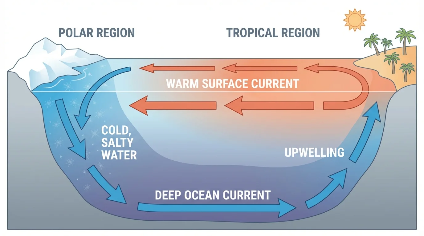
[Figure 3] The ocean is not still water. It is constantly moving in connected patterns. Some of this motion happens at the surface, and some happens in deep water. Surface currents are mainly pushed by wind patterns, while deep currents are strongly influenced by differences in water density.
[Figure 3] Density is how much matter is packed into a certain volume. Colder seawater is usually denser than warmer seawater. Saltier seawater is also denser than less salty seawater. In some polar regions, ocean water becomes very cold and very salty, so it sinks. That sinking helps drive deep ocean circulation.
This connection between temperature, salinity, and density is sometimes described with a simple relationship: as temperature decreases or salinity increases, density tends to increase. For example, if one water mass has a temperature of about \(5 \, \textrm{°C}\) and another has a temperature of about \(20 \, \textrm{°C}\), the colder water is generally denser. If the colder water is also saltier, the density difference becomes even greater, making sinking more likely.
Because deep water moves slowly, ocean circulation can transfer heat over very long distances and times. Warm surface currents can make nearby land warmer and wetter than other places at the same latitude. Cold currents can cool nearby coasts and may reduce evaporation, helping create dry coastal climates in some areas.
Surface and deep circulation are connected. Winds move the surface, and density differences move deeper layers. Together, the oceans act as a giant heat transport system. This helps explain why Earth's climate is not determined only by latitude.
Real-world example: why some water sinks
Think about two containers of seawater. Container A is warmer and less salty. Container B is colder and saltier.
Step 1: Compare temperature
Colder water has particles moving more slowly and packed slightly closer together, so it is usually denser than warmer water.
Step 2: Compare salinity
Salt dissolved in water adds mass. Higher salinity usually increases density.
Step 3: Predict movement
Because Container B is both colder and saltier, it is likely denser and more likely to sink below Container A if the two water masses meet.
This same idea helps explain deep ocean circulation in parts of the real ocean.
Ocean circulation also affects living things. Nutrients can be brought upward by certain currents, supporting plankton, fish, and larger marine animals. That means circulation patterns influence ecosystems, fishing, and even human economies.
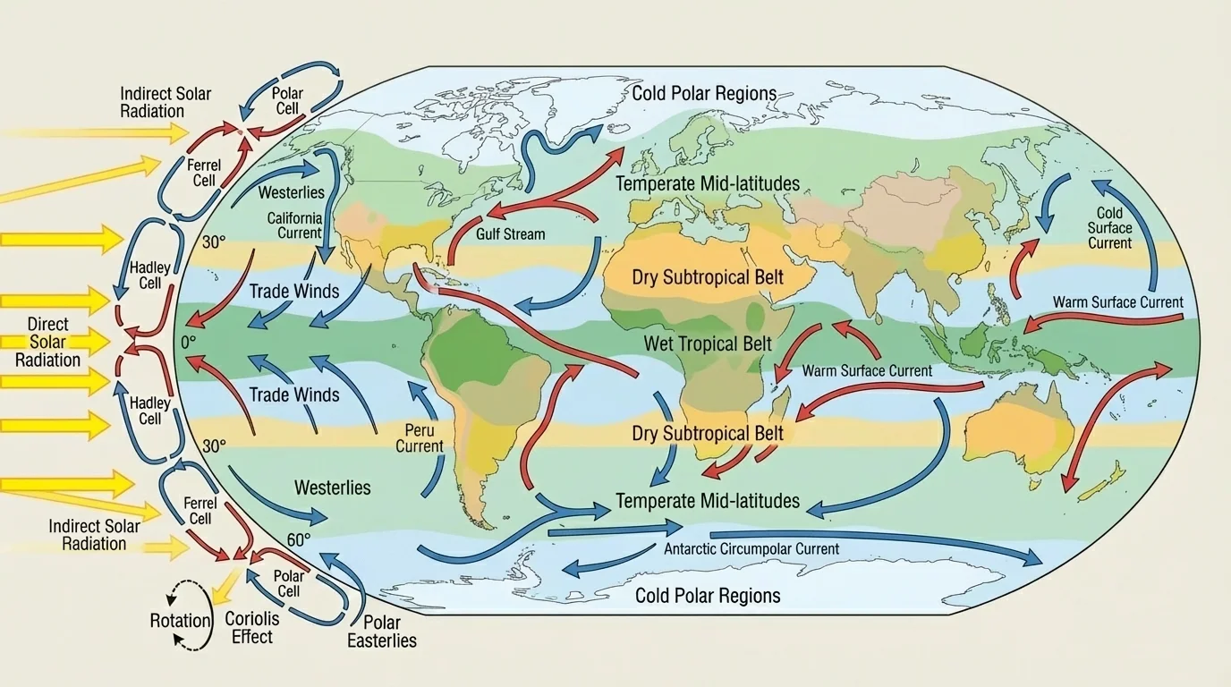
Once you understand the movement of air and ocean water, you can explain why broad climate zones repeat across Earth. A simplified global climate map, shown later in [Figure 4], displays a broad pattern: wet conditions are common near the equator, dry belts often occur around the subtropics, temperate zones occupy many middle latitudes, and the polar regions are colder.
Near the equator, strong heating causes rising air, frequent cloud formation, and lots of rainfall. That supports tropical rainforests in places such as the Amazon Basin, the Congo Basin, and parts of Southeast Asia. Around \(30^\circ\) north and south latitude, sinking air often leads to drier conditions. That is why major deserts such as the Sahara, Arabian, and Australian deserts are found in these broad belts.
Ocean currents can also make regional climates different from what latitude alone would predict. A warm current can make a coast milder and can contribute to wetter conditions. A cold current can cool the air above it and can sometimes help create foggy or dry coastal conditions. As a result, two places at similar latitudes can still have different climates if they are influenced by different ocean currents or by different positions relative to mountains and continents.
For example, western Europe is milder than some other places at similar latitudes because warm ocean water and moving air bring heat into the region. In contrast, some west coasts near cold currents are cooler and drier than expected. These are strong reminders that climate depends on circulation, not just location on a map.
Regional climate is the result of energy and water moving together
Heat transfer and water transfer happen at the same time. Warm regions can have strong evaporation. Moving air carries moisture. Cooling can lead to condensation and precipitation. Where air sinks and dries, rain is less common. Regional climate forms from these linked processes, not from a single cause.
The same circulation patterns that shape climate also influence storms, cloud cover, growing seasons, and water supply. Farmers, city planners, and engineers all depend on climate patterns when making decisions about crops, buildings, and water systems.
Climate patterns matter because water changes Earth's surface. In wetter climates, more rain and river flow can increase weathering and erosion. Weathering breaks rock into smaller pieces or changes it chemically. Erosion moves that material away by water, wind, ice, or gravity.
In humid tropical regions, heavy rainfall can wear down slopes, carry sediment into rivers, and reshape valleys. In dry regions, there may be less regular rain, but sudden storms can still cause flash floods that erode land quickly. Along coasts, waves driven by wind and ocean motion can slowly wear away cliffs and beaches.
Because climate influences how much water moves through a region, circulation patterns indirectly help shape landscapes. A rainy climate may support powerful rivers that carve channels and transport sediment. A cold climate may allow glaciers or seasonal freezing and thawing to break rock apart. A dry climate may have more wind erosion where soil is loose and vegetation is sparse.
Case study: from circulation to landscape change
Consider a tropical region near the equator.
Step 1: Unequal heating warms the region strongly.
Step 2: Warm, moist air rises and often produces heavy rainfall.
Step 3: Frequent rain increases runoff and river flow.
Step 4: Moving water erodes soil and rock and carries sediment downstream.
This shows how atmospheric circulation can eventually affect the shape of land.
Water movement also affects people. Regions with heavy rainfall may face floods and landslides. Regions with little rainfall may face drought. Understanding circulation helps communities prepare for these challenges.
You can observe a small version of uneven heating in everyday life. At the beach, land often heats faster than water during the day. Air over the warm land rises, and cooler air from over the water moves in. This creates a sea breeze. At night, the pattern can reverse because land cools faster. This local example helps students understand the larger global idea of heating differences causing circulation.
Another clue comes from comparing cities. A coastal city and an inland city at similar latitude may have different yearly temperature ranges because the nearby ocean moderates temperature. This is the same principle we saw earlier with heat storage in water and with circulation moving energy, as shown in [Figure 1] and connected to ocean transport in [Figure 3].
Some of the world's richest fishing areas exist where ocean circulation brings nutrients toward the surface. Tiny plankton grow well there, and entire food webs depend on that movement of water.
Desert locations also provide evidence. The repeating dry belts shown in [Figure 4] are not random. They match regions where sinking air is common in the broad circulation model. This is why very different continents can still have deserts in similar latitude zones.
Rainforests provide the opposite pattern. The same circulation model that explains dry subtropics explains the frequent rainfall near the equator. As we saw with rising air in [Figure 2], warm moist air tends to rise, cool, and produce precipitation.
All scientific models leave out some details. The model in this lesson explains big global patterns well, but real climates are also affected by mountain ranges, seasonal shifts, continental size, ice cover, vegetation, and changes in ocean conditions over time. Scientists improve models by comparing them with observations from satellites, weather stations, ocean buoys, and maps of temperature and rainfall.
Even with those limits, the model is extremely useful. It helps explain why climate zones repeat, why oceans matter so much, and why water movement influences both ecosystems and landscapes. When students can trace the chain from sunlight to heating to circulation to climate, they are thinking like Earth scientists.
| Cause | Immediate Effect | Larger Result |
|---|---|---|
| More direct sunlight near equator | Stronger heating | Warm air rises more often |
| Rising warm moist air | Cooling and condensation | More clouds and rain |
| Sinking air in subtropics | Air warms and dries | Drier climates are common |
| Wind over the ocean | Surface currents move | Heat is transported |
| Cold salty seawater | Higher density and sinking | Deep ocean circulation |
| Climate controls rainfall | Different water movement on land | Different weathering and erosion patterns |
Table 1. This table summarizes major cause-and-effect links between unequal heating, circulation, climate, and landscape change.
When you use this model, the most important question is not just "What is the climate here?" but "What processes caused it?" That shift from naming places to explaining systems is a major part of science.