The floor of the Atlantic Ocean is getting wider right now, even though you cannot see it happening. Deep under the sea, new rock is forming while, in other places, older ocean floor is sinking back into Earth. This may seem surprising at first: how can Earth's surface be created and destroyed at the same time?
Earth is not a fixed, unchanging world. Mountains rise, oceans open, continents crash together, and old seafloor disappears. These are not random events. They are part of a huge global system called plate tectonics. Understanding this system helps explain earthquakes, volcanoes, deep ocean trenches, and even why the same kinds of fossils are found on continents now separated by vast oceans.
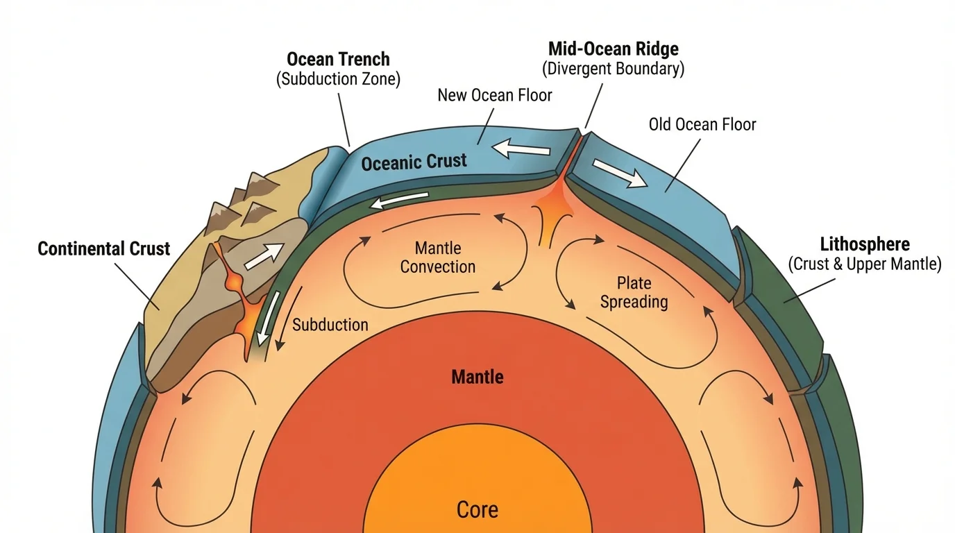
[Figure 1] The outer part of Earth is broken into large pieces called tectonic plates. These plates are made of the lithosphere, which includes the crust and the rigid uppermost mantle. The plates fit together somewhat like pieces of a cracked shell.
Below the lithosphere is a hotter, softer layer of the mantle called the asthenosphere. It is not a liquid ocean of rock, but over long periods it can slowly flow. Because of this, the rigid plates above it can move. Plate movement is extremely slow, often only a few centimeters each year, about as fast as fingernails grow.
Plate tectonics is the theory that Earth's outer shell is broken into moving plates that interact at their edges. Lithosphere means the rigid outer layer of Earth, and asthenosphere is the softer layer beneath it that allows the plates to move over time.
There are two main kinds of crust in these plates. Oceanic crust lies beneath oceans. It is usually thinner, denser, and made mostly of dark volcanic rock such as basalt. Continental crust makes up the continents. It is usually thicker, less dense, and often contains rocks such as granite. Because these crusts differ in thickness and density, they behave differently when plates collide.
Plate edges are especially important. Most major earthquakes, volcanoes, and mountain-building events happen at plate boundaries. Scientists group these boundaries into three major types: divergent, where plates move apart; convergent, where plates move together; and transform, where plates slide past one another.
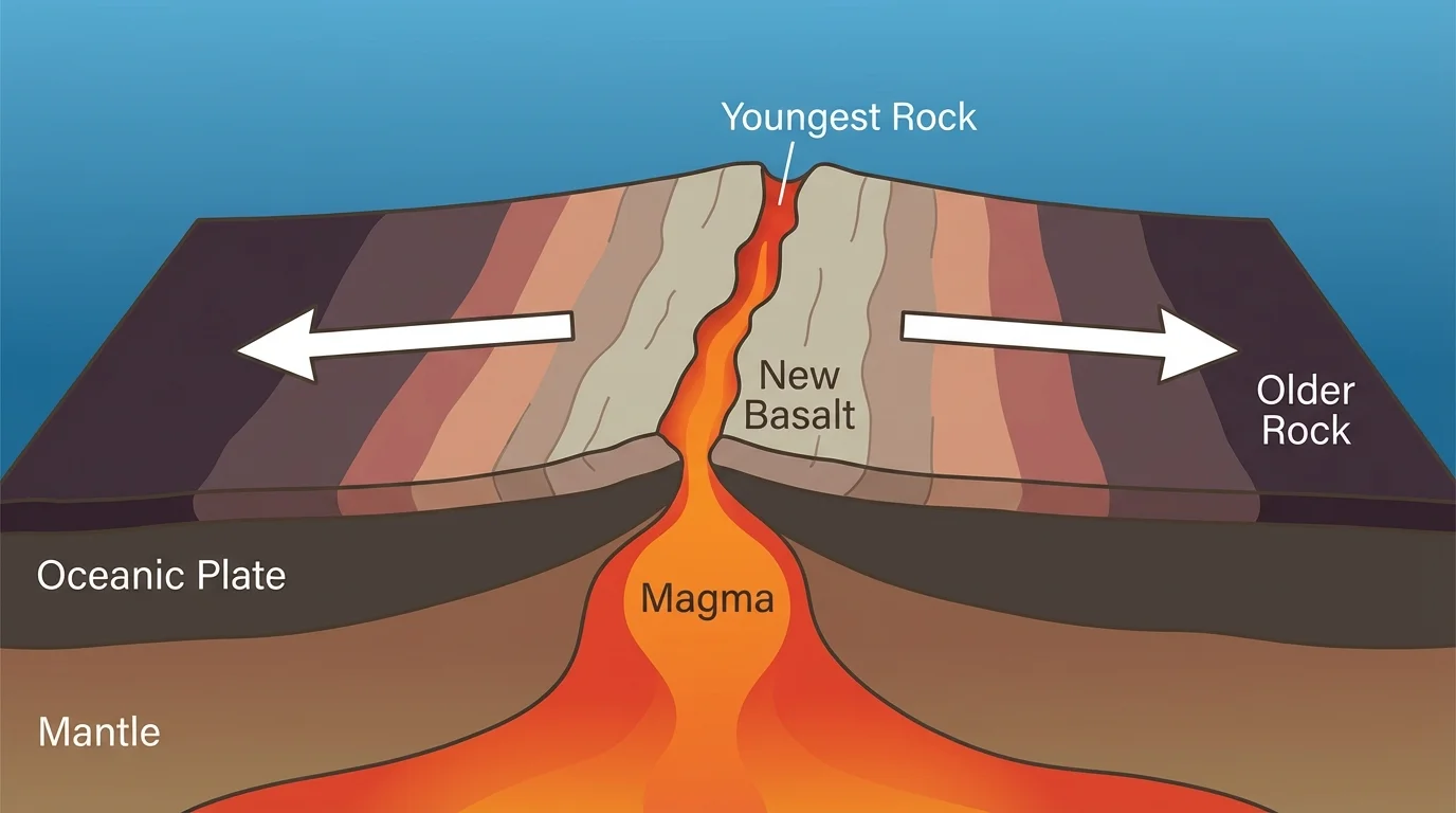
At a divergent boundary, two plates move away from each other. In the oceans, this usually happens along giant undersea mountain chains called mid-ocean ridges. These ridges run through the world's oceans like long seams on a baseball.
When plates separate at a ridge, hot material from deeper in the mantle rises. Some of it melts into magma. The magma pushes into cracks, reaches the seafloor, and cools. As it cools, it hardens into new oceanic crust. This process is called sea-floor spreading.
Because new crust forms again and again at the ridge, the youngest seafloor is found closest to the ridge. As more new rock forms, older rock is pushed farther away on both sides. Scientists have measured this pattern in many oceans. It is one of the strongest pieces of evidence that seafloor spreading is real.
How ridges act like giant cracks in the ocean floor
A mid-ocean ridge is not just a mountain chain. It is the place where Earth's crust is splitting apart and being rebuilt. Magma rises because pressure decreases as material moves upward. When the magma cools, it forms fresh basalt, adding new rock to the seafloor little by little over millions of years.
[Figure 2] The Mid-Atlantic Ridge is a famous example. It runs down the center of the Atlantic Ocean. North America and Europe are slowly moving apart in the North Atlantic, while South America and Africa are slowly moving apart in the South Atlantic. The ridge marks where new Atlantic seafloor is forming today.
Scientists can estimate spreading rates. For example, if two plates separate at about 2 centimeters per year each from a ridge, the total widening of the ocean may be about 4 centimeters per year. In 1 million years, that would be about 40 kilometers because 4 centimeters per year is 0.04 meters per year, and \(0.04 \times 1{,}000{,}000 = 40{,}000\) meters, which is 40 kilometers. This is slow on a human timescale but huge over geologic time.
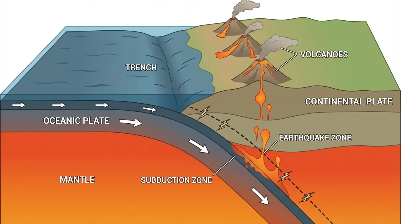
Ocean floor does not keep getting created forever without limit. Old seafloor is destroyed at a convergent boundary, where plates move toward each other. When a dense oceanic plate meets another plate, it can bend and sink into the mantle at a deep valley called a trench.
[Figure 3] This sinking process is called subduction. During subduction, old oceanic crust is carried downward into Earth. As it goes deeper, heat and pressure increase. Some rock melts, and magma may rise to the surface and feed volcanoes. This is why many volcanoes form near subduction zones.
Subduction zones are also places where many strong earthquakes occur. As one plate scrapes past another, stress builds up. When the rocks finally slip, the ground shakes. Some of the largest earthquakes on Earth happen in these regions, especially around the Pacific Ocean.
Real-world example: The Andes Mountains
Along the west coast of South America, the Nazca Plate is moving beneath the South American Plate.
Step 1: The oceanic Nazca Plate reaches the trench off the coast.
Step 2: Because it is denser, it sinks beneath the continent.
Step 3: The sinking plate helps generate magma, which rises and forms volcanoes.
Step 4: Compression and uplift help build the Andes Mountains.
This one plate boundary produces a trench, earthquakes, volcanoes, and a major mountain range.
Oceanic crust is usually much younger than continental crust because it is constantly recycled. Some continental rocks are billions of years old, but most ocean floor is much younger because it forms at ridges and is destroyed at trenches.
Not all plate boundaries create or destroy crust. At a transform boundary, plates slide horizontally past one another. Crust is not made or destroyed there, but earthquakes are common because the plates can get stuck and then suddenly slip.
A well-known example is the San Andreas Fault in California. It marks part of the boundary between the Pacific Plate and the North American Plate. People living near this boundary may feel earthquakes because plate motion releases stored energy in the rocks.
These three boundary types work together as a giant system. Divergent boundaries create ocean crust, convergent boundaries recycle it, and transform boundaries help plates adjust as they move across Earth's curved surface. The pattern fits together like parts of a global machine.
| Boundary type | Plate motion | Main result | Common features |
|---|---|---|---|
| Divergent | Move apart | New crust forms | Mid-ocean ridges, rift valleys, volcanism |
| Convergent | Move together | Old crust may be destroyed or land may be uplifted | Trenches, volcanoes, mountains, earthquakes |
| Transform | Slide past | Crust is neither created nor destroyed | Faults, earthquakes |
Table 1. Comparison of the three main types of plate boundaries and their effects on Earth's surface.
Scientists think plate motion is caused by several related forces. Heat from inside Earth drives slow movement in the mantle. This movement is often called mantle convection. Hot material rises, cool material sinks, and this circulation helps move the plates above.
Another force is ridge push. At a mid-ocean ridge, newly formed crust is high and warm. As it cools, it becomes denser and slides away from the ridge, helping push the plate outward. A third force is slab pull. When an old, cold oceanic plate sinks into a trench, its weight can pull the rest of the plate behind it.
The Pacific Plate moves so steadily that Hawaii's volcanic island chain records its path. As the plate shifts over a hot spot, new islands form while older ones move away and stop growing.
Even though plates move slowly, the distances add up. If a plate moves at 5 centimeters per year, in 10 million years it moves 500 kilometers, because 5 centimeters per year is 0.05 meters per year and \(0.05 \times 10{,}000{,}000 = 500{,}000\) meters, which is 500 kilometers. That is far enough to reshape oceans and continents.
The slow speed can make tectonics feel unimportant, but this process has built mountain systems, opened entire oceans, and rearranged the map of the world. Over millions of years, small yearly motions become dramatic change.
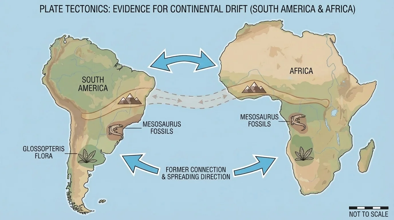
The idea of moving plates is accepted because many different kinds of evidence point to the same conclusion. Matching fossils, rock layers, mountain belts, and ocean-floor patterns all support plate motion, as [Figure 4] demonstrates with continents now separated by oceans.
One major clue comes from fossils. The same fossil species have been found on continents that are now far apart. For example, fossils of the reptile Mesosaurus have been found in both South America and Africa. This animal lived in freshwater, so it probably did not swim across a wide ocean. The simpler explanation is that these continents were once joined.
Rocks also provide evidence. Some mountain belts and rock layers on one continent match the age and type of rocks on another continent across the ocean. When the continents are placed together, the rock patterns line up. This suggests they formed as part of the same ancient landmass.
Rocks and fossils act like records of Earth's past. A fossil tells scientists what kinds of living things existed in an area, while the rock around it gives clues about the environment where it formed.
Another important clue comes from the shape of the continents. South America and Africa seem to fit together, especially along the edges of their continental shelves, not just the present coastlines. This fit is not perfect like hand-cut puzzle pieces, but it is striking.
The ocean floor gives even stronger evidence. When lava cools at ridges, tiny iron-bearing minerals line up with Earth's magnetic field. Earth's magnetic field has reversed many times in the past, so stripes of rock on the seafloor record alternating magnetic directions. These stripes are symmetrical on both sides of a ridge, showing that new crust formed at the center and moved outward.
Scientists also drill into the seafloor and measure rock ages. The rocks closest to ridges are the youngest, and the rocks farther away are older. This matches exactly what sea-floor spreading predicts. The pattern seen at ridges in [Figure 2] is confirmed by these age measurements.
Maps of ancient Earth reveal that continents and oceans have changed greatly over time. Scientists use fossils, rock types, mountain belts, and clues about past climates to reconstruct these ancient patterns, as [Figure 5] shows through a supercontinent reconstruction.
About 300 million years ago, most of Earth's land was joined in a supercontinent called Pangaea. Surrounding it was a vast global ocean. Over time, Pangaea broke apart. The continents moved away from one another, opening new oceans such as the Atlantic.
Evidence for ancient climates also supports these reconstructions. For example, glacial scratches and deposits are found today in parts of Africa, India, South America, and Australia. These regions are now in very different climates, but when the continents are placed together in their earlier positions, the glacial evidence makes much more sense.
How scientists rebuild ancient worlds
Scientists do not guess where continents used to be. They compare many kinds of evidence: fossil locations, rock ages, mountain chains, magnetic records, and signs of past environments. When several lines of evidence agree, scientists can create maps of ancient land and water patterns with much greater confidence.
Continents have collided many times in Earth's history. These collisions can crumple crust and build mountains. The Himalayas, for example, are still rising because the Indian Plate continues to push into the Eurasian Plate. In this kind of collision, thick continental crust is squeezed upward rather than easily subducted.
Continents have also spread apart. East Africa is an example of a continent beginning to split. In the East African Rift, the crust is stretching. If this process continues for millions of years, a new ocean basin may eventually form, much like the early stages of the Atlantic Ocean long ago.
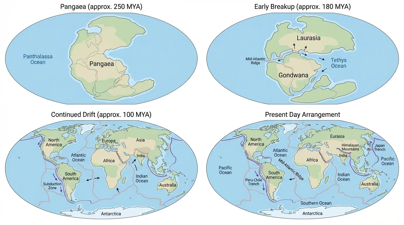
Plate tectonics is not only about the distant past. It affects people today. Cities near plate boundaries may face earthquakes, volcanic eruptions, or tsunamis. Understanding plate boundaries helps scientists identify where these hazards are most likely.
For example, subduction zones around the Pacific create many dangerous earthquakes and volcanoes. This broad region is often called the Ring of Fire. Because old ocean floor is recycled there, the Pacific basin is surrounded by tectonic activity. The subduction pattern from [Figure 3] helps explain why this ring exists.
Plate tectonics also shapes resources people use. Many metal ores are connected to volcanic or mountain-building processes. Geothermal energy often occurs in regions where heat from below is closer to the surface. Even the landscapes people build on, farm on, or travel across have been influenced by tectonic processes over long periods.
Real-world example: Why earthquake maps matter
Suppose a coastal country lies near a trench where one plate is subducting beneath another.
Step 1: Scientists map past earthquakes and the nearby plate boundary.
Step 2: They monitor ground motion with instruments that detect tiny plate movements.
Step 3: They use this information to improve building codes and warning systems.
Step 4: Communities prepare evacuation plans for earthquakes or tsunamis.
Knowledge of plate motion cannot stop hazards, but it can help reduce risk and save lives.
You can model part of plate tectonics with two strips of paper and a center opening in a box lid. Pull both paper strips outward from the center to represent seafloor spreading. The center acts like a ridge where new crust appears. Then push one strip beneath another to model subduction at a trench.
This model is not perfect, because Earth's interior is much more complex. Still, it helps show a key idea: Earth's surface is part of a connected system in which crust is created, moved, and recycled. The global pattern links ridges, trenches, earthquakes, volcanoes, and changing maps through one unifying explanation.
When scientists compare the age of ocean crust, the magnetic stripes on the seafloor, the fit of continents, and the matching fossils across oceans, all the evidence points in the same direction. Earth's plates have moved great distances, collided, and spread apart. The planet beneath our feet is active, dynamic, and still changing.