Earth can feel solid and permanent, yet the ground beneath cities, forests, and oceans is part of a planet that is constantly changing. Mountains rise and wear down. Seafloor forms and sinks back into the mantle. Coastlines shift after storms, while whole continents drift over millions of years. An important point is that these changes do not all happen at the same speed or over the same size area. Some are sudden and local, like an earthquake rupture. Others are slow and enormous, like the opening of an ocean basin.
To understand Earth's features, scientists separate processes into two broad groups. Internal processes come from energy inside the planet. They include plate motion, earthquakes, mountain building, and volcanism. Surface processes act at or near Earth's surface and include weathering, erosion, deposition, glacial movement, and mass wasting such as landslides.
These groups are connected. Internal processes create new topography by lifting crust, forming volcanoes, or opening ocean basins. Surface processes then reshape that topography by breaking rock down and moving sediment. A mountain range, for example, exists because tectonic forces push crust upward, but its slopes, valleys, and sediments are shaped by water, ice, wind, and gravity.
Internal processes are Earth changes driven by heat and motion inside the planet. Surface processes are changes driven mainly by water, wind, ice, organisms, and gravity at Earth's surface. Spatial scale means the size of the area affected, from tiny mineral grains to entire ocean basins. Temporal scale means the length of time over which change occurs, from seconds to millions of years.
A major goal in Earth science is to build a model that links these processes across scales. A good model does not need every detail of every place on Earth. Instead, it identifies patterns: what energy source drives change, what materials are involved, how quickly change happens, and what kinds of features are produced.
Earth's changing surface is powered by a few major energy sources. The first is internal heat, which comes from leftover energy from Earth's formation and from radioactive decay inside the planet. This heat drives motion in the mantle and ultimately causes plates to move. The second is solar energy, which powers the atmosphere and water cycle. Wind, rain, rivers, and many weather patterns depend on incoming sunlight. The third is gravity, which pulls materials downhill, helps dense plates sink into the mantle, and moves water and sediment from high places to lower ones.
These energy sources often work together. Rainfall produced by the climate system erodes a tectonically uplifted mountain range. Gravity moves rock fragments down steep slopes. Rivers carry the fragments toward the sea, where they may become part of new sedimentary layers. In this way, the shape of Earth's surface records interactions among the interior, the atmosphere, the hydrosphere, and the biosphere.
Even the ocean floor is geologically young compared with many continental rocks. Most oceanic crust is less than about 200 million years old because it is continually created at ridges and recycled into the mantle at subduction zones.
When scientists describe change quantitatively, they often use rates. A simple relationship is \(\textrm{rate} = \dfrac{\textrm{change}}{\textrm{time}}\). If a coastline retreats by \(20 \textrm{ m}\) in \(10 \textrm{ years}\), the average retreat rate is \(\dfrac{20}{10} = 2 \textrm{ m/year}\). This does not mean the coast moved exactly the same amount each year, but it helps compare processes that happen over different times.
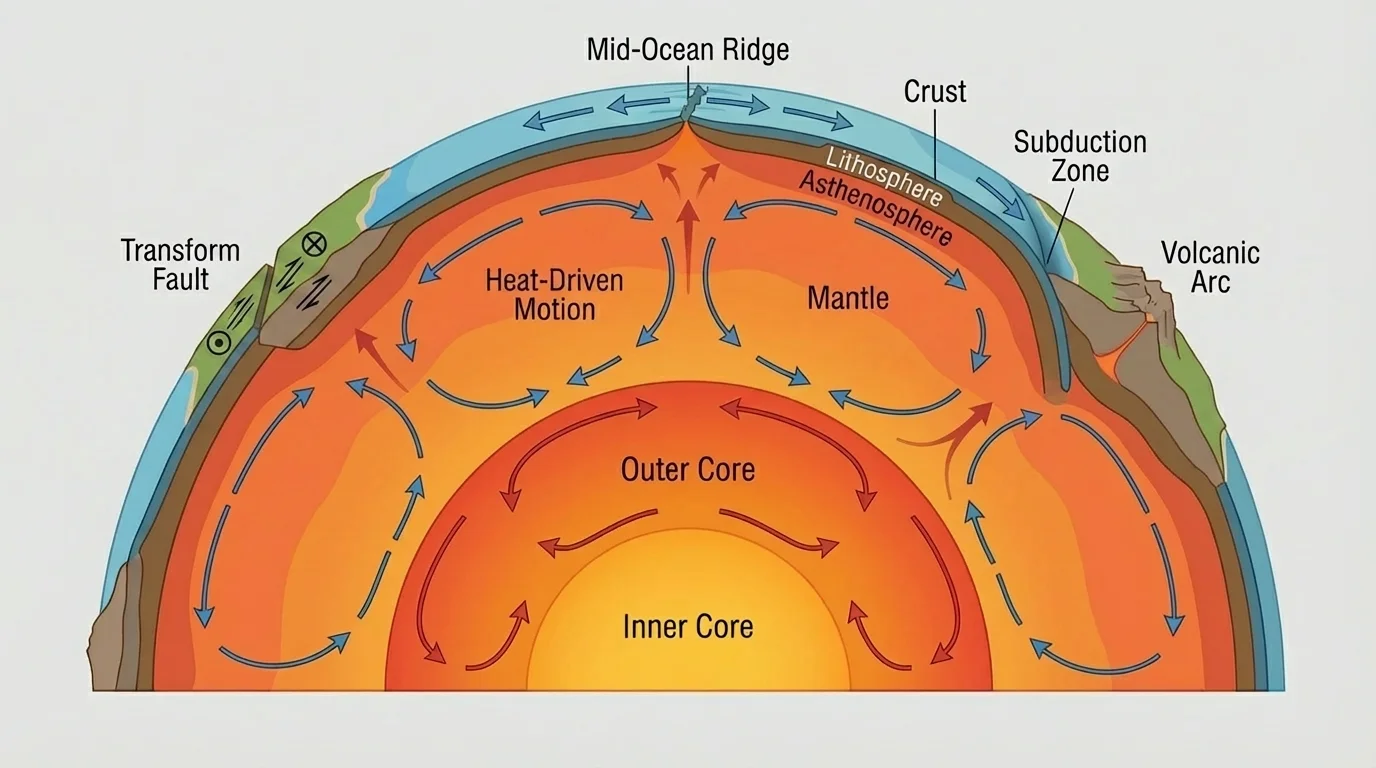
Earth's outer shell is not one unbroken piece. The lithosphere, shown in [Figure 1], includes the crust and the rigid uppermost mantle. It is broken into tectonic plates that move slowly over a weaker layer called the asthenosphere. This motion is central to any model of how large-scale continental and ocean-floor features form.
Below the lithosphere lies most of the mantle, which is hot enough to flow very slowly over long periods. The outer core is liquid and rich in iron and nickel, while the inner core is solid because pressure is extremely high. The movement of heat through Earth's interior helps drive plate motion, although the exact motion of plates involves several forces, including ridge push and slab pull.
The motion of plates is slow on a human timescale but powerful on a geologic timescale. A plate might move a few centimeters per year, roughly as fast as fingernails grow. Over \(1{,}000{,}000 \textrm{ years}\), however, a plate moving at \(5 \textrm{ cm/year}\) would travel \(5{,}000{,}000 \textrm{ cm} = 50{,}000 \textrm{ m} = 50 \textrm{ km}\). Over tens of millions of years, that distance becomes enough to rearrange oceans and continents.
This is a good example of why temporal scale matters. A process may seem insignificant from one year to the next, yet become landscape-changing over deep time. As we see again in [Figure 1], a very thin rigid shell riding over a slowly moving interior can still produce major crustal change.
Why slow motion can create huge features
Plate tectonics shows that a tiny yearly change can accumulate into a massive result. Repeated movement along plate boundaries creates mountain belts, ocean basins, trenches, and volcanic arcs. Earth science often depends on adding small yearly changes over very long intervals.
The continents and seafloor are different mainly because of crust type. Continental crust is generally thicker and less dense, so it resists sinking. Oceanic crust is thinner and denser, so it forms low-lying ocean basins and can sink back into the mantle at subduction zones.
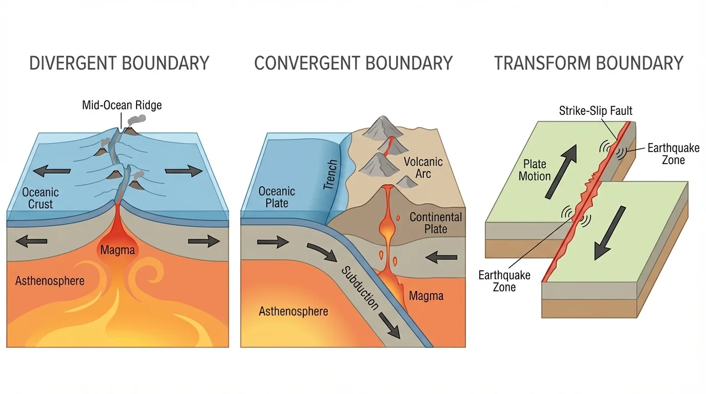
Most large crustal features form where plates interact, and [Figure 2] illustrates the three main boundary types. At divergent boundaries, plates move apart. Magma rises, cools, and creates new oceanic crust. This process forms mid-ocean ridges, which are long underwater mountain chains that extend through the world's oceans.
At convergent boundaries, plates move toward each other. If oceanic crust meets continental crust, the denser oceanic plate usually sinks in a process called subduction. This can form deep ocean trenches and volcanic mountain chains on land. If two continental plates collide, neither plate sinks easily, so the crust crumples and thickens, building high mountain ranges. At transform boundaries, plates slide past each other, producing faults and earthquakes rather than creating or destroying much crust.
Volcanoes and earthquakes often cluster along these boundaries because plate interaction concentrates stress and magma movement. A volcanic island arc in the ocean and a mountain belt on a continent may look very different at the surface, but both can result from the same plate-tectonic system. That is why a model based on boundary type is more useful than memorizing many separate landforms.
Ocean-floor features are especially tied to plate tectonics. New seafloor forms at ridges, spreads outward, cools, and becomes denser. Farther away, it may descend at trenches. Continental features are also strongly linked to tectonics, but once uplifted, they are heavily modified by surface processes. In that sense, internal processes often create the stage, while surface processes rewrite the details.
The boundary patterns in [Figure 2] also explain why some features occur in long belts instead of isolated spots. Mid-ocean ridges trace divergent boundaries, trenches trace subduction zones, and many earthquake zones trace transforms. The geometry of plate motion controls the geometry of many Earth features.
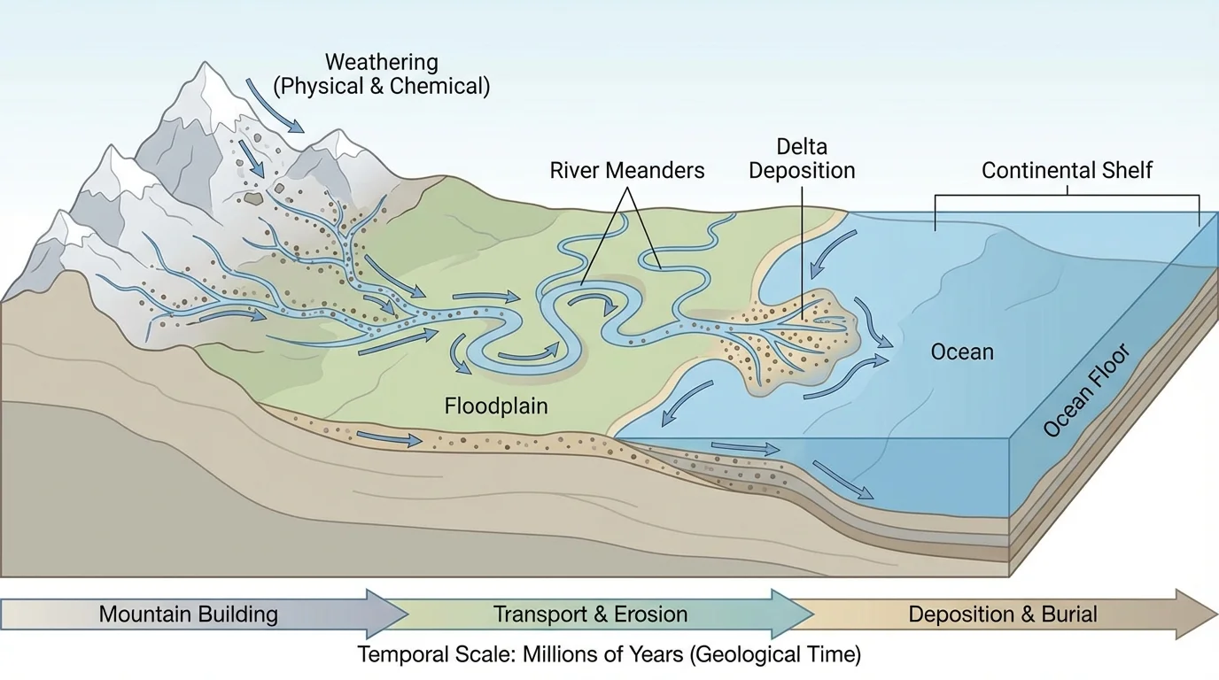
[Figure 3] Once crust is exposed at the surface, external forces begin to modify it. Weathering breaks rock into smaller pieces or changes its minerals chemically. Physical weathering includes freeze-thaw cracking and root growth. Chemical weathering includes reactions involving water, oxygen, and dissolved acids. For example, some minerals react with water and \(\textrm{CO}_2\) to form new minerals and dissolved ions.
Weathered material is removed by erosion and then dropped elsewhere by deposition. Flowing water is one of the most powerful agents. Streams cut channels, rivers deepen valleys, and sediments settle where water slows. Over time, this creates floodplains, deltas, alluvial fans, and layered sediment deposits.
Ice is another powerful surface agent. Glaciers can carve broad valleys, transport large rock fragments, and leave deposits as they melt. Wind is especially important in dry environments, where it can move sand and fine dust. Gravity causes landslides, rockfalls, and soil creep, especially where slopes are steep or water-saturated.
Surface processes usually act on smaller scales than plate tectonics, but not always. A single landslide may affect a hillside within minutes, while a river system can drain an area of thousands of square kilometers over millions of years. Likewise, a glacier can reshape an entire region. This is why scale should never be reduced to "small" versus "large." The same type of process can operate across a wide range of sizes.
Real-world application: estimating uplift versus erosion
Suppose a mountain region is rising because of tectonic forces at an average rate of \(4 \textrm{ mm/year}\), while erosion lowers the surface at \(2.5 \textrm{ mm/year}\).
Step 1: Find the net rate of elevation change.
The net rate is uplift minus erosion: \(4 - 2.5 = 1.5 \textrm{ mm/year}\).
Step 2: Apply the rate over time.
Over \(10{,}000 \textrm{ years}\), the elevation change is \(1.5 \textrm{ mm/year} \times 10{,}000 \textrm{ years} = 15{,}000 \textrm{ mm}\).
Step 3: Convert units.
Because \(1{,}000 \textrm{ mm} = 1 \textrm{ m}\), the change is \(15 \textrm{ m}\).
Even though both rates seem tiny each year, the landscape rises by 15 meters over that interval.
Notice what this example means for modeling: to explain the shape of a landscape, you often must compare competing processes. Uplift may create relief, while erosion reduces it. The visible result is the balance between them, not one process acting alone.
Spatial scale asks, "How large is the system or feature we are studying?" At the smallest scales, weathering changes individual mineral grains and tiny fractures in rock. At an intermediate scale, streams carve valleys, glaciers reshape mountain ranges, and volcanoes build cones. At the largest scales, plate motions create ocean basins, continental margins, and long mountain belts.
Scientists often organize Earth features by size because different processes dominate at different scales. A pebble in a stream may be shaped mostly by abrasion over days or months. A canyon may reflect river erosion over millions of years. An ocean basin reflects seafloor spreading and subduction over tens to hundreds of millions of years.
| Scale | Typical size | Examples of processes | Examples of resulting features |
|---|---|---|---|
| Small | Millimeters to meters | Mineral weathering, soil formation, frost cracking | Rock fragments, soil horizons, fractures |
| Medium | Meters to kilometers | River erosion, landslides, volcanic eruptions, glacier movement | Valleys, deltas, dunes, lava flows |
| Large | Hundreds to thousands of kilometers | Plate collision, seafloor spreading, subduction | Mountain belts, trenches, ridges, continents and ocean basins |
Table 1. Examples of Earth processes and features organized by spatial scale.
These scales overlap. A volcanic eruption may build a local cone in days, but repeated eruptions over a hotspot can help create a much larger island chain over millions of years. The same process can therefore contribute to different features depending on duration and setting.
Earth processes operate on dramatically different time scales, and [Figure 4] places them side by side. Some changes are sudden. Earthquakes release stored stress in seconds to minutes. Volcanic eruptions can transform nearby landscapes in hours to days. A major storm can move enough sediment in one event to redraw a beach.
Other changes are intermediate in pace. Rivers may take thousands to millions of years to carve deep valleys. Glaciers advance and retreat over climate cycles. Soil can take centuries to develop. Coral reefs and barrier islands also change through repeated growth, storm damage, and sediment transport over long but still observable periods.
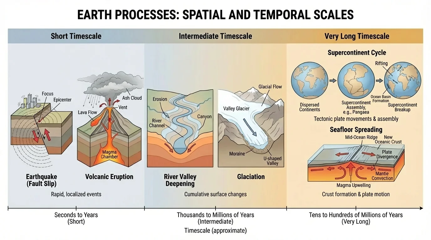
At the longest time scales, tectonic cycles dominate. Continents assemble into supercontinents and later break apart. Ocean basins open and close. Entire mountain belts are raised, eroded, and recycled. Features that seem permanent on a human timescale may be temporary on a geologic timescale.
A useful way to think about this is accumulation. If a fault slips \(3 \textrm{ m}\) in one earthquake every \(1{,}000 \textrm{ years}\), the long-term average slip rate is \(\dfrac{3 \textrm{ m}}{1{,}000 \textrm{ years}} = 0.003 \textrm{ m/year} = 3 \textrm{ mm/year}\). A sudden event can therefore contribute to a long-term pattern. The timeline in [Figure 4] makes clear that Earth's history is built from both rare bursts and slow continuous processes.
Rates and total change are connected. A very slow process can still produce major results if it continues for enough time, while a rapid process may produce only local change if it is brief.
This is why geologists use both present observations and evidence preserved in rock layers, landforms, and seafloor patterns. The present helps explain the past, but only if the timescale is taken seriously.
Earth's systems do not simply change in one direction. They often involve feedback, meaning that a change triggers effects that either increase the original change or reduce it. A positive feedback amplifies change. A negative feedback reduces or stabilizes it.
For example, fresh volcanic ash in the atmosphere can reflect sunlight and temporarily cool climate. That cooling is an Earth-system response to an eruption. In colder conditions, snow and ice can reflect more sunlight, which may increase cooling further. This is a positive feedback because the initial cooling leads to conditions that strengthen cooling.
On the other hand, erosion often acts as a negative feedback on mountain building. As tectonic uplift raises mountains, steeper slopes and greater relief increase erosion. That erosion removes material, partly opposing the uplift. The mountain range may still rise, but not as quickly as tectonics alone would produce.
Feedbacks connect systems across scales
A tectonic event can alter topography, which changes river patterns, which changes erosion, which changes sediment supply to coasts and oceans. Likewise, climate affects ice and water flow, which reshape land, which can in turn influence local climate. Earth systems are dynamic because one change often triggers another.
Feedbacks are important in model building because they explain why Earth does not respond in a simple straight line. The same initial event may lead to different outcomes depending on whether stabilizing or amplifying feedbacks dominate.
A useful scientific model for this topic includes five parts: energy source, process, scale, feature formed, and feedbacks. For example, internal heat drives plate motion; plate motion at a convergent boundary causes uplift and volcanism; these processes act across hundreds of kilometers over millions of years; the resulting features include mountain belts, volcanoes, and trenches; erosion then modifies the uplifted land and may reduce relief.
Another example starts with solar energy and gravity. Solar energy powers rainfall, and gravity moves water downhill. Rivers erode rock and transport sediment at scales from local channels to continental drainage basins. Over time, valleys deepen and sediments are deposited in floodplains, deltas, and offshore basins. If tectonic uplift increases slope, river erosion may speed up, creating a feedback between internal and surface processes.
Model example: one landscape, many interacting processes
Consider a coastal mountain region near an active plate boundary.
Step 1: Internal driver
Converging plates uplift the crust and may generate volcanoes and earthquakes.
Step 2: Surface response
Rain, streams, landslides, and glaciers weather and erode the uplifted rock.
Step 3: Sediment transfer
Rivers carry sediment from mountains to plains, estuaries, and the ocean.
Step 4: Feature formation
The region develops steep peaks, deep valleys, floodplains, and coastal sediment deposits.
Step 5: Feedbacks and scales
Steeper slopes increase erosion, while sediment deposited offshore may later be uplifted again by tectonics. Local storms can trigger immediate landslides, while plate motion shapes the whole region over millions of years.
This kind of model explains a wide range of features without requiring memorization of every named landform.
The strength of a model is that it can be applied to unfamiliar places. If you know the boundary type, climate, slope, and major transport agents, you can predict the kinds of features likely to form and how they might change over time.
Understanding these processes matters far beyond the classroom. Hazard planning depends on knowing where earthquakes, volcanic eruptions, tsunamis, landslides, and coastal erosion are more likely. Engineers need to understand soil stability, sediment movement, and fault zones before designing roads, bridges, dams, and buildings.
Resource exploration also relies on Earth-process models. Many mineral deposits are linked to tectonic and hydrothermal systems. Groundwater movement depends on rock layers and fractures created or modified by geologic processes. Offshore energy resources and marine sediments are tied to basin formation and sediment deposition.
Climate studies also connect to Earth surface change. Glacial deposits preserve evidence of past climate. Sediment layers record floods, droughts, and sea-level changes. Volcanic eruptions can briefly affect global climate by placing ash and gases into the atmosphere. Understanding the interaction between climate and tectonics helps scientists reconstruct Earth's history.
"The present is the key to the past."
— A guiding principle in geology
That principle does not mean the present looks exactly like the past. It means the same kinds of processes—uplift, erosion, volcanism, deposition, faulting, and climate-driven change—help explain ancient rocks and landforms when we consider the correct scales of time and space.