A city can rise because of a river, become wealthy because of coal or oil, and then be forced to rebuild because of an earthquake, flood, or drought. Human history is not shaped by people alone. It is also shaped by Earth itself. The land provides water, soil, metals, forests, and fuels, but it also produces hazards such as volcanoes, hurricanes, and earthquakes. Over longer periods, shifts in climate can change growing seasons, sea level, and the availability of fresh water. To understand why people live where they do and why societies change over time, we have to look at evidence from both human decisions and Earth systems.
Human activity depends on the environment. Settlements need water, food, energy, and materials for buildings and tools. Because of this, places with abundant resources often become population centers. At the same time, people often remain in risky places because those same locations offer major benefits. Coastal zones support fishing, trade, and transportation, but they also face hurricanes and tsunamis. Volcanic regions can be dangerous, yet volcanic soils are often extremely fertile.
Earth scientists and historians construct explanations by connecting evidence to patterns. Evidence can include maps of settlements, records of harvests, satellite images, ice cores, tree rings, written accounts, archaeological remains, and measurements of temperature or rainfall. A strong explanation does not just list facts. It makes a claim, supports that claim with evidence, and shows why the evidence leads to the conclusion.
A natural resource is any material or feature from Earth that people use, such as water, fertile soil, timber, minerals, and fossil fuels.
A natural hazard is a natural event or process that can harm people, property, or ecosystems, such as an earthquake, flood, drought, wildfire, or volcanic eruption.
Climate is the long-term pattern of temperature, precipitation, winds, and other atmospheric conditions in a region.
These ideas matter today just as much as they mattered in the past. Modern cities still depend on reservoirs, farmland, energy sources, and transportation routes. At the same time, climate change is increasing heat waves, altering rainfall, and raising sea level in many regions, which affects where and how people can live.
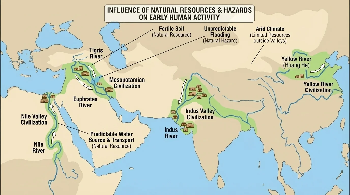
The first major factor is resource availability. [Figure 1] Access to fertile soil and fresh water strongly influences where settlements form, and this pattern appears repeatedly in world history. When a region can support agriculture, it can also support larger populations, more specialized jobs, and eventually cities.
Early civilizations developed near rivers such as the Nile, Tigris-Euphrates, Indus, and Yellow River. Rivers provided drinking water, fish, transportation, and seasonal floods that deposited nutrient-rich sediment. That sediment improved crop production without modern fertilizers. In many areas, reliable harvests allowed societies to store food, support governments, and develop writing, trade, and engineering.
Other resources shape human activity in different ways. Forests provide timber for fuel, tools, ships, and construction. Mineral resources such as iron, copper, and gold support technology, trade, and political power. Fossil fuels such as coal, oil, and natural gas transformed the modern world by powering factories, transportation, and electricity generation. Regions rich in these resources often experienced rapid economic growth, but they could also experience environmental damage, conflict, or dependence on a single industry.
The Industrial Revolution is a powerful example. In Britain, large coal deposits helped fuel steam engines and factories. This changed where people worked and lived. Populations moved toward industrial cities, transportation networks expanded, and production increased dramatically. Resource availability did not just affect economics. It helped reshape social life, labor systems, and political power.
Case study: Water and cities in the American Southwest
Step 1: Identify the resource challenge.
Large cities such as Phoenix and Las Vegas are located in dry regions with limited natural rainfall.
Step 2: Examine the evidence.
These cities depend on rivers, reservoirs, canals, groundwater, and long-distance water management systems.
Step 3: Explain the effect on human activity.
Because water is limited, governments regulate use, engineers design storage and delivery systems, and growth is tied to water availability.
This shows that a resource does not have to be abundant locally if technology and infrastructure make it accessible, but scarcity still shapes decisions.
Natural resources also influence migration. People may move toward places with jobs in mining, farming, fishing, or energy production. Later, if resources run low or become less profitable, populations may decline. This pattern appears in boomtowns built around gold, silver, or oil discoveries.
Scientists and historians do not guess about these connections. They use multiple forms of evidence. Settlement maps show that many major cities began near rivers, coasts, or valuable resources. Soil studies reveal why some valleys were especially productive. Archaeological evidence can show irrigation canals, storage areas, metal tools, and trade goods. Written records describe taxes on grain, control of mines, or conflicts over land and water.
Modern evidence includes satellite data, economic records, and land-use maps. For example, satellite images can show irrigated farmland in dry areas, while energy maps show how pipelines, ports, and refineries cluster near resources. When these patterns are compared with population density and transportation networks, it becomes clear that resource distribution affects human choices at both local and global scales.
| Resource | How it influences human activity | Example |
|---|---|---|
| Fresh water | Supports drinking, farming, sanitation, and industry | River valley settlements and modern reservoir systems |
| Fertile soil | Increases crop yields and supports dense populations | Nile floodplain agriculture |
| Minerals | Provide raw materials for tools, machines, and trade | Iron and copper mining regions |
| Fossil fuels | Supply energy for industry and transportation | Coal fields during industrialization |
| Forests | Provide timber, fuel, and habitat resources | Shipbuilding and construction regions |
Table 1. Examples of major natural resources and the ways they shape settlement, economy, and technology.
Notice that the same resource can bring both opportunity and risk. Oil can create jobs and national wealth, but spills and air pollution can harm ecosystems and health. Rich farmland can support cities, but overuse may lead to soil erosion. Understanding human activity means looking at both benefits and consequences.
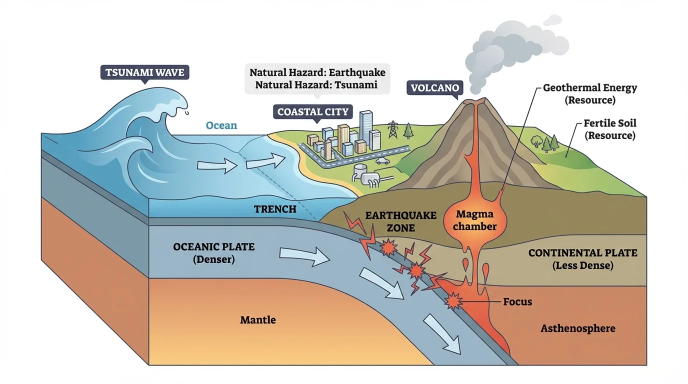
[Figure 2] A natural hazard can suddenly disrupt human activity through injury, death, property loss, and environmental damage. Many of the most dangerous hazard zones are located where tectonic or coastal processes are active. Hazards do not affect all places equally. Their impact depends on population density, preparedness, building design, warning systems, and the ability of communities to respond.
tectonic plates move slowly, but their interactions can produce earthquakes, volcanic eruptions, and tsunamis. Floods may occur when heavy rainfall overwhelms rivers or drainage systems. Drought develops over longer periods when precipitation remains below normal. Wildfires often become more severe when heat, dryness, and wind combine. Hurricanes draw energy from warm ocean water and can bring storm surge, flooding, and destructive winds.
People often continue living in hazardous places because those locations offer major advantages. Coastal cities are important for trade and transportation. Volcanic slopes may support productive agriculture. Fault zones may cut through regions that already contain major cities. The result is a constant trade-off between benefit and risk.
Hazards influence human activity in at least four major ways. First, they can cause immediate destruction of homes, roads, bridges, crops, and water systems. Second, they can trigger migration, either temporary or permanent. Third, they can change government policy, such as building codes, land-use rules, and emergency planning. Fourth, they can reshape economies by damaging tourism, farming, fisheries, or industry.
Volcanic ash can damage airplane engines even when an eruption occurs far from a city. That means a geologic event in one place can interrupt travel and trade across entire regions.
The effects of hazards also reveal inequality. Wealthier communities may have stronger infrastructure and insurance, while poorer communities often face greater losses and slower recovery. So when scientists explain the impacts of a hazard, they consider not only the physical event but also the vulnerability of the people affected.
The eruption of Mount Vesuvius in 79 CE destroyed Pompeii and Herculaneum. This event preserved buildings, bodies, and daily objects under ash, which provides extraordinary evidence about Roman life. It also demonstrates how volcanic hazards can suddenly erase settlements. In this case, the hazard ended normal human activity in the area and created a historical record at the same time.
The 2004 Indian Ocean tsunami killed more than 200,000 people across multiple countries. The disaster led to major changes in hazard monitoring and warning systems. One key lesson was that scientific knowledge alone is not enough. Communication systems, public education, and international cooperation are also necessary to reduce loss of life.
Japan provides another important example. Earthquakes are common because of its tectonic setting, which connects back to the hazard pattern seen earlier in [Figure 2]. Instead of abandoning the country, engineers and planners have adapted through earthquake-resistant buildings, early warning systems, and regular emergency drills. Human activity is therefore shaped not only by hazards themselves but also by how societies choose to respond.
Risk depends on more than the event itself
A powerful earthquake in an unpopulated area may cause less human damage than a weaker earthquake beneath a crowded city. In other words, disaster risk depends on the hazard, the exposure of people and infrastructure, and the vulnerability of the community.
This idea helps explain why similar storms or earthquakes can produce very different outcomes in different places. Preparedness, engineering, and social systems matter.
[Figure 3] Climate change influences human activity more gradually than many hazards do, but its effects can be just as powerful because it alters water supply, food production, infrastructure, health, and migration over long periods. Climate includes long-term averages, so a climatic shift is more than a single hot day or one strong storm.
Climate has always influenced where crops can grow, where forests can survive, and where snow and ice store fresh water. Civilizations have expanded during periods of stable food production and struggled during prolonged drought or cooling. For example, evidence from tree rings and lake sediments suggests that severe drought contributed to stress in some ancient societies by reducing water and crop yields.
Today, human-caused increases in greenhouse gases such as \(\textrm{CO}_2\) are warming the atmosphere and oceans. This can increase heat extremes, shift precipitation patterns, melt glaciers, reduce snowpack, and raise sea level. These changes affect agriculture, fisheries, transportation, disease patterns, and coastal infrastructure.
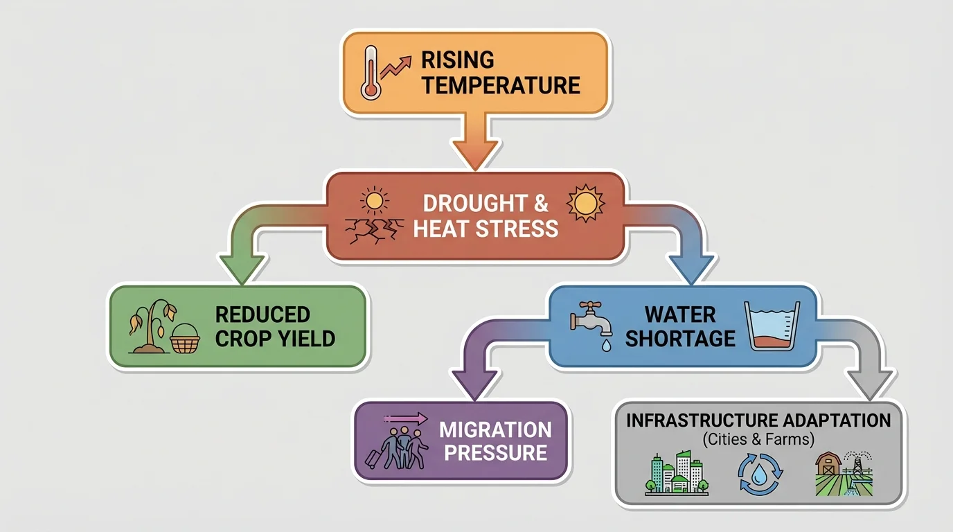
Consider agriculture. Crops depend on temperature, soil moisture, and predictable growing seasons. If a region becomes hotter and drier, farmers may need different crops, more irrigation, or new planting schedules. In some cases, yields may fall. In others, warming may lengthen growing seasons in colder regions. Climate change does not affect every place in exactly the same way.
Sea-level rise creates another major challenge. Coastal populations may face more frequent flooding, erosion, saltwater intrusion into groundwater, and damage from storm surge. Since many of the world's largest cities are coastal, even gradual change can have large social and economic effects. Ports, highways, sewage systems, and housing may all need redesign.
Numeric example: Estimating sea-level rise over time
Suppose a coastal location experiences an average sea-level rise of \(3 \textrm{ mm/year}\). Over \(20\) years, the total rise is found by multiplying rate by time.
Step 1: Write the relationship.
\(\textrm{sea-level rise} = \textrm{rate} \times \textrm{time}\)
Step 2: Substitute the values.
\(3 \textrm{ mm/year} \times 20 \textrm{ years} = 60 \textrm{ mm}\)
Step 3: Interpret the result.
\(60 \textrm{ mm} = 6 \textrm{ cm}\). Even a few centimeters can matter in low-lying coastal areas, especially during storms.
This simple calculation does not capture all local factors, but it shows how gradual change can add up.
Climate can also influence human movement. If water becomes unreliable or farmland less productive, people may move to other regions. These migrations can increase pressure on housing, jobs, and services elsewhere. In that way, environmental change in one region can influence politics and economics far beyond its borders.
Humans are not passive. We respond to Earth processes through technology, planning, and cooperation. Adaptation means adjusting to actual or expected environmental change. Examples include building sea walls, elevating structures, planting drought-tolerant crops, improving drainage systems, and creating evacuation routes.
Mitigation means reducing the causes or severity of a problem. In climate science, this often refers to lowering greenhouse gas emissions, increasing energy efficiency, or expanding renewable energy sources such as solar and wind. In hazard planning, mitigation can also include actions that reduce damage, such as stronger building codes or avoiding construction in floodplains.
Engineers use scientific evidence to design safer systems. In earthquake-prone regions, flexible materials and shock-absorbing foundations can reduce structural failure. In flood-prone regions, levees, retention basins, and restored wetlands can reduce flood risk. In drought-prone regions, irrigation efficiency and water recycling can extend limited supplies. These responses show that human activity is shaped by Earth systems, but also that scientific understanding can reduce vulnerability.
Cause and effect in Earth science is often complex. One event may have many effects, and one human outcome may result from several interacting factors, including resource distribution, hazard exposure, technology, and government decisions.
However, adaptation has limits. A city cannot infinitely expand if fresh water is insufficient. A coastline cannot always be defended at reasonable cost. Some communities may choose relocation instead of rebuilding. That choice itself becomes evidence of how Earth processes influence human activity.
To construct an explanation, start with a clear claim. For example: Access to reliable water supplies strongly influences where human settlements develop. Then provide evidence, such as the location of ancient river valley civilizations, modern irrigation systems, and population patterns near major rivers. Finally, add reasoning: water supports drinking, agriculture, sanitation, transportation, and industry, so areas with reliable water can support larger populations and more complex economies.
A similar structure works for hazards and climate. A claim might state that repeated flooding changes how people build and where they live. Evidence might include flood maps, damage records, insurance costs, and changes in zoning laws. Reasoning would connect those facts by showing that repeated flood damage makes certain land uses too risky or expensive, so communities adapt through relocation, engineering, or policy.
Model explanation using claim, evidence, and reasoning
Step 1: Claim
Natural hazards have influenced human activity in Japan by changing engineering and emergency planning.
Step 2: Evidence
Japan experiences frequent earthquakes, has recorded major damage from past events, and uses earthquake-resistant building designs and early warning systems.
Step 3: Reasoning
Because earthquakes cannot be prevented, repeated hazard exposure pushes societies to reduce risk through design, monitoring, and public preparation.
This explanation is stronger than a simple statement because it links observable evidence to a scientific conclusion.
When evaluating explanations, ask three questions: Is the claim specific? Is the evidence relevant and accurate? Does the reasoning clearly connect the evidence to the claim? That method helps separate strong scientific explanations from unsupported opinions.
Across history and in the present day, the same pattern appears again and again. People build near resources, cope with hazards, and adapt to climate. The map of river valleys in [Figure 1], the hazard relationships in [Figure 2], and the climate chain in [Figure 3] all point to the same conclusion: Earth processes help shape where people live, how they work, what they build, and when they move.