Why can one part of Earth be covered in ice while another grows bananas all year long? Our planet has many kinds of places, and each place has its own pattern of temperature, rain, wind, and clouds. These long-term patterns are what define a place's climate. When scientists study climate, they do not just look outside for one day. They gather information again and again, then combine what they learn to understand what a place is usually like.
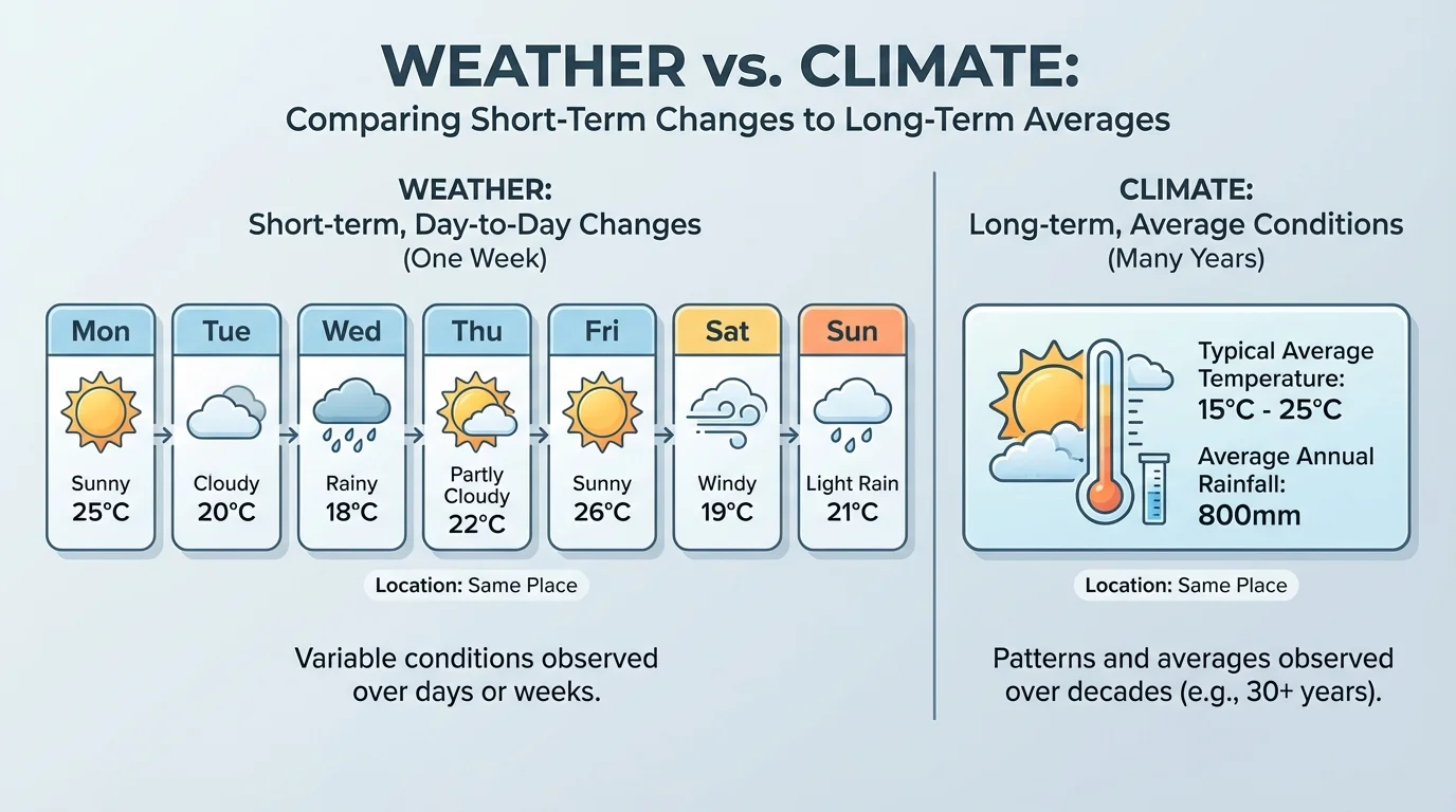
Weather is what the air is like at a certain time. It might be rainy this morning, sunny this afternoon, and windy tonight. Climate is the pattern of weather in a place over a long time. Climate tells us what usually happens there, as shown in [Figure 1], where daily weather changes but long-term patterns stay more steady.
Think about your closet. If you choose one shirt for today, that is like weather. If you look at all the clothes you wear during the whole year in your town, that is more like climate. A place with a hot, rainy climate often needs light clothing and umbrellas. A place with a cold climate needs coats, hats, and gloves much more often.
Scientists study climate by looking for patterns. They ask questions such as: Is this place usually warm or cold? Does it get a lot of rain or very little? Is it often snowy, dry, foggy, or windy? One storm or one sunny day does not tell the whole story. A pattern over many years gives a clearer picture.
Weather is the condition of the air at a certain time and place, such as sunny, cloudy, rainy, windy, hot, or cold.
Climate is the usual pattern of weather in a region over a long time.
Region is an area that shares some features, such as similar land, plants, or climate.
When people say, "It is usually hot and wet near the equator," they are talking about climate. When they say, "It rained hard this afternoon," they are talking about weather. This difference matters because climate helps us understand how places around the world are alike and different.
To understand a place, scientists observe it and collect information. They may measure temperature, keep track of rain or snow, read cloud cover, and notice wind. Then they record the information so they can look for patterns.
Scientists also use tools such as thermometers, rain gauges, maps, and charts. A thermometer tells temperature. A rain gauge measures how much rain falls. A map shows where places are on Earth. A chart helps people compare information quickly.
Sometimes information from many years is combined in a table. That makes it easier to describe climate clearly.
| Place | Typical Temperature | Typical Precipitation | Climate Characteristics |
|---|---|---|---|
| Amazon Rainforest | Warm | Very rainy | Wet most of the year |
| Sahara Desert | Hot | Very little rain | Very dry |
| London, England | Mild | Rain in many months | Often cloudy and damp |
| Antarctica | Very cold | Very little precipitation | Ice-covered and freezing |
Table 1. Examples of climate information from different world regions.
When students combine information, they might use a map to find a place, a chart to see temperature and rainfall, and pictures to observe plants or land. If a place has many palm trees, frequent rain, and warm temperatures, that information works together to support the idea that the region has a tropical climate.
Some deserts can be very cold at night even when they are hot in the daytime. A dry climate does not always mean a place is warm every hour of the day.
Climate studies often include temperature and precipitation. Temperature tells how hot or cold a place is. Precipitation means water that falls from clouds, such as rain or snow. These two kinds of information are especially useful because they help describe many climates around the world.
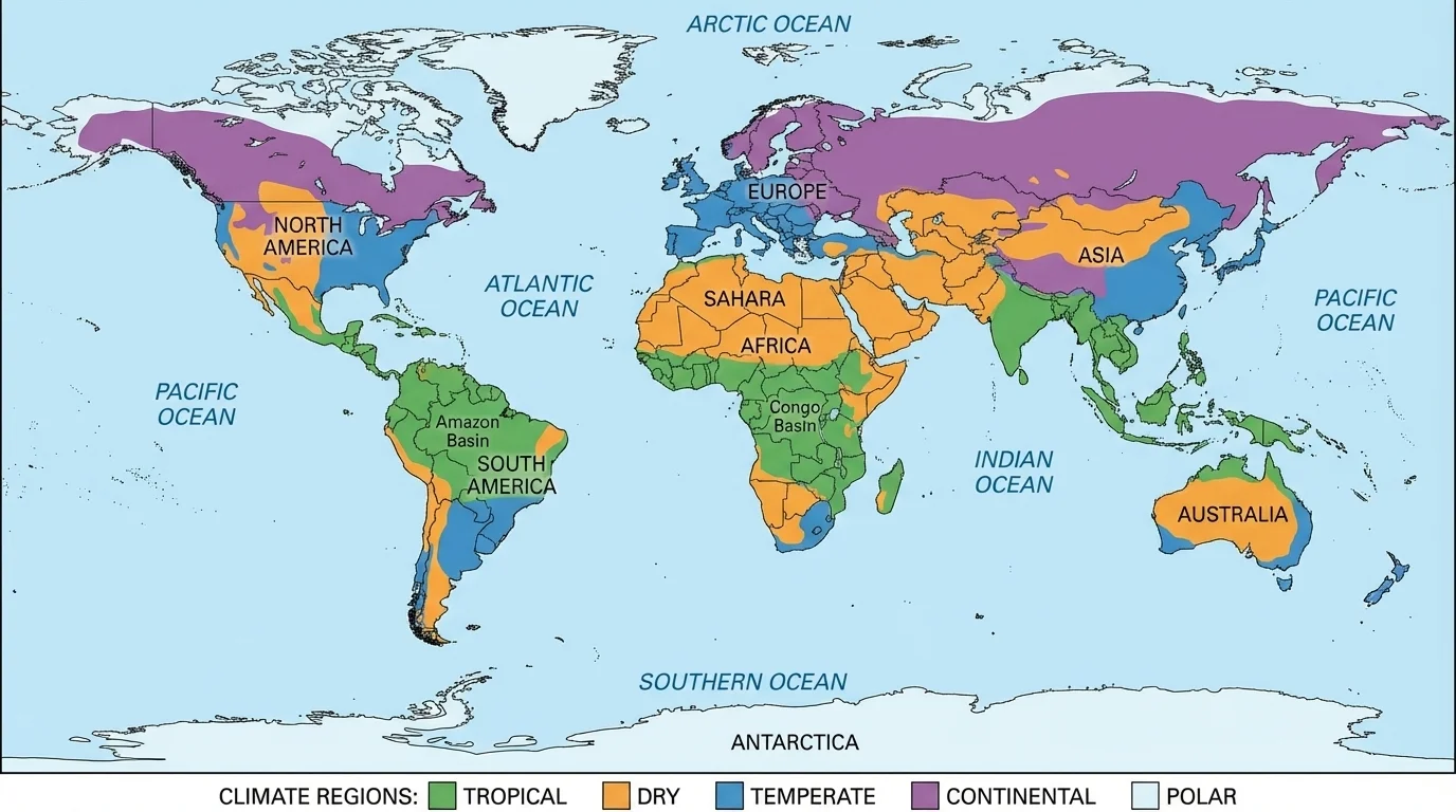
Earth has several broad climate regions. These are large areas where places share similar long-term weather patterns. A world map of these broad patterns, as seen in [Figure 2], helps us notice that climate is not random. There are patterns across continents and oceans.
One major kind is the tropical climate. Tropical regions are usually warm all year and often get a lot of rain. Many tropical places are near the equator. The Amazon Rainforest in South America is a strong example. It is warm, humid, and full of plant life.
Another kind is a dry climate. Dry regions get very little precipitation. Some dry climates are very hot, like the Sahara Desert in Africa. Others can be cooler. In dry places, plants often have special ways to save water.
A temperate climate is usually not extremely hot or extremely cold. It often has mild conditions. Many places with temperate climates get rain in different months of the year. Parts of Europe and some coastal areas of North America have temperate climates.
A continental climate is common in places far from large oceans. These regions often have bigger changes in temperature from one part of the year to another, with warm summers and cold winters. We can describe this pattern without explaining why seasons happen. Parts of central Asia and inland North America fit this climate type.
A polar climate is very cold. Polar regions are found near Earth's poles. Antarctica is one example. Greenland and the Arctic also have polar conditions. These places stay cold enough for ice and snow to last a long time.
Climate regions help scientists organize information. Instead of memorizing every place one by one, scientists group places with similar patterns. If two places are both warm and rainy most of the year, they may belong to the same broad climate region even if they are on different continents.
The map in [Figure 2] makes another important idea easier to see: one continent can have more than one climate. Africa includes tropical rainforest, dry desert, and milder coastal areas. North America includes dry deserts, temperate coasts, continental interiors, and polar regions in the far north.
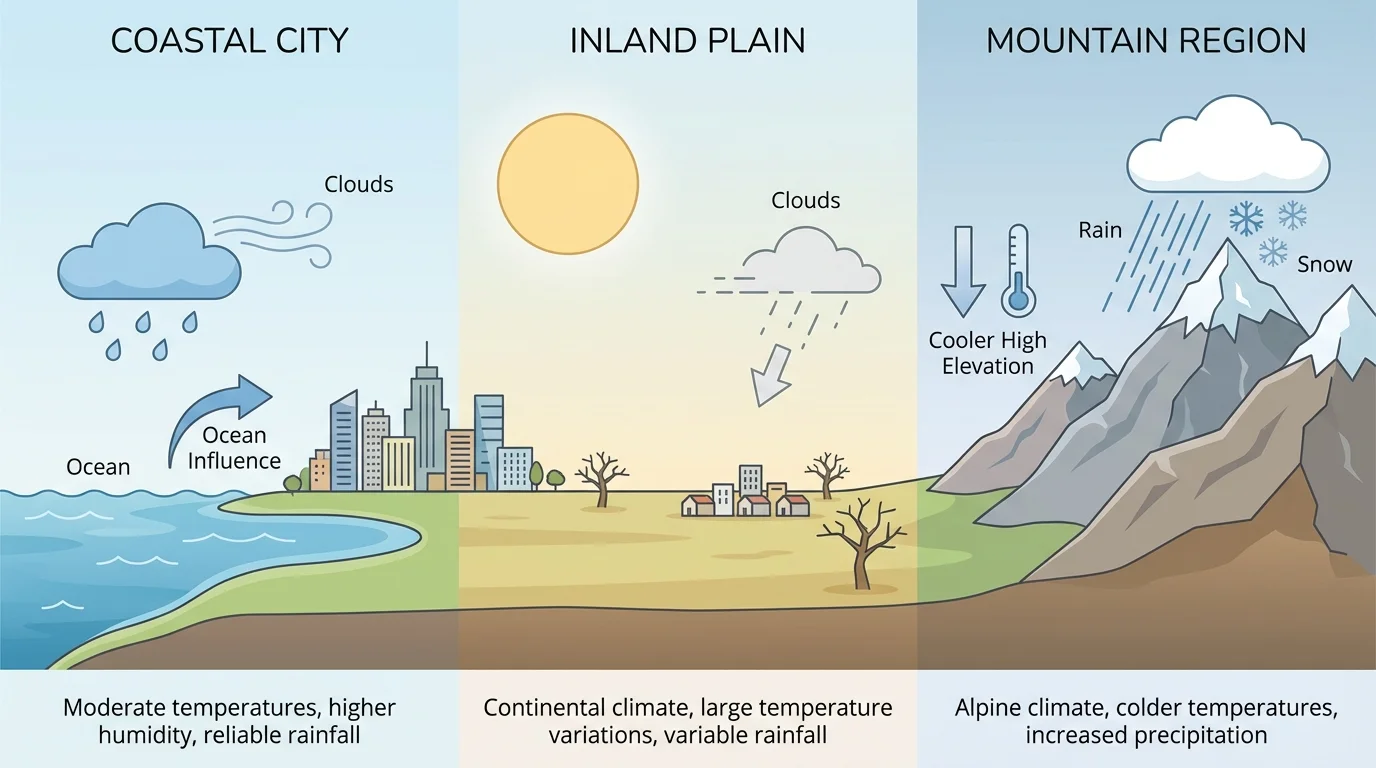
Climate depends on location. Scientists pay close attention to land and water because these features help explain why one region differs from another. A location comparison makes it easier to notice how coasts, inland areas, and mountains can have different climate patterns.
Places near large oceans or seas often have milder temperatures than places far inland, as shown in [Figure 3]. Water warms and cools more slowly than land. That means coastal regions may not get as extremely hot or cold as inland places. They may also have more moisture in the air.
Mountains also affect climate. High places are often cooler than lower places. Mountains can also affect where rain or snow falls. One side of a mountain may be wetter, while another side may be drier.
Distance from water matters too. A city near the coast may have a mild climate, but a city deep inside a continent may have a more extreme climate. This is one reason climate can change as you travel across the same landmass.
These clues help scientists combine information. If a place is near the ocean, has frequent rain, and does not get very hot or very cold, it may have a temperate climate. If a place is far inland and has bigger temperature changes, it may have a continental climate. The comparison in [Figure 3] helps connect location with these climate patterns.
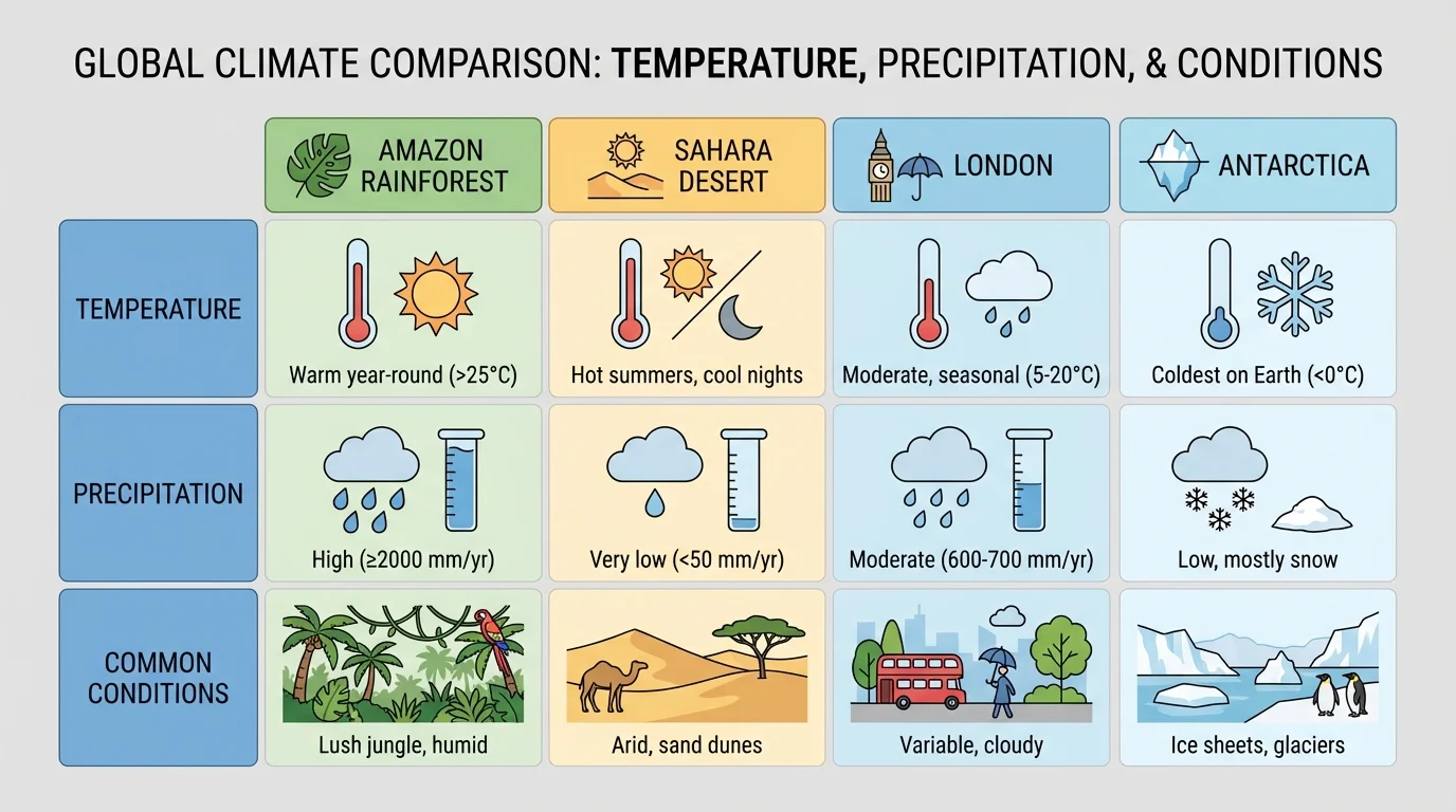
To describe climates well, scientists do not use just one fact. They combine temperature, precipitation, maps, and observations. A comparison chart, as shown in [Figure 4], helps us study several world regions side by side and explain how they are similar or different.
The Amazon Rainforest in South America has a tropical climate. It is warm and rainy through much of the year. Because there is so much water and warmth, many plants grow there. Tall trees, vines, and many animals can survive in this wet region.
The Sahara Desert in Africa has a dry climate. It is famous for getting very little rain. Daytime temperatures can be very hot. Plants and animals there must be able to live with little water.
London, in England, has a temperate climate. It is often mild rather than extremely hot or cold. Rain falls in many months, and cloudy skies are common. The climate supports grass, trees, and farms.
Antarctica has a polar climate. It is extremely cold and covered with ice. Very few plants grow there. Animals that live nearby, such as penguins and seals, are suited for cold conditions.
Combining information to describe one region
Suppose you want to describe the climate of a place that is warm all year, gets rain in most months, and has thick forests.
Step 1: Look at temperature.
The place is warm most of the time, so it is not polar and probably not continental.
Step 2: Look at precipitation.
The place gets a lot of rain, so it is not a dry climate.
Step 3: Add observations.
Thick forests and many green plants suggest lots of water and warmth.
Step 4: Make a claim using evidence.
The region most likely has a tropical climate.
This is how scientists and students combine clues instead of guessing from only one detail.
The chart in [Figure 4] also shows that not all cold places are the same as dry places, and not all warm places are rainy. Temperature and precipitation work together to describe climate more clearly.
Climate affects living things and the choices people make. In tropical climates, thick forests and many kinds of animals are common. In dry climates, plants such as cacti or grasses may be better suited to the conditions. In polar climates, only certain plants and animals can survive.
People also adapt to climate. Homes in snowy places may have steep roofs so snow can slide off. In hot, dry places, buildings may have thick walls or small windows to stay cooler. Clothes, transportation, farming, and even daily schedules can be affected by climate.
Farmers pay close attention to climate because plants need the right amount of warmth and water. Rice grows well in some warm, wet regions. Wheat may grow better in places with different conditions. Climate does not control everything, but it gives important clues about what can grow where.
Antarctica is a frozen desert. It is extremely cold, but it also gets very little precipitation, which means it fits both the idea of being icy and being very dry.
Animals are also linked to climate. Camels are well suited to dry deserts. Polar bears are suited to cold Arctic regions. Monkeys, parrots, and many insects live in tropical rainforests. The climate of a place helps shape the kinds of life found there.
When you describe a region's climate, use evidence words such as usually, often, and most years. These words remind us that climate is about patterns, not one single day. A temperate place can still have a very hot day. A dry region can still get rain once in a while.
Good climate descriptions include more than one fact. For example, saying "This place is warm" is not enough by itself. A stronger description is: "This region is usually warm and rainy, so it has a tropical climate." Another strong description is: "This inland region has less moisture and bigger temperature changes, so it has a continental climate."
Scientists often compare one region with another. If two places are both near the equator, they may both be warm, but one may be a rainforest and the other may be drier. That is why combining information matters. A map tells location, a chart gives temperature and precipitation, and observations show what the land and living things are like.
When students learn to obtain and combine information, they are doing an important part of science. They are using evidence to explain the natural world. Climate is a powerful example because it connects the air, water, land, plants, animals, and human life all across Earth.