One remarkable feature of Earth is that the air above us can behave like a vast moving layer. In just a day, the sky can shift from bright and calm to stormy and cold, not because the atmosphere is random, but because huge bodies of air are constantly traveling, colliding, rising, sinking, and exchanging heat and moisture. Weather changes provide important clues. If we collect the right data, we can use those clues as evidence to explain what the atmosphere is doing.
Weather is the condition of the atmosphere at a certain place and time. It includes things people can observe and measure, such as temperature, wind, humidity, air pressure, and precipitation. Weather can change quickly because the atmosphere is always moving. Air does not stay still over one spot for long.
A place may feel warm and humid one afternoon, then cool and dry the next morning. That kind of change often happens when a air mass moves into the area. An air mass is a large body of air with similar temperature and moisture throughout it. Because air masses are so large, they can affect weather over entire states, regions, or even larger areas.
Temperature tells how warm or cool the air is, and humidity describes how much water vapor is in the air. Water vapor is water in the form of an invisible gas, and it is a key part of weather because it can later condense into droplets and fall as precipitation.
To explain weather scientifically, we do more than say, "It looks stormy." We gather evidence. For example, if temperature drops, wind direction changes, air pressure shifts, and rain begins within a few hours, those measurements together can point to an air mass interaction rather than a random event.
[Figure 1] Air masses form when air stays over one region long enough to take on that region's conditions. If air sits over a warm ocean, it becomes warmer and moister. If it remains over a cold land area, it becomes colder and drier. The place where an air mass forms is called its source region.
Source regions are usually broad areas with fairly even conditions, such as oceans, deserts, snowy plains, or large forests. Because oceans provide lots of evaporating water, air masses over oceans often become humid. Land areas usually provide less moisture than oceans, so air masses forming over land are often drier.
When meteorologists describe air masses, they often focus on two major features: temperature and moisture. These features matter because they influence cloud formation, precipitation, and how comfortable or uncomfortable the air feels to people.
Air mass means a large body of air that has similar temperature and moisture throughout. Source region means the area where that air mass forms and gains its main characteristics. Density means how much matter is packed into a given space; colder air is usually denser than warmer air.
Cold air masses are usually denser than warm air masses. This density difference is a major reason weather changes when air masses meet. Denser air tends to stay lower, while less dense warm air is more likely to rise. Rising air is important because it cools as it rises, and cooling can lead to condensation and cloud formation.
The Sun does not heat Earth evenly. Areas near the equator receive more direct sunlight than areas near the poles, and land and water heat at different rates. These uneven heating patterns create differences in temperature and pressure. Air moves from areas of higher pressure toward areas of lower pressure, and that movement creates wind.
Air pressure is the force caused by the weight of air pressing down. Even though we cannot usually feel this pressure directly, measuring changes in pressure gives scientists strong evidence about changing weather. A falling pressure often suggests rising air and developing unsettled weather. A rising pressure often suggests sinking air and calmer conditions.
Density helps explain why different air masses do not simply blend instantly. Cold, dense air tends to push underneath warmer, less dense air. Humidity also matters. Moist air can lead to cloud formation and precipitation when it is lifted and cooled enough for water vapor to condense into tiny droplets.
Why rising air matters
When air rises, it expands because pressure is lower higher in the atmosphere. As it expands, it cools. If the air cools to the point where water vapor condenses, clouds form. If enough droplets or ice crystals grow, precipitation can fall. This is why places where air is forced upward often experience changing weather.
Think about opening a cold drink on a humid day. Water droplets form on the outside because nearby water vapor cools and condenses. In the atmosphere, a similar process happens on a much larger scale when moist air rises and cools.
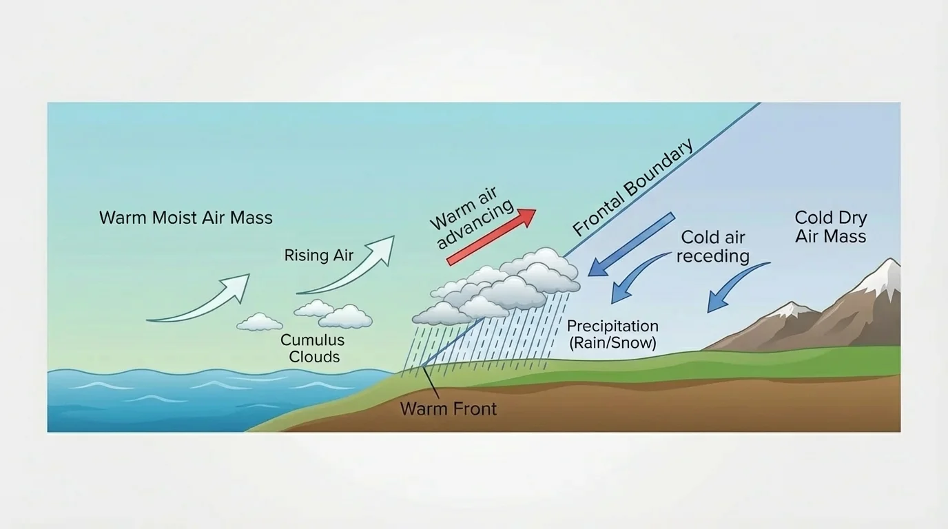
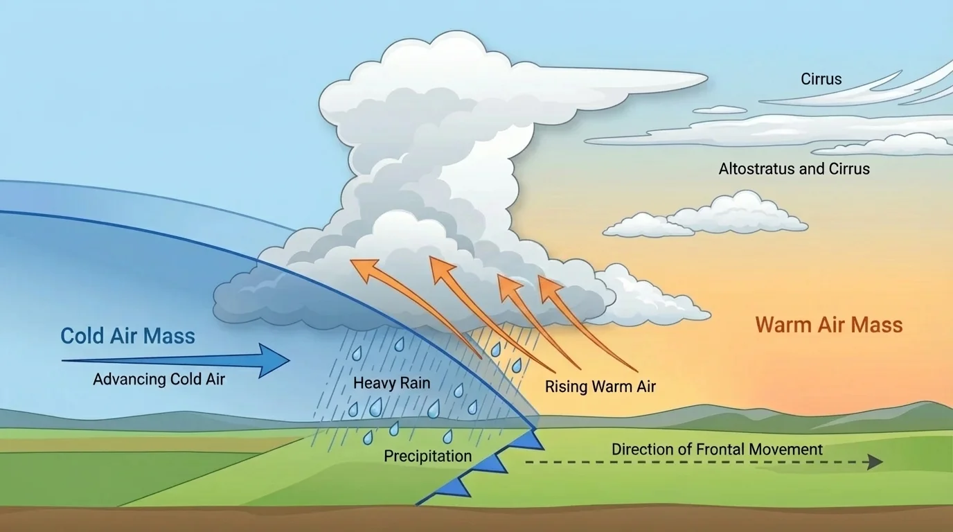
[Figure 2] The boundary where two air masses meet is called a front, and this is where weather often changes quickly. Fronts are important because the air masses on each side usually differ in temperature, moisture, and density.
A cold front happens when a colder, denser air mass moves toward a warmer air mass. The cold air wedges under the warm air and forces the warm air upward. Because rising warm air cools, clouds and precipitation may develop quickly. Temperature often drops after the front passes, and wind direction may change.
A warm front happens when a warmer air mass moves toward cooler air. Because warm air is less dense, it gradually rises over the cooler air. Weather changes with warm fronts can be more spread out over time, often bringing increasing clouds and steady precipitation before warmer conditions arrive.
A stationary front forms when two air masses meet but neither one moves very far. This can lead to cloudy or rainy weather that lasts longer in one place. An occluded front forms when a cold front overtakes a warm front, creating more complex lifting and mixing. You do not need to memorize weather-map symbols for these fronts; what matters is understanding that boundaries between different air masses often lead to rising air and changing weather.
Notice how the idea of density connects back to the air masses in [Figure 1]. The properties an air mass gained in its source region help determine what happens when it meets another one.
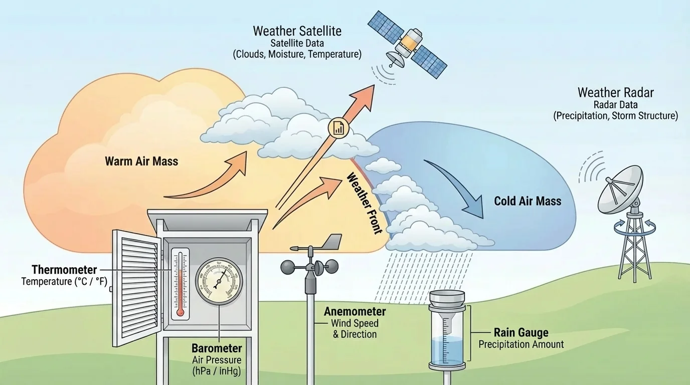
[Figure 3] Scientists do not guess what air masses are doing. They collect evidence from repeated measurements, and this figure highlights some of the main types of weather data. Good explanations of weather are based on patterns in these measurements over time.
Important weather data include temperature, humidity, air pressure, wind speed, wind direction, cloud cover, and precipitation. Meteorologists also use radar, satellites, weather balloons, and ground stations. Each tool adds a different kind of evidence.
A thermometer measures temperature. A barometer measures air pressure. An anemometer measures wind speed. A rain gauge measures how much precipitation falls. Satellites provide broad views of cloud patterns and large storm systems. Radar helps detect where precipitation is occurring and how it is moving.
If a weather station records a temperature drop from \(24^\circ\textrm{C}\) to \(16^\circ\textrm{C}\), a wind shift from south to northwest, and a pressure rise over several hours, that combination is evidence that a colder air mass may have moved in. One measurement alone might not prove much, but several measurements together can tell a stronger story.
| Data collected | What it tells scientists | Possible clue about air masses |
|---|---|---|
| Temperature | Whether the air is warming or cooling | Arrival of warmer or colder air |
| Humidity | How much water vapor is present | Moist or dry air mass moving in |
| Air pressure | Whether air is rising or sinking more strongly | Developing storms or clearing weather |
| Wind direction | Where the air is coming from | Shift in air-mass source |
| Precipitation | Whether condensed water is falling | Lifting air near a front |
Table 1. Common weather measurements and how they provide evidence about moving air masses.
A weather forecast for your town may use information gathered from the ground, from balloons rising through the atmosphere, from ocean buoys, and from satellites orbiting high above Earth.
Because weather changes over time, one of the most important scientific habits is to collect data again and again. A single observation is a snapshot. A series of observations is evidence of change.
When scientists examine weather data, they look for patterns. For example, warm, humid air before a cold front may be followed by darkening skies, gusty winds, a quick burst of rain or thunderstorms, then cooler and drier air after the front passes. This sequence is more useful than any one fact by itself.
If pressure falls steadily, clouds increase, and humidity rises, the atmosphere may be moving toward stormier conditions. If pressure rises, skies begin to clear, and drier air arrives, the weather may be improving. Scientists compare these patterns with radar, satellite images, and reports from different locations to see how an air mass is moving.
Case study: A day of changing weather
A middle school class records conditions every two hours.
Step 1: Morning data
At \(8 \textrm{ a.m.}\), the temperature is \(22^\circ\textrm{C}\), humidity is high, wind blows from the south, and pressure is slowly falling.
Step 2: Midday data
By noon, clouds thicken, wind becomes gustier, and light rain begins.
Step 3: Afternoon data
At \(4 \textrm{ p.m.}\), the temperature has dropped to \(15^\circ\textrm{C}\), wind now blows from the northwest, and pressure is rising.
These observations are strong evidence that a cold air mass likely replaced a warmer, more humid air mass.
The diagram of a cold front in [Figure 2] helps explain why those measurements change together. The rising warm air can produce precipitation, while the advancing cold air lowers temperature and often changes wind direction.
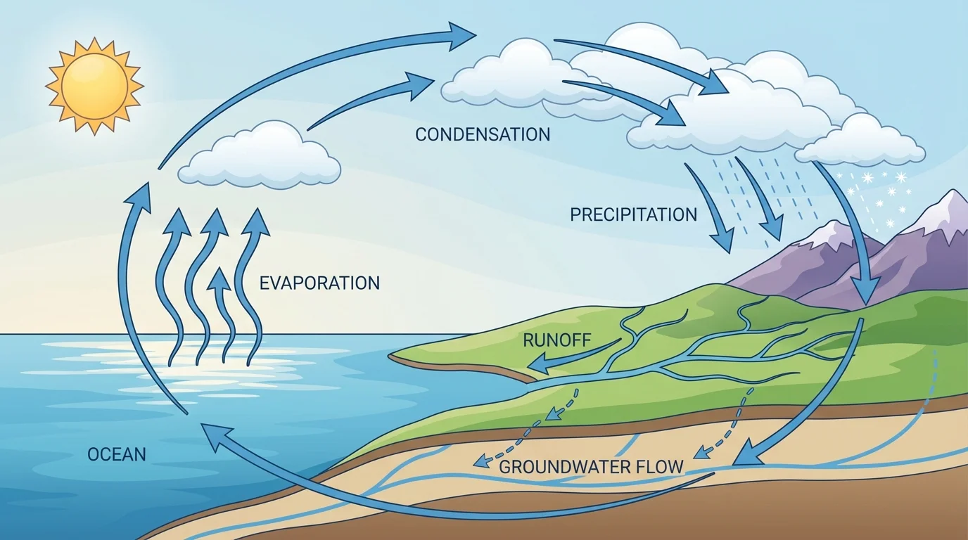
[Figure 4] Air masses are not just moving air. They also transport water vapor through the atmosphere, and this process connects directly to the water cycle. Water cycles among ocean, land, and atmosphere, driven mainly by sunlight and gravity.
Sunlight causes evaporation, especially from oceans, lakes, rivers, and wet soil. During evaporation, liquid water becomes water vapor and enters the air. Winds and moving air masses carry that vapor from one place to another. When air rises and cools, condensation occurs, forming cloud droplets. Gravity then pulls precipitation back to Earth as rain, snow, sleet, or hail.
This connection explains why oceans are so important to weather. Air masses that form over oceans often contain more moisture because evaporation supplies water vapor. If those moist air masses move over land and are lifted by a front or by mountains, precipitation may increase.
How weather links to changing landscapes
Precipitation from air-mass interactions does more than affect whether people need umbrellas. Flowing water can weather rock, carry sediment, and reshape land over time. Heavy rainfall can cause erosion on hillsides, riverbanks, and bare soil. In this way, atmospheric processes connect directly to changing landforms.
The moisture source shown earlier in [Figure 1] matters here too. An air mass coming from the ocean starts with a very different water-vapor supply than one forming over a cold, dry interior land region.
In the central United States, warm, moist air from the Gulf of Mexico often meets colder, drier air from the north or west. These interactions can produce powerful thunderstorms, especially when warm air is forced to rise rapidly. Meteorologists watch temperature, humidity, wind, and pressure data carefully in such situations.
Along coastlines, sea breezes provide another example of moving air. During the day, land heats faster than water. Warmer air over land rises, and cooler air from over the water moves inland. This smaller-scale movement is not the same as a giant continental air mass, but it shows the same ideas of uneven heating, pressure differences, and moving air.
In winter, when very cold air moves over a warmer lake, the lower air can pick up moisture and heat from the water. As that air moves over land and rises, it can produce heavy snowfall in certain areas. Again, the weather outcome depends on the interaction between moving air and water sources.
Evidence from a coastal weather change
A town near the ocean records these conditions over one afternoon: temperature inland rises quickly, winds begin blowing from the sea, and humidity near shore increases.
Step 1: Identify the heating difference
Land warms faster than ocean water in daylight.
Step 2: Explain air movement
Air over land rises, and cooler marine air moves inland.
Step 3: Connect to weather
The incoming air is often cooler and moister, which can change local temperature and cloudiness.
This is a local example of how moving air and water sources work together to change weather.
These examples show why weather forecasting matters for farmers, pilots, sailors, truck drivers, and emergency managers. A shift in an air mass can affect crops, flights, road safety, and flood risk.
You can understand air masses better by collecting weather evidence over several days in one location. Record temperature, wind direction, cloud cover, humidity if available, and whether precipitation occurs at the same times each day. Then compare your observations with a local forecast.
Suppose you gather data for four days and notice this pattern: Day 1 is warm and humid, Day 2 becomes cloudier with falling pressure, Day 3 brings rain and gusty winds, and Day 4 is cooler and drier with rising pressure. That pattern supports the explanation that a front passed and one air mass replaced another.
| Day | Temperature trend | Humidity | Pressure trend | Likely interpretation |
|---|---|---|---|---|
| \(1\) | Warm | High | Slowly falling | Moist air mass present |
| \(2\) | Slightly cooler | Still high | Falling more | Front approaching |
| \(3\) | Dropping | Rain occurring | Lowest, then rising | Front passing |
| \(4\) | Cool | Lower | Rising | New drier air mass present |
Table 2. A sample pattern of weather data that can be used as evidence for a passing front and changing air masses.
Scientists value this kind of evidence because it is based on observations, not guesses. The more carefully data are collected, the more confidently scientists can explain why weather changes happened.
Weather forecasts help people make decisions every day. Schools decide whether outdoor activities are safe. Farmers use forecasts to protect crops. Pilots and ship captains need to know about wind, storms, and visibility. Communities use storm warnings to prepare for flooding or severe weather.
Better understanding of air masses also helps explain long-term effects on Earth systems. Repeated storms can increase runoff, which moves soil and sediment. Rain and flowing water can break down rock and reshape land. In this way, atmosphere, water, and land are connected parts of one changing Earth system.
When meteorologists use instruments, compare data from many places, and study how air masses move and interact, they are doing what scientists do best: using evidence to explain natural events. Weather is not just something that happens to us. It is something we can investigate, measure, and understand.