A desert can be freezing at night, a coastal city can stay mild in winter, and two towns at the same latitude can have very different climates. That seems strange at first, but Earth is not controlled by just one factor. Weather and climate are shaped by a whole set of connected systems: sunlight, air, water, ice, land, and living things. When these systems interact, they create the patterns we experience as winds, storms, seasons, droughts, monsoons, and long-term climate zones.
Weather is the condition of the atmosphere over a short time. It includes things like temperature, clouds, wind, humidity, and precipitation today or this week. Climate is the usual pattern of weather in a place over many years. If a city is usually hot and rainy in summer, that is part of its climate. If it has one rainy afternoon, that is weather.
Scientists often study climate by looking at averages and patterns over decades. A snowstorm in one winter does not prove a place has a cold climate, just as one hot day does not prove a place has a hot climate. Climate is about long-term trends.
Weather is the day-to-day condition of the atmosphere in a place.
Climate is the long-term pattern of weather in a region.
Latitude is the distance north or south of the equator.
Altitude is the height of a place above sea level.
To understand climate, we have to think like Earth system scientists. They ask: How much solar energy reaches a place? How much water is nearby? Are there mountains? Is the land covered with forest, ice, or city streets? All of these matter.
The biggest source of energy for Earth's surface is the Sun. But sunlight does not heat every place equally. At low latitudes near the equator, sunlight strikes more directly, as [Figure 1] shows, so the same amount of solar energy is concentrated into a smaller area. Near the poles, sunlight arrives at a lower angle and spreads out over a larger area, so less energy warms each square meter of ground or water.
This uneven heating is one of the main reasons Earth has tropical, temperate, and polar climate zones. It also helps drive movement in the atmosphere and ocean. Warm regions gain more energy, cooler regions gain less, and Earth's systems are always moving energy from warmer places toward cooler places.
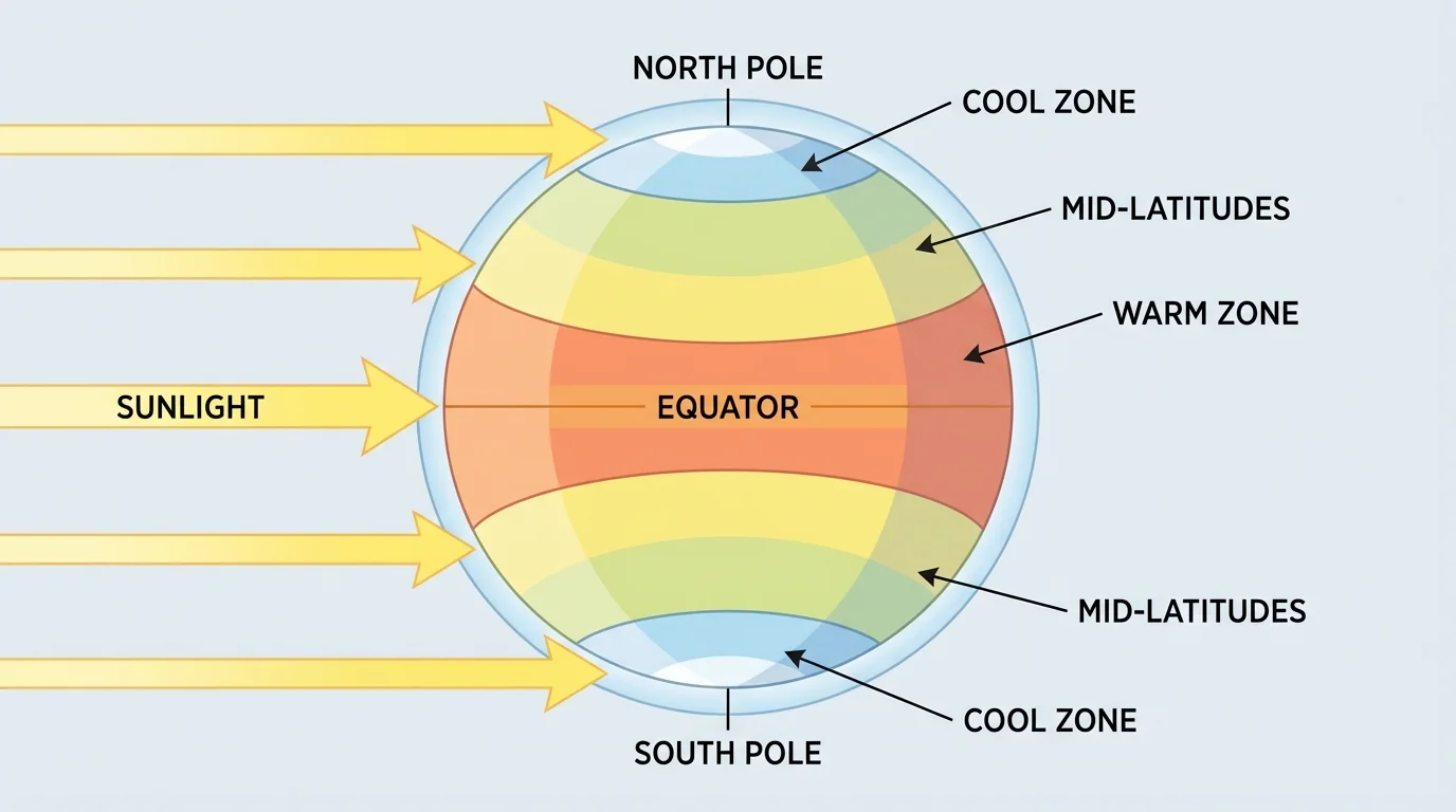
Earth's tilt also matters. As Earth orbits the Sun, different parts of the planet receive more direct sunlight during different times of year. That creates seasons. However, the strength of seasons depends on location. Near the equator, temperatures may stay warm all year. At higher latitudes, the differences between summer and winter can be much larger.
Surface type changes what happens to solar energy. Dark ocean water usually absorbs more energy than bright ice or snow, which reflect much of it. This means sunlight begins the process, but what the surface is made of affects how much warming actually happens.
The equator is not always the hottest place on Earth every day. Dry deserts at subtropical latitudes can become hotter than many equatorial forests because cloud cover, moisture, and surface type also affect temperature.
A simple energy idea helps explain warming. If incoming solar energy is greater than outgoing energy, a surface warms. If outgoing energy is greater, it cools. For example, if a surface receives about \(300 \textrm{ units}\) of energy and loses \(250 \textrm{ units}\), the net gain is \(300 - 250 = 50\), so the surface warms.
The atmosphere is the layer of gases surrounding Earth. It contains mostly nitrogen and oxygen, along with small amounts of gases such as \(\textrm{CO}_2\) and water vapor. Even though some gases are only a small part of the atmosphere, they can have a big effect on climate.
Air moves because of differences in heating and pressure. Warm air becomes less dense and rises. Cooler air is denser and sinks. As air rises, cools, and sinks in different places, it creates circulation patterns and wind. Wind is simply moving air caused by differences in air pressure.
When warm air rises near the surface, cooler air often moves in to take its place. This movement helps transfer heat around Earth. On a small scale, it can create sea breezes and land breezes. On a much larger scale, it helps build global wind belts.
Why moving air matters
The atmosphere does not just sit above Earth like a blanket. It is constantly flowing. Those flows move heat, moisture, and clouds from one region to another. Without moving air, the tropics would become much hotter and the poles much colder.
The atmosphere also holds water vapor. When water vapor condenses into liquid droplets, clouds form. When droplets grow large enough, precipitation falls as rain, snow, sleet, or hail. So the atmosphere links heat and water together.
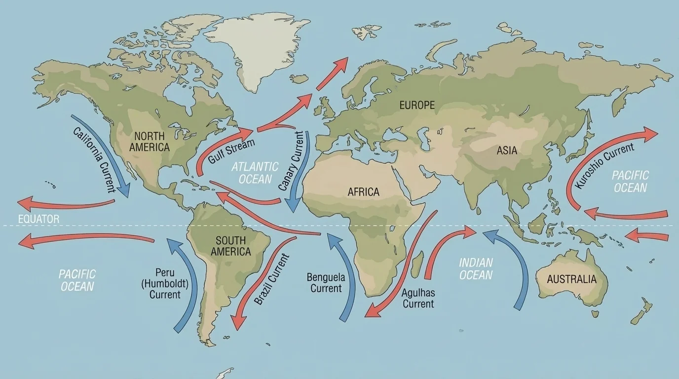
An ocean current is a moving flow of ocean water that helps carry heat around the planet, and together these currents, as [Figure 2] illustrates, redistribute energy across Earth. The ocean absorbs huge amounts of solar energy, especially near the tropics, and releases heat more slowly than land. That is why coastal places often have milder temperatures than inland places.
Water has a high heat capacity, which means it takes a lot of energy to change its temperature. Land heats and cools more quickly. If you have ever noticed that beach sand can feel hot during the day while nearby ocean water stays cooler, you have experienced this difference.
Surface currents move warm and cool water from one region to another. Warm currents can raise temperatures along nearby coasts, while cold currents can cool them. For example, western Europe is milder than some other places at similar latitudes partly because warm Atlantic waters help transfer energy there. On the other hand, cold currents can help create cool, dry coastal conditions.
The ocean and atmosphere are tightly connected. Wind pushes surface water, and the movement of water affects the air above it. Warm ocean water can add heat and moisture to the atmosphere, helping storms grow stronger. This is one reason tropical storms often become more powerful over warm water.
Deep ocean currents also matter, although they move more slowly than surface currents. Differences in temperature and salinity help drive this deep circulation. Together, surface and deep currents redistribute energy around the globe.
Real-world example: Why coasts are often milder
Compare an inland city and a coastal city at similar latitude.
Step 1: Land heats quickly in summer and cools quickly in winter.
Step 2: The nearby ocean changes temperature more slowly, so it stores summer heat and releases it gradually.
Step 3: Winds from the ocean help moderate temperatures along the coast.
As a result, the coastal city often has cooler summers and warmer winters than the inland city.
Later, when we look at regional differences, the current patterns in [Figure 2] help explain why some coastlines are wetter, milder, or foggier than others.
Water vapor is invisible water in the gas state. It enters the air through evaporation from oceans, lakes, soil, and plants. When water vapor cools, it can condense into tiny droplets or ice crystals, forming clouds.
This movement of water through evaporation, condensation, precipitation, and runoff is part of the water cycle. It is also part of climate. Places with warm oceans and rising air often receive heavy rainfall. Places where air sinks may stay dry.
Water changes weather because phase changes involve energy. When liquid water evaporates, it absorbs energy. When water vapor condenses, it releases energy into the atmosphere. That released energy can strengthen storms. A simple example is this: if evaporating water absorbs \(10\) units of energy, condensing that same amount of water releases about \(10\) units back into the surrounding air.
Humidity matters too. Humid air already contains a lot of water vapor, so sweat evaporates more slowly from your skin. That is why hot, humid weather can feel much more uncomfortable than hot, dry weather.
Albedo is a measure of how much sunlight a surface reflects. Ice and snow have high albedo, so they reflect a large fraction of incoming sunlight. Dark ocean water and forests usually have lower albedo, so they absorb more energy.
This means ice and snow can cool Earth by reflecting sunlight. But if ice melts, darker surfaces are exposed. Those darker surfaces absorb more solar energy, which can lead to more warming and even more melting. That is a feedback loop, where a change leads to effects that increase the original change.
Why polar regions are especially sensitive
Polar climates are strongly affected by ice, snow, and seasonal sunlight. When reflective ice shrinks, the change affects both local temperature and larger flow patterns in the atmosphere and ocean. A change in one part of the Earth system can spread through the others.
Sea ice, glaciers, and ice sheets are not the same thing. Sea ice forms from frozen ocean water. Glaciers and ice sheets form on land from compacted snow. All of them influence climate, but in somewhat different ways.
Changes in ice cover can affect animals and people too. Species that depend on sea ice habitat may struggle if that ice shrinks. Melting land ice can add water to the ocean and contribute to sea level rise, which affects coastal communities.
Topography, which means the shape of the land, strongly influences local climate. Mountains, valleys, plateaus, plains, and coastlines affect how air moves and where precipitation falls. Mountains are especially important because they force air upward, as [Figure 3] shows.
When moist air blows toward a mountain, it rises along the windward side. As it rises, it cools. Cooler air holds less water vapor, so clouds and precipitation often form. After the air crosses the mountain and sinks down the leeward side, it warms and dries. This can create a dry region called a rain shadow.
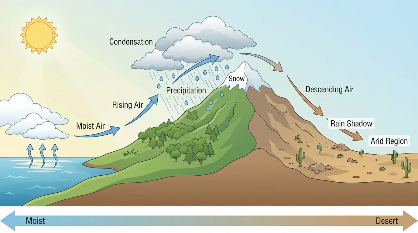
That is why one side of a mountain range can be green and wet while the other side is dry. This pattern appears in many parts of the world. Mountains do not just affect precipitation; they can also block cold air, channel winds through valleys, and create different climates at different elevations.
Distance from large bodies of water matters too. Inland places often have bigger temperature swings because they do not get the moderating effect of the ocean. Local geography, such as being in a valley or on a hilltop, can also affect temperature, fog, and wind.
Case study: Mountain weather
A town on the windward side of a mountain range and a town on the leeward side may be only a short distance apart, but they can have very different climates.
Step 1: Moist ocean air moves toward the mountains.
Step 2: Rising air cools, clouds form, and rain or snow falls on the windward side.
Step 3: Drier air descends on the leeward side and warms.
The windward town may have forests and streams, while the leeward town may be much drier, sometimes even desert-like.
The pattern in [Figure 3] helps explain why many famous deserts lie downwind of mountain ranges.
Living things are part of Earth's climate system too. Plants absorb \(\textrm{CO}_2\) during photosynthesis and release water vapor through a process called transpiration. Large forests can influence humidity, cloud formation, and even local rainfall.
Different ecosystems affect climate in different ways. Grasslands, forests, wetlands, and tundra each interact with sunlight, water, and carbon differently. For example, a forest usually shades the ground and releases moisture into the air, while a dry bare surface may heat up faster.
Humans are living things that influence climate as well. Cutting forests, building cities, and burning fossil fuels can change the atmosphere and land surface. Cities often create urban heat islands, where pavement and buildings absorb and release more heat than nearby rural land.
Some large forests help create part of their own rainfall. Water released by plants can return to the atmosphere, form clouds, and fall again as rain.
Living things do not control climate by themselves, but they are important parts of the system. The biosphere, atmosphere, hydrosphere, geosphere, and cryosphere all interact.
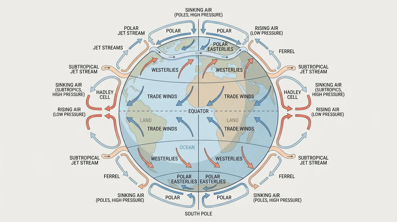
On the scale of the whole planet, Earth has large atmospheric flow patterns caused by uneven heating, rotation, and differences in pressure. These patterns include rising air near the equator, sinking air in subtropical regions, and strong high-altitude winds called jet streams.
[Figure 4] Jet streams are fast-moving bands of air high in the atmosphere. They help steer weather systems. If the jet stream shifts, storms and temperature patterns can shift too. This is one reason weather can change over large regions from week to week.
Ocean-atmosphere patterns can also affect weather over many months. One important example is El Niño, when parts of the tropical Pacific Ocean become warmer than usual. That extra warmth can change rainfall and storm tracks in regions far away. La Niña is the opposite pattern, with cooler-than-usual waters in the same area.
These flow patterns show that weather in one place may be connected to conditions far away. A change in ocean temperature in one part of the world can influence atmospheric circulation elsewhere.
The circulation cells and wind belts in [Figure 4] also help explain why many deserts form near subtropical latitudes, where sinking air tends to limit cloud formation and rainfall.
Now we can put the pieces together. Climate depends on many interacting factors: latitude, altitude, sunlight, oceans, winds, ice, landforms, and living things. No single factor explains everything.
Altitude has a major effect on temperature. In general, higher places are cooler than lower places. Even in tropical regions, high mountains can have snow near their peaks. If one location is at sea level and another is high in the mountains, the higher location is usually cooler because the air is thinner and holds less heat.
Latitude and altitude can combine in interesting ways. A city near the equator may still have a mild climate if it is high in the mountains. A city far from the equator may be warmer than expected if warm ocean currents affect its coast.
| Factor | How it affects climate | Example effect |
|---|---|---|
| Latitude | Changes the angle and intensity of sunlight | Equatorial regions are usually warmer than polar regions |
| Altitude | Higher elevations are usually cooler | Mountain towns can be cooler than nearby lowlands |
| Distance from ocean | Water moderates temperature | Coastal climates are often milder |
| Ocean currents | Move warm and cool water | Warm currents can make nearby coasts milder |
| Topography | Mountains and valleys change wind and precipitation | Rain shadows create dry leeward regions |
| Ice and snow | Reflect sunlight | High albedo can cool a region |
| Living things | Change moisture, gases, and surface cover | Forests can increase local humidity |
Table 1. Major factors that influence local and regional climate patterns.
Think about a few case studies. A coastal city in California may be cooler and drier than an inland desert because of cold ocean currents and marine air. A city in the Andes can be cool despite being near the equator because of high altitude. A tropical rainforest is warm and wet because intense sunlight, abundant water, and plant transpiration all work together.
Scientists study weather and climate using thermometers, rain gauges, satellites, weather balloons, ships, and ocean buoys. They measure temperature, wind speed, air pressure, humidity, sea surface temperature, ice cover, and more.
These observations are used in computer models to predict weather and understand climate patterns. Forecasting weather is difficult because the atmosphere changes quickly. Climate studies focus more on patterns, averages, and long-term trends. Both depend on understanding interactions among Earth's systems.
Earth's systems include the atmosphere, hydrosphere, geosphere, biosphere, and cryosphere. Weather and climate make sense when these systems are studied together rather than one at a time.
When scientists predict that a region may become wetter, drier, stormier, or warmer, they are looking at system interactions. They consider sunlight, circulation patterns, ocean temperature, land cover, ice, and geography all at once.