How do video games know exactly where a character stands? How do city planners mark the corners of a new park? One powerful answer is coordinates. A coordinate plane works like a map with number lines, and each point has a precise address. Once you know how to plot points and connect them, you can draw shapes, measure side lengths, and solve real problems involving perimeter and area.
When shapes are placed on a grid, their positions become exact. That means you can describe a polygon without even seeing it at first. If someone tells you the vertices are at \( (1,2), (1,6), (5,6), (5,2) \), you can plot those points and discover that the shape is a rectangle.
This is useful in geometry because a shape on a coordinate plane can be studied with numbers. You can tell whether sides are horizontal or vertical, find lengths by comparing coordinates, and then use those lengths to solve real-world and mathematical problems.
You already know that a polygon is a closed figure made of line segments. You also know that perimeter is the distance around a figure and area is the amount of space inside a figure.
On a coordinate plane, these ideas connect in a new way: the coordinates help you draw the polygon, and the side lengths you find from the coordinates help you calculate perimeter and area.
A coordinate plane is formed by two number lines that cross at right angles. The horizontal number line is the x-axis, and the vertical number line is the y-axis. They meet at \( (0,0) \), called the origin.
Each point on the plane is named by an ordered pair, as shown in [Figure 1]. An ordered pair is written as \( (x,y) \). The first number tells how far to move left or right along the \(x\)-axis. The second number tells how far to move up or down along the \(y\)-axis.
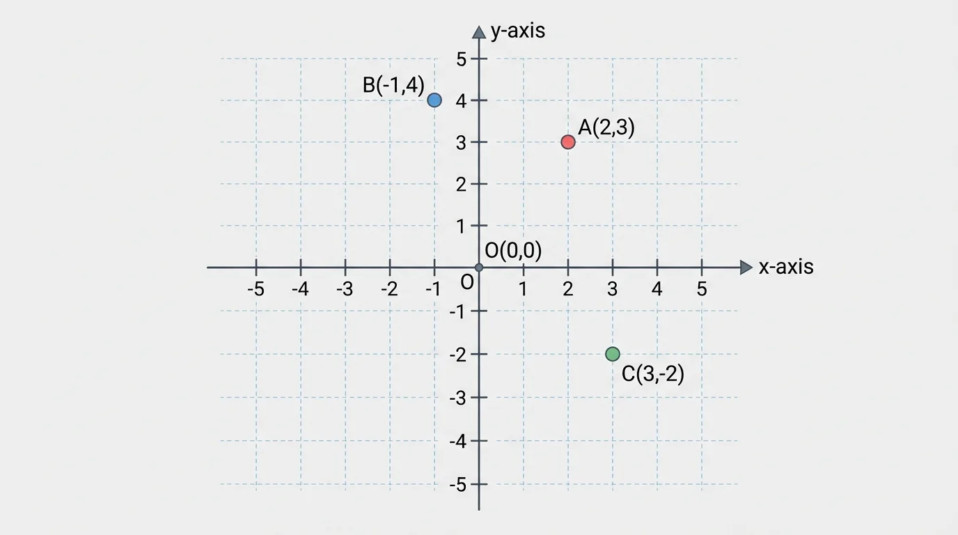
For example, to plot \( (4,3) \), move \(4\) units to the right and then \(3\) units up. To plot \( (-2,5) \), move \(-2\) units, which means \(2\) units left, and then \(5\) units up.
The order matters. The point \( (2,5) \) is not the same as \( (5,2) \). Switching the numbers changes the location of the point.
Vertex means a corner point of a polygon. The plural of vertex is vertices. In the coordinate plane, each vertex is written as an ordered pair.
Horizontal means going left and right. Vertical means going up and down.
These ideas matter because many coordinate-plane problems in geometry use polygons whose sides are horizontal or vertical. That makes the side lengths much easier to find.
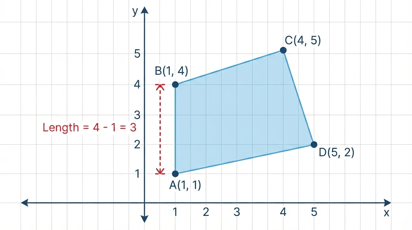
To draw a polygon from coordinates, plot each vertex carefully and connect the points in the given order. If the points are named \(A, B, C, D\), connect \(A\) to \(B\), then \(B\) to \(C\), then \(C\) to \(D\), and finally \(D\) back to \(A\).
As [Figure 2] illustrates, the order is important. If you connect the same points in a different order, you may create a different figure or cross lines that are not supposed to cross.
Suppose the vertices are \( (2,1), (2,4), (6,4), (6,1) \). Plot all four points. Then connect them in that order. Because two points share the same first coordinate and two points share the same second coordinate, the sides form a rectangle.
One good habit is to label each point after plotting it. Labels help you connect the vertices in the correct order and keep track of which side you are measuring.
How coordinate patterns reveal shape
If two points have the same first coordinate, they lie on a vertical line. If two points have the same second coordinate, they lie on a horizontal line. In rectangles and squares drawn on a coordinate plane, opposite sides often show these patterns clearly.
Later, when you find side lengths, those equal-coordinate patterns make the work much simpler than measuring slanted sides.
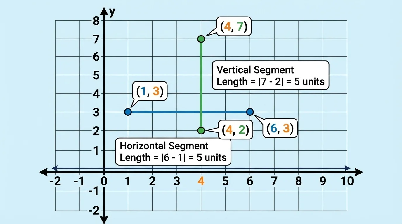
Some coordinate-plane side lengths are especially easy to find. A side is a horizontal side if the endpoints have the same second coordinate. A side is a vertical side if the endpoints have the same first coordinate.
As [Figure 3] shows, the points \( (1,3) \) and \( (6,3) \) have the same second coordinate, \(3\). So the segment joining them is horizontal.
The points \( (4,2) \) and \( (4,7) \) have the same first coordinate, \(4\). So the segment joining them is vertical.
These patterns are worth memorizing:
This is one of the most important ideas in the topic because it tells you immediately which coordinates to compare when finding the length.
When a segment is horizontal or vertical, you can find its length by counting grid units or subtracting the coordinate values.
For a horizontal segment, use the first coordinates. For a vertical segment, use the second coordinates.
If the segment joins \( (2,5) \) and \( (8,5) \), the length is the difference between the first coordinates:
\(8 - 2 = 6\)
So the segment is \(6\) units long.
If the segment joins \( (4,1) \) and \( (4,9) \), the length is the difference between the second coordinates:
\(9 - 1 = 8\)
So the segment is \(8\) units long.
Sometimes one coordinate is negative. Then subtraction still works.
For example, the length of the vertical segment from \( (3,-2) \) to \( (3,4) \) is
\[4 - (-2) = 6\]
So the side length is \(6\) units.
Negative coordinates let a coordinate plane describe locations on every side of the origin. That means one grid can model positions above, below, left, and right of a starting point.
It is often safest to subtract the smaller value from the larger value so the length is positive. Length is a distance, and distance is never negative.
Now let's use these skills to draw polygons and find lengths step by step.
Worked example 1
Draw the polygon with vertices \(A(1,2), B(1,5), C(6,5), D(6,2)\). Then find the length of each side.
Step 1: Plot the points.
Plot \(A(1,2)\), \(B(1,5)\), \(C(6,5)\), and \(D(6,2)\) on the coordinate plane.
Step 2: Connect the vertices in order.
Connect \(A\) to \(B\), \(B\) to \(C\), \(C\) to \(D\), and \(D\) to \(A\). The figure is a rectangle.
Step 3: Find \(AB\).
Points \(A(1,2)\) and \(B(1,5)\) have the same first coordinate, so \(AB\) is vertical. Its length is \(5 - 2 = 3\).
Step 4: Find \(BC\).
Points \(B(1,5)\) and \(C(6,5)\) have the same second coordinate, so \(BC\) is horizontal. Its length is \(6 - 1 = 5\).
Step 5: Use opposite sides.
\(CD = 3\) and \(DA = 5\) because opposite sides of a rectangle have equal lengths.
The side lengths are \(3, 5, 3, 5\).
This rectangle has a long side of \(5\) units and a short side of \(3\) units.
Worked example 2
Find the perimeter of the rectangle with vertices \( (2,1), (2,7), (9,7), (9,1) \).
Step 1: Find the height.
The vertical side goes from \(y = 1\) to \(y = 7\), so the height is \(7 - 1 = 6\).
Step 2: Find the width.
The horizontal side goes from \(x = 2\) to \(x = 9\), so the width is \(9 - 2 = 7\).
Step 3: Add all side lengths.
The perimeter is \(6 + 7 + 6 + 7 = 26\).
\[P = 26\textrm{ units}\]
Notice how the coordinates gave the side lengths directly. No ruler was needed.
Worked example 3
A rectangular playground is drawn on a coordinate grid with vertices \( (0,0), (0,8), (12,8), (12,0) \). Find its area.
Step 1: Find the side lengths.
The height is \(8 - 0 = 8\) units. The width is \(12 - 0 = 12\) units.
Step 2: Use the area formula for a rectangle.
\(A = l \times w\)
Step 3: Substitute the values.
\(A = 12 \times 8 = 96\)
\[A = 96\textrm{ square units}\]
This shows why coordinates are so useful in geometry: they help you draw the figure, find the lengths, and then calculate area.
Coordinates are used in designs for rooms, gardens, parks, and sports spaces. They show how a rectangular space can be described by its corner points. If the corners of a garden are known, you can find the side lengths and then determine fencing needed for the perimeter or grass needed for the area.
As [Figure 4] shows, suppose a community garden has corners at \( (3,2), (3,10), (11,10), (11,2) \). The vertical side length is \(10 - 2 = 8\) units, and the horizontal side length is \(11 - 3 = 8\) units. Because both side lengths are equal, the garden is a square.
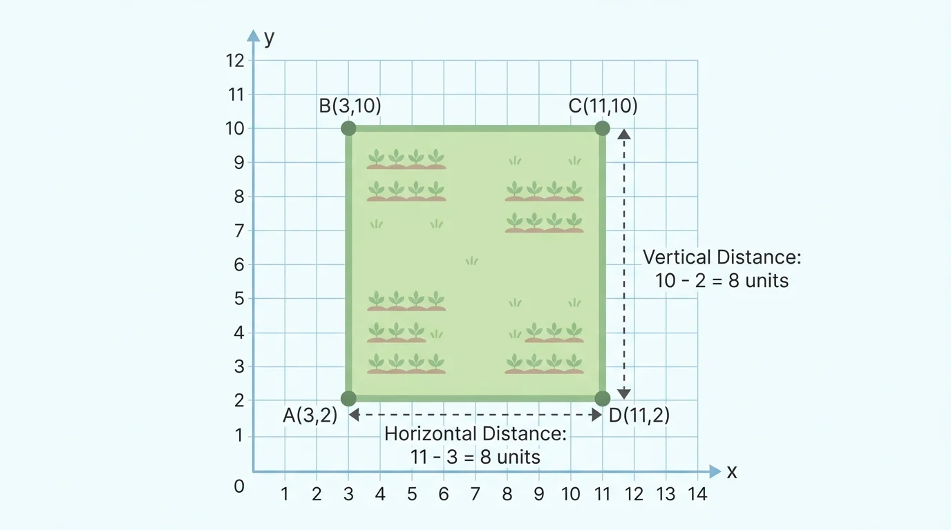
The perimeter is \(8 + 8 + 8 + 8 = 32\) units, and the area is \(8 \times 8 = 64\) square units.
Now consider a school mural planned on a wall. The corners are at \( (1,1), (1,4), (9,4), (9,1) \). The height is \(4 - 1 = 3\) units, and the width is \(9 - 1 = 8\) units. So the area is \(3 \times 8 = 24\) square units. If each square unit represents \(1\) square meter, then the mural covers \(24\) square meters.
As with the garden, knowing the coordinates of the corners lets you solve both drawing and measurement problems at the same time.
One common mistake is reversing the coordinates. Plotting \( (4,2) \) instead of \( (2,4) \) puts the point in a different place.
Another mistake is subtracting the wrong coordinates. If the side is horizontal, compare the first coordinates. If the side is vertical, compare the second coordinates.
A third mistake is forgetting to connect the last vertex back to the first one. A polygon must be closed.
| Situation | What to Check |
|---|---|
| Horizontal side | Same second coordinate; subtract first coordinates |
| Vertical side | Same first coordinate; subtract second coordinates |
| Drawing a polygon | Plot all vertices and connect them in the given order |
| Finding a length | Distance should be positive |
Table 1. Checks to use when drawing polygons and finding side lengths on the coordinate plane.
It also helps to ask whether the shape makes sense. If a figure is supposed to be a rectangle, opposite sides should have equal lengths and should be horizontal or vertical in matching pairs.
Many coordinate-plane problems in geometry are about rectangles and other polygons with horizontal and vertical sides. Once the side lengths are known, you can use formulas you already know.
For a rectangle with length \(l\) and width \(w\), the perimeter is
\(P = 2l + 2w\)
and the area is
\[A = l \times w\]
If a rectangle has vertices \( (-1,2), (-1,6), (4,6), (4,2) \), then the height is \(6 - 2 = 4\) units and the width is \(4 - (-1) = 5\) units.
So the perimeter is \(2(5) + 2(4) = 10 + 8 = 18\) units, and the area is \(5 \times 4 = 20\) square units.
"A graph is a picture of numbers, and numbers can tell a story about shape."
That story becomes especially clear when coordinates turn a set of points into a polygon you can measure and understand.