Video games, weather maps, and city maps all use location systems. A pilot may track a plane's position, a game designer may place objects on a grid, and a meteorologist may mark temperatures above and below zero. The same big idea connects all of these: a point can be located exactly when we use numbers in a careful order.
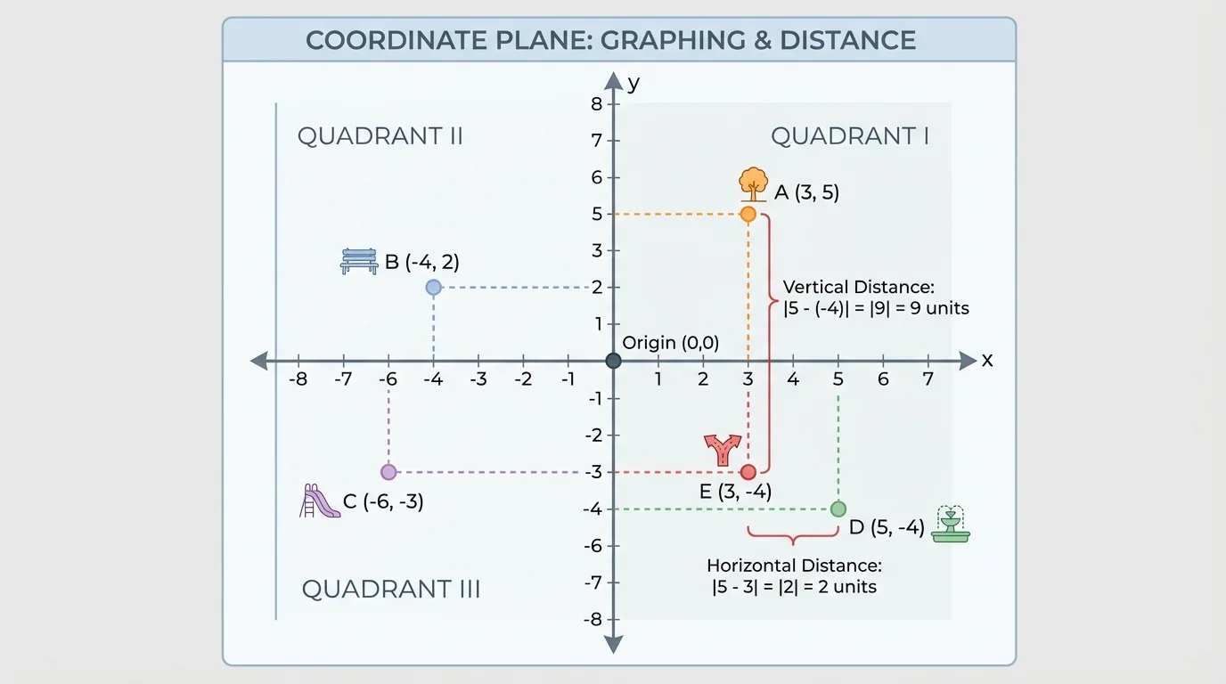
A coordinate plane is a flat grid formed by two number lines that cross at right angles, as [Figure 1] shows. The horizontal number line is called the x-axis, and the vertical number line is called the y-axis. The point where they meet is the origin, which has coordinates \(0,0\).
We name a point with an ordered pair. An ordered pair is written as \((x,y)\). The first number tells how far to move left or right from the origin. The second number tells how far to move up or down.
For example, to plot \((3,2)\), start at \((0,0)\). Move \(3\) units to the right because the first coordinate is positive \(3\). Then move \(2\) units up because the second coordinate is positive \(2\). That location is the point \((3,2)\).
If a point is \((-4,5)\), the first coordinate is negative, so move \(4\) units left. The second coordinate is positive, so move \(5\) units up. If a point is \((2,-3)\), move \(2\) units right and then \(3\) units down.
Coordinate plane: a grid formed by the \(x\)-axis and the \(y\)-axis.
Ordered pair: two numbers written in order, \((x,y)\), that name a point.
Origin: the point \((0,0)\), where the axes intersect.
Order matters. The point \((4,-2)\) is not the same as \((-2,4)\). Switching the numbers changes the location completely. One point may be to the right and down, while the other may be left and up.
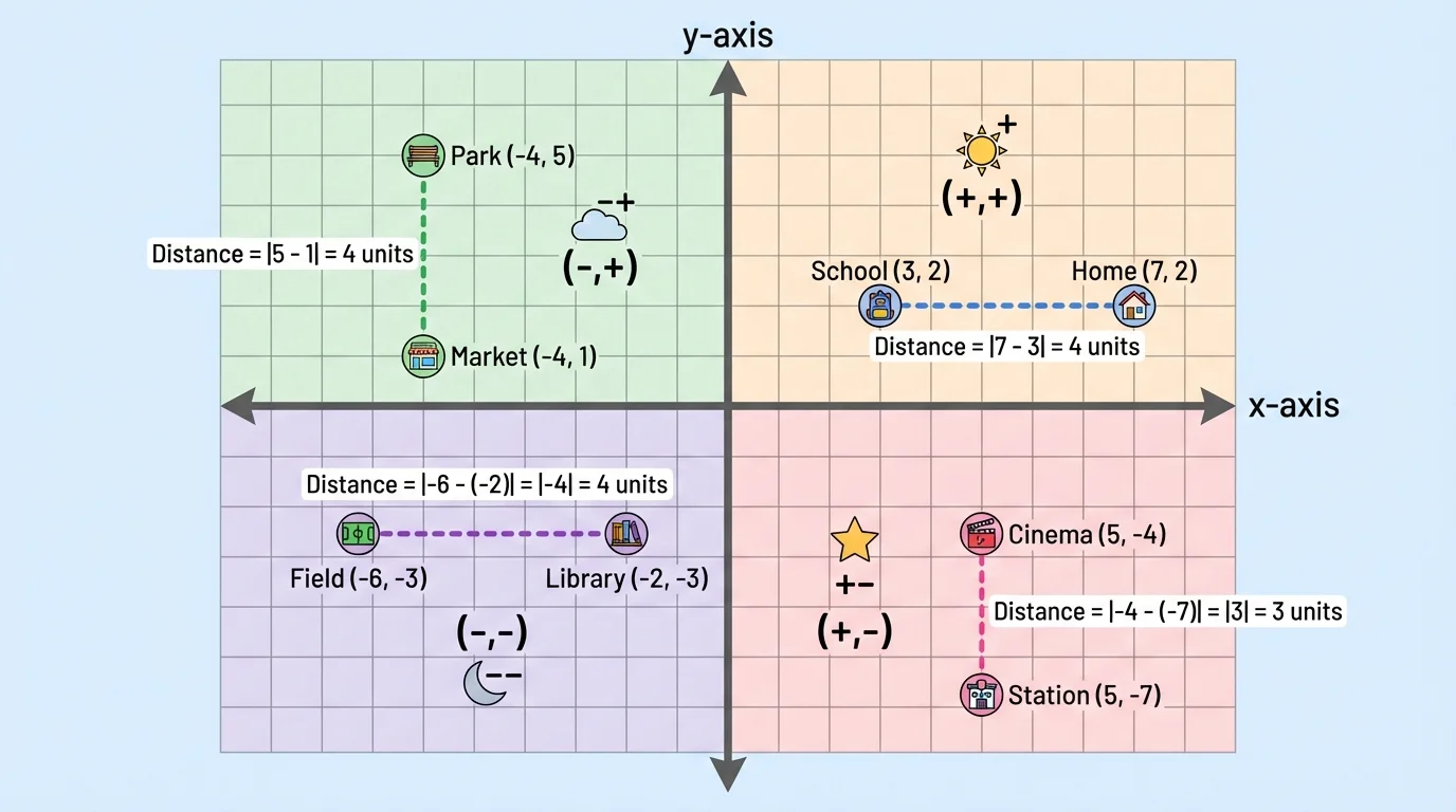
The axes divide the plane into four regions called quadrants. When you look at the signs of the coordinates, you can tell where a point belongs, as [Figure 2] illustrates. This is especially helpful when points have negative coordinates.
The quadrants are named using Roman numerals and are counted counterclockwise, starting in the upper-right region.
Here is the sign pattern for each quadrant:
| Quadrant | Signs of Coordinates | Example Point |
|---|---|---|
| I | \((+, +)\) | \((2,3)\) |
| II | \((-, +)\) | \((-2,3)\) |
| III | \((-, -)\) | \((-2,-3)\) |
| IV | \((+, -)\) | \((2,-3)\) |
Table 1. The four quadrants and the sign patterns of coordinates in each one.
If a point lies on an axis, it is not in any quadrant. For example, \((0,4)\) lies on the \(y\)-axis because its first coordinate is \(0\). The point \((-6,0)\) lies on the \(x\)-axis because its second coordinate is \(0\).
Negative numbers are less than \(0\). On a number line, numbers get smaller as you move left and larger as you move right. The coordinate plane uses that same idea in two directions.
A quick way to remember the quadrants is to think about directions from the origin: right means positive \(x\), left means negative \(x\), up means positive \(y\), and down means negative \(y\). The sign patterns in [Figure 2] come directly from those movements.
When you read a graphed point, always write the horizontal value first and the vertical value second. This means: read \(x\) first, then \(y\).
Suppose a point is \(5\) units left of the origin and \(1\) unit down. Its coordinates are \((-5,-1)\). A common mistake is writing \((-1,-5)\), but that would describe a different point.
Why the order matters
You can think of an ordered pair as directions. The first number gives the horizontal move, and the second number gives the vertical move. If you reverse the order, you follow different directions and land at a different location.
You can also compare points. If two points have the same first coordinate, they line up vertically because they are on the same vertical line. If two points have the same second coordinate, they line up horizontally because they are on the same horizontal line.
For example, the points \((2,4)\) and \((2,-1)\) have the same first coordinate, \(2\). So they are on the same vertical line. The points \((-3,5)\) and \((4,5)\) have the same second coordinate, \(5\). So they are on the same horizontal line.
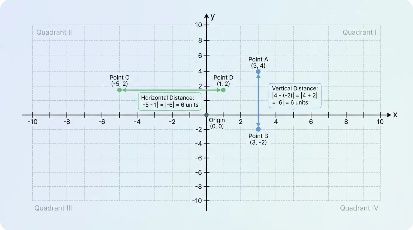
[Figure 3] Sometimes we want more than just location. We also want to know how far apart two points are. In Grade \(6\), the main distances you find on the coordinate plane are horizontal distance and vertical distance. These happen when two points share the same \(x\)-coordinate or the same \(y\)-coordinate.
If two points have the same first coordinate, they are directly above and below each other. Their distance is the difference between the second coordinates. If two points have the same second coordinate, they are directly side by side. Their distance is the difference between the first coordinates.
To make sure distance is never negative, we use absolute value. Absolute value tells how far a number is from \(0\) on a number line. For example, \(|-4| = 4\) and \(|4| = 4\).
The formulas are simple:
If points have the same \(x\)-coordinate, then the vertical distance is
\(|y_2 - y_1|\)
If points have the same \(y\)-coordinate, then the horizontal distance is
\(|x_2 - x_1|\)
These formulas work even when one or both coordinates are negative. That is one reason absolute value is so useful. For instance, the distance between \(-2\) and \(5\) on a number line is not \(-7\). It is \(|5-(-2)| = |7| = 7\).
Maps and navigation systems often use coordinate ideas behind the scenes. Even when you do not see a full graph, digital tools still track positions using numbers that describe left-right and up-down movement.
You can also think of horizontal and vertical distance as counting grid units between points. But when coordinates are larger or include negative numbers, the absolute value formulas are faster and more reliable than counting one square at a time.
Let us work through several examples carefully.
Example 1: Plotting and naming a point
Plot the point \((-3,4)\) and name its quadrant.
Step 1: Read the first coordinate.
The first coordinate is \(-3\), so move \(3\) units left from the origin.
Step 2: Read the second coordinate.
The second coordinate is \(4\), so move \(4\) units up.
Step 3: Identify the quadrant.
The point has signs \((-,+)\), so it is in Quadrant II.
The point \((-3,4)\) is in Quadrant II.
Notice that a negative first coordinate moves the point left, while a positive second coordinate moves it up. That sign pattern matches Quadrant II from [Figure 2].
Example 2: Finding a vertical distance
Find the distance between \((2,5)\) and \((2,-3)\).
Step 1: Check what coordinate is the same.
Both points have first coordinate \(2\), so the distance is vertical.
Step 2: Use the second coordinates.
Compute \(|5-(-3)|\).
Step 3: Simplify.
\(|5-(-3)| = |8| = 8\)
The vertical distance is \(8\).
This means the points are \(8\) units apart. You can see why the answer is positive: distance measures how far apart points are, not direction.
Example 3: Finding a horizontal distance
Find the distance between \((-6,1)\) and \((4,1)\).
Step 1: Check what coordinate is the same.
Both points have second coordinate \(1\), so the distance is horizontal.
Step 2: Use the first coordinates.
Compute \(|4-(-6)|\).
Step 3: Simplify.
\(|4-(-6)| = |10| = 10\)
The horizontal distance is \(10\).
This example crosses the \(y\)-axis. A point can be on one side of the axis and another point on the other side, but the absolute value still gives the correct distance.
Example 4: Solving a real-world problem
On a city map, a library is at \((-2,3)\) and a school is at \((-2,-4)\). How many blocks apart are they if each grid unit is \(1\) block?
Step 1: Check whether the points line up vertically or horizontally.
Both points have first coordinate \(-2\), so they line up vertically.
Step 2: Find the distance.
Compute \(|3-(-4)| = |7| = 7\).
Step 3: Interpret the answer.
Since each unit is \(1\) block, the locations are \(7\) blocks apart.
The library and school are 7 blocks apart.
When a city is laid out in streets and avenues on a grid, you can use coordinates to describe where each place is and use horizontal or vertical distance to find how far apart places are when they are on the same street or avenue.
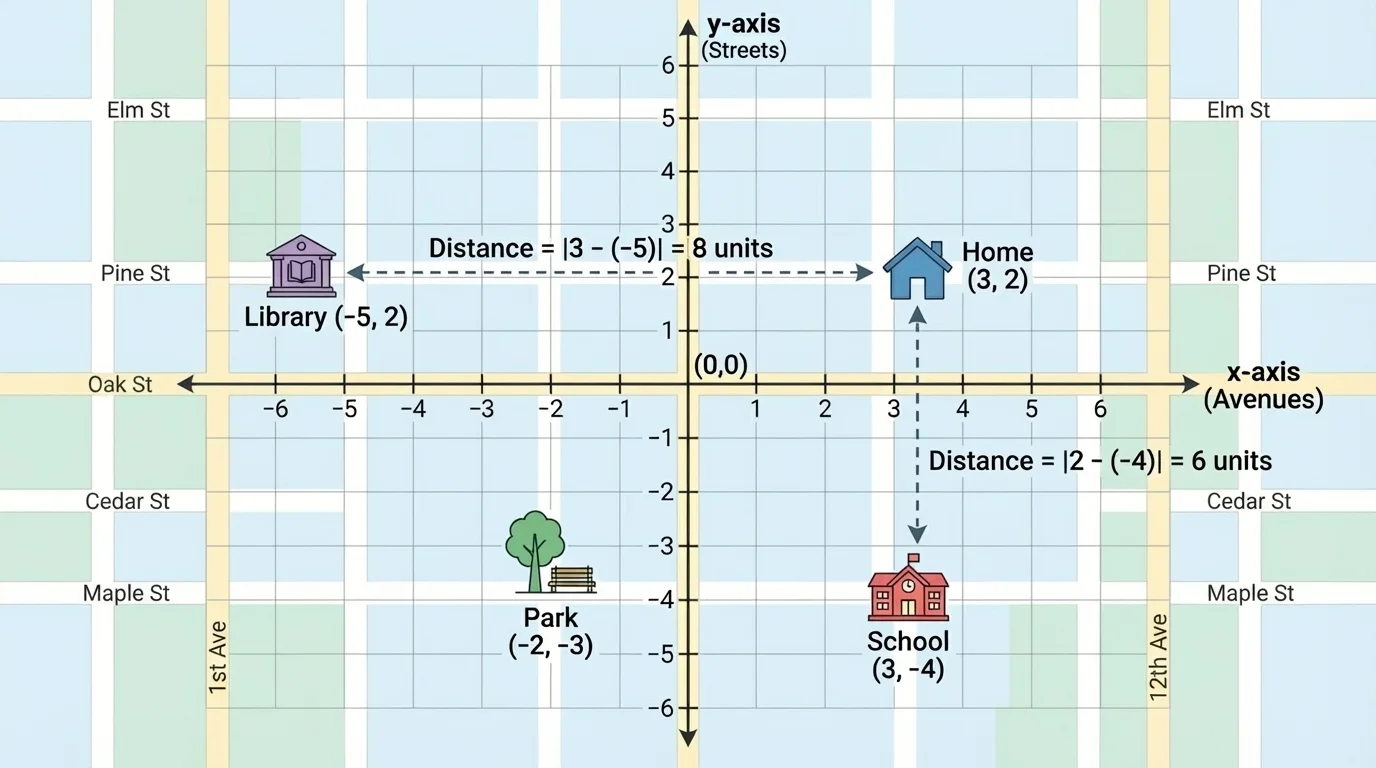
[Figure 4] Suppose a park is at \((4,-1)\) and a bus stop is at \((-3,-1)\). They have the same second coordinate, so they are on the same horizontal line. Their distance is \(|4-(-3)| = 7\). If each unit represents \(100\) meters, then the park and bus stop are \(700\) meters apart.
Coordinate planes are also useful in games. A treasure chest might be at \((5,2)\), while a player stands at \((5,-1)\). Because the first coordinates match, the player needs to move straight up. The vertical distance is \(|2-(-1)| = 3\), so the player is \(3\) units from the treasure chest.
Scientists and meteorologists often use graphs with positive and negative values. A temperature change can go above or below zero, and elevation can be above or below sea level. The coordinate plane helps organize these values so patterns are easy to see.
How absolute value helps in real problems
When coordinates include negative numbers, subtraction can be tricky. Absolute value keeps the answer focused on distance, not direction. That is why \(|y_2-y_1|\) and \(|x_2-x_1|\) are so important in coordinate problems.
When using a grid in the real world, it is important to know what each unit means. One unit might stand for \(1\) block, \(10\) feet, \(1\) mile, or another measure. The coordinate method stays the same, but the meaning of the answer depends on the scale.
One common mistake is forgetting the order of coordinates. Always write \((x,y)\), not \((y,x)\). Another common mistake is saying a point on an axis is in a quadrant. Points on the axes are not in any quadrant.
A third mistake happens when finding distance. Students sometimes subtract and stop with a negative answer. For example, with \((1,-2)\) and \((1,4)\), a student might write \(-2-4=-6\). But distance cannot be negative. The correct calculation is \(|-2-4| = |-6| = 6\).
It also helps to check whether the points actually have the same first coordinate or same second coordinate. If they do not, then the horizontal-or-vertical distance formula does not apply directly. In this lesson, we focus on points that line up horizontally or vertically.
The coordinate plane from [Figure 1] and the horizontal and vertical segments from [Figure 3] together show the main idea: coordinates tell location, and absolute value helps find distance when points are on the same vertical or horizontal line.