Have you ever seen a map on the weather report and then looked at a map on a phone or in a car? They are both maps, but they do not do the same job. One map may help people know if rain is coming. Another map may help people find the way to a park or school. Maps are like tools in a toolbox. You pick the right tool for the right job.
A map is a representation of a place. A map can show a whole world, one country, one town, or even one classroom. But every map has a purpose. A map's purpose is the reason it was made. When we identify a map's purpose, we are answering the question, What information is this map trying to give me?
Purpose means the job something is made to do. A map's purpose tells what the map helps us learn, such as where roads are, where rain is falling, or where mountains are located.
Some maps help us find places. Some maps help us learn about weather. Some maps help us see land and water. Others help us understand borders, like the lines between states or countries. If we know the purpose, we know how to read the map better.
Think of it this way: if you want to know whether to wear boots, a weather map is helpful. If you want to walk from your house to the library, a street map is helpful. Both maps are useful, but each one gives a different kind of information.
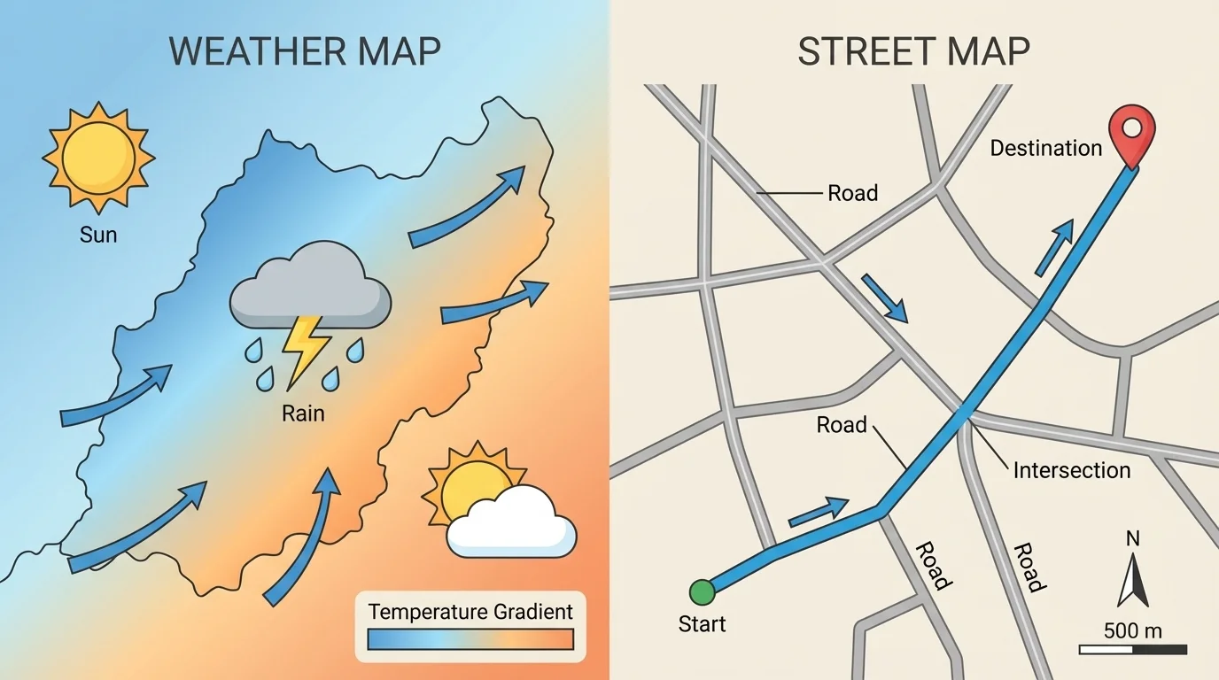
We can figure out a map's purpose by looking for clues. As [Figure 1] shows, a weather map and a street map use very different symbols and colors because they answer different questions. Good map readers look carefully before they decide what the map is for.
One important clue is the title. The title may say something like Weather Map of the United States or Downtown Street Map. Another clue is the legend, also called a key. The legend explains what symbols mean. A cloud symbol may mean rain. A thick line may mean a highway. Colors are clues too. Blue areas may show water. Green and brown may show land. Red or yellow may show warm weather or important roads.
Labels also help. If the map labels streets with names such as Pine Street or Oak Avenue, it is probably a street map. If the map labels storms, sun, clouds, temperatures, or fronts, it is probably a weather map. We can also notice what is missing. A weather map usually does not need every small road. A street map usually does not need cloud symbols across the whole state.
Map symbols are like a picture language. A small airplane symbol might show an airport. A blue line might show a river. A star might show a capital city. These symbols are chosen to match the map's purpose. If you see many road lines, street names, and route markers, the map is helping you travel. If you see weather symbols, the map is helping you know what is happening in the sky.
One place can be shown on many different maps. Your town might appear on a road map, a weather map, a landform map, and even a map of where schools are located.
When you look at maps, ask yourself a few simple questions. What does the title say? What do the symbols show? What do the colors mean? What kind of labels are on the map? These questions help you discover the purpose.
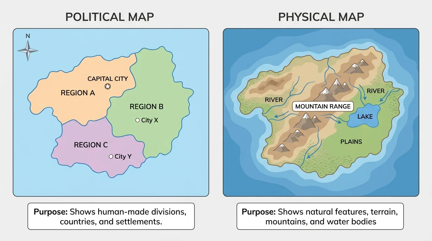
There are many kinds of maps, and each kind is made for a special reason. The same place can be shown in more than one way, as [Figure 2] illustrates with one map focusing on borders and names while another focuses on land and water features.
A weather map shows what the weather is like in different places. It may show sun, clouds, rain, snow, wind, or warm and cold areas. People use weather maps to plan what to wear or whether it is safe to travel.
A street map shows roads, streets, bridges, and sometimes buildings or parks. People use street maps to get from one place to another. A street map helps answer questions like, "How do I get to the zoo?" or "Which road leads to the hospital?"
A political map shows places such as countries, states, and cities. It often has boundary lines. This map helps people locate places and understand where one area ends and another begins.
A physical map shows natural features of Earth, such as mountains, rivers, lakes, and deserts. It helps people learn about the land itself.
Some maps are very small in area, like a map of a school. A school map may show classrooms, the office, the cafeteria, and the playground. Its purpose is to help people find places inside the school area. Even though it is smaller than a map of a state, it still has a purpose.
Later, if you compare maps again, you can look back at [Figure 1]. The weather map uses symbols for weather conditions, while the street map uses lines and names to help with travel. Looking for that difference is a smart way to identify purpose.
Good map readers do not just look at maps. They choose the best map for the question they want to answer. If the question is, "Will it rain today?" a weather map is the best choice. If the question is, "Which way do I turn to get to the library?" a street map is the best choice.
Choosing the right map
Step 1: Read the question.
Question: "Where is the river?"
Step 2: Think about what kind of information is needed.
The question is about a natural feature, not streets or weather.
Step 3: Pick the best map.
A physical map is a good choice because it shows rivers, mountains, and lakes.
The best map is the one that matches the information you need.
Here are more examples. To learn where a storm is moving, use a weather map. To find your route to a friend's house, use a street map. To locate Nebraska or Texas, use a political map. To find a mountain range, use a physical map. The purpose of the map should match the job you are trying to do.
Sometimes two maps can help with one trip. A family might first check a weather map to see if snow is coming. Then they might use a street map or road map to choose the best route. The maps work together, but each one has its own purpose.
| Question | Best Map | Why |
|---|---|---|
| Will it be sunny or rainy? | Weather map | It shows weather conditions. |
| How do I get to the park? | Street map | It shows roads and routes. |
| Where is our state? | Political map | It shows states and borders. |
| Where are mountains and rivers? | Physical map | It shows natural land features. |
Table 1. Examples of matching questions to the best type of map.
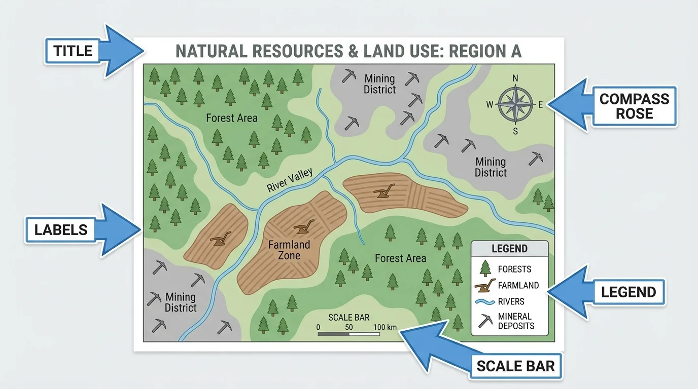
Map parts help readers understand what the map is for. Even when maps have different purposes, many of them use some of the same tools.
As [Figure 3] shows, a compass rose shows directions such as north, south, east, and west. This helps us know where places are located. A scale shows distance. It helps us understand how far apart places are. Labels tell the names of places. A legend explains symbols. The title tells what the map is about.
Not every map uses the same features in the same way. A street map may have many labels and route lines because people need details for travel. A weather map may have fewer street names but more weather symbols, colors, and temperature areas. A physical map may use color to show high land and low land. These choices all connect to purpose.
Map features and purpose
A map maker chooses features based on the map's job. If the purpose is travel, roads and street names matter most. If the purpose is weather, symbols for rain, snow, wind, and temperature matter most. If the purpose is showing landforms, mountains, rivers, and elevation colors matter most.
If you forget what a map is for, go back to the map features. Read the title. Check the legend. Notice the symbols. Look at the labels. These features are clues that help you identify the purpose correctly.
When you later study another map, [Figure 3] can still help because it reminds you where to look first: title, legend, compass rose, and scale. Those parts guide your eyes to the map's meaning.
Maps are used every day by many people. Drivers use street and road maps. Pilots use maps for travel routes. Meteorologists, who study weather, use weather maps. Hikers use maps to understand trails and landforms. Firefighters and other helpers may use maps to find places quickly during emergencies.
Maps also help in school and at home. A student may use a classroom map to find the library. A family may use a city map to visit a museum. People going on vacation may look at a weather map, a road map, and a state map. Each map helps with a different part of the trip.
Earlier map lessons may have taught that maps show location and direction. That is still true here. Now the big new idea is that different maps show different kinds of information because they have different purposes.
Maps help people make decisions. If a weather map shows snow, people may stay home or drive carefully. If a street map shows a bridge and nearby roads, people can plan the fastest path. If a physical map shows a river, people can understand where water flows through the land.
This is an important idea in geography: one place can be described in many ways. A city can appear on a weather map, a street map, and a political map. The city does not change, but the information shown on the map changes.
For example, a map of Florida on the weather report may show clouds, sun, and storms. A street map of a Florida city may show roads, bridges, and neighborhoods. A political map may show Florida as one state in the United States. A physical map may show beaches, lakes, and low land. These are all about the same place, but each map has a different purpose.
That is why good readers never say only, "It is a map." They ask, "What kind of map is it?" and "What does it help me know?" Those questions lead to the map's purpose.
Case study: one town, many maps
A class studies one town near a river.
Step 1: The class looks at a weather map.
They learn that rain is moving toward the town.
Step 2: The class looks at a street map.
They find the roads, bridge, school, and park.
Step 3: The class looks at a physical map.
They see the river and nearby hills.
Step 4: The class looks at a political map.
They locate the town in its state and country.
Each map teaches something different about the same town.
When you identify the purpose of a map, you become a stronger geography learner. You can locate places, describe them, and understand what information the map maker wants you to notice most.