Have you ever driven for a while and noticed that the land suddenly looks different? Flat grassland can change into steep mountains. A busy city can turn into a quiet farming area. That happens because places are part of different regions. A region is an area that has features in common, and geographers use regions to help us understand how places are alike and different.
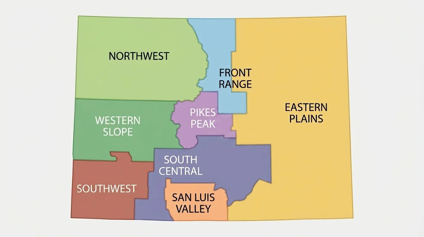
A region is a place that is grouped together because it shares important traits. Those traits might be natural, such as mountains or rivers, or they might come from people, such as towns, roads, jobs, and traditions. When geographers study Colorado, they often divide it into regions with shared features, as shown in [Figure 1]. This helps us look carefully at land, communities, and ways of life.
A region does not have to be exactly the same everywhere inside it. The places in a region simply share enough features that we can study them together. For example, the Front Range has large cities and mountain views, while the Eastern Plains are more open and flat. Both are in Colorado, but they feel very different.
Regions help answer questions like these: Why do many people live in one area but not another? Why are some places better for farming, skiing, or ranching? Why do buildings, roads, and jobs change from place to place? A region gives us a useful way to organize those answers.
Physical characteristics are natural features of a place, such as mountains, rivers, soil, and weather.
Cultural characteristics are ways people live, including language, traditions, food, celebrations, and history.
Human-made characteristics are things people build or change, such as roads, farms, neighborhoods, bridges, and dams.
When we describe a region well, we usually look at all three kinds of characteristics. That gives us a fuller picture of what a place is really like.
First, we can observe a region's physical characteristics. We ask: Is the land flat, hilly, or mountainous? Is the climate dry, snowy, windy, or warm? Are there rivers, forests, deserts, or valleys? These natural features shape how people use the land.
Second, we can observe its cultural characteristics. We ask: What traditions are important here? What foods or music are common? What groups of people have lived here for a long time? What festivals or community events happen here? Culture helps make each region special.
Third, we can observe its human-made characteristics. We ask: What kinds of homes, roads, farms, stores, schools, and parks are here? Are there railroads, ski lifts, highways, or tall office buildings? These clues show how people have shaped the place.
Colorado has very different regions packed into one state. In one trip, a person can see plains, high mountains, deep valleys, forests, canyons, and deserts.
Putting these three kinds of observations together helps us describe a place clearly instead of using only one detail. A region is more than just land. It is also a home for communities and a place where people build, work, and celebrate.
Colorado is often divided into several local regions: the Eastern Plains, San Luis Valley, Pikes Peak, Northwest, Front Range, South Central, Southwest, and Western Slope. Each one has its own pattern of landforms, communities, and activities.
The Eastern Plains are known for wide, open spaces and flatter land. The San Luis Valley is a large high valley surrounded by mountains. The Pikes Peak region includes mountain landscapes and nearby communities centered on the famous mountain. The Northwest has mountains, forests, and river valleys. The Front Range includes many of Colorado's largest cities along the edge of the Rocky Mountains.
The South Central region includes mountain areas, valleys, and small towns. The Southwest includes mesas, canyons, mountains, and places with strong Indigenous and Hispanic history. The Western Slope lies west of the Continental Divide and includes plateaus, orchards, canyons, and river areas.
These regions are not random. They are based on important similarities and differences in the land and in communities. That is why the idea of region is such a helpful geography tool.
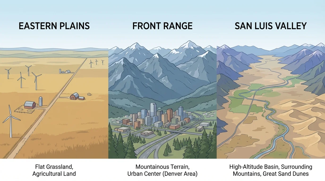
Natural features often stand out first when we study a place, and [Figure 2] illustrates how different Colorado landscapes can be. Physical characteristics include landforms, bodies of water, weather, plants, and animals. These features help shape how people travel, live, and work.
The Eastern Plains have broad, flatter land. Grasses grow well there, and much of the area is used for farming and ranching. The Front Range includes foothills and mountains near cities such as Denver, Boulder, and Colorado Springs. The San Luis Valley is a wide valley with mountains around it. The Western Slope includes canyons, mesas, and river valleys. In the Northwest and Southwest, mountains and forests are common.
Water is another important physical feature. Some regions have important rivers and streams that support farms, towns, and wildlife. Snow in the mountains melts and becomes water for other places. Valleys and river areas can be good for farming because of water and soil.
Climate also matters. Higher places are often cooler and snowier. Some lower regions are drier. The San Luis Valley is famous for being high and dry, with cold winters and sunny days. The Eastern Plains can be windy, while mountain regions may have heavy snow. These differences affect what people wear, what crops they grow, and how they travel.
Plants and animals are part of physical geography too. On the plains, you may see grasslands and animals adapted to open spaces. In mountain regions, there may be pine forests, elk, and black bears. In drier parts of the Western Slope and Southwest, you may see shrubs and rocky landscapes.
How land shapes life
Physical characteristics do not only describe nature. They also help explain human choices. Flat land can make it easier to build roads and farms. Steep mountains can make travel harder but may attract visitors for hiking and skiing. Valleys may offer space for towns, fields, and rivers.
Later, when we compare communities, we can return to [Figure 2] and see that the shape of the land helps explain why homes, jobs, and transportation differ from one region to another.
A region is not only about nature. People bring stories, traditions, languages, food, music, and celebrations. These are cultural characteristics, and they grow over time as families and communities live in a place.
Colorado's regions include the history of Indigenous peoples such as the Ute, Arapaho, Cheyenne, and many others connected to this land. Their knowledge, traditions, and relationships with the land are an important part of regional culture. Later, Hispanic communities, miners, ranchers, farmers, railroad workers, and many other groups shaped different parts of the state.
In the San Luis Valley and Southwest, many communities have deep Hispanic roots, seen in architecture, festivals, food, family history, and place names. In mountain communities, tourism and outdoor life can shape local traditions. On the Eastern Plains, agricultural life often influences fairs, rodeos, and harvest events. In the Front Range, many cultures come together in larger cities, creating a mix of languages, arts, restaurants, and celebrations.
Cultural characteristics can also include what people value. Some communities may be strongly connected to farming. Others may focus on outdoor recreation, arts, science, or business. Even schools, museums, and local events can reflect a region's culture.
"Places help shape people, and people help shape places."
Culture changes over time, but it also keeps important traditions alive. When we observe murals, festivals, local foods, historic buildings, and community gatherings, we learn more about the identity of a region.
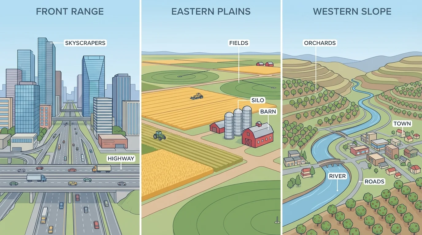
[Figure 3] helps show how people change places by building and using the land in different ways. Human-made characteristics include roads, railroads, farms, dams, neighborhoods, ski resorts, stores, parks, and schools.
The Front Range has many large highways, neighborhoods, office buildings, stadiums, and shopping areas because many people live there. The Eastern Plains have more farms, grain storage structures, long roads, and smaller towns spread farther apart. Mountain regions may have winding roads, tunnels, ski lifts, and cabins. The Western Slope may include orchards, vineyards, irrigation systems, and towns along rivers.
Human-made features often match the physical landscape. Flat land can support long straight roads and large fields. Mountain regions may need bridges, switchback roads, or tunnels. River valleys may have dams or canals to move water where it is needed.
Jobs are connected to human-made features too. In one region, many people may work in farming or ranching. In another, tourism, health care, technology, or education may be more common. The built environment gives us clues about the kinds of work people do there.
When we think back to [Figure 3], we can see that roads, homes, and farms are not placed the same way everywhere. People build what fits the land, climate, and community needs.
One of the most important geography skills is comparing places. To compare regions, we look for similarities and differences. Similarities tell us why certain places belong in the same group. Differences help us understand what makes each region unique.
For example, both the Front Range and the Pikes Peak region have mountain views and growing communities. But the Front Range includes a long urban corridor with very large cities, while the Pikes Peak region is centered more closely around one famous mountain and nearby communities.
The Eastern Plains and San Luis Valley both have farming, but their landforms are different. The Eastern Plains are flatter and more open. The San Luis Valley is a high basin surrounded by mountains. That difference affects climate, scenery, and transportation.
| Region | Physical clues | Cultural clues | Human-made clues |
|---|---|---|---|
| Eastern Plains | Flat grasslands, open sky | Farm fairs, ranching traditions | Fields, silos, small towns, long roads |
| Front Range | Foothills near mountains | Many cultures, city events | Highways, neighborhoods, tall buildings |
| San Luis Valley | High valley, dry climate, mountain edges | Deep Hispanic history, farming communities | Irrigation, small towns, farm fields |
| Western Slope | Canyons, mesas, river valleys | Orchard and outdoor traditions | Orchards, vineyards, river towns |
Table 1. Examples of physical, cultural, and human-made clues in four Colorado regions.
Comparing regions helps us move beyond simple labels. Instead of saying one place is "country" and another is "city," we can describe exactly what we observe and explain why those differences matter.
Case study: describing the Eastern Plains
Step 1: Notice the physical characteristics.
The land is flatter, with wide grasslands and fewer mountains.
Step 2: Notice the cultural characteristics.
Many communities connect to farming, ranching, fairs, and rodeos.
Step 3: Notice the human-made characteristics.
You may see fields, fences, grain elevators, farm roads, and small towns.
A clear description might be: The Eastern Plains is a region of open grassland, farming communities, and human-made features that support agriculture.
Strong geography descriptions use evidence. That means we support our ideas with real observations, not guesses.
Geographers look carefully, ask questions, and use evidence from maps, photographs, and direct observation. They pay attention to land, climate, resources, community life, and buildings.
A good description often starts with location. For example, a person might say that the Western Slope is west of the Rocky Mountains, or that the Front Range lies along the eastern edge of the mountains. Then the description adds details about physical, cultural, and human-made characteristics.
Words such as flat, steep, dry, busy, rural, urban, historic, and agricultural can help. The best words are the ones that match what we truly observe.
When you use a map, remember to look for titles, labels, symbols, and where places are located. Maps help explain where a region is and how it connects to other regions.
It also helps to ask why a region developed in a certain way. Why are there orchards on part of the Western Slope? Why are there so many large cities in the Front Range? Why do some regions have smaller towns? Geography becomes more interesting when we connect what we see to reasons.
These two regions can be compared trait by trait, and [Figure 4] displays how one careful comparison can organize our thinking. Both regions are in Colorado, but they feel very different because of landforms, climate, population, and land use.
The Front Range includes many of the state's biggest cities. It has foothills, mountain views, busy highways, schools, businesses, and neighborhoods. It is home to many jobs in government, technology, medicine, education, and trade. Because many people live there, the region has many human-made features.
The San Luis Valley has a broad open valley surrounded by mountain ranges. It has a drier climate and many agricultural areas. Communities there may be smaller and more spread out. Farming, ranching, and local history are important parts of life.
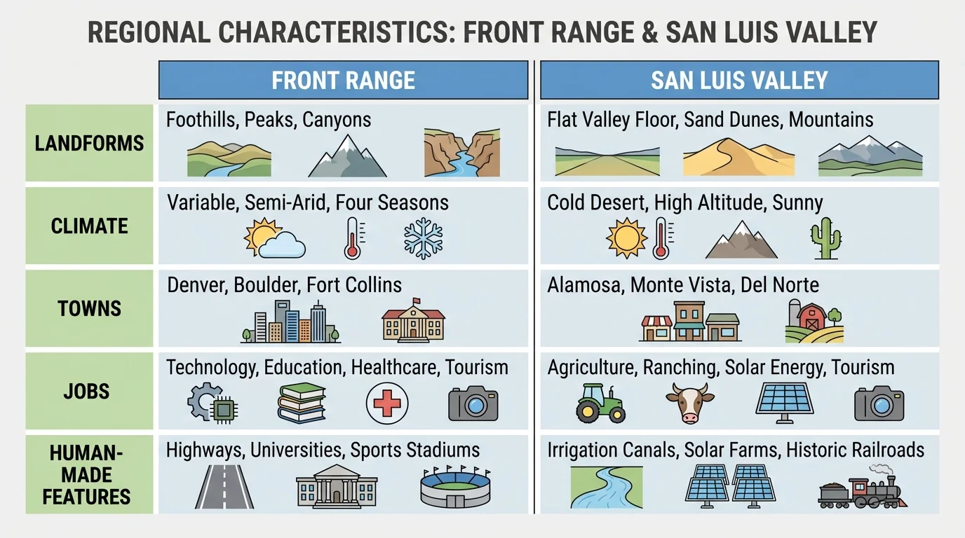
Culturally, both regions have strong communities, but their histories and daily experiences differ. The Front Range has a larger urban population and many newcomers from different places. The San Luis Valley has long-standing community traditions and deep historical roots.
If we return to [Figure 4], we can clearly see that one region is more urban and crowded, while the other is more rural and open. Neither is better; they simply have different regional characteristics.
Case study: comparing two regions
Step 1: Compare the land.
The Front Range has foothills and cities near mountains. The San Luis Valley has a wide high valley surrounded by mountains.
Step 2: Compare the communities.
The Front Range has many large cities. The San Luis Valley has smaller towns and farming communities.
Step 3: Compare what people build and do.
The Front Range has major highways and many businesses. The San Luis Valley has irrigation systems, farms, and open land.
This comparison shows how regions can be different in several connected ways at the same time.
That is an important idea in geography: land, culture, and human activity work together. A region is easier to understand when we notice those connections.
Regions matter because they help explain everyday life. They affect where homes are built, which jobs are common, what food is grown, where roads go, and what recreation people enjoy. A mountain region may support skiing and hiking. A plains region may support wheat farming and ranching. A valley may support both farming and close community ties.
Regions also help people make decisions. City leaders, farmers, engineers, teachers, and families all need to understand the place where they live. If an area is dry, water planning matters. If an area gets heavy snow, roads and buildings must be designed for that weather. If an area is growing quickly, schools and transportation may need to expand.
Learning about regions also builds respect. When we understand that communities develop in different kinds of places, we can appreciate their unique strengths, traditions, and challenges. The open Eastern Plains, the busy Front Range, the historic San Luis Valley, the rugged Southwest, and the fruit-growing Western Slope all add something important to Colorado.
Observing a local region means looking closely, using evidence, and describing what makes that place special. The more carefully we notice physical, cultural, and human-made characteristics, the better we understand how places and communities are connected.