Why do some places have snowy mountains, some have busy streets full of buses, and some have wide farms with fields stretching far away? Geographers study these patterns to understand the world. They often group places into regions. A region is an area that has something in common. The common feature might be the land, the weather, the people, the language, the government, or the way people live.
A region is a place or area that is grouped together because it shares certain features. These features help us understand how places are similar and how they are different. A region does not always have one exact shape. Sometimes it has clear borders, and sometimes it does not.
Region means an area that is grouped together because it has shared features. These features can be natural, such as mountains or rivers, or human, such as language, borders, or ways of life.
For example, a desert region may have dry land, little rain, and special plants that can live with very little water. A city region may have many buildings, roads, stores, and people living close together. A farming region may have lots of open land, fields, and barns. These places are all regions because they share traits.
Geographers compare similarities and differences. Similarities are ways places are alike. Differences are ways places are not alike. If two communities both have cold winters and many pine trees, they may belong to the same physical region. If one community has skyscrapers and subways while another has cornfields and gravel roads, they are different in important ways.
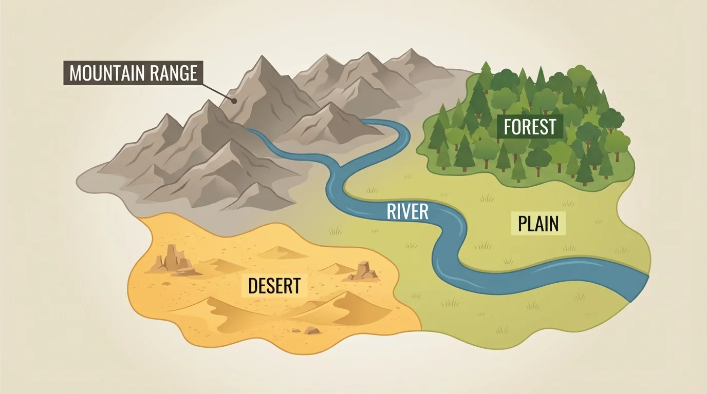
The first kind of clue geographers use is nature. A physical feature is a natural part of Earth, such as mountains, hills, rivers, lakes, plains, deserts, and forests. These features often help us recognize a region, as [Figure 1] shows with different land and water patterns in one larger area.
Physical regions can also be described by climate. Climate means the usual weather of a place over a long time. Some regions are hot and dry. Some are cold and snowy. Some are warm and rainy. Climate affects the plants, animals, and jobs people can have in a region.
Think about a mountain region. It may have high land, cooler temperatures, rocky slopes, and fast-moving streams. A plain region is flatter and may be good for farming. A coastal region lies near an ocean or sea and may have beaches, harbors, and milder weather. A river valley region often has rich soil that helps crops grow.
Physical features affect how people live. In a region with many rivers, people may fish, travel by boat, or build towns near the water. In a cold northern region, homes may need strong heat in winter. In dry regions, farmers may need irrigation, which means bringing water to crops.
Different physical regions can be found all over the world. The Amazon Rainforest region in South America is warm, wet, and filled with thick trees. The Sahara Desert region in Africa is dry and sandy. The Great Plains region in the United States has wide grasslands and open space. Even though all of these are regions, they look very different because their physical features are different.
Some rivers help create regions because people settle near them for water, travel, and farming. Long ago and today, many cities grew first near rivers.
When geographers study regions, they ask questions such as: What does the land look like? Is the place flat or steep? Is it wet or dry? Is it near water? These clues help them decide which physical region a place belongs to. Later, when we compare overlapping regions, the land patterns from [Figure 1] still help explain why people choose certain places to live and work.
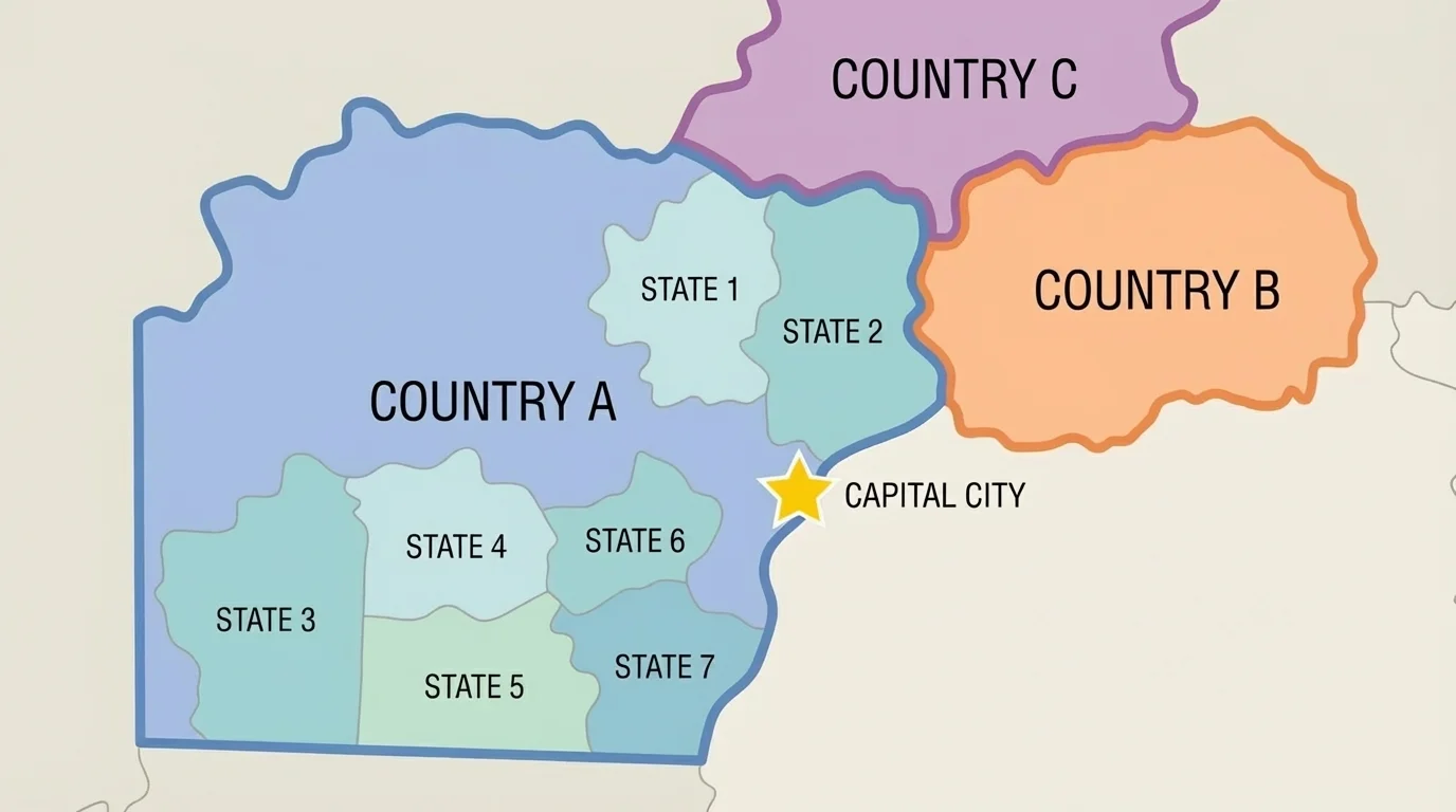
Not all regions are based on nature. Some are based on government. As [Figure 2] illustrates, a political feature is a human-made boundary or place, such as a country, state, county, or city. Governments draw borders on maps, and these borders help create political regions.
A political region may be a nation like Mexico or Canada. It may also be a state like Texas or Florida. Inside a state, there may be counties and cities. Each level can be part of a political region. These regions often have rules, leaders, services, and maps that help organize people and places.
Political regions often have exact borders. For example, one state ends where another begins. A city has an official boundary. These borders matter because laws, schools, road signs, and services may change from one place to another. One side of a border may be in one town, and the other side may be in a different town.
Political regions are important in everyday life. Mail is sorted by cities and states. Elections are held in political areas. Police, firefighters, and schools serve people in certain districts. Even if two places look similar physically, they may belong to different political regions and follow different rules.
Maps often help us tell the difference between physical and political regions. A physical map shows landforms and water. A political map shows borders and cities. If you looked at a political map and saw lines for states and dots for capitals, you would know you were studying government-made regions. The border patterns in [Figure 2] help make this difference clear.
Another way to describe a place is by culture. Culture means the beliefs, customs, languages, foods, music, art, and traditions of a group of people. A cultural region is an area where many people share parts of the same culture.
For example, people in a region may celebrate some of the same holidays, speak the same language, or enjoy similar foods. In one region, many people may eat rice often. In another region, bread or corn may be more common. In one place, people may speak Spanish. In another, they may speak English, French, or many languages together.
Cultural regions do not always match political regions. One language can be spoken in many countries. One country can contain many cultural groups. This is why geographers look at more than one kind of feature. To understand a place well, they ask not only who governs it, but also how people live there and what traditions matter to them.
Culture helps make places special. Buildings, clothing, music, food, celebrations, and religion can all help describe a region. Cultural features are created by people and passed from one generation to the next. They can change over time, but they also help communities feel connected.
A community near the ocean might have seafood in its meals and festivals about boats or fishing. A community with many immigrants may have restaurants, languages, and celebrations from many parts of the world. These cultural clues tell us a lot about a region even when the land looks similar to another place.
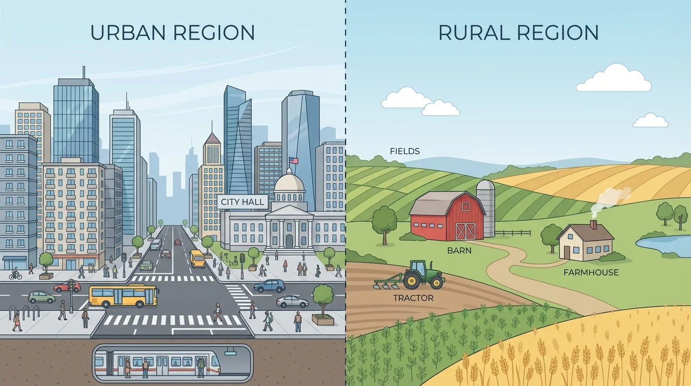
One of the easiest ways to compare regions is to look at whether they are urban or rural. Urban places are cities or large towns where many people live close together. Rural places are areas in the countryside where homes and buildings are farther apart. The contrast between these kinds of places is easy to notice, as [Figure 3] shows.
Urban regions often have tall buildings, apartment buildings, busy roads, buses, trains, stores, schools, offices, and many jobs. There is less open space because many people live and work in the same area. New York City is an example of a very urban place. It has crowded streets, subways, bridges, and neighborhoods packed closely together.
Rural regions often have farms, ranches, forests, mountains, or open land. Houses may be far apart. There may be fewer stores and smaller roads. People may travel longer distances to reach school, shopping, or work. A farming community in Iowa or Nebraska is an example of a rural region with wide fields and fewer people per area.
Some places are in between urban and rural. Small towns and suburbs may have houses, schools, and stores, but also more space than a big city. Geographers compare how crowded a place is, how land is used, and what kinds of jobs people do.
| Type of place | Common features | Example clue |
|---|---|---|
| Urban | Many buildings, crowded roads, stores, public transportation | City skyline |
| Rural | Open land, farms, fewer homes, fewer people | Fields and barns |
| Small town or suburb | Mix of homes, schools, local stores, more space than a city | Neighborhood streets |
Table 1. Comparison of urban, rural, and in-between places by common visible features.
Urban and rural features matter because they affect daily life. In urban regions, people may ride buses or walk to stores. In rural regions, people may drive longer distances and use more land for farming. The side-by-side view in [Figure 3] helps show why the same state can include very different kinds of communities.
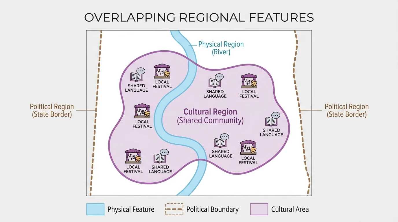
As [Figure 4] illustrates, a place does not belong to only one region. It can be part of several regions at the same time. One community may be in a mountain region, inside a certain state, and also part of a cultural region where people share language and traditions. Geographers often think about these overlapping regions.
For example, a town in Arizona may be in the desert physical region, in the political region of Arizona and the United States, and in a cultural region shaped by Native American, Mexican, and American traditions. Each description is true. Each tells us something different about that place.
This is an important idea because no single feature explains everything about a place. If we looked only at weather, we would miss government and traditions. If we looked only at borders, we would miss landforms and language. Studying regions means putting many clues together.
Case study: One place, many regions
Look at a town near a river in a farming state.
Step 1: Identify physical clues.
The river, flat land, and rich soil suggest a river valley or plains region.
Step 2: Identify political clues.
The town belongs to a city, county, state, and country.
Step 3: Identify cultural clues.
Shared foods, festivals, music, and languages connect people in the community.
Step 4: Identify urban or rural clues.
If there are fields and few buildings, it is likely rural. If there are crowded streets and many tall buildings, it is likely urban.
One place can be described in all of these ways at once.
The layered picture in [Figure 4] reminds us that regions are tools for understanding places, not just labels on a map.
Let us look at a few examples. The desert Southwest in the United States is a physical region with dry land, hot summers, and plants such as cacti. It is also a cultural region with foods, art, and traditions shaped by Native American, Mexican, and American influences. Cities such as Phoenix are urban parts of this larger region.
The Great Plains are mostly flat grasslands in the middle of North America. This physical region has open land and is important for farming and ranching. Many parts of the Great Plains are rural because people live farther apart and much land is used for crops and livestock.
New York City is part of the political region of New York State and the United States. It is also an urban region with dense neighborhoods, subways, bridges, and many jobs. Culturally, it is known for many languages, foods, and celebrations because people from around the world live there.
A small farming town in the Midwest may be part of a rural region, a political region inside a state, and a cultural region shaped by county fairs, local sports teams, and farming traditions. Comparing these examples helps us see how geographers use different kinds of features to describe places carefully.
Regions help shape how people live. In snowy regions, people wear warm clothes and use snowplows on roads. In coastal regions, people may fish, sail, or work in ports. In fertile farming regions, many people grow crops because the land and climate support farming.
People also change regions. They build roads, bridges, homes, and cities. They cut tunnels through mountains, dam rivers, and create parks. Farmers change land into fields. Builders turn open land into neighborhoods. These changes can make a region look different over time.
Maps, globes, and compass directions help us locate places. To describe a region well, we use those map skills together with details about land, people, and communities.
Sometimes people want to protect a region. They may create national parks to save forests, deserts, or mountains. They may protect historic neighborhoods or cultural sites that are important to a community. This shows that regions are not only places on maps. They are places where people live, work, celebrate, and care for the environment.
Maps give us important clues about regions. A physical map may show mountains in brown, plains in green, and water in blue. A political map may show borders, capital cities, and state lines. A road map may show highways and towns. Each kind of map tells part of the story.
Geographers also use photographs, satellite images, charts, and observation. They may ask: Are there many farms? Are there apartment buildings? What language is on signs? Is the land flat, forested, snowy, or dry? The answers help them describe the region more fully.
When you characterize a region, you are doing more than naming it. You are explaining what makes it special. You are noticing patterns. You are comparing places. You are using evidence from nature and from human life. That is what geographers do when they study the world.