Colorado is one of the highest states in the United States, but that does not just mean tall mountains. It also means Colorado has cold snowy peaks, wide grasslands, important rivers, busy cities, and roads and rail lines that connect it to many other places. Geography becomes exciting when we stop memorizing facts and start asking questions like: Why are there so many ski towns in Colorado? Why do some parts of Colorado grow crops while others have forests? How does water from Colorado reach other states?
Geography is the study of places and how people and nature interact in those places. Geographers ask questions, gather information, compare places, and look for patterns. When we create geographic questions about Colorado in relation to other places, we are trying to understand how Colorado is similar to and different from the states and regions around it.
A geographic question asks about where something is, why it is there, how it is connected to other places, or what happens because of that location. Good questions help us think deeper than simple facts. For example, "Where is Denver?" is a starting question. "Why did Denver grow into a large city in this location?" is a stronger geographic question because it asks about place, movement, and human activity.
Geographers often study five big ideas: location, place, region, movement, and human-environment interaction. Location tells where something is. Place describes what it is like there. A region is an area that has features in common. Movement is how people, goods, and ideas travel. Human-environment interaction is how people affect the land and how the land affects people.
Geographic question means a question about places, locations, patterns, and connections between people and the environment. These questions often begin with words like where, why, how, and what patterns.
Colorado gives us many chances to ask these kinds of questions. We can ask why mountain towns are smaller than cities on the plains, why roads are built differently in steep areas, or why rivers are so important in a state with dry regions. Each question helps us understand Colorado better by comparing it to other places.
A strong geographic question is clear and specific. It should focus on a place and connect that place to evidence we can study. Instead of asking, "Is Colorado cool?" a better question is, "How is Colorado's climate different from the climate of Arizona?" That question can be answered by using maps, weather data, and examples from real places.
Geographic questions often use comparison words. These words include similar, different, closer, farther, higher, and lower. A question like "How are the Rocky Mountains in Colorado different from the Great Plains in Kansas?" helps students notice landforms, elevation, and how people use the land.
Here are some examples of strong geographic questions about Colorado in relation to other places:
These questions are useful because they can be answered with evidence, not guesses. That is one of the most important ideas in geography.
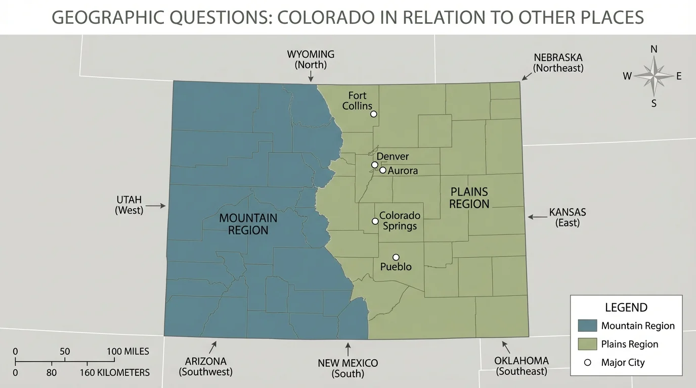
To answer questions about places, geographers use tools. As [Figure 1] shows, a Colorado map can include several important features. A map scale helps show distance, a legend explains symbols, and a compass rose shows direction.
A map title tells what the map is about. The legend explains what colors and symbols mean. The compass rose points north, south, east, and west. The scale helps us estimate distance. For example, if the scale shows that a certain line equals 100 miles, we can compare how far Denver is from Grand Junction or Colorado Springs.
Geographers also use atlases, globes, digital maps, and charts. Digital maps can show roads, rivers, elevation, weather, or population. An atlas is a book of maps, while a globe shows the round shape of Earth. Each tool is useful for a different kind of question.
Another important tool is geographic data. Data are pieces of information such as temperature, rainfall, elevation, or population. If students ask, "Which part of Colorado gets the most snow?" they can look at snowfall data and mountain maps. If they ask, "Where do most people in Colorado live?" they can use population maps and city maps.
Using map features together
Geographers rarely use just one map feature at a time. They may use the title to know the topic, the legend to understand colors, the compass rose to follow direction, and the scale to estimate distance. When these features work together, a map becomes a powerful tool for answering questions.
When we compare maps, we learn even more. A physical map shows landforms such as mountains and plains. A political map shows borders, states, and cities. A climate map shows temperature and precipitation patterns. Looking at several maps together helps us build better answers.
When we compare Colorado with nearby places, [Figure 2] helps us see how its location connects it to many states and regions. Colorado is in the western half of the United States, but it also touches the Great Plains, so it is a meeting place of mountains and flatter grasslands.
Colorado has seven neighboring states: Wyoming, Nebraska, Kansas, Oklahoma, New Mexico, Arizona, and Utah. This is unusual and helps make Colorado an important crossroads. To the west are mountains, plateaus, and desert areas. To the east are plains that stretch into Kansas and Nebraska. This location affects travel, farming, weather, and trade.
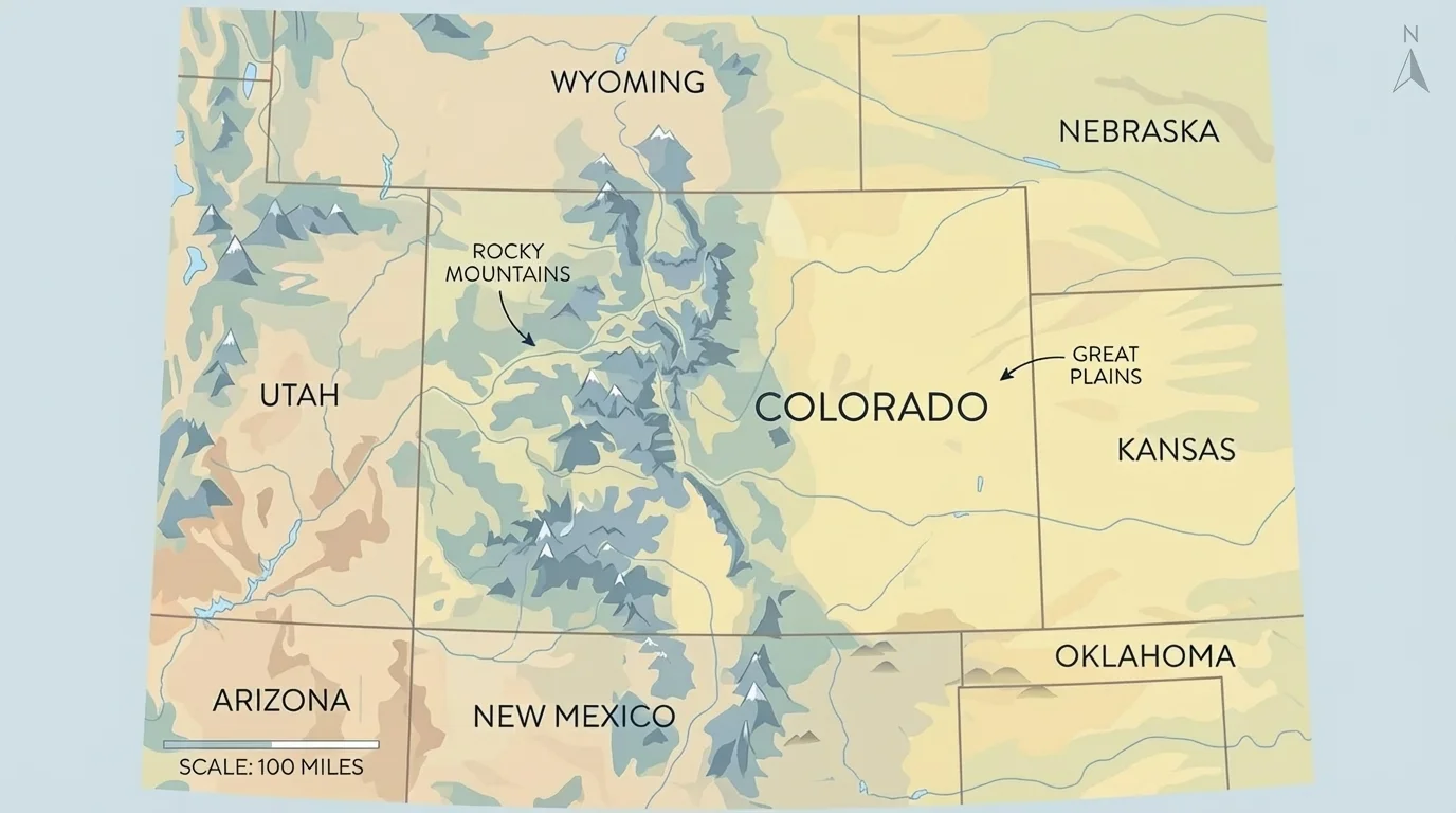
One of Colorado's most famous physical features is the Rocky Mountains. These mountains run north to south through much of the state. Eastern Colorado is part of the Great Plains, which are flatter and better for large-scale farming. This means Colorado includes more than one major region, which is why geographic questions about Colorado are often really questions about different parts of Colorado.
Colorado is also known for high elevation. Many parts of the state are far above sea level, and this can affect weather, transportation, and recreation. Higher places are often cooler and receive more snow. That is one reason skiing is so important in Colorado's mountain areas.
Colorado is often called the highest state because its average elevation is higher than that of any other state. Even places that seem flat in eastern Colorado are still high above sea level compared with many places in the United States.
Colorado's location matters for rivers too. Some rivers that begin in Colorado flow into other states. Water is a major connection between places, especially in the dry western United States.
Comparing places helps geographers notice patterns and differences. [Figure 3] organizes several states by their major landscapes. Colorado is not just "mountains." It includes snowy peaks, forests, valleys, plateaus, and plains. Comparing Colorado with Kansas, Arizona, and California shows how geography shapes daily life.
Colorado and Kansas are neighbors, but they look very different in many areas. Kansas is mostly flat or gently rolling, while Colorado rises from plains in the east to high mountains in the center and west. Because of this, Colorado has more ski resorts and mountain passes, while Kansas has wider areas that are easier for large farms and roads.
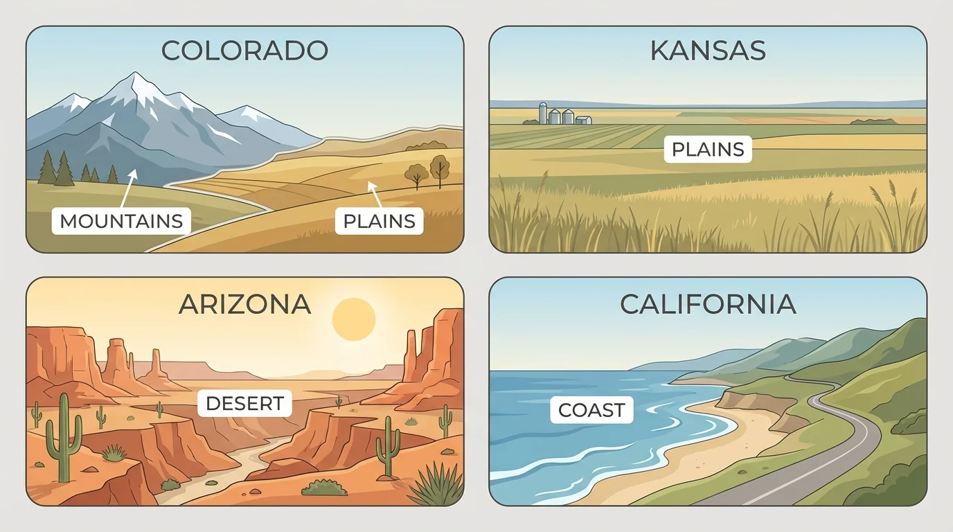
Colorado and Arizona both have dry regions, but Arizona is generally hotter and has larger desert areas. Colorado has colder high elevations and more snow in mountain regions. So a geographic question such as "Why are cactus plants common in Arizona but not in most Colorado mountain areas?" can be answered by comparing climate and elevation.
Colorado and California also differ in important ways. California has a long Pacific coast, while Colorado is landlocked, meaning it has no ocean coastline. This affects trade, climate, and tourism. California's coast supports ports, fishing, and beach tourism. Colorado's mountains support skiing, hiking, and mountain tourism. The land itself helps shape jobs and recreation in each state.
| Place | Main Landforms | Climate Clues | Human Activities |
|---|---|---|---|
| Colorado | Mountains, plains, plateaus | Cold snowy mountains, drier plains | Skiing, ranching, farming, city life, tourism |
| Kansas | Plains | Less mountain snow, more open grassland | Farming, transportation, ranching |
| Arizona | Deserts, plateaus, some mountains | Hotter and drier in many areas | Desert tourism, city growth, farming with irrigation |
| California | Coast, valleys, mountains | Mild coast, varied inland climate | Ports, farming, technology, beaches, tourism |
Table 1. Comparison of Colorado and three other states by landforms, climate, and human activities.
As we saw earlier with the map tools in [Figure 1], these comparisons become stronger when students use real evidence. A physical map can show landforms, and a climate map can show wet and dry areas. Geography is about proving answers with information.
Let us look at a few important questions about Colorado and answer them like geographers.
Case study 1: Why are ski towns common in Colorado?
Step 1: Identify the location of ski towns.
Many ski towns are in or near the Rocky Mountains.
Step 2: Look at physical features.
Mountain areas have high elevations, steep slopes, and colder temperatures.
Step 3: Connect climate to human activity.
Because these places get snow in winter, people can ski and snowboard there.
The answer is supported by landform and climate evidence. A similar question about Florida would lead to a different answer because Florida does not have Colorado's high snowy mountains.
Another strong question is: Why are farms more common in eastern Colorado than in the high mountains? The answer involves flatter land, easier travel, and more space for fields. Mountains can be beautiful, but they are harder places for large machines and wide crop fields. This shows how human activities depend on the land.
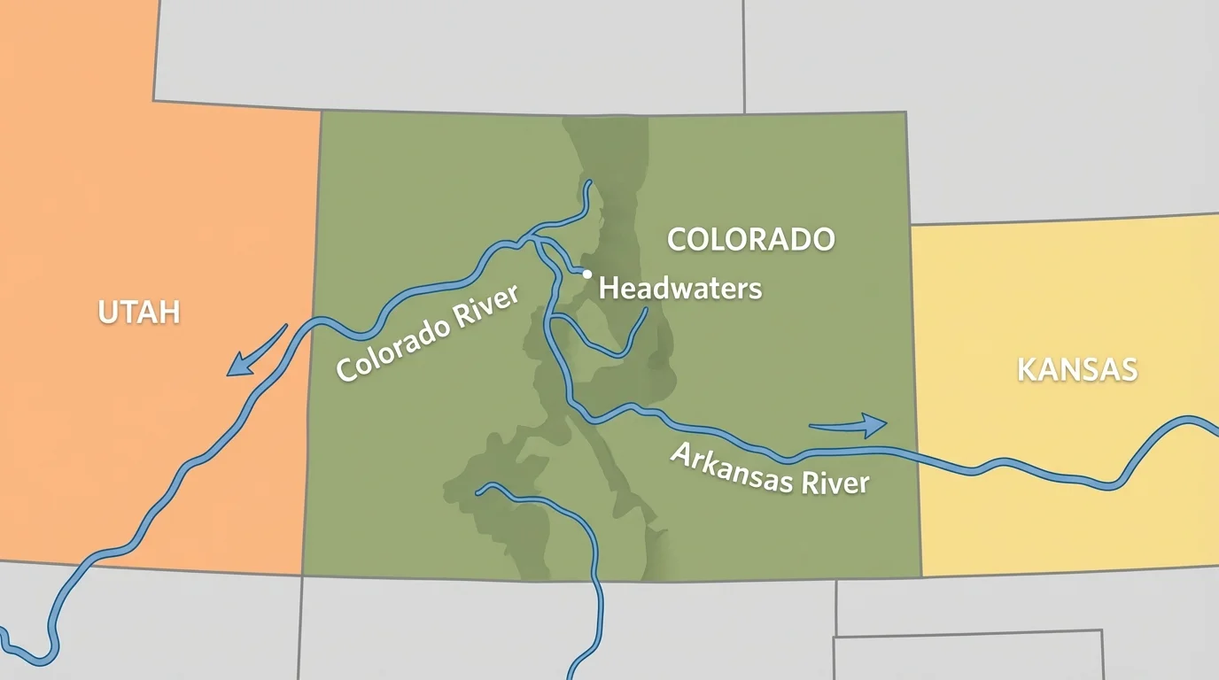
Water creates another important set of questions. [Figure 4] shows that rivers do not stop at state borders. They connect Colorado to farms, cities, and ecosystems in other states.
The Colorado River begins in the Rocky Mountains and flows west. The Arkansas River begins in Colorado too and flows eastward into other states. This means snow and rain in Colorado can matter to people far away. A question like "How does water from Colorado affect other places?" can be answered by tracing river paths and learning who uses that water.
A third question might be: Why are large cities such as Denver located where they are? Denver grew where transportation routes, nearby resources, and access to both plains and mountains made it a useful place for settlement and trade. Cities often grow where geography offers advantages.
Later, when we think about Colorado's connections to other states, the river routes in [Figure 4] remind us that geography is not only about borders. Natural systems like rivers and mountain ranges often connect places more strongly than lines on a political map.
Good answers in geography include evidence from tools and data. A student might say, "Eastern Colorado has more farming than mountain areas because maps show flatter land there." That is better than saying only, "I think farming is easier there." Evidence makes the answer stronger.
Evidence can come from many sources:
Suppose we ask, "How does Colorado's location help transportation?" We could use a map to find interstate highways, rail lines, and major cities. Colorado's location in the western United States allows movement between different regions of the country. Mountain passes are harder to cross than flat land, so transportation routes often follow easier paths.
Remember that a map is not just a picture. It is a tool for finding patterns. The direction symbols, colors, labels, and scale all give clues that help answer questions.
Some geographic questions have more than one answer. For example, "Why do people live in Colorado?" may involve jobs, climate, scenery, transportation, and natural resources. Geographers often combine several kinds of evidence to explain one pattern.
Geographic questions help people make decisions in real life. Farmers ask where water is available and what land is best for crops. Travelers ask which roads cross mountains safely. City planners ask where new neighborhoods, schools, or parks should go. Emergency workers ask which places are at risk for wildfire, flood, or heavy snow.
Tourism is another real-world example. Colorado's mountains attract skiers, hikers, and campers, while its plains support ranching and farming. If we compare Colorado with coastal states, we see that landforms influence why people visit. Geography helps explain why one place becomes famous for beaches and another for snow sports.
Weather is also connected to location. Mountains can cause colder temperatures and more snow at higher elevations. Plains can have different wind and storm patterns. By asking good geographic questions, people can better understand the places where they live and travel.
"Geography is the story of places and the connections between them."
When students investigate Colorado in relation to other places, they are doing the real work of geography. They are noticing patterns, asking why those patterns happen, and using evidence to support their thinking. Colorado becomes more meaningful when we see it not as one simple place, but as a state linked to mountains, plains, rivers, cities, and neighboring states.