Colorado may look wild and natural, with snowy mountains, grassy plains, and rushing rivers, but people have changed many parts of the state in big ways. Roads cross mountain passes. Cities spread across the Front Range. Water is moved to farms and towns. Old mining camps became tourist stops or ghost towns. When geographers study these changes, they ask a powerful question: What did this place look like before, and what does it look like now?
To answer that question, geographers use tools such as maps, photographs, timelines, and satellite images. A place can change slowly over many years or quickly when people build, dig, plant, or travel there. Colorado is a great state for studying this because it has mountains, plains, valleys, rivers, and cities that all show different kinds of change.
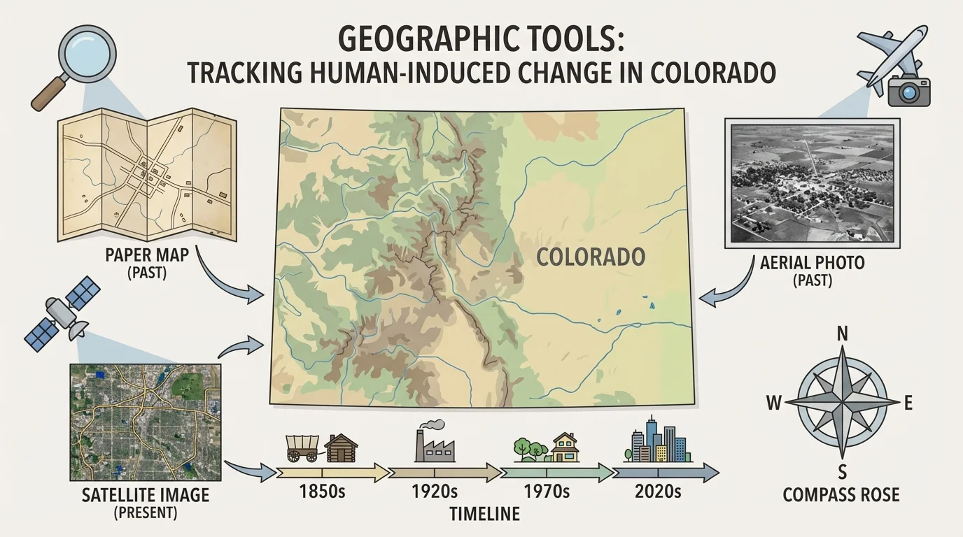
Using geographic tools helps us compare places across time, and [Figure 1] shows that geographers do not rely on just one source of information. They may use a road map to find location, an old photograph to see what a town looked like long ago, a satellite image to spot buildings and land use today, and a timeline to place events in order.
These tools help answer questions such as: Where did a town begin? Which direction did it grow? How did railroads, highways, farms, or ski resorts change the land? Why did people choose that location? A compass rose, map key, and scale can also help geographers understand direction, symbols, and distance on a map.
One useful idea is the difference between physical features and human features. Physical features are parts of nature, such as mountains, rivers, mesas, and plains. Human features are made or changed by people, such as towns, highways, farms, reservoirs, tunnels, and neighborhoods. In Colorado, human features are often built because of physical features. For example, rivers provide water, mountain passes provide routes through high land, and flatter plains provide room for large farms and cities.
Physical features are natural parts of Earth, such as mountains, rivers, and plains. Human features are places or structures built or changed by people, such as roads, dams, towns, and farms. Development means growth and change as people use land and resources over time.
Geographers also use words like land use, which means how people use land. Land use can include housing, farming, mining, shopping, transportation, and recreation. When land use changes, the look and purpose of a place can change too.
A place changes over time when its buildings, roads, population, land use, or natural environment become different from the past. Sometimes these changes are easy to see. A small settlement might become a large city. A valley with few buildings might later have ski lifts, lodges, and parking lots. A grassland might become a neighborhood or a farm.
Some changes happen because people are searching for resources. In Colorado, gold, silver, and other minerals drew miners into the mountains in the nineteenth century. Some changes happen because people need water, transportation, and homes. Other changes happen because people want places to visit for fun, like ski towns and national park gateways.
Colorado has both densely populated urban areas and remote mountain regions, so one state shows many different types of human change in one place.
Change is not always only about adding new things. It can also mean removing forests, excavating land, rerouting rivers, or leaving places behind. Some former mining towns became much smaller after the minerals ran out. Some old railroad routes are no longer used the same way they once were. Studying both growth and decline helps us understand development more clearly.
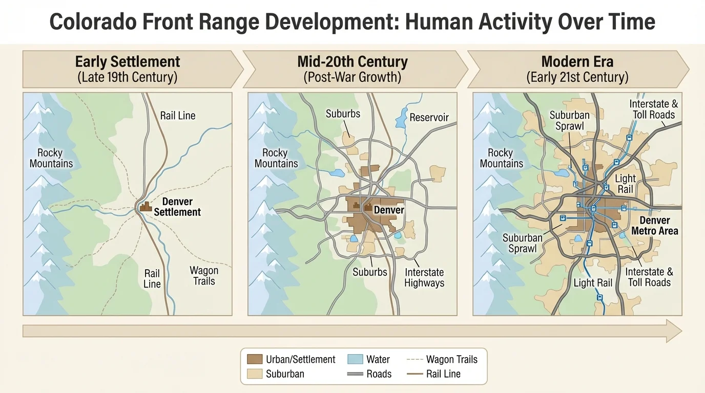
The Front Range is the area where the plains meet the mountains, and it includes some of Colorado's biggest cities. Denver began as a much smaller settlement than it is today. Over time, as transportation, trade, and population increased, the city spread outward, as [Figure 2] illustrates, into more neighborhoods, roads, schools, and businesses.
Old maps of Denver show a smaller built-up area. Newer maps and satellite images show a much wider urban region with highways, suburbs, parks, and airports. This is a strong example of development caused by human activity. People built homes, stores, office buildings, sports stadiums, and transportation systems. Land that may once have been open prairie became part of a busy metropolitan area.
Geographers can compare historical maps and modern satellite images to see patterns. They may notice that growth often follows major roads, rivers, and flatter land. They may also notice that cities along the Front Range connect with one another more than they did in the past. Denver, Colorado Springs, Fort Collins, and nearby communities have all grown as more people moved to the region.
This growth brought benefits. More people meant more jobs, schools, hospitals, and services. Transportation improved with highways and rail connections. But growth also brought challenges. As cities spread, open land and wildlife habitat became smaller in some areas. Traffic increased. More people also meant a greater need for water and energy.
Case study: reading Denver's change with tools
Step 1: Look at an older map of Denver.
The map shows a smaller city center and fewer roads.
Step 2: Compare it with a recent satellite image.
The newer image shows many more neighborhoods and highways spreading outward.
Step 3: Ask what caused the change.
Population growth, transportation, and business development all helped expand the city.
Using more than one tool makes the pattern of change easier to understand.
Later in the lesson, when we compare different tools again, keep Denver in mind. The same place can tell different stories depending on whether we look at roads, land use, or population patterns.
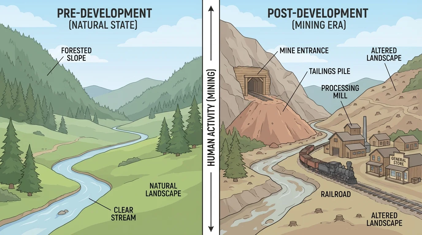
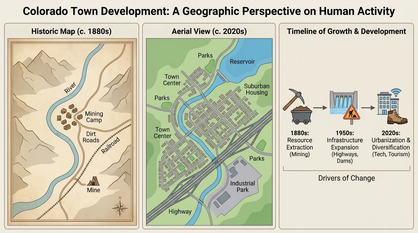
Colorado's mountains contain many places shaped by mining. In the past, people traveled into high valleys and steep slopes searching for gold, silver, and other minerals. Human activity changed the landscape quickly, and [Figure 3] shows how roads, rail lines, mine entrances, and tailings piles could appear in places that had once been mostly natural land.
Towns such as Leadville, Central City, and Silverton grew because mining brought workers, supplies, and businesses. Buildings were constructed close together. Roads and narrow railroads were built to move ore and people. In some places, tunnels were cut into mountainsides. Streams and hillsides were affected by digging and dumping rock.
Maps help geographers notice where mining towns were located. Many are near mountain resources and transportation routes. Historical photographs help students see what the towns looked like when they were active. Modern photographs can show whether those places are still busy, used for tourism, or mostly abandoned.
Mining changed more than just the economy. It changed the shape and use of the land. Some forests were cut for buildings and fuel. Water could become polluted by mining waste. At the same time, mining created communities that are important parts of Colorado history. Today, some former mining towns attract visitors who want to learn about the past.
"Places tell stories if we know how to read the land."
This idea matters in Colorado because the land still shows signs of earlier human decisions. A geographer can often tell that a town was once a mining town by noticing its location, rail routes, steep mountain setting, and old structures, much like the pattern visible in [Figure 3].
Not all human change in Colorado happened in cities or mountain mines. Large parts of the state were changed by farming. On the plains and in some valleys, people used the land for crops and livestock. To make farming possible in drier areas, people built systems to move and store water.
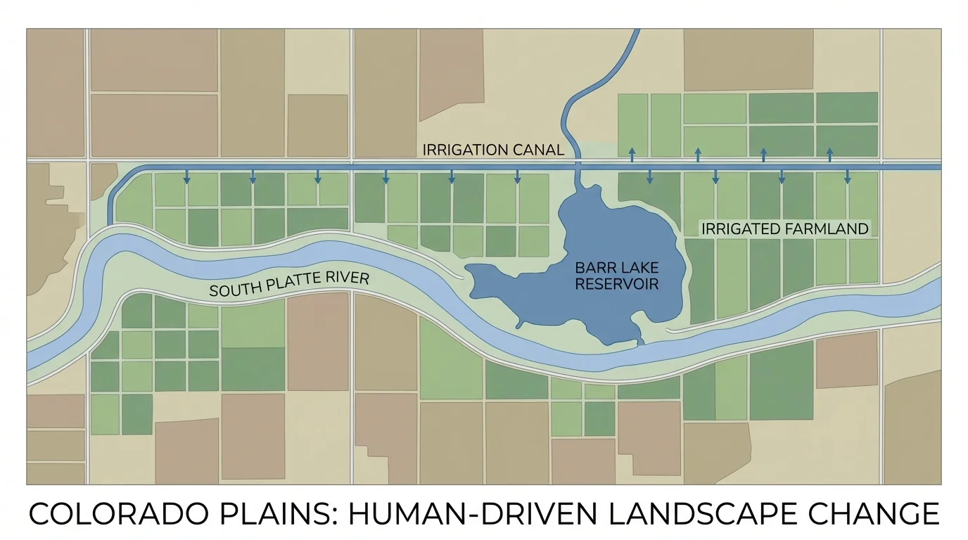
A irrigation system sends water to fields where rainfall alone may not be enough. Geographers can trace this movement of water on maps, and [Figure 4] shows how rivers, reservoirs, canals, and farm fields connect. A river might flow naturally through one area, but people may build a dam or canal to direct part of the water elsewhere.
On many maps, farm fields appear as regular shapes, especially rectangles or circles, unlike the more irregular shapes of natural land. This pattern is an important clue. It tells geographers that land has been measured, divided, and used by people. Aerial photographs are especially helpful because they show these shapes clearly from above.
Reservoirs are another major human change. A reservoir is a human-made lake used to store water. In Colorado, reservoirs support cities, farms, and recreation. But storing and moving water also changes river systems and affects habitats for plants and animals.
Water use is especially important in Colorado because much of the state has a dry climate. Even though mountain snow provides water, that water must be carefully managed. Human activity has made it possible for farms and cities to grow in places that otherwise would have had less water available.
Why water changes development
Water often decides where people can live, farm, and build. In Colorado, moving water through dams, canals, and reservoirs allows more land to be used by people. This helps communities grow, but it can also reduce natural river flow and change habitats.
When students study a farming area, they should ask: Where does the water come from? How was the land divided? What natural features made farming easier or harder? These questions connect land use to human decision-making.
Colorado is famous for skiing, hiking, and mountain vacations. Many mountain towns have changed because of tourism. A place that may once have been small or focused on mining or ranching might later develop hotels, restaurants, shops, lifts, and vacation homes.
Towns such as Aspen, Vail, and Breckenridge show how recreation can reshape a place. Roads are improved so visitors can reach the town. Parking areas, lodges, and trails are built. Slopes are cleared and managed for skiing. New jobs appear in travel, dining, lodging, and outdoor sports.
Maps can show where ski towns are located in relation to mountain ranges, highways, and rivers. Satellite images can show ski runs and developed resort areas. Historical photographs may reveal that some of these places looked very different before tourism expanded.
Case study: how tourism changes a mountain town
Step 1: Start with an older photograph.
The town may show only a few buildings and simple roads.
Step 2: Compare with a recent aerial image.
The newer image may show ski runs, hotels, parking areas, and more houses.
Step 3: Think about why the change happened.
People developed the area for recreation and travel, bringing jobs and visitors.
This kind of development changes both the economy and the landscape.
Tourism can help communities earn money, but it can also increase traffic, raise housing costs, and put pressure on forests, streams, and wildlife. Human activity often brings both opportunities and problems at the same time.
No single tool tells the whole story of change, and [Figure 5] illustrates how a map, an aerial image, and a timeline each reveal something different about one Colorado place. A map helps us locate features and measure distance. An aerial or satellite image helps us see shapes, patterns, and land use. A timeline helps us place events in order.
For example, if students study a town that grew from a railroad stop into a larger community, a timeline shows when important events happened, such as the arrival of the railroad or the opening of a highway. A map shows where growth happened. A photograph or satellite image shows what the place looked like.
Geographers also use legends, symbols, labels, and scale bars. If a road appears on a later map but not on an earlier one, that is evidence of human change. If dark green forest on an image is replaced by buildings or ski runs, that is also evidence. If a timeline shows a mining boom followed by decline, that helps explain why the town's size changed.
Think back to Denver and the Front Range. As we saw earlier in [Figure 2], one map can show urban spread, while a newer satellite image shows how highways and neighborhoods filled in the land between places. In the same way, a mining town or farm region becomes easier to understand when we combine several kinds of evidence.
| Tool | What It Helps Us See | Colorado Example |
|---|---|---|
| Map | Location, direction, distance, and symbols | Where Denver expanded along the Front Range |
| Historical photograph | What a place looked like in the past | An older mining town with fewer buildings today |
| Satellite image | Land use patterns and recent development | Farm fields, reservoirs, suburbs, or ski runs |
| Timeline | Order of events over time | When a railroad, dam, or resort was built |
Table 1. Geographic tools and the kinds of evidence they provide about change in Colorado places.
When students ask strong questions, tools become even more useful. Good questions include: What changed? When did it change? Why here? How did people change the land? What effects followed? These are the same kinds of questions geographers ask in real research.
Human activity can improve life in many ways. Development can create jobs, homes, transportation, and places for learning and fun. Cities offer services. Farms provide food. Roads connect communities. Ski towns create recreation and business.
But every change has effects on the environment too. Building over open land can reduce habitat. Mining can leave scars on the land and affect water quality. Using more water for farms and cities can change rivers. More traffic and energy use can increase pollution. Understanding these effects helps people make smarter choices in the future.
Remember that Colorado's physical features include mountains, plains, plateaus, and rivers. Human decisions often depend on these natural features, so geography and history work together.
Geographers do not just look for whether change happened. They also study whether the change was balanced and sustainable. That means asking whether people are using land and water in ways that can continue without causing too much damage.
Colorado's places are still changing today. Some cities continue to grow. Some mountain towns welcome more visitors each year. New neighborhoods, roads, and renewable energy projects are added. At the same time, people work to protect forests, rivers, wildlife, and historic places.
Studying change over time helps students become careful observers. When you compare maps, photos, and timelines, you can see that places are not fixed. They are shaped by both nature and people. Colorado's story is written in its mountains, plains, cities, farms, mines, and tourist towns.
A geographer's job is to read that story using evidence. The more tools we use, the clearer the story becomes. By studying how human activity changed Colorado places over time, we learn not only about the past but also about choices that matter for the future.