A bag of Colorado peaches might be picked on the Western Slope, loaded onto a truck, driven through mountain passes, and sold hours later in a grocery store near Denver. At the same time, a doctor in a city hospital might help a patient in a small town by video call. These are two big clues about Colorado: places in the state are always connected, even when they are far apart.
Colorado is a large state with very different landforms. It has tall mountains, wide plains, river valleys, busy cities, and small rural communities. Because of these differences, people must find ways to move goods, provide services, and share technology from one place to another. These connections help people get food, medical care, education, jobs, and information.
Goods are things people make, grow, or sell, such as cattle, peaches, skis, or clothing.
Services are jobs people do to help others, such as teaching, nursing, repairing cars, or guiding tourists.
Technology is the use of tools and systems, such as computers, cell phones, internet networks, and machines, to solve problems and share information.
When geographers study a place, they ask how the physical environment affects human activity. In Colorado, the land itself changes how people travel and connect. Mountains can make travel harder. Flat plains can make travel easier. Snowstorms can close roads. Rivers can help shape towns and farming areas. People build roads, railroads, airports, and communication networks to connect communities across these physical features.
Every day, people in Colorado depend on connections they may not even notice. Milk from dairy farms, wheat from the plains, and equipment from factories all travel to stores. Tourists travel to ski towns for recreation. Students use computers to learn from teachers. Businesses send information from one city to another in seconds.
Some connections are easy to see, like trucks driving on Interstate highways. Other connections are harder to see, like internet signals moving through wires, towers, and satellites. Both matter. A store needs food deliveries, but it may also need online orders, digital payments, and communication with workers in other places.
Colorado's biggest cities, such as Denver, Colorado Springs, Aurora, and Fort Collins, are major centers of movement. They have large populations, many businesses, hospitals, schools, and transportation routes. Smaller towns are also important. They grow crops, raise animals, mine materials, welcome visitors, and provide local services. The state works best when these places stay connected.
Colorado has some of the highest paved roads and mountain passes in the United States. That means moving people and products across the state can be beautiful, but it can also be difficult during bad weather.
Think about a school lunch. Bread may come from wheat grown on the Eastern Plains. Fruit may come from orchards in western Colorado. Milk may come from dairy farms in another county. The lunch reaches a school because many places are linked together.
Colorado's physical environment strongly affects where and how movement happens, as [Figure 1] shows through the state's regions and transportation routes. The Rocky Mountains stretch through the middle of the state. East of the mountains are the Great Plains, which are flatter and more open. West of the mountains are valleys, plateaus, orchards, ranches, and energy-producing areas.
Mountains can slow travel because roads must go around peaks or climb through passes. Building highways and rail lines in steep places takes time, money, and engineering. Snow and ice can make travel dangerous in winter. On the plains, roads can often go straighter for long distances, which helps trucks move crops, cattle, and supplies.
Rivers and valleys also matter. Many towns developed near water because people need water for drinking, farming, and industry. Valleys can create natural paths for roads and railroads. This helps goods and people move more easily than they could over steep mountains.
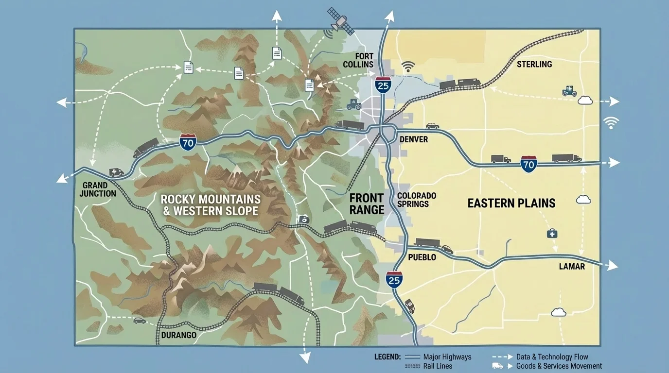
Air travel is important too. Denver International Airport connects Colorado to other states and countries. Smaller airports help mountain towns and rural places stay connected. Planes can move people and some goods quickly, especially over long distances.
The Front Range is a busy urban corridor on the eastern side of the mountains. It includes cities such as Fort Collins, Denver, Boulder, and Colorado Springs. Many people live there, so many roads, rail lines, businesses, and internet systems are concentrated there. This region became a major center partly because it is easier to build large cities near the edge of the plains than in the high mountains.
Later, when we look at regional examples, the patterns in [Figure 1] help explain why some places become transportation hubs while others depend on just a few key roads or passes.
A transportation network moves goods from the places where they are produced to the places where they are needed, and [Figure 2] illustrates how these routes link farms, mines, factories, stores, and homes. Colorado goods include wheat, corn, cattle, peaches, melons, dairy products, lumber, mined materials, and manufactured products.
Farmers on the Eastern Plains grow crops such as wheat and corn. Ranchers raise cattle. These goods are loaded onto trucks or trains and sent to food companies, markets, or processing centers. Because the plains are open, transportation can cover long distances across rural areas.
On the Western Slope, orchards grow peaches and apples. Vineyards produce grapes. These goods often travel to cities along the Front Range, where many customers live. Mountain passes are important because they connect western Colorado to eastern Colorado. If a pass closes because of snow, deliveries may be delayed.
Colorado also has mining and energy areas. Some places produce gravel, coal, oil, natural gas, or other resources. These materials move to factories, power plants, or construction sites. Goods do not only move from rural places to cities. Finished products, tools, clothing, school supplies, and medicine also move from city warehouses to smaller towns.
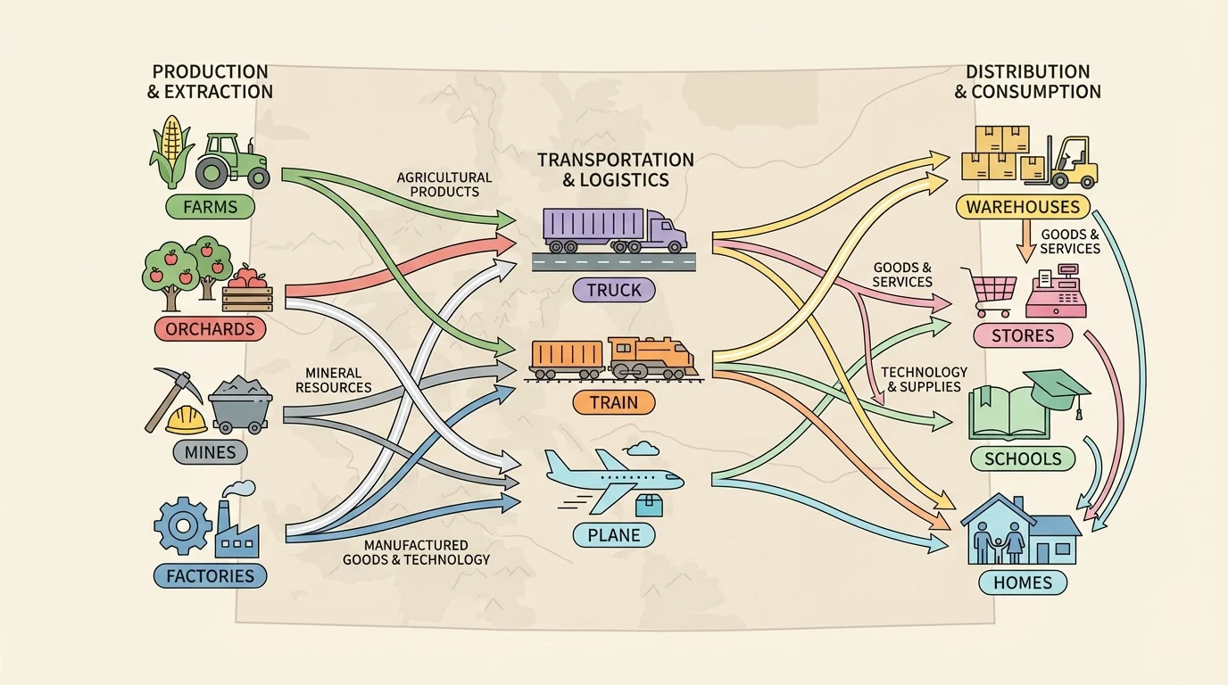
Trucks are especially important because they can deliver directly to stores, schools, restaurants, and homes. Trains are useful for carrying heavy loads over long distances. Airplanes are less common for everyday groceries, but they can move people and special items quickly. Each form of transportation has strengths.
| Type of good | Where it may come from | How it may move | Where it may go |
|---|---|---|---|
| Wheat | Eastern Plains | Truck or train | Food companies, stores |
| Peaches | Western Slope | Truck | Front Range markets |
| Cattle | Ranches across Colorado | Truck | Processing centers, markets |
| Building materials | Mines or factories | Truck or train | Cities and towns |
| Medical supplies | Warehouses in cities | Truck or plane | Hospitals and clinics |
Table 1. Examples of goods, where they may come from in Colorado, how they move, and where they may go.
Stores in mountain towns often depend on goods arriving from other places. A small grocery store may not grow its own food or make its own products. It relies on deliveries from farms, factories, and distribution centers. This is why road closures can affect daily life so quickly.
The flow in [Figure 2] also reminds us that movement goes both ways. Products go to customers, but money, orders, and information move back to the producers and sellers.
Case study: Colorado peaches on the move
A peach picked in Palisade on the Western Slope may travel across the state before a family buys it in Denver.
Step 1: The peaches are grown and picked in an orchard.
Step 2: Workers pack the peaches into boxes and load them onto trucks.
Step 3: The trucks cross mountain routes toward the Front Range.
Step 4: Stores receive the peaches and sell them to customers.
This example shows how farming areas and city markets depend on each other.
Not everything that moves is a physical product. Services also connect places in Colorado. A teacher, mechanic, nurse, park ranger, bus driver, banker, and ski instructor all provide services. Some services happen face-to-face. Others can be shared over distance using transportation and technology.
Tourism is one important service connection in Colorado. Visitors travel from cities to mountain towns for skiing, hiking, fishing, and sightseeing. This movement supports hotels, restaurants, guides, shops, and transportation workers. Mountain towns provide recreation services, while cities provide many of the travelers, supplies, and business connections.
Healthcare is another example. Large cities often have major hospitals with many specialists. Smaller towns may have clinics, but patients sometimes travel to larger medical centers for special care. In some cases, doctors can connect with patients online. That means services can move even when the patient and doctor are not in the same place.
Education connects places too. Students may attend neighborhood schools, but schools also depend on services from outside the community. Books, buses, cafeteria supplies, internet access, teacher training, and online lessons may all come from different places. Colleges and universities in cities can share knowledge and training with people across the state.
Government services connect places as well. State agencies in the capital, Denver, help people in many counties. Emergency services, road maintenance, weather alerts, and public safety systems all link different communities. These services become especially important during fires, floods, or snowstorms.
Services can travel in more than one way. Sometimes people travel to receive a service, such as when a family drives to a hospital or ski resort. Sometimes the worker travels, such as when a repair team goes to a rural town. Sometimes information travels instead, such as when a teacher posts lessons online or a doctor uses video to meet with a patient.
Because Colorado has both crowded urban areas and widely spaced rural areas, services do not look the same everywhere. A large city may offer many services in one place. A small town may offer fewer services locally but connect to other places for the rest.
Technology lets information and services move across distance, and [Figure 3] shows how homes, schools, hospitals, farms, and businesses can be linked by digital systems. People use computers, tablets, phones, fiber-optic cables, cell towers, satellites, and wireless networks to send messages, hold meetings, place orders, and learn new information.
This matters in a state like Colorado because distance and landforms can make travel slow. A family in a small mountain town may use the internet to pay bills, order supplies, watch weather reports, and talk with relatives. A farmer on the plains may use technology to check crop prices, track weather, and operate modern equipment. A business in Denver may work with customers in Grand Junction or Pueblo without driving there every day.
Schools use technology to connect students with information from around the state and beyond. Hospitals use technology for patient records and online communication. Stores use technology to track inventory and accept digital payments. Emergency workers use technology to send alerts and coordinate help during dangerous weather.
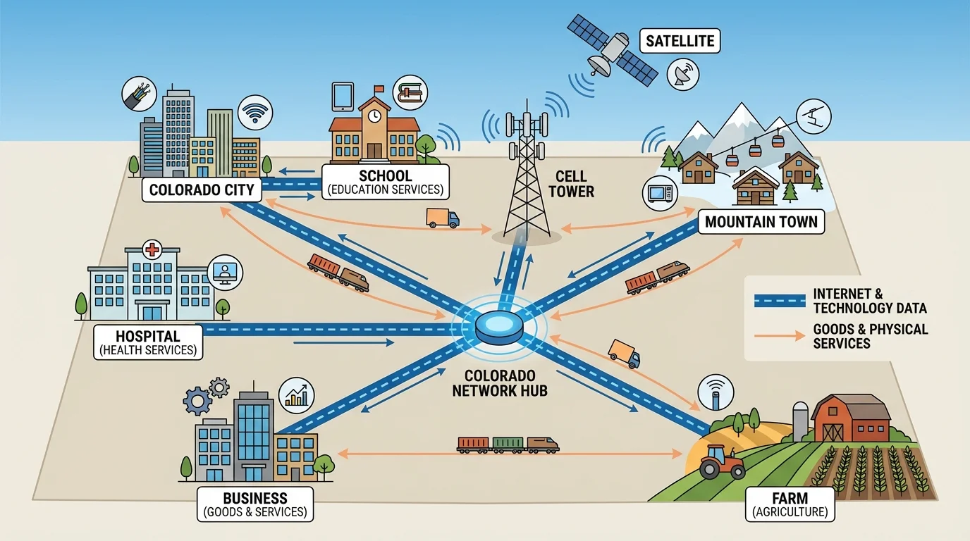
Technology is not separate from the physical environment. Cell towers must be placed in useful locations. Internet cables must be built across land. Bad weather can interrupt systems. Remote places may have weaker service than large cities. This means geography still matters, even in the digital world.
When we compare digital links in different regions later, [Figure 3] helps explain why technology can make faraway places feel closer while still depending on physical structures on the land.
Some students in Colorado can attend classes, complete assignments, or talk with teachers online during bad weather or when schools are far apart. Technology helps learning continue even when travel is difficult.
[Figure 4] compares the Front Range, mountain towns, the Eastern Plains, and the Western Slope. Different parts of Colorado connect in different ways. Each region has its own physical environment, and that shapes how goods, services, and technology move.
The Front Range: This region has many cities and a large population. It is a center for business, government, education, healthcare, and transportation. Goods arrive from all over the state and are sent out again. Services are concentrated here because many customers live nearby. Technology systems are usually strong because cities have many users and businesses.
Mountain towns: These communities often depend on tourism, recreation, and seasonal travel. Roads may be limited, and snow can affect movement. Goods often have to be delivered from outside the area. Services such as lodging, dining, guiding, and ski instruction are important. Technology helps mountain businesses communicate with visitors and manage reservations.
Eastern Plains: This region has large farming and ranching areas with fewer people spread farther apart. Goods such as crops and cattle move out to other places. Services may be fewer in number locally, so people may travel to larger towns for some needs. Technology can help farmers and rural schools stay connected despite distance.
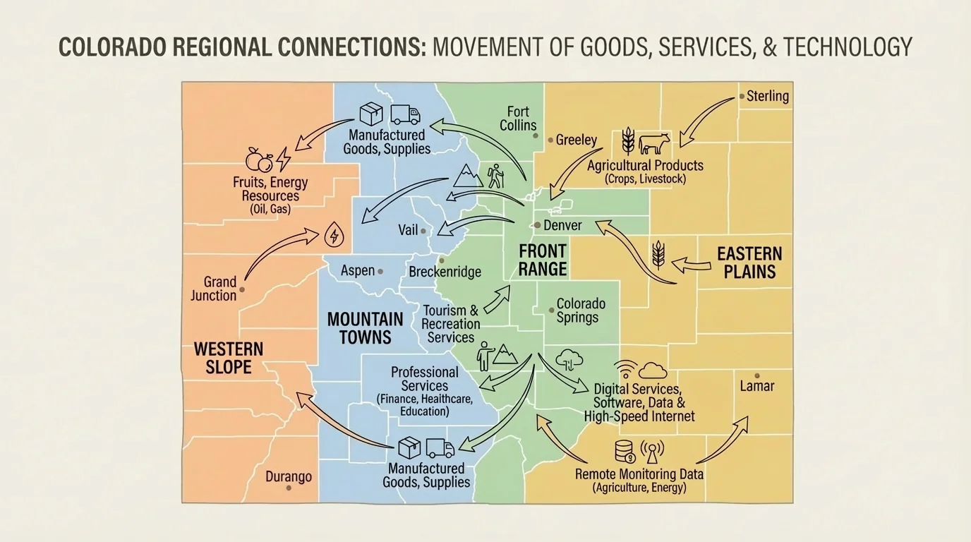
Western Slope: This area includes orchards, vineyards, ranches, river valleys, and energy production. It sends many goods to other parts of Colorado, especially to urban markets. Mountain routes are important links to the rest of the state. Tourism and outdoor recreation also connect this region to visitors from elsewhere.
The regional patterns in [Figure 4] show that no part of Colorado stands alone. A city may rely on food from rural regions. A rural community may rely on city hospitals or warehouses. A mountain town may rely on visitors, online reservations, and delivered supplies. Connections go in many directions.
Connections across Colorado help people meet their basic needs and improve their lives. Food reaches stores. Schools receive materials and internet access. Hospitals get medicine and equipment. Businesses reach customers. Families can travel, work, learn, and communicate across long distances.
These connections also create challenges. Snowstorms may close highways and passes. Wildfires can interrupt travel and communication. Heavy traffic can slow movement in busy urban areas. Rural communities may have longer travel times and weaker internet service. Solving these problems takes planning, engineering, cooperation, and new technology.
People in Colorado continue to adapt to the land. They build roads through mountain passes, maintain rail lines, expand airports, improve internet access, and use new tools to stay connected. The physical environment shapes human activity, but people also respond by creating systems that help communities work together.
When we study movement of goods, services, and technology, we see more than transportation. We see how farms, towns, cities, mountains, and plains form one connected state. Colorado's places are different, but they depend on each other every day.