If the United States had no major rivers, no mountain ranges, and no long coastlines, its history would be completely different. People might have settled in other places, traveled on different routes, fought different battles, and grown different crops. Geography is not just about maps. It helps explain why people moved, where they lived, how they made a living, and how the nation changed over time.
Geography includes landforms, climate, bodies of water, natural resources, and location. History is the story of people over time. When we put geography and history together, we can see that the land itself influences what people do. A mountain can block travel. A river can make trade easier. A warm climate can help certain crops grow. A good harbor can turn a small town into a major city.
Landform means a natural feature of Earth's surface, such as a mountain, valley, plain, or plateau.
Climate is the usual weather of a place over a long period of time.
Natural resource is something found in nature that people can use, such as water, fertile soil, forests, or minerals.
In the history of the United States, geography often affected movement. People moved for land, safety, trade, jobs, and resources. But they did not move just anywhere. They followed rivers, crossed through mountain gaps, sailed into harbors, and settled where the environment could support life.
The earliest English colonies in what became the United States were mostly built along the Atlantic coast. That was not an accident. Colonists arrived by ship, so coastal locations were easiest to reach. They also needed fresh water, fish, and land for farming. Rivers such as the James, Hudson, and Delaware helped people travel inland and transport supplies.
As [Figure 1] shows, natural harbors were especially important. A harbor is a sheltered area of water where ships can anchor safely. Cities like Boston, New York, and Charleston grew partly because they had good harbors. Ships could bring people and goods from Europe and carry products back across the Atlantic Ocean.
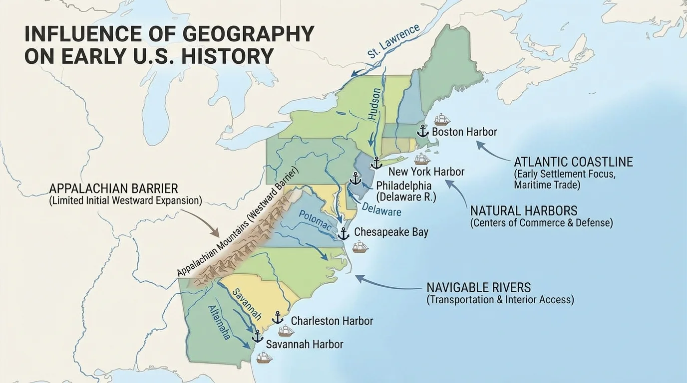
Many colonies also formed near fertile land. In places where the soil was rich and the growing season was long, farming could support larger populations. Coastal plains in the South made it easier to grow crops on a large scale. In New England, rocky soil made farming harder, so many people depended more on trade, fishing, and shipbuilding.
These early patterns mattered for a long time. The coast became the first center of population, government, and trade. Even today, many large eastern cities are located where geography first gave settlers an advantage. The same coast-and-river pattern we saw in [Figure 1] helps explain why the East Coast developed quickly.
Once the colonies grew, many settlers wanted to move west. But the Appalachian Mountains stood like a long wall from north to south. These mountains made travel difficult. Wagons, livestock, and families could not simply move straight across rough ridges and forests.
As [Figure 2] shows, because the mountains were a barrier, routes through them became extremely important. One famous passage was the Cumberland Gap, a low area through the mountains used by Native Americans, explorers, and settlers. Daniel Boone helped make this route better known in the late 1700s. Using places like the Cumberland Gap, settlers entered Kentucky and areas farther west.
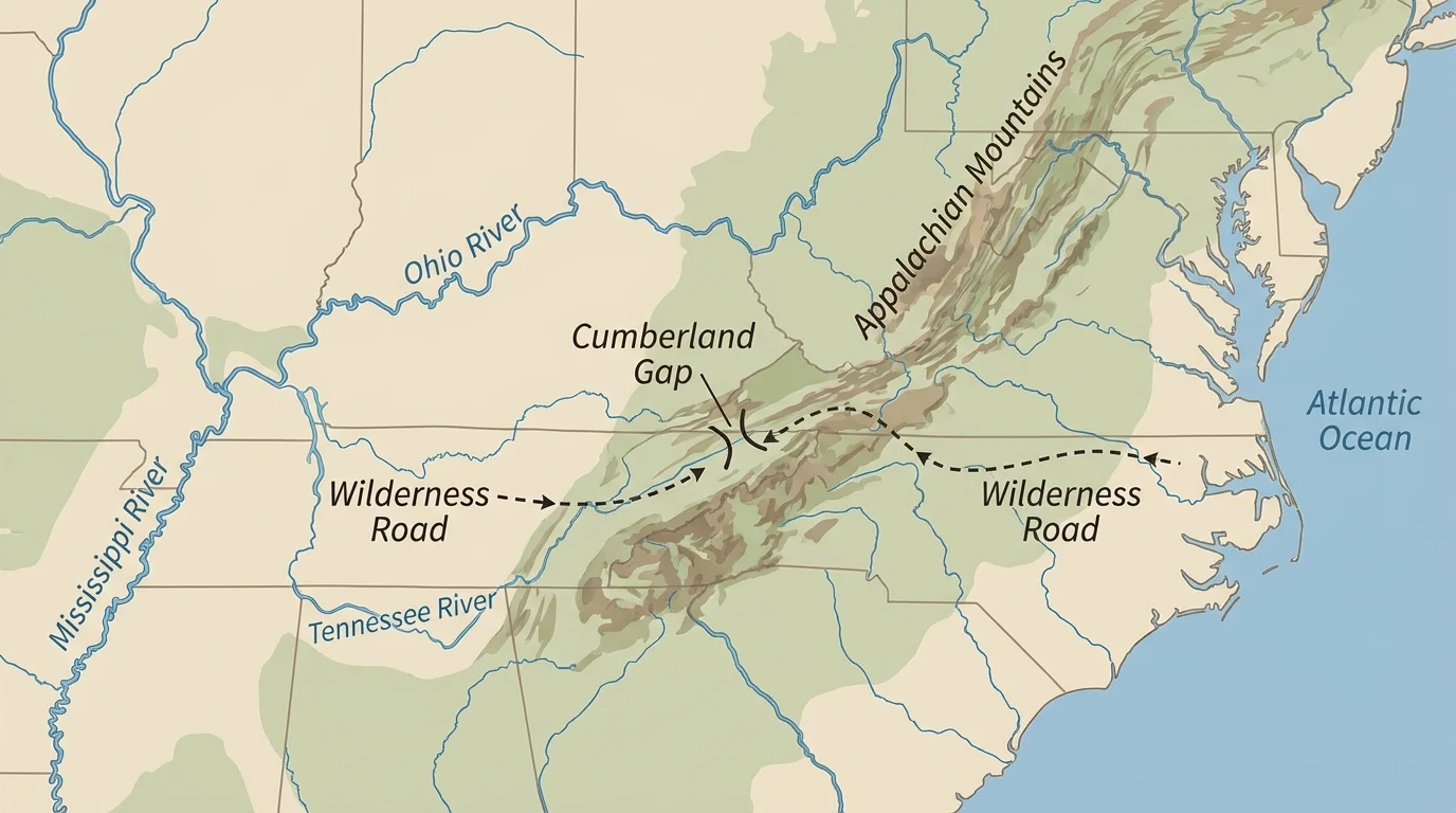
Geography affected politics too. After the French and Indian War, Britain issued the Proclamation of 1763, which tried to limit settlement west of the Appalachians. One reason was that the mountains marked a natural dividing line. Many colonists were angry because they wanted to cross into western lands.
Later, westward expansion continued. The Appalachians slowed movement, but they did not stop it forever. As more roads were built and more people crossed mountain passes, new settlements spread into the interior. This is a clear example of geography shaping both the causes and consequences of movement: the mountains delayed migration, and the successful crossing of the mountains led to growth in new regions.
Before cars, trains, and airplanes, rivers were like the nation's early highways. The huge river system in the center of the country connected the interior to the Gulf of Mexico. The Mississippi River and its major branches, including the Ohio and Missouri Rivers, allowed people and goods to move over long distances.
As [Figure 3] shows, farmers in the interior could load crops onto flatboats or steamboats and send them downstream. Towns and cities often grew up along these waterways because trade was easier there. New Orleans became especially important because it sits near the mouth of the Mississippi River, where goods from the interior could be shipped to other places.
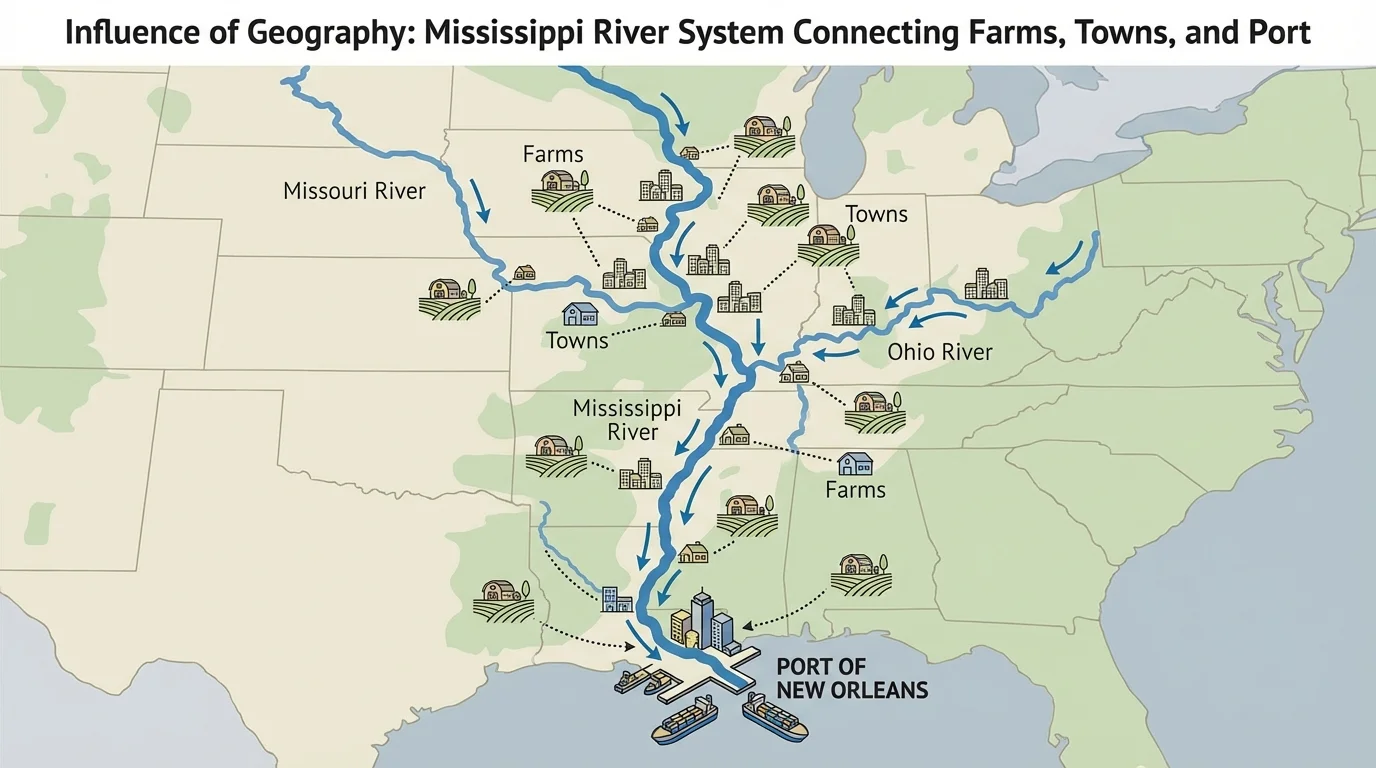
The Louisiana Purchase in 1803 was influenced by geography as well as politics. President Thomas Jefferson wanted control of the port of New Orleans and the river system connected to it. If another country controlled that key location, western farmers could be blocked from shipping goods easily. Buying the Louisiana Territory gave the United States more control over movement and trade in the heart of the continent.
Case study: Why New Orleans mattered
Step 1: Farmers in places far from the Atlantic coast still needed to sell goods.
Step 2: Rivers offered a cheaper and faster way to move heavy products than rough overland roads.
Step 3: Goods moved down the Ohio and Mississippi Rivers to New Orleans.
Step 4: From New Orleans, ships carried those goods to other markets.
This helps explain why one city became powerful because of its location.
The river system did more than move products. It also moved ideas, cultures, and people. Enslaved people were sold and transported through river ports. Soldiers used rivers during wars. Settlers used them to reach new land. The connections shown in [Figure 3] help explain why rivers were so important to the nation's growth.
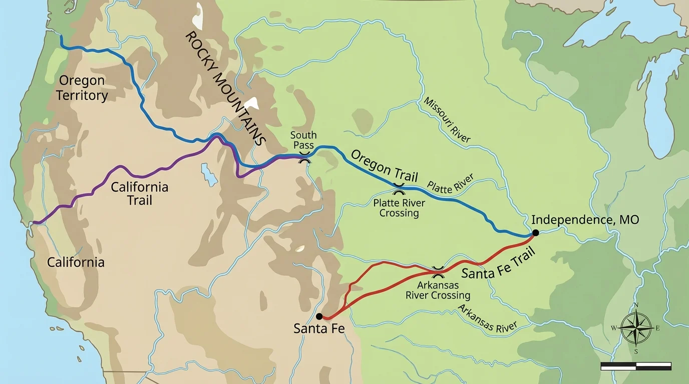
Beyond the Mississippi lay the Great Plains, a broad region of grasslands. To many Americans in the 1800s, the plains seemed wide open and full of opportunity. The geography of this region, mapped in [Figure 4], encouraged movement because the land was flatter than mountain regions. But the plains also brought dangers such as harsh weather, little shade, and long distances between water sources.
Several major trails crossed this region. The Oregon Trail carried settlers to the Pacific Northwest. The Santa Fe Trail connected Missouri to the Southwest for trade. The California Trail helped gold seekers reach the West after 1848. Geography shaped these routes because travelers needed river crossings, grass for animals, and pathways around difficult terrain.
For Native American nations, the Great Plains were already home. Westward movement by settlers changed life across the plains. Hunting grounds were disrupted, buffalo herds were reduced, and conflicts increased. Geography influenced not only where people moved, but also whose lives were changed when newcomers arrived.
The plains later became important for farming. Rich soil made large-scale agriculture possible, especially after new tools and railroad lines made settlement easier. Still, the region's climate could be difficult. Droughts, prairie fires, and strong winds challenged farmers. So the plains offered both opportunity and risk.
Some early maps labeled part of the Great Plains as the "Great American Desert" because many people thought the region was too dry for farming. Later settlers discovered that some parts were excellent for crops, especially when new farming methods and transportation systems developed.
The movement west across the plains had huge consequences. It helped the United States expand, but it also caused the forced removal and suffering of many Native peoples. Geography made the movement possible, and the movement changed the geography of human settlement across the continent.
Farther west, settlers faced the Rocky Mountains. These high mountains were another major barrier. Snow, steep slopes, and high passes made travel slow and dangerous. Just as the Appalachians affected movement in the East, the Rockies influenced routes in the West.
Even so, valuable resources drew people there. Gold and silver discoveries brought miners into mountain regions. Towns sprang up quickly near mining camps. Some lasted and became cities; others became ghost towns after resources ran out. Here again, geography affected movement because people went where the resources were.
The building of the transcontinental railroad changed the meaning of distance. Crossing the West no longer depended only on trails and wagons. Rail lines passed through difficult terrain using engineering and labor to overcome geographic barriers. This helped tie the country together, increased trade, and encouraged more migration to western lands.
California's geography also mattered. Its Pacific coast opened trade with Asia. Its valleys supported farming. During the Gold Rush, thousands moved there quickly because mountains and rivers held resources people wanted. In the Far West, geography influenced settlement, industry, and international connections.
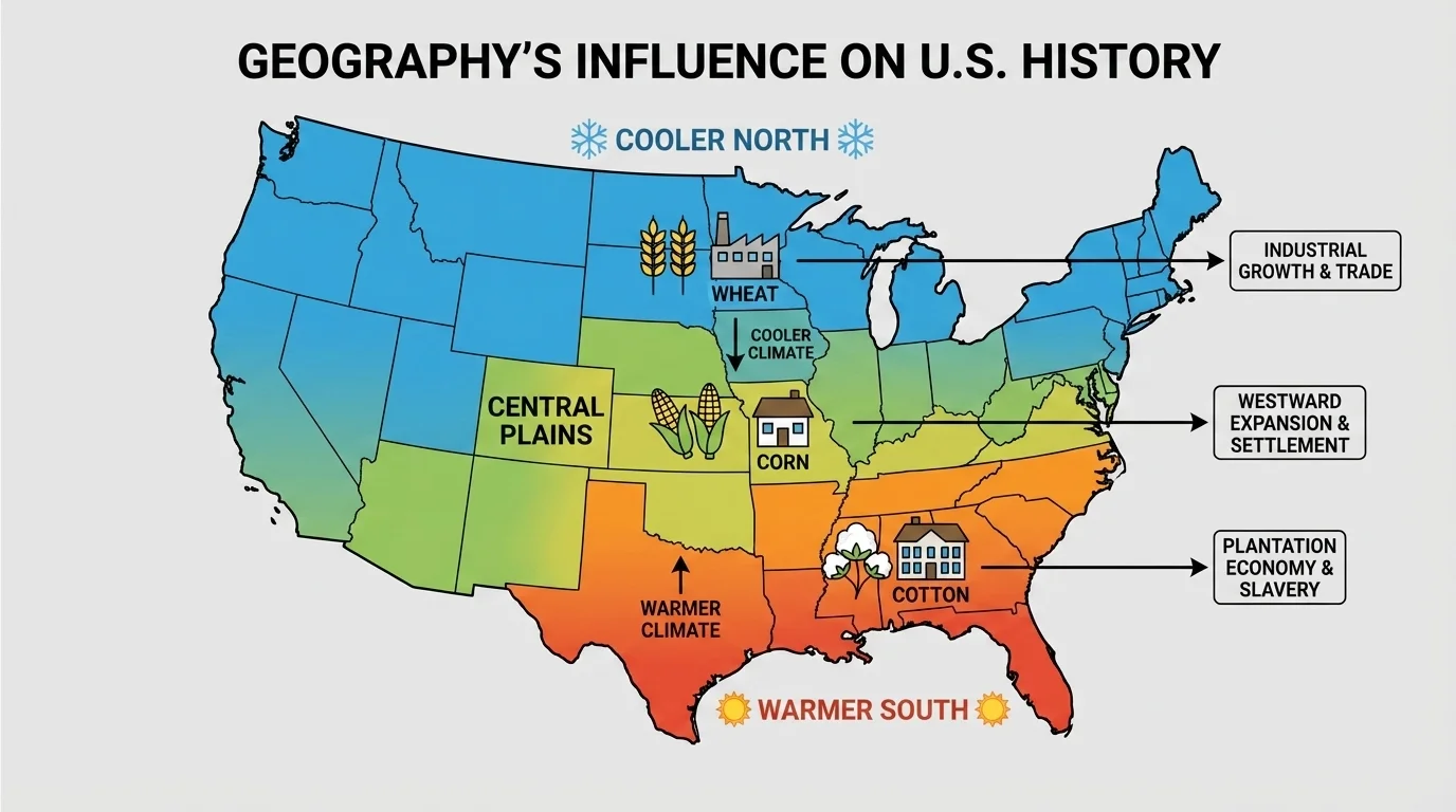
Climate and soil helped decide what people could grow across different parts of the country. In the South, warm temperatures and a long growing season supported crops such as tobacco, rice, and cotton. In the North, cooler climates and different soils often supported smaller farms and crops such as wheat, corn, and vegetables.
As [Figure 5] illustrates, these differences had major effects on history. In the South, cotton became extremely profitable after the cotton gin was invented. Large plantations expanded, and slavery grew stronger because plantation owners demanded forced labor. In the North, industry and trade became more important in many places. Geography did not cause every difference by itself, but it strongly shaped regional economies.
The Midwest later became known for rich farmland. Deep, fertile soil and enough rainfall supported crops on a large scale. This helped make the region an agricultural center. Farmers there shipped grain and livestock to other parts of the country using rivers and railroads.
| Region | Important Geographic Features | Historical Effects |
|---|---|---|
| New England | Rocky soil, forests, good harbors | Fishing, trade, shipbuilding |
| South | Warm climate, coastal plains, fertile soil | Cash crops, plantations, growth of slavery |
| Midwest | Fertile plains, rivers | Large-scale farming, trade |
| West | Mountains, minerals, valleys, Pacific coast | Mining, railroads, farming, ports |
Table 1. Geographic features in major U.S. regions and some of their historical effects.
Regional differences sometimes created conflict. Northern and Southern states developed different economies and ways of life. Those differences became part of the tension that led to the Civil War. The regional pattern shown in [Figure 5] helps us understand why different parts of the country often wanted different policies.
Geography has influenced wars in U.S. history too. During the American Revolution, the Atlantic Ocean connected the colonies to Britain but also made communication slow. Local geography mattered in battles. Mountains, forests, rivers, and roads shaped where armies could move.
During the Civil War, rivers were again important. Controlling the Mississippi River was a major Union goal because it would split the Confederacy and limit movement. The Union victory at Vicksburg in 1863 helped achieve that goal. Geography did not decide the war by itself, but it strongly affected military plans and supply routes.
"The possession of the Mississippi is the key to the whole situation."
— President Abraham Lincoln
In World War II, the oceans protected the mainland United States from invasion, but they also required ships and ports to move troops and supplies. Pearl Harbor in Hawaii showed that islands in the Pacific had strategic importance. Location matters in war just as it matters in trade and settlement.
When we study war, it is easy to focus only on leaders and battles. But geography is part of the story in every conflict. Armies must move across real land, use real roads, and cross real rivers. Distance, weather, and terrain can help or hurt each side.
The United States has long coastlines on the Atlantic and Pacific Oceans and a coast on the Gulf of Mexico. This geographic position helped the country trade with Europe, Latin America, Africa, and Asia. Coastal cities became centers of shipping, immigration, and business.
New York City is a strong example. Its excellent harbor and connection to the Hudson River and Erie Canal made it a major gateway for people and goods. Millions of immigrants entered the United States through ports such as New York. Geography helped make the city one of the nation's most important economic centers.
On the Pacific coast, cities such as San Francisco, Seattle, and Los Angeles also grew because of location. They linked the United States to the Pacific region. Trade across the ocean, access to natural resources, and movement of people all increased because these coastal places could connect land routes to sea routes.
Cause and consequence of movement
A geographic feature can be a cause of movement by attracting people or guiding them along a route. The same feature can also shape the consequence of movement by changing economies, populations, and cultures in the places people leave and the places they enter. A river may draw settlers in, and later that same river may help a town become a city.
Ports did not only move goods. They also brought languages, customs, foods, religions, and ideas. Geography therefore shaped culture as well as economics. A city connected to the sea often became more diverse because people from many places arrived there.
Many of the biggest population centers in the United States are still located near coasts, rivers, and fertile valleys. Transportation routes often follow paths first shaped by geography. Highways and rail lines commonly pass through valleys and mountain gaps because those are the easiest places to travel.
Natural resources continue to matter too. Oil, coal, timber, water, and farmland affect jobs and settlement. Weather hazards such as hurricanes, droughts, floods, and wildfires also influence where people live and how communities prepare. Geography is not just part of the past. It continues to shape choices in the present.
When you think about movement in history, remember to ask four questions: Where did people want to go? What geographic feature helped or blocked them? Why did they keep moving anyway? What changed after they arrived?
Looking at U.S. history through geography helps us understand patterns that might otherwise seem random. Cities grew where water and trade helped them grow. Migrations followed routes that the land allowed. Regional differences developed because climates and resources were not the same everywhere. Geography did not control every event, but it strongly influenced the path the nation took.