A banana picked in Ecuador may be eaten in Canada. A storm formed over warm Caribbean waters may affect islands and the coast of the United States. A river can carry water across borders, and a highway can move trucks full of goods from one country to another. These are all examples of how places are connected. Geography is not just about where things are. It is also about how places influence one another.
Every place has a location, physical features, people, and resources. But no region exists alone. Places are linked by travel, trade, migration, climate, rivers, language, culture, and technology. When geographers study connections, they look at both human actions and natural systems. In the Western Hemisphere, which includes North America, Central America, the Caribbean, and South America, these connections are especially important because regions differ so much in climate, landforms, wealth, resources, and population.
Some connections make movement easier. An ocean route can help ships carry goods. A shared language can help people communicate. Other connections create challenges. A mountain range may make travel harder. A hurricane may damage several countries in the same week. To understand geography well, students must classify the kinds of connections they see and then analyze their effects.
Region is an area that has one or more features in common, such as climate, language, history, or landforms.
Human connections are links created by people through movement, trade, communication, politics, and culture.
Geographic connections are links caused by physical features and natural systems, such as rivers, mountains, climate, and ecosystems.
Interaction is the way people and the environment affect each other.
When geographers study connected places, they often ask four main questions: What is being connected? How is it connected? Who benefits or faces problems? How does the connection change people or the environment? These questions help move beyond simple description and into analysis.
Migration, trade, communication, transportation, culture, and politics are all major human connections. Across the Western Hemisphere, people move from rural areas to cities, from one country to another, and from islands to mainlands in search of safety, jobs, education, or family support. Human connections also include the movement of products, money, music, languages, and ideas, as [Figure 1] shows through links across the hemisphere.
Migration happens when people move from one place to another. Some migration is internal, like families moving from the countryside to Mexico City or São Paulo. Some is international, like people moving from Venezuela to neighboring countries or from Central America to the United States. Migration can strengthen economies by adding workers and skills, but it can also create pressure on housing, schools, and services in destination areas.
Trade is another major human connection. Countries exchange goods because different regions produce different things. Canada exports wheat, lumber, and minerals. Brazil exports coffee and soybeans. Caribbean islands often import more manufactured goods than they produce. Trade creates jobs, but it can also increase pollution from transportation and industry.
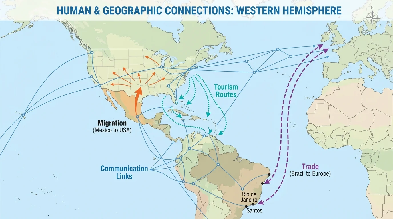
Transportation connects regions through roads, railways, ports, airports, and canals. The Panama Canal is one of the most important transportation links in the hemisphere because it allows ships to move between the Atlantic and Pacific Oceans more quickly. Border bridges, airports, and shipping ports also connect places economically and culturally.
Communication creates connections even when people do not travel physically. Phones, internet networks, television, and social media spread news, music, sports, and political ideas rapidly. A student in Peru can listen to music from Puerto Rico, watch a baseball game from the Dominican Republic, or speak online with family in the United States.
Culture connects places through language, religion, food, celebrations, and traditions. Spanish is spoken in much of Latin America, while Portuguese connects Brazil internally and internationally. Indigenous traditions also connect communities across borders, reminding us that cultural regions do not always match political borders.
Human connections can be positive, negative, or mixed. For example, tourism brings money to Caribbean islands, but too much tourism can strain water supplies, create waste, and damage coral reefs. Later in the lesson, we return to the patterns in [Figure 1] to see that the same route can carry both benefits and problems.
The Panama Canal saves ships thousands of miles of travel because they do not have to sail all the way around the southern tip of South America. That makes trade faster and often cheaper.
Governments also create human connections. Countries sign trade agreements, share border rules, and sometimes cooperate on disaster response. At other times, governments disagree about migration, tariffs, fishing rights, or the use of water from shared rivers.
Landforms, climate, water systems, natural resources, ecosystems, and natural hazards connect places in powerful ways. Physical geography is not just background scenery. It shapes how people live, where they settle, what they grow, and how they travel. In the Western Hemisphere, these natural links can connect distant regions, as [Figure 2] illustrates, or separate nearby places.
Rivers connect regions by moving water, soil, people, and goods. The Mississippi River system connects farms, cities, and ports in the United States. The Amazon River connects many communities in South America and supports transportation in areas where roads are limited. Shared rivers can help farming and trade, but they can also lead to conflict over water use.
Mountains can both connect and divide. The Andes Mountains run along western South America and influence climate, farming, settlement, and transportation. Mountains may protect an area or provide minerals, but they also make road building and travel more difficult.
Climate zones help explain why some places grow tropical fruits while others produce wheat or raise cattle. Warm, wet climates in parts of Central America and the Amazon support rainforests. Drier regions in northern Mexico need irrigation for farming. Climate influences homes, clothing, work schedules, and even the kinds of hazards people face.
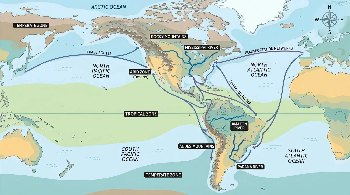
Oceans and seas connect coastal regions through shipping and fishing. The Atlantic Ocean, Pacific Ocean, Caribbean Sea, and Gulf of Mexico all shape the economy and weather of nearby lands. Coastal cities often become important trade centers because ships can move large amounts of goods.
Natural resources create geographic and economic connections. Oil from Venezuela and Canada, copper from Chile, forests in Canada and the Amazon, and fertile soil in the Great Plains all connect regions through resource use and trade. But heavy use of resources can lead to deforestation, water pollution, and habitat loss.
Ecosystems also cross borders. Birds migrate between Canada, the United States, the Caribbean, and South America. Ocean currents affect fish populations in more than one country. What happens in one ecosystem may affect people far away.
Natural hazards are another geographic connection. Hurricanes, earthquakes, volcanic eruptions, droughts, and floods do not stop at political borders. A hurricane in the Caribbean can affect tourism, farming, transportation, and homes in several countries at once. This is one reason countries often work together during emergencies.
The Western Hemisphere has great regional diversity. Some places are highly industrialized and wealthy. Others depend more on farming, fishing, mining, or tourism. Some regions are urban, with large cities and dense populations. Others are rural, with smaller settlements spread across mountains, forests, or plains. These differences shape both human and environmental interactions.
For example, colder parts of Canada have a low population density because long winters and harsh conditions make settlement harder. In contrast, many people live in warmer coastal areas and southern cities. In the Caribbean, islands depend strongly on sea connections because water surrounds them. In the Andes, people adapt to high elevations by farming crops suited to mountain climates. In the Amazon Basin, dense rainforest and river systems shape transportation and land use.
Regional differences also affect environmental decisions. A place with abundant water may use it differently from a dry region. A country with a strong manufacturing economy may produce more industrial pollution than a country focused on farming. A small island may be more vulnerable to sea-level rise and hurricanes than an inland plateau.
| Region | Important Features | Common Connections | Possible Challenges |
|---|---|---|---|
| Canada and northern North America | Cold climate, forests, minerals | Trade, energy, shipping | Harsh winters, remote settlements |
| United States and Mexico borderlands | Deserts, rivers, cities, industry | Migration, trade, transportation | Water use, border control, pollution |
| Caribbean | Islands, warm seas, tourism | Shipping, tourism, fishing | Hurricanes, limited land, import dependence |
| Amazon Basin | Rainforest, large river system, biodiversity | River transport, resource use, environmental cooperation | Deforestation, habitat loss, access challenges |
| Andes region | High mountains, minerals, varied climates | Mining, farming, cultural exchange | Difficult travel, earthquakes, steep terrain |
Table 1. Regional features, common connections, and challenges in parts of the Western Hemisphere.
Regional differences change interactions
When regions differ in climate, resources, population, or wealth, they often become connected through exchange. One region may sell food, another may provide manufactured goods, and another may depend on tourism. These differences can create opportunity, but they can also create inequality and environmental stress.
Looking at regional differences helps geographers explain why people make certain choices. A farmer in a dry region may focus on irrigation. A city near a major port may develop factories and warehouses. An island nation may invest heavily in tourism because beaches and warm weather attract visitors.
The deforestation of the Amazon matters far beyond one country. The Amazon Basin stretches across several South American countries and is linked by a huge river system, rich biodiversity, Indigenous communities, farming zones, and global climate importance. This shared region is a strong example of human and geographic connections working together, as [Figure 3] shows.
Geographically, the Amazon is connected by rainforest, rivers, rainfall patterns, and wildlife habitats. Human connections include river travel, logging, mining, cattle ranching, farming, and government policies. Cities and villages depend on the river for transportation. Companies depend on land and resources. Indigenous groups depend on the forest for culture, food, and shelter.
These connections can create conflict. Cutting trees may provide farmland and jobs, but it can also destroy habitats, increase soil erosion, and reduce biodiversity. Smoke from fires can affect air quality. Changes in one part of the forest can influence water cycles in other places. Because the Amazon is so large, decisions made in one area may affect people who live far away.
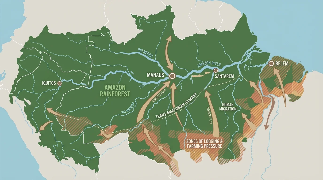
Different groups see the region differently. A logging company may focus on economic gain. Indigenous communities may focus on protecting land and traditions. Environmental scientists may focus on biodiversity and climate. Governments may try to balance development with conservation. This is why perspective is important in geographic analysis.
The river network in [Figure 3] helps explain why river transport is so important there. In many rainforest areas, dense vegetation and seasonal conditions make road building difficult, so rivers serve as highways.
Case study analysis: classifying Amazon connections
Step 1: Identify the connection.
People use the Amazon River to move goods and people.
Step 2: Classify the type.
This is both a human connection because people are transporting goods, and a geographic connection because the river physically links settlements.
Step 3: Analyze effects.
The river helps trade and travel, but increased development may also lead to pollution and habitat loss.
This example shows that one connection can fit more than one category.
The Amazon teaches an important lesson: a region can be rich in resources and still be fragile. Strong connections make cooperation necessary because the environment does not follow political borders.
The Caribbean and Gulf of Mexico form a region tied together by warm water, trade routes, fishing grounds, tourism, and storms. Islands and coastal lands depend on the sea for food, transportation, and jobs. Cruise ships, cargo ships, and airplanes bring visitors and products from many countries.
This region shows how one natural feature can create many types of connection. Warm seas support tourism, but they also help hurricanes grow stronger. A hurricane can damage ports, homes, farms, coral reefs, and beaches in several places in a short time. After a storm, nearby countries may send aid, workers, or supplies.
Tourism is especially important in many Caribbean places. Beaches, coral reefs, and tropical weather attract visitors from North and South America. But heavy tourism can raise prices, increase waste, and put pressure on fresh water. Coral reefs may be harmed by pollution, overfishing, or careless boating.
Fishing also links the region. Fish move through shared waters, so countries sometimes need agreements about fishing areas and catch limits. If one area overfishes, the effect may spread across the whole region.
Political borders are human-made lines, but winds, water, storms, and migrating animals do not follow those lines. That is why neighboring countries often share environmental problems.
This region makes it clear that environmental interactions can affect human life quickly. A change in sea temperature can influence storms, fishing, and tourism all at once.
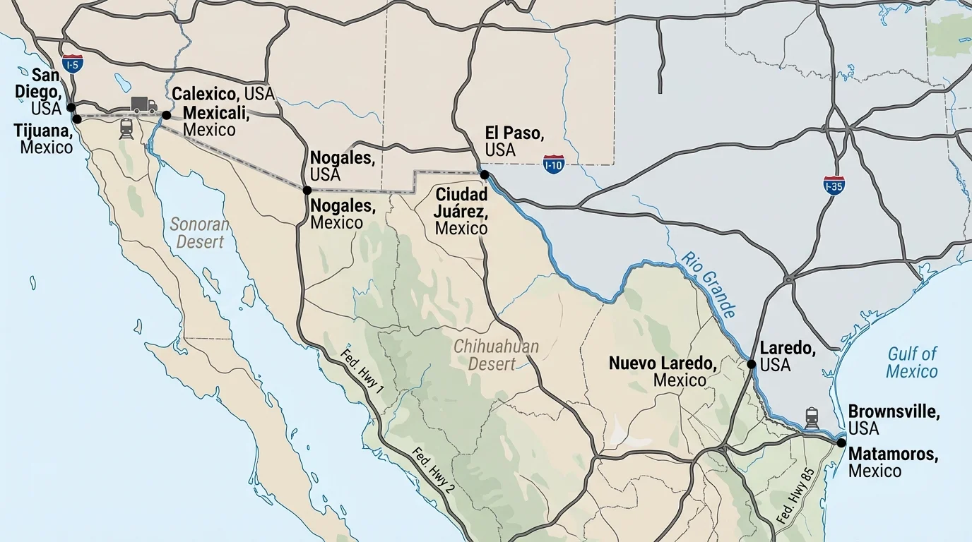
The border between the United States and Mexico is a political boundary, but it is also a zone of strong connection. Cities, roads, factories, farms, and shared water systems link the region every day, as [Figure 4] illustrates. People cross legally for work, school, shopping, and family visits. Goods move through border crossings by truck and rail.
Trade is one major connection here. Products may be designed in one country, assembled in another, and sold in both. This creates jobs and economic growth. Border cities often grow rapidly because they are centers of transportation and manufacturing.
Migration is another connection. Some people move temporarily for seasonal work, while others move permanently. Migration can enrich culture and support families through money sent home, but it can also lead to debates about laws, borders, and services.
Water is a key geographic connection. Rivers such as the Rio Grande help define parts of the border and supply water to farms and cities. In dry areas, water is limited, so people must cooperate about how much is used and how it is protected from pollution.
Environmental issues also cross the border. Air pollution from traffic and factories, water pollution, and habitat loss can affect communities on both sides. This shows that environmental problems often require shared solutions.
Culture is deeply connected in the borderlands. Food, music, language, festivals, and family traditions blend across the region. The transportation routes shown in [Figure 4] help explain why cultural exchange is so strong: frequent movement increases daily contact.
Case study analysis: classifying border-region connections
Step 1: Observe the connection.
Trucks carry car parts across the border for assembly and sale.
Step 2: Classify it.
This is a human connection based on trade and transportation.
Step 3: Add the geographic factor.
The dry climate and limited river water influence where factories and cities can grow.
Step 4: Analyze perspectives.
Business owners may value economic growth, while local residents may worry about traffic, air pollution, or water use.
Good geographic analysis includes both the benefits and the challenges.
The border region is a powerful example of how one area can be connected economically, culturally, politically, and environmentally all at the same time.
When you study a place, start by asking what kind of connection you notice. Is it mainly human, mainly geographic, or both? Then ask what causes it. A shared language may create a cultural link. A river may create a transportation link. A mountain barrier may limit movement and cause settlements to form in valleys.
Next, analyze the effects. Does the connection increase trade, improve travel, spread ideas, or bring people together? Does it also create pollution, resource pressure, or conflict? Geographers often find that the same connection has both positive and negative effects.
Finally, consider scale. Some connections are local, such as travel between two nearby towns. Others are regional, such as trade among Caribbean islands. Still others are global, such as the sale of coffee grown in Colombia to people in many countries.
A simple method for analysis
You can analyze a connection by using four labels: type, cause, effect, and perspective. This method helps you move from naming a connection to explaining why it matters.
For example, if a port city imports products from many countries, the type is trade and transportation. The cause may be a good coastal location. The effects may include jobs and air pollution. Perspectives may differ between business leaders, residents, and environmental groups.
Two people can look at the same geographic connection and reach different conclusions. That does not always mean one person is wrong. It may mean they have different goals or experiences. A farmer may want more irrigation water. A city may need that same water for homes and businesses. An environmental group may want more water left in the river for wildlife.
Perspective is especially important in regions where resources are limited or where change happens quickly. In the Amazon, views differ about forest use. In the Caribbean, views differ about tourism growth. In the borderlands, views differ about migration and trade. Geographic study becomes stronger when students notice these different points of view.
"Geography is the study of places and the relationships between people and their environments."
— A core idea of geography
Understanding perspective also helps students become careful thinkers. Instead of asking only, "What is happening?" geographers ask, "Who is affected, and how?"
Maps help us see patterns that words alone may hide. A physical map shows mountains, rivers, and elevation. A political map shows borders and capitals. A population map shows where many people live. A climate map shows temperature and rainfall patterns. Each kind of map reveals a different connection.
Geographic data can also help us compare regions. If one area has more rainfall, it may grow different crops. If another has a major port, it may have stronger trade links. If a region lies in a hurricane path, it may need stronger building plans and emergency systems.
Good geographic thinking combines map reading with careful questions. What does the map show? What does it not show? How do human actions and physical features work together? These questions help students classify connections clearly and analyze them with evidence.