A city can rise in a desert, crops can grow on the side of a mountain, and ships can cross a narrow strip of land through a canal. These things happen because humans constantly interact with the physical world around them. In the Western Hemisphere, from the Arctic parts of North America to the rainforests of South America, people depend on land, water, climate, and natural resources. At the same time, people also change those places. Sometimes the results help both people and the environment. Sometimes they create serious problems.
A system is a group of parts that work together. In geography, human systems include cities, transportation networks, farms, trade, governments, and the ways people organize their lives. Physical systems include landforms, rivers, oceans, climate, plants, animals, and natural processes such as erosion, storms, and earthquakes.
When human systems and physical systems meet, they affect each other. A river may make a good place for a city because it provides water and transportation. But building a city along that river can also increase pollution or change the river's flow. Understanding this two-way relationship helps us explain why people live where they do and why some places face environmental challenges.
Human systems are the ways people build communities and organize life, including transportation, trade, farming, and settlement.
Physical systems are the natural features and processes of Earth, such as mountains, rivers, climate, soil, forests, and storms.
Interaction means that people and the environment affect one another.
Geographers study these interactions across regions. A region is an area with shared features. The Western Hemisphere includes very different regions, and those differences matter. Life in the Canadian Arctic is not the same as life in the Amazon Basin. Farming on the Great Plains is not the same as farming in the Andes Mountains.
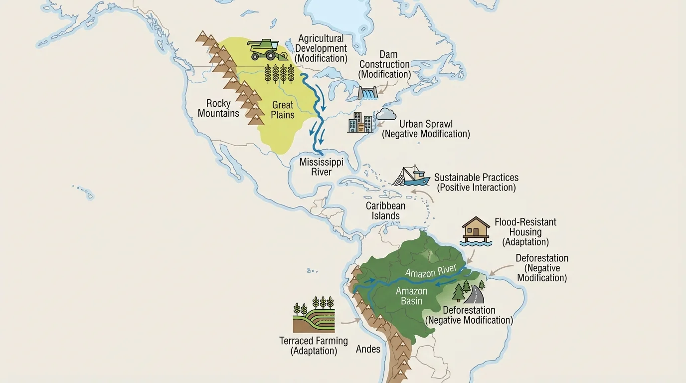
Regional differences shape human choices, as [Figure 1] shows through the Western Hemisphere's mountains, rivers, plains, and islands. The hemisphere includes the Rocky Mountains, the Andes, the Great Plains, the Amazon rainforest, the Mississippi River system, the Caribbean islands, dry deserts in the southwestern United States and northern Mexico, and cold northern lands in Canada and Greenland.
These physical features influence where people settle, what jobs they do, what crops they grow, and how they travel. Flat plains often support farming and transportation. Mountain regions can be beautiful and rich in minerals, but they may be harder to cross and harder to farm. Tropical regions may have rich biodiversity and heavy rainfall, while dry regions require careful water use.
Climate also changes from region to region. Some places have long, cold winters. Others are warm and wet most of the year. Coastal regions may depend on fishing and shipping, while inland regions may depend more on farming, ranching, or mining. Because of these differences, people in different regions often develop different lifestyles, technologies, and solutions.
Natural hazards are also unevenly spread. The Caribbean faces hurricanes. Parts of the Pacific coast of North and South America face earthquakes and volcanoes. River valleys may flood. Dry grasslands may experience drought. Regional geography does not just influence daily life; it also affects danger, risk, and planning.
The Andes Mountains in South America are the longest continental mountain range in the world. People have lived there for thousands of years by adapting to steep slopes, thin air, and changing temperatures.
Because physical systems vary so much, human-environment interaction also varies. The same action may help in one region and cause harm in another. Building a dam might provide electricity and water storage in one place, but in another place it might flood farmland or disrupt fish habitats.
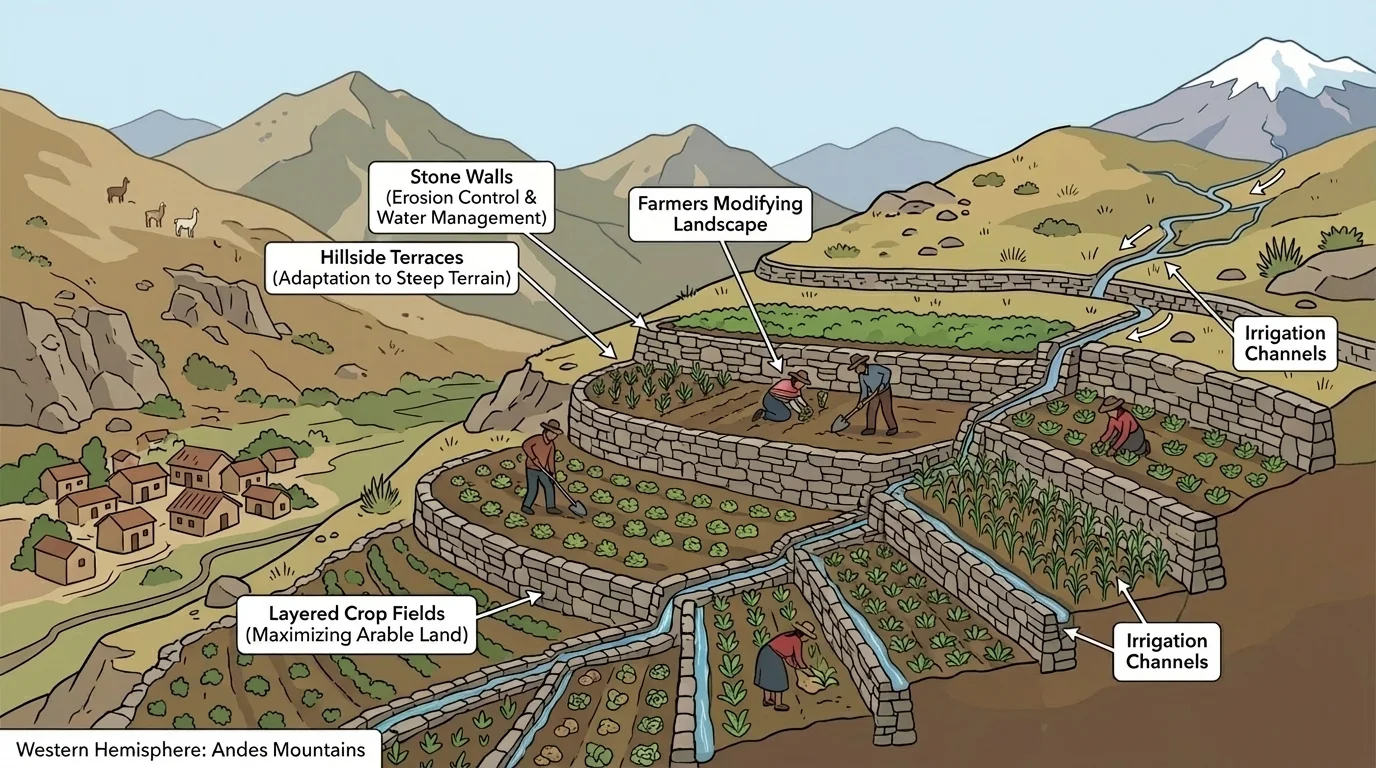
Not all human impact is harmful. In many places, people find ways to live with the environment wisely, and [Figure 2] illustrates one strong example in mountain regions. Positive interactions happen when people use resources carefully, protect ecosystems, or adapt in ways that reduce damage.
One example is terracing in the Andes. Farmers cut flat steps into steep mountain slopes. These terraces create space to grow crops and help slow erosion. Instead of rainwater rushing downhill and washing away soil, the terraces help hold the soil in place. This is both an adaptation to the mountains and a modification of the environment.
Another positive interaction is conservation. In parts of North and South America, forests, wetlands, and grasslands are protected in parks or reserves. These protected areas can preserve habitats, keep water cleaner, and support tourism. Ecotourism, when managed carefully, can give local communities income while encouraging protection of wildlife and landscapes.
Renewable energy can also be a positive interaction. In some areas, people use moving water, wind, or sunlight to produce energy. Hydroelectric dams in places such as Canada and Brazil can provide large amounts of electricity without burning fossil fuels. However, even positive changes require careful planning, because they can still affect rivers, fish, and nearby communities.
Indigenous peoples across the Western Hemisphere have long used deep environmental knowledge. Some Native American groups in dry areas planted crops in ways that saved water. In rainforest regions, many Indigenous communities used plants, soils, and seasonal patterns carefully to avoid exhausting the land. These practices remind us that positive interaction often depends on understanding a place over a long period of time.
Positive interaction does not mean no change. Sometimes people improve their lives by changing the environment in limited, thoughtful ways. The goal is to meet human needs while keeping soil, water, forests, and wildlife healthy enough to support future generations.
As we saw with mountain terraces in [Figure 2], the best solutions often fit the local environment. A method that works on steep slopes may not be useful on open grasslands, and a water-saving idea from a dry region may be less important in a rainforest.
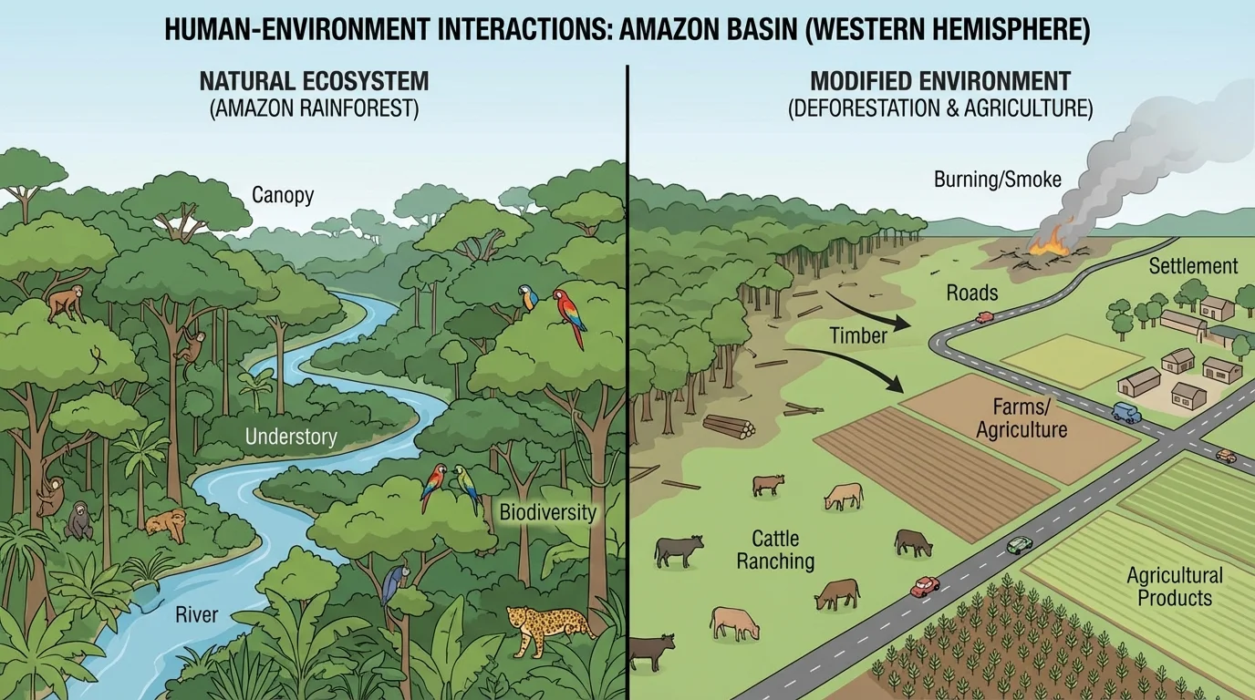
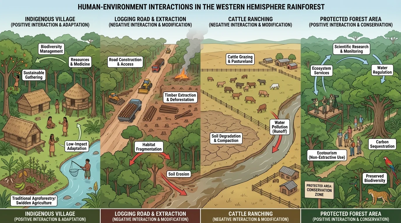
Human-environment interaction can also cause major problems, and [Figure 3] presents one of the clearest examples in the Amazon. Negative interactions happen when people overuse resources, pollute air or water, destroy habitats, or increase the danger from natural hazards.
Deforestation is a major issue in parts of the Amazon rainforest. Trees may be cut down for farming, ranching, roads, or logging. When forests are cleared too quickly, soil can lose nutrients, animals can lose habitats, and large amounts of carbon can enter the atmosphere. Forest loss can also change local rainfall patterns.
Pollution is another harmful interaction. Factories, farms, and cities can release waste into rivers, lakes, and the ocean. Oil spills damage coastlines and marine life. Fertilizers from farms can wash into water systems and harm fish. In busy cities, cars and industries can pollute the air, leading to health problems.
Overfishing affects some coastal regions and island communities. If fish are caught faster than they can reproduce, fish populations decline. This hurts marine ecosystems and also harms people who depend on fishing for food or income. In the Caribbean and along the Pacific and Atlantic coasts, healthy oceans are closely tied to human well-being.
Urban growth can create problems too. When cities spread into wetlands, forests, or flood-prone areas, the environment changes and people may face greater risk. Paved surfaces such as roads and parking lots prevent water from soaking into the ground. This can increase flooding after heavy rain.
Case study: Amazon rainforest
Step 1: Roads are built into forested areas.
Step 2: Logging, ranching, or farming expands along those roads.
Step 3: Trees are removed, habitats shrink, and soil becomes more exposed.
Step 4: Local communities, wildlife, climate patterns, and water systems are affected.
This example shows how one change can trigger many connected effects.
The contrast in [Figure 3] makes an important point: one region can provide resources for people and still need protection. Geography often involves trade-offs, which means gaining one benefit may also bring one cost.
Adaptation means adjusting to environmental conditions. People adapt in many ways depending on where they live. In cold northern parts of Canada and Greenland, homes, clothing, and travel methods are designed for snow, ice, and freezing temperatures. In hot climates, buildings may use shade, airflow, and light-colored materials to stay cooler.
People in mountain regions adapt by building roads that curve along slopes, growing crops suited to high elevations, and creating homes that handle steep terrain. In flood-prone regions, some homes are built on stilts to keep living spaces above high water. In hurricane regions, stronger roofs, storm shutters, and emergency plans help communities prepare.
Farmers also adapt to climate and soil. On the Great Plains, large farms often grow grains that match the region's grassland environment. In dry parts of the western United States and northern Mexico, farmers may rely on irrigation to bring water to crops. In tropical lowlands, farmers choose crops that can handle heat and heavy rainfall.
People do not live separately from nature. Every settlement depends on water, land, climate, and resources. Geography asks not only where people live, but also why they live there and how they respond to local conditions.
Adaptation is often about survival, but it can also be about comfort, efficiency, and culture. A building style that developed over many generations may reflect the climate of a place. Food traditions also show adaptation because people often cook what grows well in their region.
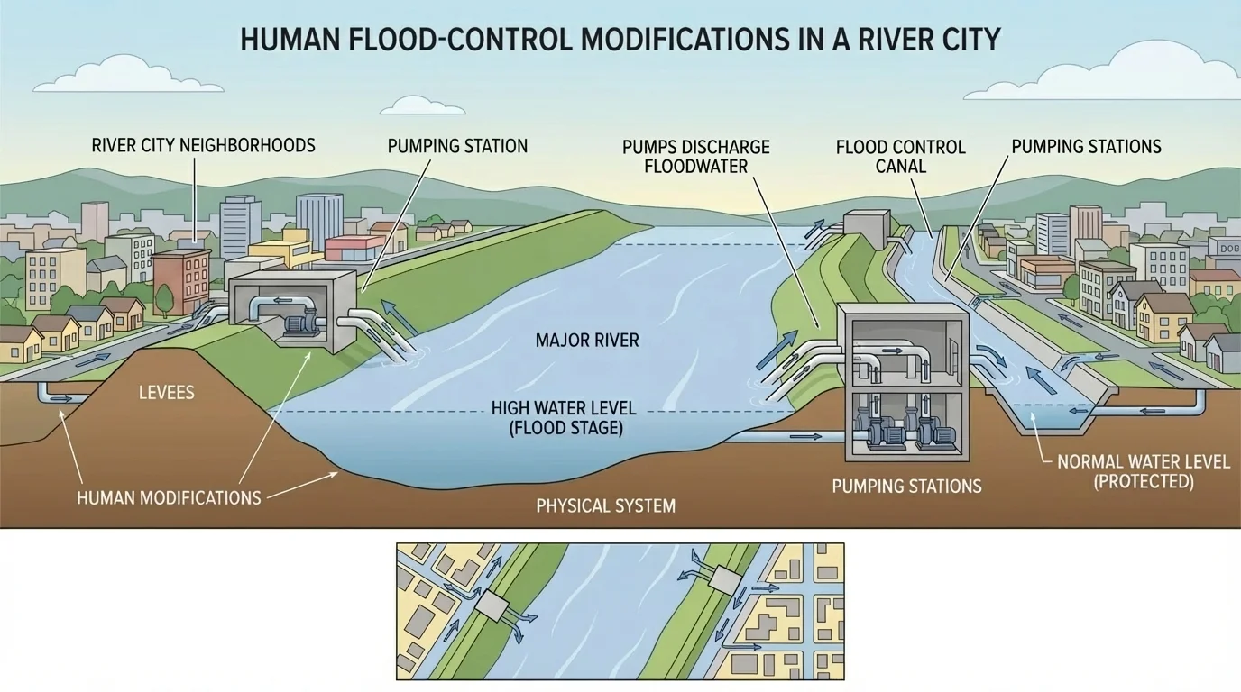
People do more than adapt. They also modify the environment to fit their needs. [Figure 4] shows how engineering can reshape a river landscape. Modification includes building dams, canals, levees, roads, tunnels, ports, and irrigation systems.
One major example is the Panama Canal in Central America. Humans cut through land to connect the Atlantic and Pacific Oceans. This dramatically changed global shipping because ships no longer had to travel around the southern tip of South America. The canal helped trade and transportation, but it also changed local landscapes and water systems.
Another example is flood control. In places such as New Orleans, engineers built levees, canals, and pumps to protect communities from flooding. These structures help people live in low-lying areas near water, as shown in [Figure 4]. However, if the systems fail during a major storm, the danger can be severe.
Dams are another powerful modification. They can create reservoirs for drinking water, irrigation, and electricity. But dams may also flood valleys, force people to move, and disrupt fish migration. Human choices often solve one problem while creating another.
Large-scale farming can modify land by clearing forests, draining wetlands, or planting a single crop over a huge area. This can increase food production, but it may reduce biodiversity and damage soil over time. A useful geographic question is not just "Can people change a place?" but "What happens next?"
| Human action | Possible benefit | Possible cost |
|---|---|---|
| Dams | Electricity, water storage | Habitat loss, flooding of land |
| Levees | Flood protection | Risk if levees fail, altered wetlands |
| Irrigation | More farmland in dry areas | Water shortages, soil problems |
| Road building | Faster travel and trade | Habitat fragmentation, erosion |
| Forest clearing | More space for farming or building | Deforestation, carbon release |
Table 1. Examples of ways people modify the environment and some benefits and costs of each action.
Later, when we compare viewpoints, [Figure 4] remains useful because the same flood-control project can look successful to one group and risky to another. That is why geography includes both environmental facts and human perspectives.
Specific places help us see these ideas more clearly. In the Andes, terraces allow farming on steep slopes. This shows adaptation and modification working together. In the Amazon, deforestation shows how resource use can become harmful when it happens too quickly or over too large an area.
In the Great Plains of North America, farmers have used irrigation and machinery to grow crops across wide grasslands. This has helped feed many people, but overuse of water can lower groundwater supplies. In dry regions, saving water becomes a major issue.
In the Caribbean, communities prepare for hurricanes by improving building codes, planning evacuations, and protecting mangroves and coral reefs. Mangroves can help reduce wave energy along coasts. This is a good example of using nature itself as part of protection.
In coastal cities and river cities, flood-control projects can make settlement possible in risky places. Yet strong storms remind people that engineering cannot remove all danger. The environment continues to shape human life even after people try to reshape it.
Case study: Caribbean hurricane adaptation
Step 1: Weather experts track storms over warm ocean water.
Step 2: Communities prepare shelters, warnings, and evacuation routes.
Step 3: Stronger buildings and protected coastal ecosystems reduce damage.
Step 4: Recovery plans help people rebuild after the storm.
This case shows that adaptation includes both technology and planning.
These case studies show that geography is rarely simple. The same river can be a route for trade, a source of water, a flood risk, and an ecosystem for fish and birds. A forest can be a home, a resource, a carbon store, and a place of spiritual importance.
People do not all see the same place in the same way. A farmer may see fertile land. A mining company may see valuable minerals. An Indigenous community may see an ancestral homeland. An environmental group may see fragile biodiversity that needs protection.
[Figure 5] These perspectives affect decisions. For example, one group may support building a road because it improves trade and travel. Another group may oppose the road because it cuts through a forest and opens the area to deforestation. Neither geography nor decision-making is only about maps; it is also about values, needs, and long-term effects.
Regional differences matter here too. In a wealthy city, leaders may have money for flood walls and advanced warning systems. In a poorer rural region, people may depend more on local knowledge, community cooperation, and lower-cost solutions. The physical environment may be similar, but the human response can be very different.
Looking back at the map in [Figure 1], we can see why there is no single answer for every region of the Western Hemisphere. Mountain societies, island communities, rainforest villages, prairie farms, and major coastal cities all face different choices because their physical systems are different.
"Geography is not just about places. It is about the relationships between people, places, and environments."
When students analyze interactions, they should ask several questions: Who benefits? Who may be harmed? How long will the effects last? Is the environment being used in a way that can continue into the future? Those questions help us move beyond a simple label of "good" or "bad."
A key idea in geography is sustainability. This means using resources in ways that meet human needs today without ruining the ability of future generations to meet their needs. Sustainability is especially important in the Western Hemisphere because its regions include both valuable resources and fragile environments.
Balanced decisions often combine adaptation, protection, and careful modification. A community might build stronger homes, restore wetlands, and create evacuation plans instead of relying on only one solution. Farmers might use irrigation but also conserve water and protect soil. Cities might expand transportation while reducing pollution.
The best geographic thinking recognizes that humans are part of the environment, not separate from it. We need rivers, forests, soil, oceans, and stable climates. At the same time, our actions can protect these systems or damage them. Every region of the Western Hemisphere tells that story in a different way.