A mountain range can protect a country, block trade, slow migration, and still become a famous route for cultural exchange. That sounds like a contradiction, but geography is full of them. In the Eastern Hemisphere, the same feature that separates people can also shape the limited paths where people meet. Understanding that idea helps explain why regions develop different cultures, economies, and environmental challenges.
Geographers study how physical features and political features influence human life. Physical features are natural parts of Earth such as mountains, rivers, deserts, plains, and seas. Political features are human-made divisions such as countries, borders, capitals, and trade agreements. Together, these features affect where people settle, what crops they grow, how they travel, and whom they trade with.
Place matters because people do not live on a blank map. A farmer in the Nile River valley faces different opportunities than a merchant in Singapore or a herder near the edge of the Sahara. Climate, access to water, nearby neighbors, and government rules all help shape daily life. Over time, these conditions create regional patterns that make one area different from another.
Cultural diffusion is the spread of ideas, beliefs, technologies, languages, foods, or customs from one group of people to another. A region is an area with shared characteristics, such as climate, language, religion, or economic activity.
When cultures meet, they do not simply replace one another. Often they mix. A food, religion, or invention may begin in one place and then change as it moves. That is why regional differences and cultural diffusion happen at the same time. Regions keep some unique traits, but they also borrow from one another.
Natural landforms often guide the movement of people and ideas, as [Figure 1] shows through major barriers and routes in the Eastern Hemisphere. Mountains can slow travel, deserts can reduce settlement, and seas can both connect and divide societies depending on the technology people have. Geography does not fully control history, but it strongly influences the paths that interaction follows.
The Himalayan Mountains are a good example. They form a huge barrier between South Asia and much of the rest of Asia. Because crossing them is difficult, the Himalayas helped protect parts of the Indian subcontinent from easy invasion and helped regional cultures develop in distinctive ways. At the same time, passes through the mountains allowed limited movement of traders, travelers, and religious ideas.
Deserts also shape diffusion. The Sahara Desert in North Africa is vast and harsh, so it separates many groups. Yet it did not stop contact completely. Camel caravans crossed trade routes carrying salt, gold, textiles, and ideas. In this way, a difficult physical barrier reduced contact but also created special routes where exchange became especially important.
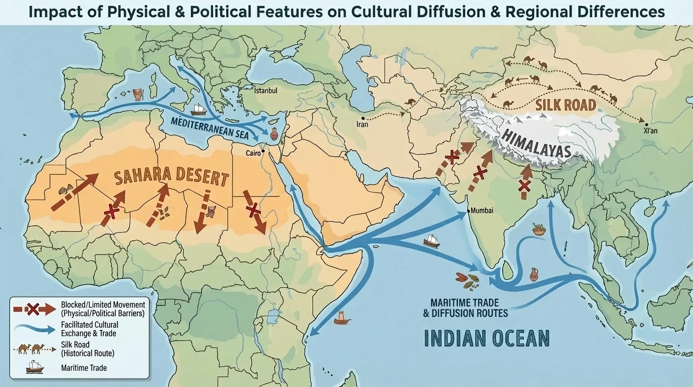
Water features can work in the opposite way. Rivers and seas often connect places. The Mediterranean Sea linked parts of Europe, North Africa, and Southwest Asia. Ports became centers of trade and learning. The Indian Ocean connected East Africa, the Arabian Peninsula, India, and Southeast Asia through monsoon wind patterns. Sailors timed journeys with seasonal winds, and this helped spread goods such as spices, fabrics, and metals as well as religions like Islam and Buddhism.
Physical geography also affects agriculture, which influences culture. Monsoon rains in South Asia support farming, especially rice cultivation in many places. Reliable seasonal rains can support dense populations, large cities, and long-lasting traditions tied to planting and harvest cycles. In contrast, dry climates may support nomadic herding or irrigation farming, creating different ways of life.
The Silk Road was not one single road. It was a network of routes across Asia that connected China, Central Asia, Southwest Asia, and Europe, spreading silk, paper, religions, and inventions.
Even when physical features create separation, they can increase the importance of certain crossroads. This is why places near mountain passes, river valleys, and sea straits often become culturally diverse. The pattern visible in [Figure 1] helps explain why some locations become meeting points instead of isolated edges.
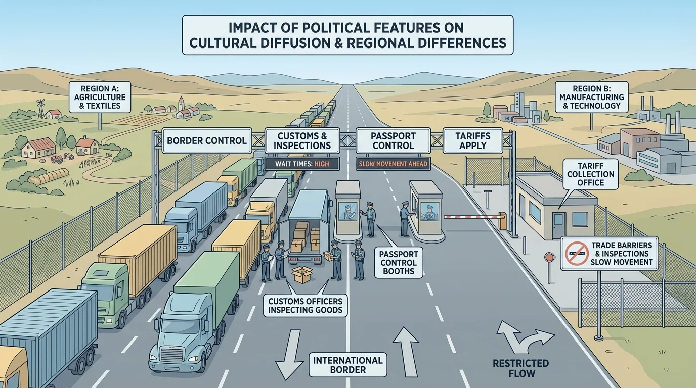
Natural geography matters, but human decisions matter too. Borders, governments, laws, and treaties can shape movement just as strongly as mountains or oceans, as [Figure 2] illustrates with a controlled border crossing. Two countries may share a flat plain that is easy to cross physically, but strict border rules can still limit migration and trade.
Political boundaries can encourage or discourage cultural diffusion. If neighboring countries cooperate, people may cross for work, study, tourism, or business. If relations are tense, the same border may become heavily guarded. Ideas and goods may move more slowly, and regional differences may become sharper.
Governments also use policies called trade barriers to control imported and exported goods. A tariff is a tax on imported goods. Quotas limit how much of a product can enter a country. Sanctions restrict trade for political reasons. These decisions affect prices, jobs, and the availability of products.
Political features can influence culture in less obvious ways too. Language laws, school systems, official religions, and immigration rules can all shape what becomes common in a region. For example, colonial history affected language patterns in parts of Africa and Asia. Today, official languages, legal systems, and national identities still reflect those political histories.
Conflict can also reduce exchange. War may damage roads, close ports, or force people to flee. On the other hand, political cooperation can create shared markets and transportation systems. In Europe, many countries have strengthened trade and travel links through regional cooperation, which has increased economic and cultural connections.
How political choices reshape geography
A border on a map may look like a simple line, but in real life it changes travel time, costs, identity, and safety. Governments decide who may enter, what goods may pass, and how resources are shared. Because of this, political geography can make nearby places feel either closely connected or sharply divided.
The lesson from [Figure 2] is that movement depends on both land and rules. Geography sets possibilities, but governments often decide how open or closed those possibilities will be.
The Eastern Hemisphere includes many large regions, each shaped by different combinations of climate, resources, and political history. These differences help explain why cultures vary from place to place.
In Southwest Asia and North Africa, dry climates and limited freshwater have made water management extremely important. Rivers such as the Nile support dense populations, while oil and natural gas have made some countries central to global energy markets. Religion has also strongly influenced culture, especially the spread of Islam across this broad region.
In South Asia, monsoon climates, fertile river plains, and mountain barriers helped create both strong regional traditions and powerful trade connections. Hinduism and Buddhism began in this region, while later exchanges brought Islam, new foods, and global trade links.
In East Asia, river valleys, coastlines, and mountain areas created a mixture of farming regions, industrial centers, and heavily populated cities. China, Japan, and Korea developed distinct cultures, but they also exchanged writing systems, technologies, religious ideas, and artistic styles over time.
In Europe, many navigable rivers, peninsulas, and access to seas encouraged trade and contact. Europe contains many countries in a relatively small area, so political borders are numerous, but trade networks are dense. This combination has created both strong local identities and broad regional cooperation.
In Sub-Saharan Africa, climate zones range from rainforest to savanna to desert edge. Trade routes, migration, colonial borders, and language diversity all contribute to major regional differences. Some borders were drawn during colonial rule without matching cultural groups, which has shaped political challenges in the modern era.
| Region | Important Physical Features | Common Effects on Human Life |
|---|---|---|
| Southwest Asia and North Africa | Deserts, limited rivers, oil fields | Water scarcity, energy trade, concentrated settlement near water |
| South Asia | Himalayas, monsoon climate, river plains | Dense farming populations, seasonal planning, regional protection and connection |
| East Asia | Rivers, coasts, mountains | Urban growth, farming zones, maritime trade |
| Europe | Rivers, plains, peninsulas, seas | Trade, travel, many nearby countries, close economic links |
| Sub-Saharan Africa | Savannas, rainforests, deserts, mineral resources | Diverse livelihoods, transportation challenges, resource-based economies |
Table 1. Major regional differences in the Eastern Hemisphere and their effects on human activities.
Environmental challenges are not spread evenly across the world, as [Figure 3] shows in different parts of the Eastern Hemisphere. Regional geography affects which problems are most serious. A country facing drought may focus on water conservation, while another facing floods may invest in levees, drainage, and warning systems.
Water scarcity is a major issue in Southwest Asia and North Africa. Populations are growing, but freshwater supplies are limited. Rivers may cross borders, so political disagreements over dams and water use can become regional issues. In dry regions, environmental stress can increase competition over resources.
Air pollution is a major concern in some industrial regions of East and South Asia. Large cities, factories, and vehicle traffic can create smog that harms health. Pollution does not stop at city or national boundaries; winds can carry it across wider areas. This means one region's economic growth may create environmental costs for neighboring places.
Deforestation affects parts of Southeast Asia and central Africa. Trees may be cut for farming, fuel, or logging. This changes habitats, increases erosion, and can affect rainfall patterns. In places where people depend on forests for food or income, environmental decisions also become economic and cultural decisions.
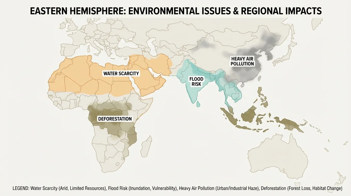
Desertification, the process by which fertile land becomes more desert-like, threatens some dryland areas. Climate change can make these problems worse by increasing heat, shifting rainfall, and raising sea levels. Low-lying coastal regions in Asia may face greater flood risk, while farming zones may need to adapt to new weather patterns.
Case study: Water in the Nile Basin
The Nile River flows through multiple countries, so physical geography and political geography are tightly connected.
Step 1: Identify the physical feature
The Nile provides water for farming, transportation, and city life in an otherwise dry region.
Step 2: Identify the political issue
Because the river crosses borders, upstream and downstream countries may disagree about dams and water use.
Step 3: Connect to regional differences
Countries along the river may have different needs for irrigation, electricity, and population support, so they may see the same river in different ways.
This example shows why environmental issues often require regional cooperation.
The pattern in [Figure 3] makes an important point: the environment influences culture, trade, and politics all at once. A drought can affect farming, raise food prices, increase migration, and even cause tension between regions.
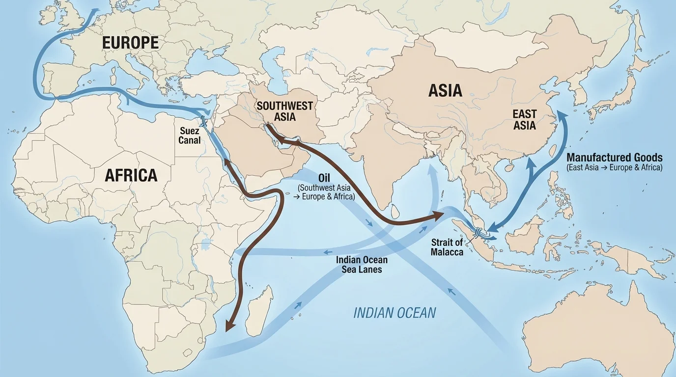
[Figure 4] shows major trade routes in the Eastern Hemisphere connecting producers, consumers, and ports across continents. Today, countries are linked through economic interdependence, meaning they depend on one another for resources, products, services, and markets. This network works through shipping routes, air travel, pipelines, internet connections, and financial systems.
For example, oil from Southwest Asia powers factories, vehicles, and homes in many regions. Manufactured goods from East Asia are sold in Europe, Africa, and beyond. Wheat, technology parts, clothing, and medicines often cross several borders before reaching consumers. A product used in one country may depend on raw materials from another and assembly in a third country.
This interdependence creates benefits. Countries can specialize in what they produce well and trade for what they lack. Trade can increase choice, lower some costs, and spread technology. But it also creates vulnerability. If one route is blocked or one country changes policy, many other places may be affected.
Narrow waterways called chokepoints are especially important. The Suez Canal connects the Mediterranean Sea and the Red Sea, reducing travel distance between Europe and Asia. The Strait of Malacca links the Indian Ocean and the Pacific region. If shipping is delayed in these places, prices and supply chains can be affected far away.
Trade barriers change these patterns. A country may raise tariffs to protect local businesses. It may use sanctions to pressure another government. It may require inspections, licenses, or special standards. These barriers can slow trade, increase prices, and sometimes reduce cultural exchange as well.
The route network in [Figure 4] helps explain why an event in one place can matter globally. A blocked canal, damaged port, or political crisis can affect factories, stores, and households in many regions that seem far away.
Regions are not isolated boxes on a map. They have distinct characteristics, but they also interact constantly through migration, trade, communication, and environmental systems.
The Silk Road is one of the clearest examples of cultural diffusion shaped by geography. It crossed deserts, mountain edges, and oasis towns. Because travel was hard, exchange happened in stages. Merchants carried goods such as silk and spices, but religions, inventions, and diseases also moved along these routes.
The Suez Canal shows how humans can reshape geographic patterns. This canal made a faster water route between Europe and Asia. It increased trade and made Egypt strategically important. A political decision affecting this canal can influence shipping across several regions.
The Himalayas help explain regional difference. They limited easy movement, helping South Asia develop distinctive traditions, languages, and religious histories. Yet they did not completely isolate the region. Select passes allowed contact and exchange.
Monsoon Asia shows how climate can shape culture. Seasonal winds and rains affect farming calendars, settlement patterns, and even architecture. Communities plan around expected rainy and dry seasons. When monsoons fail or become extreme, both economies and daily life are disrupted.
Energy trade in Southwest Asia shows the power of economic interdependence. Countries with large oil and gas reserves influence global energy markets, while importing countries depend on steady access to those resources. This can create wealth, alliances, and political tension at the same time.
Geography often creates situations where different groups see the same issue differently. A government upstream on a river may want to build a dam for electricity. A downstream country may worry about reduced water for farms. A port city may support more shipping for jobs, while local residents may worry about pollution. A country may see tariffs as protection, while trading partners see them as unfair barriers.
These different viewpoints are part of regional geography. People respond based on where they live, what resources they have, and what challenges they face. That is why geographers study perspective as well as location. Maps and data matter, but so do human goals and concerns.
"Geography is not just where things are. It is why they are there, who benefits, and who is affected."
When students compare regions, they should ask several questions: What physical features shape this place? What political choices affect people here? What is spreading into or out of the region? What environmental issues matter most? How is this region connected to others?
Physical features like rivers, deserts, mountains, and seas influence where people move and how easily ideas spread. Political features like borders, laws, and alliances influence whether those movements are welcomed, taxed, delayed, or blocked. Together, they shape cultural diffusion and create regional differences.
This is why the Eastern Hemisphere contains both strong regional identities and deep connections. Food, language, religion, technology, and trade all move across space, but they do not move everywhere in the same way. Geography channels movement. Politics regulates movement. Culture changes through movement.
Modern environmental issues and global trade make these connections even clearer. A drought, a polluted air mass, a blocked canal, or a tariff increase can affect many places at once. To understand regions, we have to study nature, human decisions, and global networks together.