A river can cross several countries, a desert can separate communities for hundreds of miles, and one valuable mineral can turn a small town into a major trading center. Geography is not just about maps. It helps explain why some places grow rich from trade, why others struggle over scarce water, and why people move across borders in times of danger. When we study where resources are located and who can reach them, we learn a great deal about how people live.
Every region has a unique combination of landforms, climate, water sources, and natural resources. These features influence where people build cities, grow crops, travel, and work. In the Eastern Hemisphere, especially in North Africa and the Middle East, geography strongly shapes human life. Deserts limit farming, rivers support settlement, and coastlines open trade routes. Physical patterns, as [Figure 1] shows, help explain why some areas become population centers while others remain sparsely settled.
Geographic location means where a place is on Earth and what surrounds it. A country near major rivers may have more farmland. A country surrounded by desert may depend more on trade, irrigation, or imported food. A city placed near a sea or caravan route may grow because merchants can move goods through it. Geography does not decide everything, but it creates opportunities and limits that affect human choices.
The distribution of resources is not equal. Some regions have abundant oil, fertile soil, or freshwater, while others have very little. This uneven pattern matters because people need resources to survive and to build economies. If one area has something many others need, it can gain wealth or power. If an important resource is scarce, people may compete for it.

For example, much of the Middle East has an arid climate, meaning it receives very little rainfall. This makes freshwater extremely valuable. In contrast, some places along river valleys can support farming, transportation, and dense populations. Long ago, traders also learned how to cross dry lands using camels, linking distant regions in trade networks. The same geography that made life difficult in some places also made certain trade routes important.
Natural resource is anything from nature that people use, such as water, fertile land, minerals, forests, or oil.
Scarcity means there is not enough of something to meet all wants or needs.
Trade route is a path used to move goods from one place to another.
When a resource is limited, people must decide who gets to use it, how much they can use, and who makes the rules. These decisions can affect farming, jobs, health, migration, and even peace between countries. That is why geographers study both the land and the people living on it.
Resources can be grouped in different ways. Some are renewable, like sunlight or wind, because nature replaces them quickly. Others, such as oil or certain minerals, form over very long periods and are considered nonrenewable. Water is renewable in the long run because of the water cycle, but in dry places it can still be scarce and difficult to access.
Not all valuable resources are modern fuels or metals. Salt, for example, was once one of the most important trade goods in the world. People needed it to preserve food and stay healthy. Areas with large salt deposits could trade it to regions that lacked it. This created powerful commercial connections across deserts and grasslands.
Uneven resource distribution happens because of natural processes. Rivers flow in certain valleys, rain falls more in some climates than others, and mineral deposits form only in particular geologic conditions. Human history also matters. A government might build dams, wells, roads, or ports that increase access to a resource. Another government might block access or control exports. So resource geography is partly natural and partly shaped by human decisions.
Resources create both opportunity and pressure
When a region has an important resource, it may gain wealth through farming, mining, or trade. At the same time, heavy dependence on one resource can create pressure. People may compete over access, ecosystems may be damaged, and groups may disagree about who benefits. The same river, road, or salt mine can support life while also becoming a source of conflict.
This idea helps us understand the three examples in this lesson: Middle Eastern water rights, the acceptance of refugees from other countries, and the salt trade. In each case, geography affects who has access, who must adapt, and how economic and social change spreads through a region.
Water is one of the clearest examples of how resource location shapes human life. In the Middle East, several major rivers and water systems cross political borders. Countries may share the same river, but they may not share it equally. The challenge of access, as [Figure 2] illustrates, is especially serious when populations are growing and climates are dry.
Water rights are the legal or political claims to use water from rivers, lakes, underground sources, or other supplies. In some parts of the Middle East, rivers such as the Jordan, Tigris, and Euphrates flow through more than one country. This means actions taken upstream can affect people downstream. If one country builds a dam or diverts water for irrigation, another country may receive less water.
This issue is not only about governments. Farmers need water for crops. City residents need it for drinking, cooking, and sanitation. Industries need it for production. When rainfall is low, every group feels the pressure. A shortage can raise food prices, reduce farm income, and increase tension between rural and urban areas.
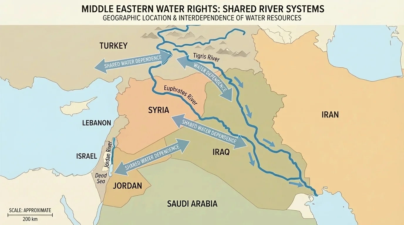
Because of this, control over water can become a political issue. Upstream countries often have an advantage because they can store or redirect water before it reaches others. Downstream countries may argue that they have historic rights or urgent needs. Negotiations over water can be difficult, especially when countries already disagree on borders or security.
The social impact of water scarcity is serious. Families may have less reliable access to clean water. Farmers may leave dry land and move to cities in search of work. Overcrowded cities can face pressure on housing, schools, transportation, and health systems. In this way, a physical resource problem becomes a social one.
Case study: Shared rivers and unequal control
Consider a region where one country is upstream and another is downstream.
Step 1: The upstream country builds a dam to store water for electricity and farming.
Step 2: Less water reaches the downstream country during important growing seasons.
Step 3: Farmers downstream harvest less food, and local prices rise.
Step 4: The downstream government protests and asks for a water-sharing agreement.
This example shows how a change in one location can affect jobs, food supplies, and political relations far away.
Some countries respond with technology. They may use drip irrigation, which delivers water directly to plant roots and reduces waste. Others invest in desalination, a process that removes salt from seawater. Desalination can increase water supply, but it is expensive and requires energy. Wealthier countries are more able to build such systems than poorer ones.
Cooperation is also possible. Water-sharing agreements, conservation programs, and joint projects can reduce conflict. The shared river systems seen earlier in [Figure 2] remind us that natural systems do not stop at political borders, so successful solutions often require countries to work together.
Some countries in the Middle East recycle wastewater for farming and landscaping. This helps stretch limited freshwater supplies in places where every drop matters.
Environmental impact matters too. Overuse of rivers or groundwater can damage wetlands, lower water tables, and harm wildlife. When water resources shrink, ecosystems and human communities both suffer.
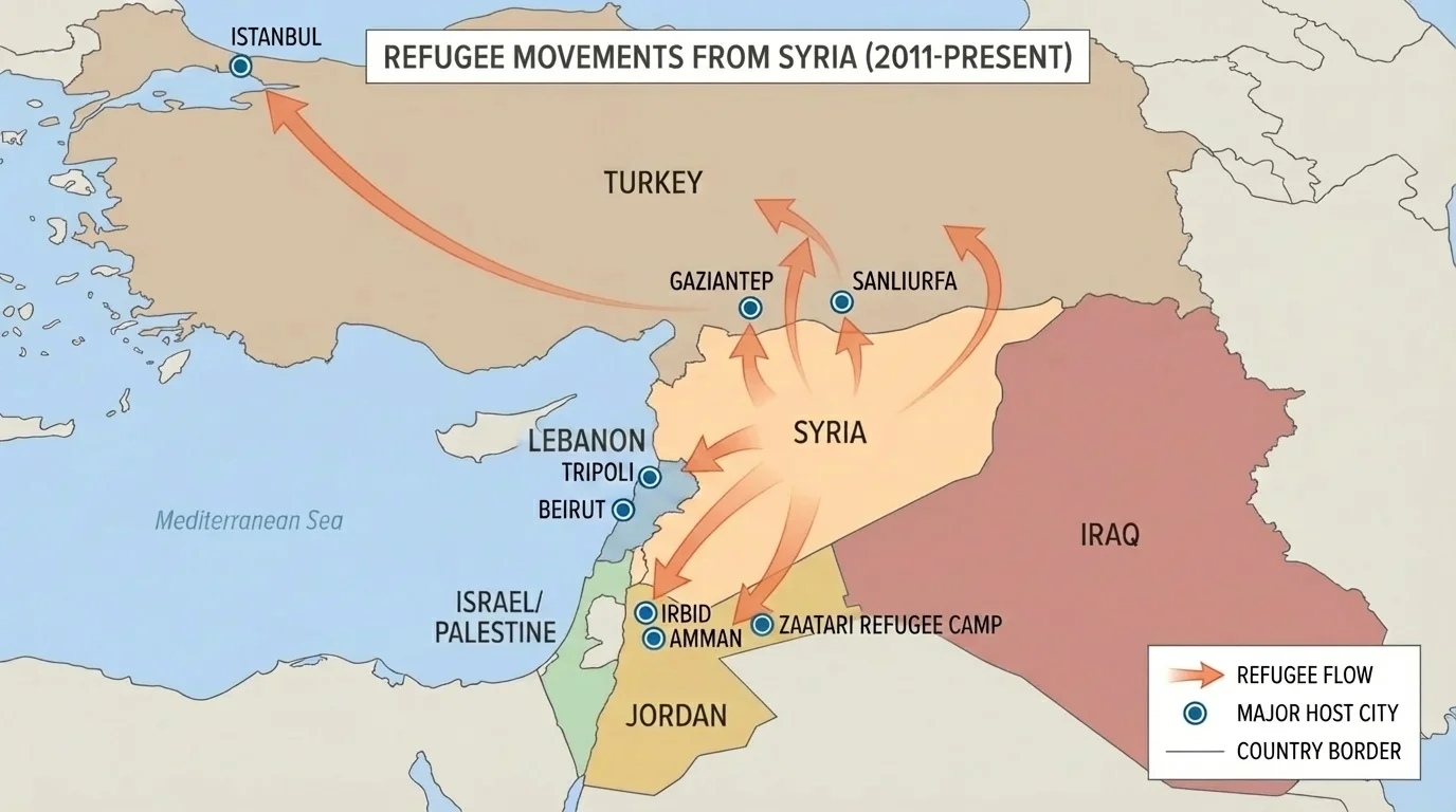
Resources are not only things like water, oil, or salt. People themselves bring skills, labor, ideas, and culture. When war, disaster, or persecution forces people to leave home, geography helps determine where they go and what happens next. Nearby countries often receive the largest number of refugees because crossing a short land border is faster and safer than traveling long distances. The regional patterns of movement, as [Figure 3] shows, are closely tied to geography.
A refugee is a person who leaves their country because of danger and cannot safely return home. In recent years, countries near conflict zones in the Middle East, such as Turkey, Jordan, and Lebanon, have hosted large numbers of refugees, especially from Syria. Their location made them the first destination for many families escaping violence.
The arrival of refugees can create immediate needs. More people require more housing, clean water, food, schools, and medical care. If a host country is small or already has limited resources, the pressure can be intense. Rents may rise, classrooms may become crowded, and health systems may struggle to keep up.
At the same time, refugees can contribute to the economy. Adults may work, open businesses, or bring useful skills. Children who attend school may become part of the future workforce. New communities can increase trade, language diversity, and cultural exchange. So the impact is often mixed: there are real challenges, but also possible long-term benefits.
Host countries may view refugee acceptance through different perspectives. Some citizens may focus on humanitarian duty and safety. Others may worry about jobs, public services, or political stability. Governments must balance compassion with practical planning. Geography affects these choices because a country near a conflict zone may receive people very quickly and in very large numbers.
| Possible Impact | Economic Effects | Social Effects |
|---|---|---|
| Population increase | Higher demand for goods, housing, and jobs | More crowded schools and clinics |
| New workers and skills | Can support businesses and local economies | Cultural exchange and new communities |
| Pressure on resources | Higher government spending on services | Tension if resources seem unfairly shared |
| International aid | Outside funding may help local infrastructure | Can improve support systems for both refugees and citizens |
Table 1. Economic and social effects that may occur when a country accepts large numbers of refugees.
Refugee movement is also linked to environmental conditions. Drought can worsen economic hardship, especially in farming areas. If crops fail and jobs disappear, communities become more vulnerable. This does not mean climate alone causes migration, but environmental stress can add to political and economic problems.
Case study: A host country near a conflict zone
A neighboring country accepts many refugees over a short period of time.
Step 1: The population of border towns rises quickly.
Step 2: Demand for water, food, and shelter increases.
Step 3: Local businesses may sell more goods, but prices and rents can also rise.
Step 4: Schools and hospitals need more staff and support.
The result is a mix of challenges and opportunities, depending on planning, aid, and local conditions.
Looking again at the regional flows shown in [Figure 3], we can see why nearby countries often carry the largest burden first. Distance matters. Borders matter. So do roads, cities, and access to aid.
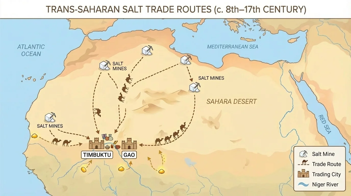
Today, salt seems ordinary because it is common in stores and inexpensive in many places. But for much of history, salt was precious. People used it to flavor food, preserve meat and fish, and support health. In some regions, salt was so valuable that it was traded over long distances. The geography of North Africa, as [Figure 4] shows, helps explain why the salt trade became so important.
The salt trade connected places that had salt deposits with places that needed salt but did not have easy access to it. In and around the Sahara, traders moved salt in large blocks from desert mines to trading cities. Camel caravans crossed difficult terrain because the profits were worth the danger and effort.
Geography shaped this trade in several ways. First, salt deposits formed in specific desert areas, not everywhere. Second, the Sahara was harsh, with extreme heat and little water, so only skilled traders using camels and known routes could cross it. Third, cities located at the edge of the desert became major centers where goods were exchanged.
Salt was often traded for gold, grain, cloth, and other goods. This exchange helped cities such as Timbuktu and Gao grow wealthy and influential. Merchants, scholars, and travelers moved along with the goods, spreading ideas, religion, and culture. So the salt trade was not only economic. It also changed societies.
Control over trade routes brought power. Rulers who protected caravan routes or taxed trade could gain wealth. Communities located along major routes benefited from markets, jobs, and contact with distant regions. On the other hand, people far from those routes had fewer opportunities to profit.
"Trade follows geography, but it also changes the meaning of geography."
The salt trade also shows how a resource can be valuable even if it is simple. Salt was not rare everywhere, but where it was scarce, demand was high. This is a basic economic idea: when something important is scarce in one area and available in another, trade often develops between them.
As the caravan routes in [Figure 4] make clear, transportation mattered as much as the resource itself. A resource has little economic value to distant people if no safe route exists to move it.
These three examples may seem different, but they are connected by the same geographic idea: location shapes access. In the Middle East, shared rivers create competition and cooperation over water. In refugee movements, nearby countries are affected first because of their location. In the salt trade, cities on important routes gain wealth because they connect producers and buyers.
Each example also shows both economic impact and social impact. Economic impact involves jobs, prices, trade, farming, infrastructure, and government spending. Social impact includes health, education, housing, migration, culture, and relationships between groups. A shortage of water can lower crop production and also force families to move. Refugee arrivals can increase labor supply and also strain classrooms. Salt routes can enrich cities and also shift political power.
| Example | Key Resource or Factor | Economic Impact | Social Impact |
|---|---|---|---|
| Middle Eastern water rights | Freshwater in shared rivers and aquifers | Affects farming, energy, and food prices | Can cause migration, tension, or cooperation |
| Acceptance of refugees | Population movement and access to services | Raises demand for jobs and housing; may add workers | Changes communities, schools, and culture |
| Salt trade | Salt deposits and trade routes | Creates wealth through exchange and taxes | Spreads ideas, religions, and urban growth |
Table 2. Comparison of how geography affects economic and social outcomes in the three case studies.
A region's geography can create advantages, but those advantages are not guaranteed forever. Climate change, conflict, technology, and population growth can all change how resources are used. A river that once seemed sufficient may become stressed. A trade route may lose importance if new transportation methods appear. A host country may need more support as migration continues.
People are not passive. They respond to geography in creative ways. Farmers build irrigation systems. Governments negotiate treaties. Engineers design desalination plants. Traders create routes across difficult landscapes. Communities organize aid for newcomers. Geography shapes choices, but people still make decisions that can improve or worsen conditions.
Good decision-making often requires thinking at more than one scale. Local leaders may focus on a town's water system or school capacity. National governments may think about budgets, border policy, and infrastructure. International organizations may provide aid or help countries negotiate. Problems connected to geography often cross borders, so solutions sometimes must cross borders too.
Earlier geography lessons may have shown that climate, landforms, and access to waterways affect settlement patterns. This lesson builds on that idea by showing that the same physical features also influence resources, trade, migration, and political decisions.
Technology can reduce some limits, but it rarely removes them completely. Desalination creates freshwater, yet it costs money and energy. Better roads improve trade, but deserts still remain difficult places to cross. Aid can help refugee communities, but planning is still needed to support housing and jobs. Every solution has benefits and trade-offs.
One of the most important skills in geography is understanding perspective. Different groups in the same region may see the same issue in very different ways. An upstream government may see a dam as progress. A downstream farmer may see it as a threat. A city may welcome refugee labor while worrying about rising rents. A merchant may view a desert as an opportunity, while a traveler sees danger.
Regional perspective also matters because places are connected. The map in [Figure 1] shows that rivers, deserts, and trade corridors link communities rather than fully separating them. Decisions in one location can have effects far away. That is why geographers ask not only, "Where is this resource?" but also, "Who depends on it?" and "Who is affected when access changes?"
Studying resource distribution helps us better understand fairness, power, and adaptation. It shows why some conflicts are not simply about politics but also about land, water, movement, and survival. It also shows that cooperation is possible when people recognize shared needs.