If you started in the snowy Rocky Mountains and drove east across Colorado, you would cross tall peaks, broad valleys, rolling grasslands, and wide open plains. Few states change so much from one side to the other. Colorado is almost like several landscapes packed into one place, and that makes it exciting to compare with its neighbors.
Colorado is in the western United States and touches seven other states. It borders Wyoming to the north, Nebraska to the northeast, Kansas to the east, Oklahoma at a short border in the southeast, New Mexico to the south, Arizona at the Four Corners point, and Utah to the west. Because Colorado sits near the middle of these different landscapes, it shares some features with each neighbor but also has important differences.
When geographers study places, they look at physical geography. Physical geography means the natural features of Earth, such as mountains, rivers, plains, plateaus, deserts, and climate. In Colorado, physical geography helps explain why some areas have ski towns, some have farms, and some have dry canyon lands.
Physical geography is the study of Earth's natural features. It includes landforms, water, climate, soils, and plants in different places.
Landforms are natural shapes on Earth's surface, such as mountains, plains, valleys, plateaus, mesas, and canyons.
Colorado is well known for high elevation. In fact, many places in the state are more than 8,000 feet above sea level. That high land affects weather, rivers, and plants. Neighboring states may share some of these features, but not all of them have the same height, steep mountains, or wide changes in elevation.
A good comparison starts with a physical map, as shown in [Figure 1], because a map helps us see landforms, rivers, and elevation patterns across Colorado and the surrounding states. On a physical map, mountains are often shown in darker colors or raised areas, while plains and lowlands are shown in lighter or flatter-looking colors.
Another useful tool is an elevation map. Elevation means the height of land above sea level. Colorado has some of the highest land in the country, while states like Kansas are much flatter and lower. Compass directions also help. If we move west in Colorado, we often encounter mountains and plateaus. If we move east, we usually enter plains regions.
Geographers also use river maps, climate maps, and satellite images. A river map shows where water flows. A climate map helps compare wetter mountain areas with drier plains or desert lands. Satellite images show what the land really looks like from above, making patterns easier to notice.
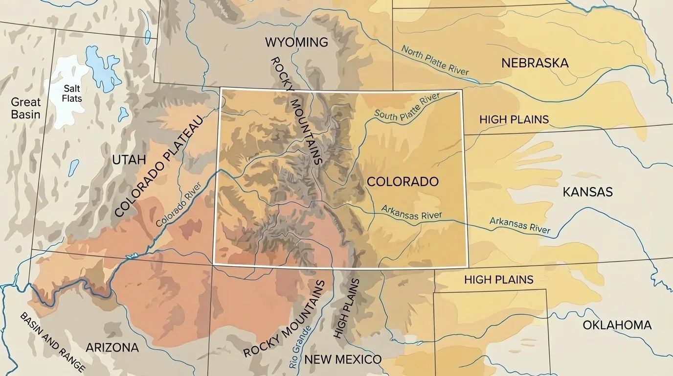
When students compare places, they ask questions such as: Which states have mountains? Which are mostly plains? Where are the driest areas? Which rivers begin in Colorado and flow into other states? These questions turn maps into tools for discovery, not just pictures.
Remember that a map key explains symbols and colors, and a compass rose shows direction. These tools help you read a map accurately and compare one place to another.
As we continue, keep using the ideas from [Figure 1]. Colorado sits in the middle of very different natural regions, so every border tells a different geographic story.
Colorado has several important physical regions. The most famous region is the Rocky Mountains, a long mountain chain with high peaks, steep slopes, forests, and deep valleys. Many of Colorado's rivers begin in these mountains because melting snow runs downhill.
[Figure 2] East of the mountains are the High Plains. Even though they are called plains, they are not at sea level. They are high, wide grasslands that slope gently eastward. This region is much flatter than the mountains and is important for farming and ranching.
In western and southwestern Colorado, there are plateaus, mesas, and canyon areas connected to the plateau lands of the Colorado Plateau region. Southern Colorado also includes the San Luis Valley, a large high valley surrounded by mountains. Major rivers include the Colorado River, the Arkansas River, the South Platte River, and the Rio Grande.
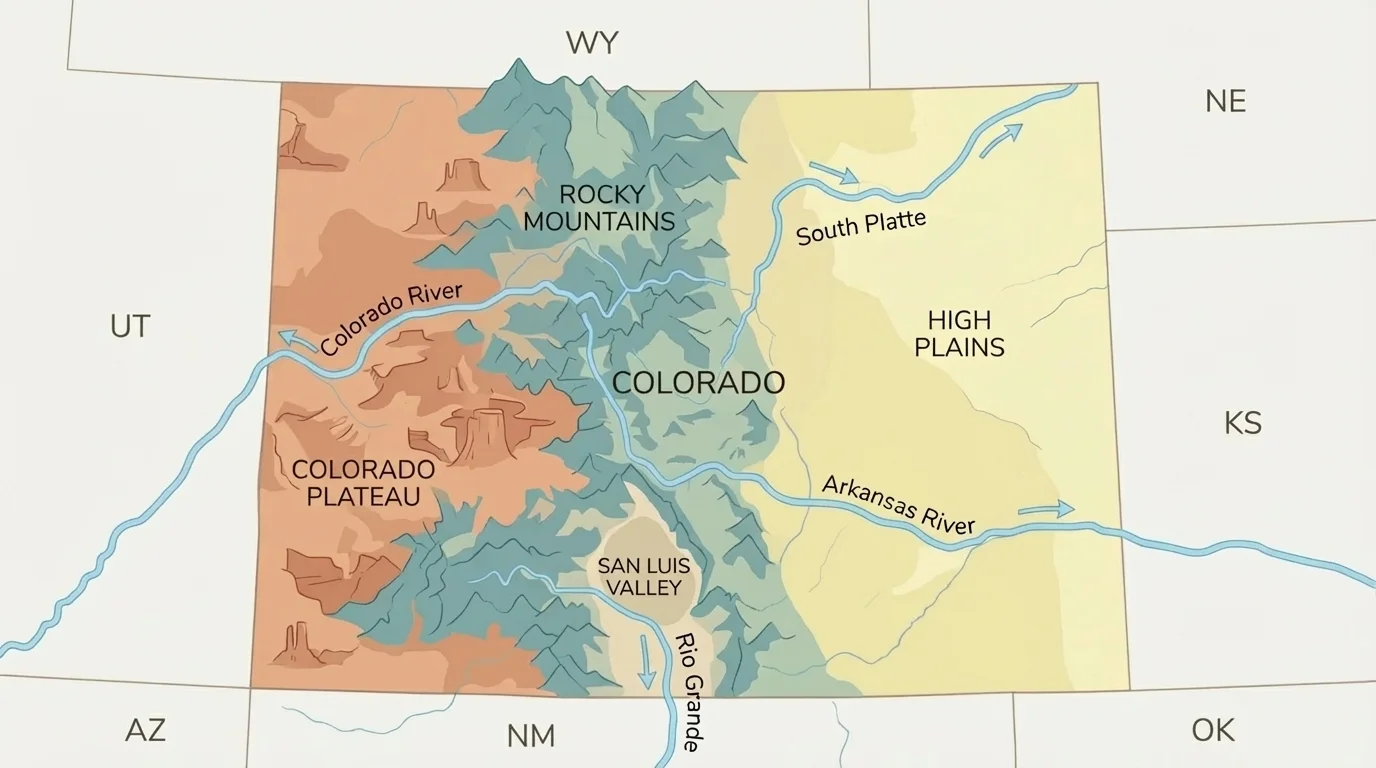
This variety is one reason Colorado is different from many neighbors. Some nearby states share plains with Colorado. Others share plateaus or desert lands. A few share mountain ranges. But not many have such a strong mix of all of these in one state.
Colorado is one of the highest states in the United States. Its average elevation is much higher than that of most neighboring states, which helps create cooler mountain climates and lots of snow.
Because of these regions, Colorado acts like a meeting place between mountain lands, grasslands, and dry western plateaus. That is why a close look at each neighboring state reveals both shared features and clear differences.
Wyoming is north of Colorado. Like Colorado, Wyoming has mountains and high plains. Both states share part of the Rocky Mountain system, and both have cold winters in many areas. However, Wyoming is generally more open, less populated, and has larger stretches of high plains and basins between mountain ranges. Colorado usually has more dramatic contrasts between very high peaks and major Front Range cities.
Nebraska, to the northeast, is much flatter than Colorado. Nebraska is known mostly for plains, grasslands, and river valleys. It does not have the tall Rocky Mountains that Colorado has. Still, eastern Colorado and western Nebraska do have similarities. Both areas are part of the Great Plains, with open land, farming, and fewer steep slopes.
Water also helps us compare them. Some rivers that begin in Colorado flow toward Nebraska. This means Colorado's mountain snow can affect places far away. Nebraska depends heavily on plains rivers and groundwater, while Colorado depends strongly on mountain snowpack and streams.
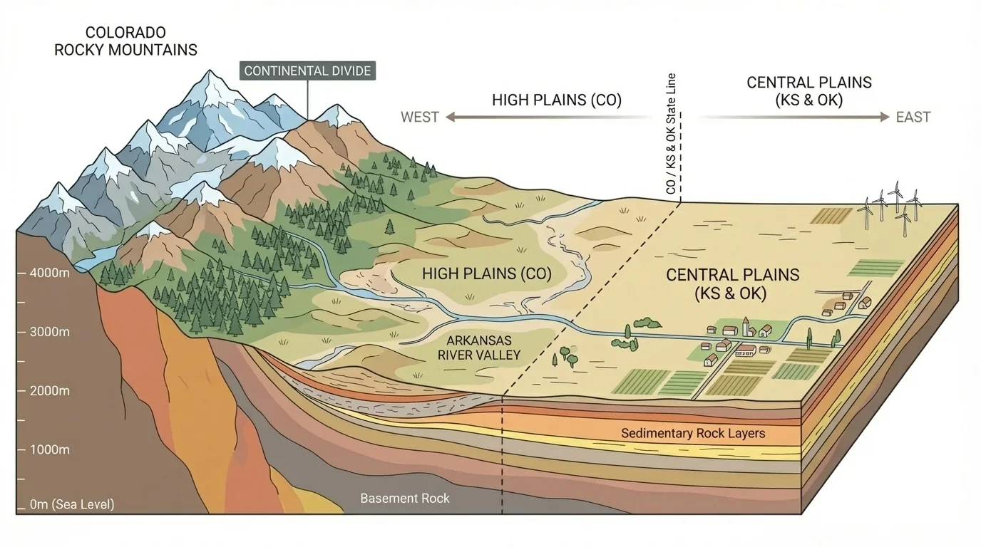
Mountains collect water for the region
Snow that falls in the Colorado mountains melts and feeds rivers. These rivers carry water into other states, so Colorado's high land matters not only inside Colorado but also across the Great Plains and the Southwest.
[Figure 3] Looking back at [Figure 1], the map makes it easy to see that Colorado connects mountain regions to plains regions. Wyoming shares more of the mountain-and-high-plain pattern, while Nebraska shares more of the plain-and-river pattern.
If you travel east from central Colorado, the land gradually becomes flatter. Kansas and Oklahoma are much better known for plains, prairies, and gently rolling land than for mountains. Colorado shares this kind of land in its eastern part, especially in the High Plains.
The biggest difference is elevation and relief. Relief means how much the land rises and falls. Colorado has very high relief in its mountain areas, with steep peaks and deep valleys. Kansas has low relief across much of the state because the land is flatter. Oklahoma has plains and some hills, but it still does not match Colorado's tall mountain scenery.
Climate is another difference. Colorado's mountains can be cool and snowy, while eastern Colorado, Kansas, and Oklahoma are often warmer and windier. Parts of Kansas and Oklahoma can have strong thunderstorms and tornadoes because of the way warm and cool air masses meet over the plains. Colorado can have storms too, but mountain weather adds different patterns.
These states also show how one region can continue across borders. The Great Plains do not stop at the Colorado line. They stretch across eastern Colorado into Kansas, Nebraska, and Oklahoma. So Colorado is similar to these states on the plains side, but very different on the mountain side.
Case study: Eastern Colorado and western Kansas
Step 1: Look at the land.
Both areas have wide grasslands, open skies, and land used for farming and ranching.
Step 2: Compare the elevation.
Eastern Colorado is still fairly high above sea level, even when it looks flat. Western Kansas is flatter and generally lower.
Step 3: Notice the major difference.
If you keep traveling west in Colorado, the Rocky Mountains rise sharply. Kansas does not have that sudden wall of mountains.
This comparison shows how Colorado can be partly similar to a neighbor while still being very different overall.
Later, when people decide where to grow crops or build roads, these land differences matter. Flatter land is easier for large farms and straight highways, while mountain land creates winding roads, passes, and tunnels.
New Mexico, south of Colorado, shares some mountain areas and some dry lands. Northern New Mexico has parts of the Rocky Mountains, so in that way it is similar to southern Colorado. Both states also have high valleys and river systems, including the Rio Grande. But New Mexico generally has more desert and semiarid land, especially farther south.
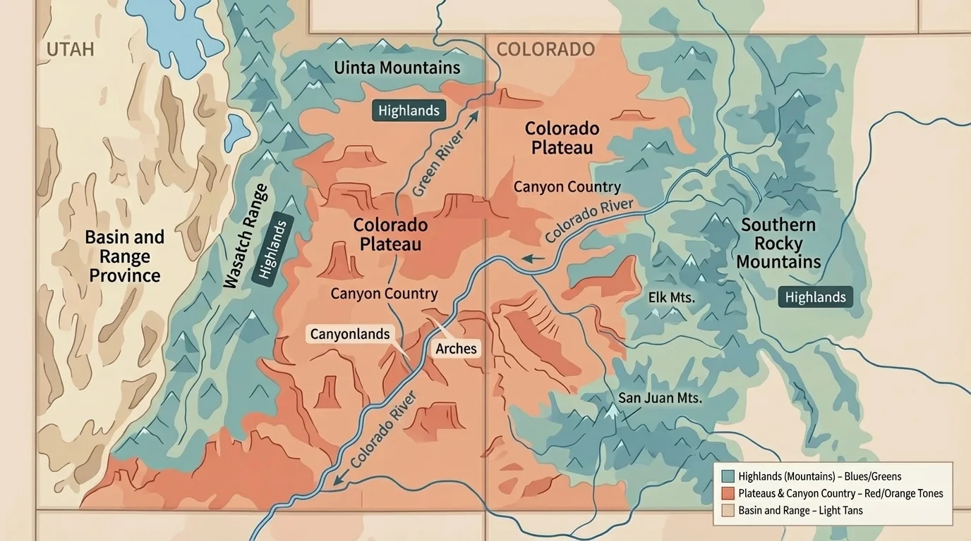
Arizona touches Colorado only at the Four Corners point, where four states meet. Arizona is famous for deserts, mesas, and deep canyons, including the Grand Canyon. Colorado does have mesas and canyon country in the west, but much more of Colorado is high mountain land than Arizona.
One strong similarity among Colorado, New Mexico, Arizona, and Utah is the presence of dry plateau landscapes in the Southwest. Western and southwestern Colorado connect naturally to these lands. However, Colorado's cooler temperatures and higher mountains make it different from the hotter desert parts of Arizona.
The Four Corners is the only place in the United States where four states meet at one point: Colorado, Utah, Arizona, and New Mexico.
[Figure 4] This means Colorado is both a Rocky Mountain state and, in part, a state with Southwestern plateau landscapes. That mix is unusual and helps explain why its geography is so varied.
Utah, to the west, shares some of Colorado's most striking western landscapes. Both states have high land, plateaus, mesas, cliffs, and river-cut canyons. The Colorado River begins in Colorado and flows into Utah, linking the two states physically.
Even with these similarities, Utah is generally drier and has larger desert and basin areas. Colorado has more extensive high mountain regions with heavy snow. Utah has mountains too, but its canyon and desert landscapes are more dominant in many areas than they are in Colorado.
This comparison helps students see that state borders do not stop landforms. Plateaus, rivers, and canyons often continue from one state into another. The border is a human line on a map, but the land itself stretches across it.
When we compare western Colorado with Utah, we are reminded that natural regions are often bigger than one state. Geographers look at the whole pattern, not just the border line.
Physical geography shapes how people live. In mountain parts of Colorado, towns may grow near valleys, passes, and rivers. These places may depend on tourism, skiing, hiking, and mining history. On the plains, large areas of open land are useful for farming wheat, raising cattle, and building straight roads.
Water is especially important. Because Colorado has so many mountains, it acts like a water tower for nearby regions. Snow falls in winter, collects in the mountains, and melts later. That water flows into rivers used by farms, towns, and cities in Colorado and other states.
Neighboring states use their geography in different ways. Kansas and Nebraska have large farming regions on the plains. Utah and Arizona have famous canyon parks and dry landscapes. New Mexico has a mix of mountains, mesas, and desert lands. Wyoming has wide high country and mountain ranges. Geography helps explain these patterns.
Why elevation matters
Higher land is often cooler and may get more snow. Lower, flatter land is often warmer and easier to farm. That is one reason Colorado can have snowy ski slopes in one area and dry grasslands in another.
Colorado's physical geography also affects transportation. Crossing the Rocky Mountains is harder than crossing the plains, so mountain roads need passes, bridges, and careful planning. This is one reason many of Colorado's larger cities, such as Denver, grew along the Front Range, where the mountains meet the plains.
The table below organizes some of the most important similarities and differences.
| State | Main Landforms | Similarity to Colorado | Difference from Colorado |
|---|---|---|---|
| Wyoming | Mountains, high plains, basins | Shares Rocky Mountain and high plains regions | Usually less varied and less populated than Colorado |
| Nebraska | Plains, river valleys | Similar to eastern Colorado plains | No tall Rocky Mountains |
| Kansas | Prairies, plains | Shares Great Plains with eastern Colorado | Flatter and lower overall |
| Oklahoma | Plains, hills, some low mountains | Similar open plains in some areas | Warmer overall and lacks Colorado's high mountain ranges |
| New Mexico | Mountains, mesas, desert, valleys | Shares some mountains and dry high lands | More desert in many regions |
| Arizona | Desert, plateaus, canyons, mesas | Shares plateau and canyon features near Four Corners | Hotter and more desert-dominated |
| Utah | Plateaus, canyons, mountains, basins | Shares canyon country and plateau lands | Drier with larger desert and basin regions |
Table 1. Comparison of Colorado's neighboring states by major landforms, similarities, and differences.
A table like this is useful, but geographers also look at exact locations on maps. For example, eastern Colorado may be very similar to western Kansas, while western Colorado may be much more similar to eastern Utah. This shows that comparisons depend on which part of a state you study.
The Front Range is a great example of Colorado's special location. It is where the mountains rise near the plains. Cities such as Denver and Colorado Springs grew there because people could reach both mountain and plain resources. Few neighboring states have such a dramatic meeting of landscapes next to major cities.
The San Luis Valley in southern Colorado offers another example. It is a high valley ringed by mountains and connected to the Rio Grande. This region shares some features with northern New Mexico, showing how natural regions continue across borders.
At Four Corners, students can see how Colorado connects to Utah, Arizona, and New Mexico at one point. The land there includes mesas, cliffs, and dry plateau country. That area feels very different from central Colorado's high mountain forests, proving again that one state can contain many landscapes.
"Geography is the study of places and the relationships between people and their environments."
— A central idea in geography
When you compare Colorado with its neighbors, the biggest lesson is that borders are not the same as landforms. Mountains, plains, plateaus, and rivers cross state lines. Colorado shares the Great Plains with some neighbors, the Rocky Mountains with others, and Southwestern plateau lands with others. Yet Colorado's unusual mix of very high mountains, broad plains, valleys, and canyon country makes it stand out.