A river can feed a civilization, a mountain range can slow an army, and a border can change the lives of millions of people. Geography is not just about where places are. It is also about how places work. Throughout history, people have moved because of land, water, weather, and government decisions. To understand why events happened, historians often ask a geography question first: What was this place like, and how did that shape human choices?
When we study movement, we look at causes and consequences. A cause is why something happens. A consequence is what happens after. People move for many reasons. Some move to find land, water, safety, or work. Others are forced to move by war, slavery, or government actions. In every case, both physical features and political features matter.
Physical features are natural parts of Earth, such as rivers, mountains, deserts, plains, forests, and oceans. Political features are places and boundaries created by people, such as countries, states, cities, and borders. Physical features shape what is possible in a place. Political features shape what is allowed, controlled, or protected in a place.
Movement is the travel of people, goods, and ideas from one place to another. In geography and history, movement can be voluntary, when people choose to go, or forced, when they are made to go.
Adaptation is the way people change how they live in order to fit their environment. This can include building certain kinds of homes, growing specific crops, or using special transportation.
Think about a town near a river. The river may provide water, fish, rich soil, and a route for travel. That makes settlement easier. But if a government places a border across the river or charges taxes at crossings, movement changes. Geography and government often work together. Sometimes they help people move. Sometimes they block movement.
[Figure 1] Landforms often act as natural routes and barriers. Rivers guide travel and settlement, while mountains can make travel harder. People often settle in river valleys because the land is fertile and water is nearby. They may avoid very dry deserts or steep mountain slopes unless they have strong reasons to stay there.
River valleys have supported many civilizations because rivers can be used for drinking water, farming, fishing, and transportation. Flat land near rivers is easier to farm than rocky hills. Boats can carry goods more easily than people carrying heavy loads on foot. This means trade often grows near rivers.
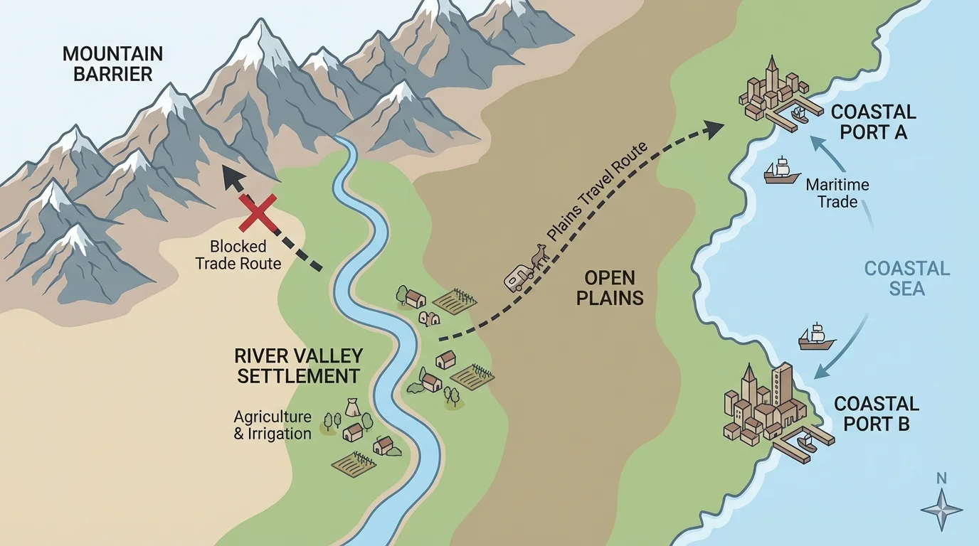
Mountains can protect people from attack, but they can also isolate communities. If crossing a mountain range is difficult, people on each side may develop different languages, customs, or economies. Plains and grasslands, by contrast, often allow easier movement. Large groups of people, wagons, and herds can travel across flatter land more easily than across steep terrain.
Climate also affects movement. A place with long winters, little rainfall, or frequent drought may be harder to farm. A place with mild weather and enough water may attract settlers. However, climate can change over time, and people adapt. They may dig irrigation canals, store food, wear protective clothing, or move with the seasons.
Coasts are another important physical feature. Coastal areas often become centers of trade because ships can connect one region to another. Ports grow where harbors are safe and deep enough for boats. Many famous cities developed along coasts because it was easier to move goods by water than by land. Routes connect settlements to coastlines and river systems.
The largest cities in the world today are still often near rivers or coasts. This pattern connects modern life to ancient geography.
Deserts show another side of geography. Harsh heat and low rainfall make settlement difficult, but deserts are not empty. People who live there adapt carefully. They may settle near oases, build homes that stay cool, and travel at certain times of day. Desert trade routes have been important in many places, including Africa and Asia.
A mountain is natural, but a border is made by people. Political features can be just as powerful as physical ones. Governments create laws about land ownership, trade, taxes, immigration, and safety. These decisions can encourage movement or stop it. If a country welcomes settlers, more people may arrive. If a border is closed during conflict, movement may slow or stop.
Borders separate one political area from another. Some borders follow physical features like rivers or mountain ridges. Others are straight lines drawn on maps. Borders matter because they decide who controls land and resources. They can also separate families, languages, and trading partners.
How political decisions shape movement
People do not move only because of nature. They also move because leaders make choices. A government may build roads, create new territories, remove people from land, or pass laws that welcome or restrict newcomers. These actions can change history quickly, even if the physical land stays the same.
Colonies, states, and territories are political features too. When powerful nations claimed land in the Americas, Africa, and Asia, they changed who controlled resources and where people moved. Settlers entered some places. Native peoples were pushed out of others. Political power changed maps, and those new maps changed lives.
Capitals and major cities often grow where transportation is easier. Sometimes they are placed near rivers, crossroads, or coasts. Other times leaders choose a central location to help govern a large area. This shows that physical and political features often combine. A capital city might be chosen because it is easier to defend, easier to reach, or easier to supply.
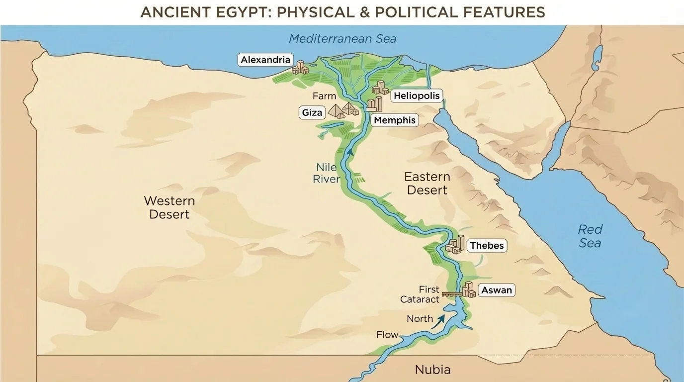
[Figure 2] One of the clearest examples of geography shaping history is ancient Egypt. The civilization of ancient Egypt developed along the Nile River. The surrounding desert made travel difficult and gave Egypt some protection from invasion. Meanwhile, the Nile provided water, transportation, and rich soil left behind by floods.
Because the desert was so dry, most people lived close to the river. Farms, towns, and trade routes lined the Nile. In this case, a physical feature did not just help life; it organized life. It decided where people settled, how they traveled, and how food was grown.
Another important example comes from North America. The Appalachian Mountains affected early movement in the eastern United States. For colonial settlers living along the Atlantic coast, these mountains formed a barrier. Crossing them was possible, but not easy. This slowed westward settlement for a time.
Later, mountain passes and valleys allowed more movement inland. Roads and trails became routes for settlers. Once people crossed the Appalachians, they found broader lands and river systems leading farther west. Geography helped decide the speed and direction of settlement.
The Great Plains also influenced movement and adaptation. The Plains stretched across a wide area with grasslands, fewer trees, and changing weather. Native nations who lived there adapted in ways that fit the environment. They used available animals and plants, traveled over open land, and adjusted to life with fewer forests and different water sources.
The Oregon Trail gives another example. Settlers moving west in the 1800s had to cross plains, rivers, and mountains. Their route was shaped by the landscape. They could not simply go in a straight line. They followed paths that offered water, grass for animals, and passes through rough terrain. Geography did not make the decision for them, but it strongly shaped the journey.
Not all movement happens for the same reason. Some people move by choice to find jobs, farmland, religious freedom, or new opportunities. Others are forced to move because of war, slavery, persecution, or government orders. Understanding the difference helps explain both the cause of movement and its consequences.
Trade is one kind of voluntary movement. Merchants travel where goods can be exchanged. Coastal ports, river cities, and crossroads become busy places because they connect many routes. Explorers also moved through unfamiliar places, often following waterways or coastlines because those routes were easier to navigate than thick forests or high mountains.
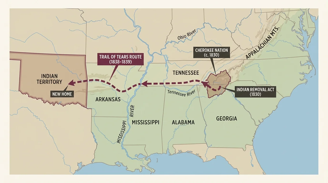
[Figure 3] Forced movement can be especially painful and unjust. The removal of the Cherokee and other Native nations from their homelands is one example. The Cherokee were forced to travel west along what became known as the Trail of Tears. This movement happened because of political decisions, not because the land naturally required it.
Many people suffered from hunger, disease, and exhaustion during the journey. The consequence of this movement was not only loss of land. It was also loss of homes, community ties, and lives. Geography mattered here too, because the long route and difficult conditions made the suffering worse.
Another example of forced movement is the transatlantic slave trade. Africans were taken from their homes and transported across the ocean through the Middle Passage. Coastal locations became important points in this system because ships connected continents. This was a terrible movement of people caused by human choices, greed, and political power.
These examples show that movement can spread ideas and goods, but it can also bring suffering. Historians study who moved, why they moved, what routes they took, and what happened afterward. Routes on a map are not just lines. They represent real human experiences.
Case study: Why did settlers follow certain trails west?
Step 1: Identify the physical features.
Settlers faced rivers, plains, mountains, and dry areas. They needed water, grass for animals, and places where wagons could pass.
Step 2: Identify the political features.
Governments claimed territories, made treaties, and encouraged settlement. Trails also became safer or more dangerous depending on who controlled the area.
Step 3: Connect cause and consequence.
The cause of movement included land and opportunity. The consequences included new towns, conflict with Native peoples, and environmental change.
This is how geographers and historians analyze movement: they look at land, government, and human choices together.
People also move today for many of the same reasons. Families may move because of storms, drought, jobs, or safety. Borders and laws still matter. So do rivers, roads, coasts, and climate zones. The past helps us understand the present.
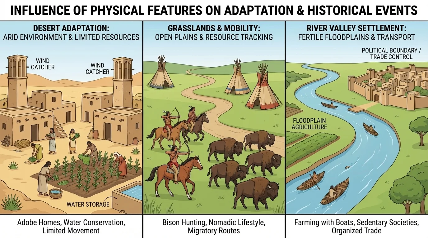
[Figure 4] Humans do not only move through environments; they also change their way of life to fit them. People in different regions choose homes, food sources, and travel methods that match local conditions. Adaptation is one of the most important ideas in geography because it shows how people respond to challenges instead of simply giving up.
In dry regions, people may build thick-walled homes that stay cooler during the day. They may save water carefully and grow crops that need less moisture. In river valleys, people may farm rich soil and use boats to travel. In forested regions, wood may be used for homes, tools, and fuel.
On the Great Plains, where trees were fewer in some areas, people used other materials available to them. Open land made travel and hunting different from life in dense forests. Weather could change quickly, so people needed knowledge of the land and seasons to survive.
Adaptation can also include clothing and transportation. In cold places, people wear heavy layers and build shelter against wind. In snowy regions, different forms of travel may be needed than in warm coastal regions. Where rivers freeze in winter or flood in spring, people must plan carefully.
Food is closely tied to environment too. People often eat what they can grow, hunt, catch, or trade. Along coasts, fish may be important. In fertile valleys, grains and vegetables may be common. In grasslands, herding or hunting may be more important. This is another way physical geography shapes daily life.
Adaptation does not mean the environment controls everything. People invent tools, create irrigation systems, and build roads. But adaptation always begins with understanding the place. This comparison helps us see that people in different environments solve similar problems in different ways.
| Environment | Common Challenge | Possible Adaptation | How Movement Is Affected |
|---|---|---|---|
| River valley | Flooding | Farm near fertile soil and use boats | Travel and trade often become easier |
| Mountain region | Steep land | Use passes and build along valleys | Movement may be slower and more limited |
| Desert | Little water | Settle near oases and conserve water | Routes depend on water sources |
| Plains | Few natural barriers | Travel across open land and follow herds | Movement can cover long distances |
| Coast | Storms and tides | Build ports and use sea travel | Trade and migration can increase |
Table 1. Examples of how different environments create challenges, adaptations, and movement patterns.
Historians and geographers ask questions about place. Why did a town grow here and not there? Why did people move along one route and not another? Why did conflict happen in one region but not in the next? A map helps answer these questions by showing rivers, roads, borders, and settlement patterns.
[Figure 5] A primary source is a record from the time being studied, such as a diary, letter, map, speech, or photograph. A secondary source is something created later, like a textbook or article that explains the past. Both types of sources help us understand movement.
If a diary says a journey was hard, a map can help explain why. Maybe travelers crossed a mountain range. Maybe the route passed through a desert. If a law ordered people to leave an area, political maps help show which government had power there. Geography adds important evidence to historical study.
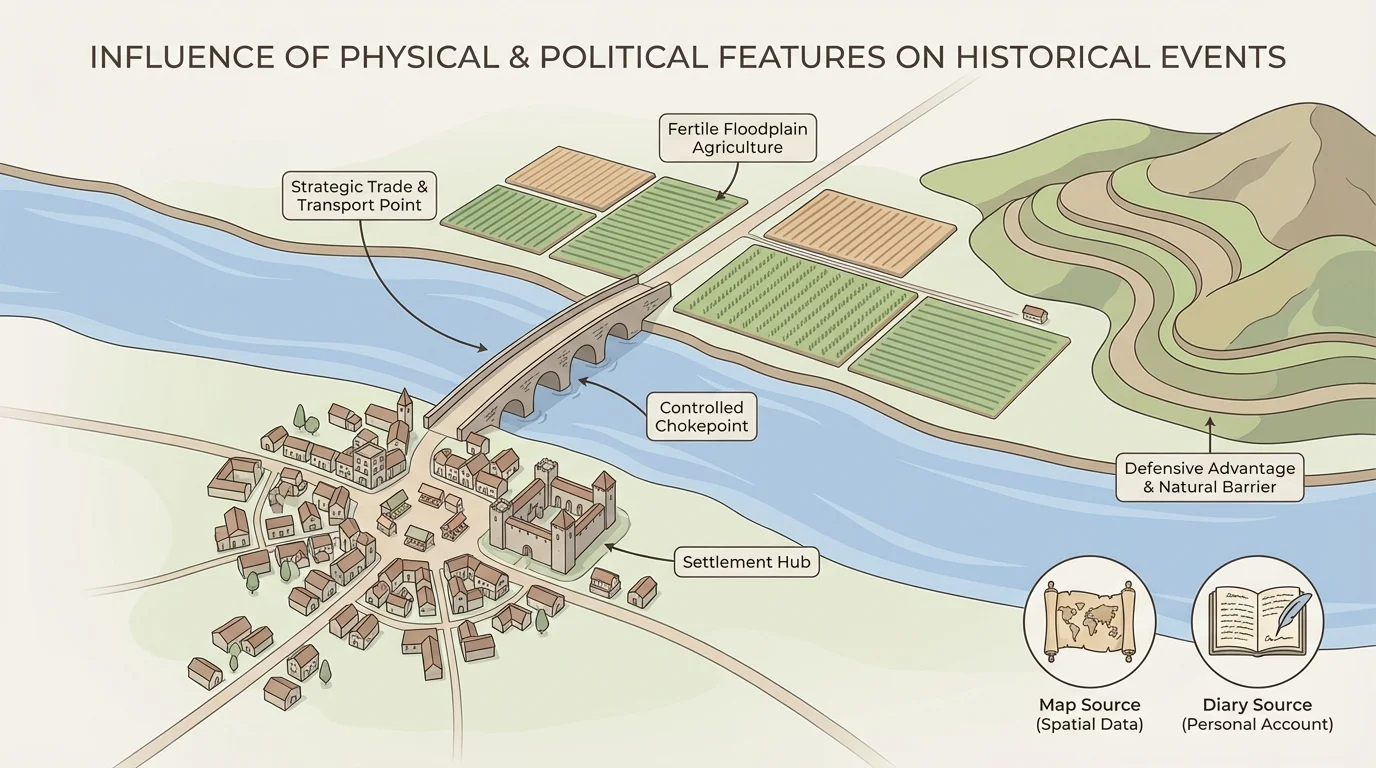
Suppose a settlement grew at a river crossing. A historian might notice that wagons could cross there more easily, traders could meet there, and farms nearby had water. The same place might later become politically important if a government built a fort, road, or courthouse there. This is how physical and political features can work together.
We can see that one place may become important for several reasons at once: natural resources, transportation routes, and political control. Good historical analysis connects all of these factors instead of looking at only one.
Maps do more than show location. They also show patterns. Looking for patterns in rivers, roads, mountains, and borders helps explain why people moved and how events unfolded.
Cause-and-consequence thinking is especially important. A drought might cause movement. A new border might cause trade to slow. A good harbor might cause a city to grow. The consequences may last a long time, shaping culture, economy, and population even centuries later.
History becomes clearer when we place events in order. The examples below show how geography and movement appear across different times and places.
| Time Period | Event or Example | Geographic Importance |
|---|---|---|
| Ancient times | Egypt grows along the Nile River | River water, fertile soil, and desert protection support civilization |
| Colonial era | Settlements grow along the Atlantic coast | Coasts and harbors support trade and travel |
| Early United States | Appalachian Mountains slow westward movement | Mountains act as barriers until passes and trails are used |
| 1800s | Oregon Trail carries settlers west | Routes follow water sources, plains, and mountain passes |
| 1830s | Trail of Tears forces Native removal | Political decisions and long routes create suffering and displacement |
| Modern times | People migrate for safety, jobs, or climate reasons | Physical and political features still shape movement today |
Table 2. A timeline of historical examples showing how geography influenced movement and events.
From ancient river valleys to modern borders, the same big idea remains true: where things are affects what happens. Physical features influence routes, resources, and safety. Political features influence power, law, and control. Together, they help explain major historical events, human movement, and the many ways people adapt to life on Earth.