Why do some places grow into busy cities while others stay small? One major reason is access to resources. Throughout North America and the United States, communities often developed where people could easily reach water, fertile land, forests, minerals, or energy sources. These resources gave people what they needed to live, work, travel, and trade. A tiny settlement near a river or a mine could become a large town over time because the location offered useful resources that were easy to reach.
A resource is something people use to meet their needs or wants. Some resources come from nature, like fresh water, trees, soil, coal, and fish. Others are human-made, like roads, railroads, bridges, and ports. When we talk about accessible resources, we mean resources that people can reach and use without too much difficulty. A resource deep underground or far from transportation may exist, but if people cannot reach it easily, it will not help a community as much.
Communities develop when people find ways to use nearby resources. If a region has rich soil, people may build farms and markets there. If it has a deep harbor, ships can stop there and trade goods. If it has forests, people may build logging camps, sawmills, and towns. If it has oil or coal, workers, businesses, and transportation systems may appear to support those industries.
Accessible resources are useful natural or human-made features that people can reach and use. Accessibility depends on location, transportation, technology, and the physical environment.
Community development is the growth and change of a place as people build homes, businesses, roads, schools, and other parts of daily life.
Accessibility is not just about distance. A river may be nearby, but if it freezes much of the year, it is less useful for shipping. A mountain region may contain valuable minerals, but steep slopes can make travel difficult. Over time, technology such as railroads, canals, highways, and pipelines can make resources more accessible and change how communities grow.
Accessible resources can be grouped into several types. Water resources include rivers, lakes, coasts, and harbors. Land resources include fertile soil, grasslands, forests, and flat land for building. Mineral resources include iron, copper, gold, and other useful materials found in the ground. Energy resources include coal, oil, natural gas, sunlight, wind, and flowing water.
People do not use every resource in the same way. Some resources help communities produce food. Others help with transportation. Others support factories or energy production. In many places, communities grew because several resources came together. A city near a river, with nearby farmland and a good harbor, had many advantages at once.
Location also matters on different scales. A local community may grow because it sits beside a useful river or in a fertile valley. A larger region may become known for farming, fishing, timber, or mining because many communities there share the same resources and landforms.
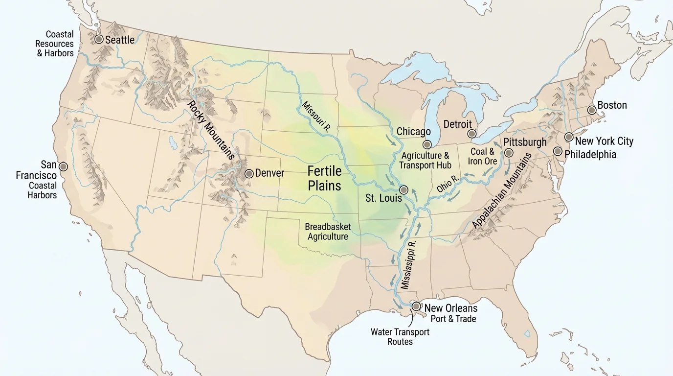
Geographers ask questions such as: Why did people settle here? What resources are nearby? How do landforms and climate affect life? To answer these questions, they compare maps and other sources, as [Figure 1] illustrates. A physical map shows mountains, rivers, plains, and coastlines. A climate map shows temperature and rainfall. A resource map shows where forests, minerals, oil, or farmland are found.
A political map shows states, countries, and cities. When geographers compare a political map with a physical map, they often notice that many major cities are near rivers, coasts, or lakes. This is not an accident. People usually settle where water, transportation, and food sources are easier to find.
Other useful sources include photographs, satellite images, population maps, and historical maps. Historical maps can show how a place changed over time. For example, a town may start near a river crossing, then grow after a railroad is built, and later become a city with highways and industries. Geographic tools help us connect the land to human activity.
When students study geography, they are really studying relationships. They look at where things are, why they are there, and how those locations affect people. A map does more than show places. It helps explain why one area becomes a farming region, another becomes an industrial center, and another remains sparsely populated.
The Great Lakes hold about one-fifth of the world's fresh surface water. That huge water supply helped cities, farms, and factories grow in the surrounding region.
As we continue, keep thinking like a geographer: what natural features are present, which resources are accessible, and how do those features shape people's choices?
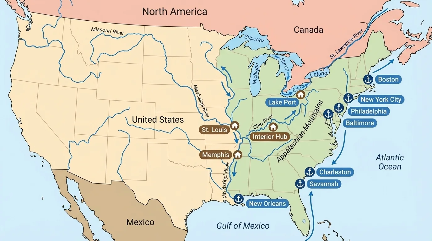
For thousands of years, waterways acted like natural highways, and [Figure 2] shows why communities often formed beside them. Rivers, lakes, and coasts made travel and trade much easier than moving through thick forests or across rough mountains. Before cars and trains existed, moving heavy goods by water was often the fastest and cheapest choice.
Many early communities in North America formed near rivers because people needed fresh water for drinking, farming, cooking, and washing. Rivers also provided fish and transportation. The Mississippi River and its many connected rivers became one of the most important systems for movement and trade in the interior of the United States. Communities along this system could send crops and goods to other places.
The Great Lakes and the St. Lawrence River created another major transportation network. Cities such as Chicago, Detroit, Cleveland, and Toronto grew in part because they connected inland regions to Atlantic trade routes. On the Atlantic coast, ports like Boston, New York, and Charleston grew where ships could safely arrive, load goods, and sail to other markets.
Waterways did not only help large cities. Smaller communities also developed near streams and rivers because moving water could power mills. A mill could grind grain into flour or cut logs into boards. That meant farmers and builders had a reason to live and work nearby.
Later in history, canals increased accessibility even more. The Erie Canal, for example, connected the Great Lakes region to the Hudson River and New York City. This made shipping faster and helped New York become a major trade center. As we can see from the transportation patterns in [Figure 2], one connected water system can influence many communities at once.
Another major reason communities develop is fertile soil. Fertile soil helps crops grow well, which supports farms, towns, markets, and transportation routes. As [Figure 3] shows, broad farming regions in North America often have flat land, useful rainfall, and rich soil all in the same place.
The Great Plains and the Midwest became important farming regions because they had large areas of grassland and productive soil. Farmers grew crops such as wheat and corn and raised livestock. Because farms produce large amounts of food, nearby communities often built grain elevators, rail stations, equipment stores, and food-processing businesses.
California's Central Valley is another strong example. Its fertile soil and warm climate help farmers grow many fruits, vegetables, and nuts. Water systems, including rivers, reservoirs, and canals, make this farming possible in many areas. Towns and cities in the valley developed because agriculture created jobs, trade, and transportation needs.
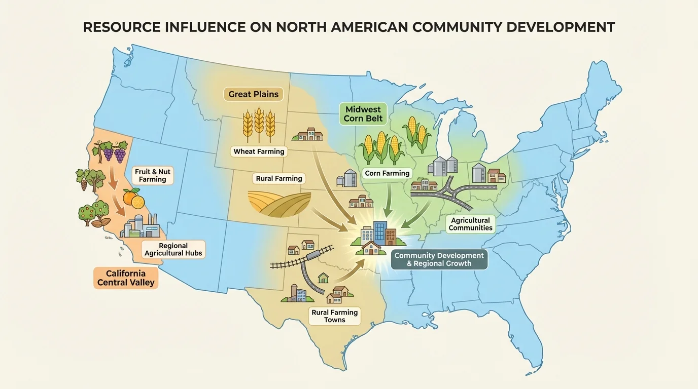
Good farming land can influence an entire region. When many farms are located close together, roads, markets, warehouses, and shipping centers appear. Schools, stores, and homes grow around them. This is one reason the Midwest became known as a major agricultural region of the United States.
Case study: Farming and town growth in the Great Plains
Step 1: Settlers identified large areas of flat grassland with soil that could support crops.
Step 2: Farmers planted wheat and other crops, which produced food for local use and for sale.
Step 3: Railroads connected farms to distant markets, making the land even more valuable.
Step 4: Towns grew near rail stops because workers needed homes, stores, schools, and services.
This pattern shows how natural resources and transportation together can shape a whole region.
The farming regions in [Figure 3] also remind us that climate matters. Land may be flat, but if it is too dry, too cold, or too rocky, farming is much harder. Geographers always connect soil, climate, water, and transportation when studying where communities develop.
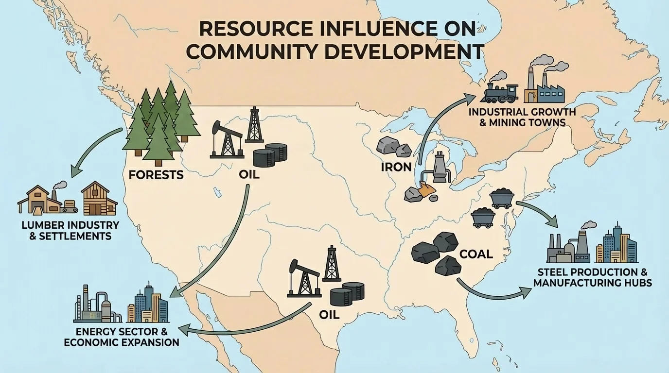
Some communities grew because valuable materials were found nearby, and [Figure 4] highlights several major examples. Forests provided timber for building houses, ships, furniture, and later paper products. Mineral and energy resources such as iron, coal, oil, and natural gas supported mining, manufacturing, and transportation.
The Pacific Northwest became known for its large forests. Timber helped local economies grow, and towns developed around logging, sawmills, and shipping. In eastern North America, especially in the Appalachian region, coal mining shaped many communities. Coal powered factories, trains, and electricity generation during important periods of industrial growth.
Iron ore near the Great Lakes helped industries in places such as Pittsburgh, Cleveland, and Detroit. When iron and coal could be transported to factories, steel production increased. Steel was used for bridges, railroads, buildings, and machines. In Texas and parts of western Canada, oil and natural gas supported the growth of drilling towns, refineries, and pipeline systems.
These resource-based communities often depended on one main industry. That could bring jobs and wealth, but it could also create problems if the resource became harder to find or less important. A mining town might shrink if the mine closed. A timber town might change if forests were protected or logging decreased.
The resource patterns shown in [Figure 4] help explain why different parts of North America developed different kinds of communities. Regions rich in forests often built lumber industries, while areas with coal or oil developed energy and manufacturing connections.
Landforms do more than provide resources. They also affect accessibility. Mountains can contain minerals, forests, and fresh water, but they can make travel harder. The Appalachian Mountains affected movement in early American history because crossing them was difficult. Settlers used gaps and passes where travel was easier.
The Rocky Mountains also influenced development. Some communities formed because mountain valleys offered water and protection, while others formed near mining areas. However, steep slopes and harsh winters limited growth in many places. In geography, a place may be resource-rich but still hard to settle if the land is difficult to cross.
Flat plains often make travel, building, and farming easier. That is one reason large agricultural communities developed across broad central areas of North America. In contrast, deserts and high mountains often have fewer large settlements because water is limited and transportation can be challenging.
Resources and barriers work together
A place does not grow just because it has a resource. Geographers also ask whether people can reach it, move goods from it, and build around it. A mountain region may have copper or gold, but roads, rail lines, or passes are needed before large communities can grow there.
This is why transportation routes matter so much. Roads through mountain passes, bridges across rivers, and tunnels through hills can change a region by making resources easier to use.
North America is large, so communities did not all develop the same way. The Arctic has rich resources such as fish, oil, and minerals, but cold temperatures and long distances make access difficult. Communities there are often smaller and more spread out.
In the Great Lakes region, fresh water, transportation routes, and nearby minerals helped create major industrial and trading cities. In the Great Plains, grasslands and fertile soil supported agriculture and ranching. In the Southwest, limited water shaped settlement patterns, so communities often developed near rivers, groundwater, or irrigation systems.
The Pacific Coast has excellent harbors, fishing resources, forests, and trade access across the Pacific Ocean. Cities such as Seattle, Vancouver, Los Angeles, and San Francisco grew because they connected ocean trade with inland resources and transportation networks. On the Gulf Coast, ports, fishing, and energy resources such as oil and natural gas strongly influenced development.
| Region | Important Accessible Resources | How Communities Developed |
|---|---|---|
| Great Lakes | Fresh water, transportation, nearby iron | Ports, factories, trade cities |
| Great Plains | Fertile soil, grasslands | Farms, ranches, rail towns |
| Appalachia | Coal, forests | Mining and timber towns |
| Pacific Northwest | Forests, harbors, rivers | Logging, shipping, port cities |
| Southwest | Minerals, sunlight, limited water | Settlements near water and mining areas |
| Gulf Coast | Ports, fish, oil, natural gas | Trade centers and energy communities |
Table 1. Examples of how accessible resources influenced community development in different North American regions.
These regional differences show an important geography idea: the environment helps shape human activity, but people also change the environment. Irrigation can support farming in dry places. Dams can create reservoirs. Ports can deepen harbors. Technology can make difficult places more connected than before.
Communities are not frozen in place. They change when new transportation systems appear, when technology improves, or when the value of a resource changes. A town that began as a river port might later become a railroad center, then a highway city, and later a place known for business or tourism.
Railroads were especially powerful in the United States and Canada because they connected inland resources to distant markets. They made farms, forests, and mines more valuable by helping people ship goods faster. Highways and airports later changed development again by allowing faster movement of people and products.
Resources can also become less important. Some coal towns declined when other energy sources became more common. Some fishing communities faced problems when fish populations dropped. On the other hand, regions with strong sunlight or wind are now developing new energy industries. This shows that accessibility includes not just location, but also what people are able and willing to use at a certain time.
Earlier geography learning helps here: people settle where they can meet their needs. Water, food, transportation, and safety are basic needs that strongly influence where communities begin.
Conservation also matters. If forests are cut too quickly or water is overused, communities may face long-term problems. Smart planning helps regions use resources while protecting them for the future.
Accessible resources often bring many benefits. They can provide jobs, food, trade, transportation, and energy. They can support schools, hospitals, roads, and other services because growing communities usually collect more money from businesses and workers.
But growth also creates challenges. Factories and mining can pollute air and water. Rapid growth can lead to crowded cities, traffic, or habitat loss. Some communities may gain wealth while others are left out if they do not have equal access to transportation or important resources.
There can also be conflict over how resources should be used. One group may want to drill for oil, while another wants to protect wildlife or water quality. Geography helps us understand these choices because it asks how places, people, and resources are connected.
"Geography is not just where things are. It is why they are there and how that matters to people."
When geographers study a region, they look at both the opportunities and the costs. A river can bring trade and power, but it can also flood. A forest can supply timber, but too much logging can damage ecosystems. Good decisions require understanding the whole picture.
To describe the influence of accessible resources, a geographer gathers evidence from maps, photographs, charts, and historical records. Then the geographer asks questions: What resources are nearby? How easy are they to reach? What landforms help or block movement? How did people adapt over time?
For example, if you see a large city beside a river and near a coast, you might predict that trade helped it grow. If you see many small towns across fertile plains, you might predict that farming shaped the region. If you see settlements near mountain mining areas, you might connect community growth to minerals and transportation routes.
Across North America and the United States, accessible resources have strongly influenced where people live and how communities develop. Waterways helped people travel and trade. Fertile soil supported farming regions. Forests, minerals, and energy sources created industrial and resource-based towns. Landforms could either help or limit growth. By using geographic tools and sources, we can better understand why communities look the way they do today.