A river can be a highway, a border, a food source, or a military target—all at the same time. That is one reason geography matters so much in history. In early American history, people fought not only because they disagreed, but because they looked at the same land and saw completely different things. One group saw hunting grounds and sacred places. Another saw farmland. Another saw a trade route. Another saw a chance to build an empire.
When historians compare events, they often ask who was involved and what happened. Geographers ask another important question: where did it happen, and how did the location shape people's choices? A geographic perspective is a way of understanding a place based on how people use it, value it, and connect to it. Different geographic perspectives can lead to cooperation, misunderstanding, or conflict.
In early North America, geography shaped almost everything. Mountains affected travel. Rivers connected distant communities. Forests provided timber and fur-bearing animals. Fertile valleys drew settlers. Coastal harbors encouraged trade. Because land and resources were limited in some areas and extremely valuable in others, many groups competed for control.
Geographic perspective means how a person or group understands a place based on its location, features, resources, and importance to their goals.
Resources are useful materials people depend on, such as land, water, timber, furs, fish, and fertile soil.
Territory is land that a group uses, occupies, claims, or controls.
Looking at history through geography helps us avoid a simple story of "one side versus another." The same valley might be a homeland to one nation, a hunting zone to another, and a strategic corridor to an empire. Those differences matter because they shape decisions, alliances, and wars.
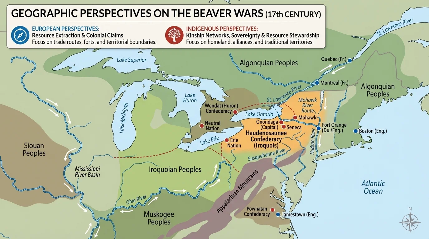
Long before European empires claimed parts of North America, Native American nations had rich knowledge of land, seasons, and travel routes. Across eastern North America, communities understood how rivers, forests, plains, and mountain passes connected regions, as [Figure 1] shows in the major routes and environmental zones. Land was not "empty." It was lived on, managed, hunted, farmed, and traded across.
Different Native groups used land in different ways. Some practiced large-scale farming of crops such as corn, beans, and squash. Others depended more heavily on hunting, fishing, and seasonal movement. Many did both. This meant that territory was often understood through use, relationships, and shared access rather than through sharply drawn border lines like those on many European maps.
Native trade networks stretched across huge distances. Shells from the Atlantic coast, copper from the Great Lakes region, and other goods moved along rivers and overland paths. These networks were geographic systems. They relied on knowledge of waterways, canoe routes, portages, and seasonal conditions. Control over these routes could bring power, wealth, and influence.
Another important difference was the meaning of land itself. For many Native nations, land was tied to community life, spiritual beliefs, and survival. Forests and rivers were not just resources in an economic sense. They were parts of a living environment connected to identity and responsibility. This does not mean Native groups never fought over land—they did—but their ideas about land ownership often differed from European legal ideas about private property and permanent boundaries.
Some of the most important early American roads began as Native trails. European settlers and later American governments often built on routes that Native peoples had already mapped through experience.
That deep geographic knowledge gave Native nations important advantages in diplomacy and warfare. They knew where food could be found, which rivers allowed fast travel, and which mountain gaps could be defended. As later conflicts grew, this knowledge became a major factor in who could move, trade, and survive.
European empires did not all approach North America in the same way. The Spanish focused heavily on controlling territory in the South and West, spreading Christianity, and gaining wealth from land and labor. The French built strong networks in the St. Lawrence River valley, the Great Lakes, and the Mississippi basin, where trade—especially the fur trade—became central. The English established colonies mostly along the Atlantic coast and increasingly pushed inland in search of farmland and settlement space.
The location of a colony often depended on coastal geography. Good harbors made trade easier. Rivers allowed ships and goods to move inland. Mild climates and fertile soil encouraged settlement. Over time, English colonies grew rapidly in population. That growth increased demand for land, especially for farming and later for plantation agriculture in the South.
These imperial goals created very different geographic strategies. French leaders often depended on alliances with Native nations and established forts along river systems. English colonists, by contrast, more often moved families onto land and created permanent farms, towns, and property lines. That pattern made conflict over territory more likely because settlers usually stayed and expanded.
Why rivers mattered so much
In early American history, rivers were like major highways. They moved people, crops, trade goods, and armies. A group that controlled an important river could influence trade and military movement over a wide area. This is one reason river valleys became centers of both cooperation and conflict.
European maps also reflected a different way of seeing space. Empires often drew large claims on paper long before they actually controlled the land. A king in Europe might claim an enormous region, but local people on that land might not recognize that claim at all. This difference between mapped claims and lived control is one of the most important ideas in historical geography.
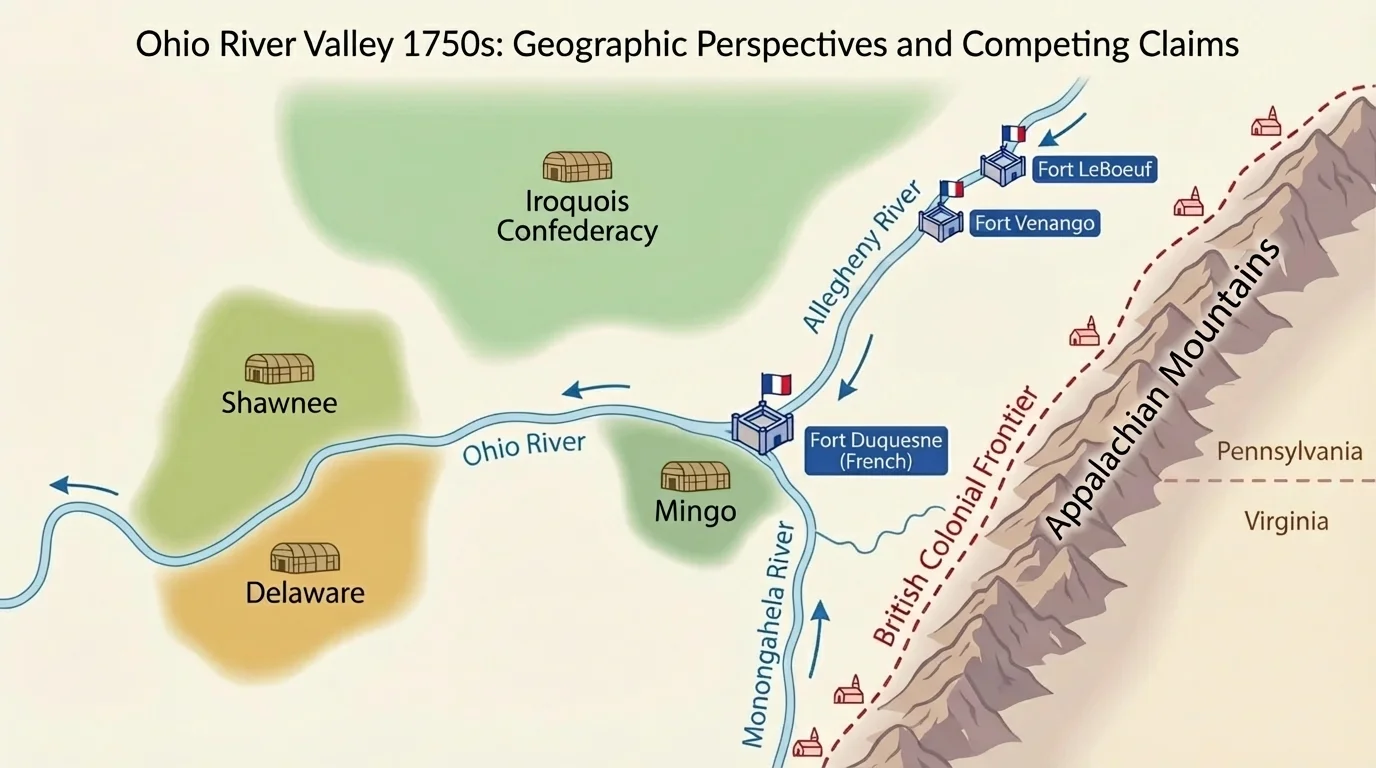
One of the clearest examples of differing geographic perspectives is the struggle over the Ohio River Valley. This region lay between the British colonies on the Atlantic coast and French territories linked by the Great Lakes and the Mississippi River. To Native nations already living in and around the region, the valley was not an empty space waiting to be claimed. It was a homeland, a hunting ground, and a crossroads of trade, as [Figure 2] illustrates through overlapping routes and claims.
From the French point of view, the Ohio Valley was the key link in a giant north-south network. If France controlled the St. Lawrence River, the Great Lakes, the Ohio country, and the Mississippi River, it could connect Canada to Louisiana. That made the valley strategically valuable even if French settlement there remained limited.
From the British colonial point of view, the valley looked like opportunity. Colonists on the Atlantic seaboard faced a barrier: the Appalachian Mountains. But population growth and land hunger pushed many settlers to look west. Land companies hoped to survey, divide, sell, and farm western territory. To them, the Ohio Valley represented future settlement and profit.
For Native nations such as the Shawnee, Delaware, Miami, and others, the valley had a different meaning. It was part of a larger regional world shaped by villages, seasonal movement, diplomacy, and trade. Native leaders often tried to maintain balance between French and British power. Some formed alliances for practical reasons, but many sought to protect their own independence rather than simply choosing a European side.
The conflict sharpened because each group used a different geographic logic. The French emphasized routes and forts. British colonists emphasized settlement and property. Native nations emphasized use, sovereignty, and survival. These were not small differences. They affected how people negotiated treaties, built forts, and interpreted "ownership."
Geography on the ground mattered too. The Ohio River system connected many smaller rivers and streams. Anyone controlling forts near river junctions could influence movement across the interior. Fort Duquesne, near the meeting of rivers that form the Ohio, became important because it stood at a strategic point rather than simply on "valuable land" in a farming sense.
The same region also contained forests rich in fur-bearing animals, good farmland in some valleys, and access to broader interior trade. That combination of transportation and resources made the area especially contested. In other words, the conflict was not just about land in general. It was about specific kinds of land in a specific location.
To understand why this conflict grew, it helps to look at major physical features. The Appalachian Mountains formed a partial barrier between the Atlantic colonies and the interior. They did not make movement impossible, but they slowed large-scale settlement. River valleys and mountain gaps became critical routes through or around this obstacle.
The Great Lakes and the St. Lawrence River gave the French access to a vast inland network. The Mississippi River connected northern territories to the Gulf of Mexico. British port cities such as Boston, New York, Philadelphia, and Charleston linked the colonies to the Atlantic world. Each empire's geography supported different strengths.
As seen earlier in [Figure 1], eastern North America worked as an interconnected set of waterways and ecological regions rather than as isolated places. That is why the location of one fort or one river junction could affect diplomacy across a much wider region.
| Geographic Feature | Why It Mattered | Who Saw It as Important |
|---|---|---|
| Ohio River system | Trade, travel, military movement | French, British, Native nations |
| Appalachian Mountains | Barrier and boundary to westward settlement | British colonists, imperial officials |
| Great Lakes | Connection to fur trade and northern forts | French, Native allies |
| Fertile valleys | Farming and settlement | British colonists |
| Forest resources | Hunting, furs, timber | Native nations, French traders, settlers |
Table 1. Major geographic features that shaped competition for land and resources in early American history.
A geographic perspective also includes scale. A local farmer might care most about nearby fields and streams. A Native leader might think in terms of a regional homeland and alliance network. A French official might think about connecting an empire across thousands of miles. A British investor might focus on land sales and settlement. Different scales lead to different priorities.
These conflicts developed over time rather than appearing all at once, as [Figure 3] displays in the sequence from imperial rivalry to new British control after 1763. Geographic perspectives changed as populations grew, forts were built, alliances shifted, and empires won or lost wars.
In the early contact period, European powers depended heavily on Native knowledge and alliances. During the 1600s and early 1700s, trade networks expanded and rival empires competed indirectly through diplomacy, commerce, and frontier settlements. By the mid-1700s, however, the Ohio Valley had become a flash point.
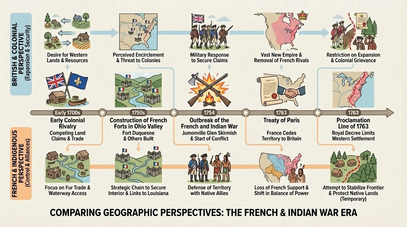
The French and Indian War began in North America in 1754 as Britain and France fought over territory and influence. Native nations joined different sides for different reasons, often based on local interests and survival. In 1763, Britain defeated France and gained control of much of France's North American territory.
But British victory did not solve the geographic problem. Native nations still lived on and used the land, and British colonists still wanted to move west. British officials issued the Proclamation of 1763, which tried to limit colonial settlement west of the Appalachian Mountains. From London's perspective, this line might reduce conflict and lower military costs. From the perspective of many colonists, it blocked access to land they believed they had earned or had a right to settle.
Case study: one land, three different meanings
Consider the same stretch of land in the Ohio Valley.
Step 1: A Native nation views it as part of a homeland connected to nearby villages, hunting grounds, and alliance relationships.
Step 2: A French officer views it as a strategic route where a fort can protect trade and connect distant territories.
Step 3: A British settler views it as fertile land for a farm and a place where a family can build a permanent future.
All three perspectives are geographic, but they lead to very different actions and conflicts.
The aftermath of 1763 helped set the stage for later tensions between Britain and its colonies. Geography remained part of the story. Colonists resented limits on westward movement, while imperial leaders worried about defending a vast frontier. Different perspectives on space and control continued to shape politics.
Historical comparison becomes clearer when we line up the viewpoints. This is not about deciding that one group "used geography correctly" and another did not. It is about recognizing that geography is interpreted through needs, beliefs, and power.
| Group | How Land Was Viewed | Main Geographic Goal | Important Resources or Routes |
|---|---|---|---|
| Native nations | Homeland, shared-use territory, spiritual and economic space | Protect sovereignty, trade, and survival | Rivers, forests, hunting grounds, village networks |
| French empire | Strategic corridor linking empire | Control trade routes and alliances | Great Lakes, Ohio River, Mississippi River, forts, fur regions |
| British colonists | Settlement land and private property | Expand farms, towns, and land claims | Fertile valleys, western lands, mountain passes |
| British imperial government | Managed territory within an empire | Maintain order and reduce costly frontier wars | Boundaries, frontier lines, transport routes |
Table 2. Comparison of geographic perspectives during competition for land and resources in early American history.
As [Figure 2] makes clear, maps can display overlapping claims, but they do not automatically settle whose claim is legitimate. A map drawn in Paris or London might ignore Native political boundaries. A colonial survey might describe parcels for sale while overlooking how local communities used the land seasonally. That is why historians must ask who made the map and for what purpose.
To compare geographic perspectives, historians use both primary and secondary sources. Primary sources are materials from the time period itself, such as treaties, letters, official maps, speeches, and travelers' accounts. Secondary sources are later interpretations written by historians.
A treaty might show how one empire described territorial control. A Native speech might reveal concerns about settlement and broken promises. A military map might emphasize forts and rivers. A historian's book might compare all of these and explain how geography shaped the conflict.
"Maps are not just pictures of places. They are arguments about space, power, and control."
— A key idea in historical geography
When reading sources, students should ask several questions. What land is being described? Who benefits from this description? What features are highlighted—rivers, farms, borders, forts, villages? What is left out? These questions help uncover perspective.
For example, a British colonial map might focus on surveyed boundaries and available settlement land. A French record might focus on waterways and forts. Native oral traditions and diplomatic statements might focus on relationships, use, and responsibility. Each source tells us something important, but none gives the whole picture by itself.
This topic is not only about the past. Around the world today, people still disagree about borders, natural resources, pipelines, forests, and water rights. A company may see a region as a source of profit. Local residents may see it as home. Governments may see it as strategic territory. Those are geographic perspectives too.
The lesson from early American history is that land is never just land. It carries economic value, cultural meaning, political power, and environmental importance. When groups compete for control of land and resources, conflict often grows from these different ways of seeing place.
Even the same map can tell different stories depending on who reads it. As we saw in [Figure 3], events such as war and treaties may change official boundaries quickly, but people's connection to the land does not disappear overnight. Geography shapes conflict, but it also shapes memory, identity, and the long-term consequences of historical change.