Why do so many of the world's biggest cities sit near coasts, rivers, or major transportation routes? That is not an accident. If you look at a map of where people live, work, trade, and travel, you begin to see that human settlement follows patterns. These patterns reflect both opportunity and constraint: fertile soil, safe harbors, highways, jobs, political decisions, and even past migrations all leave visible marks on the landscape.
Geography studies those marks by asking where things are, why they are there, and what happens because of that arrangement. A settlement can be as small as a rural hamlet or as large as a megacity. Some settlements are tightly grouped, others are spread far apart, and many align along roads, rivers, railroads, or coastlines. Human activities such as trade, farming, manufacturing, and the use of technology also spread through space, a process geographers call diffusion.
To understand settlement patterns, geographers connect multiple variables at once: physical geography, transportation, economics, culture, politics, and history. A city may grow because it has a good harbor, but it may keep growing because it becomes a financial center, receives migrants, and gains new transportation links. In geography, places are never isolated; they are shaped by interaction.
A settlement is a place where people live and build community. Geographers study not only the settlement itself but also its site and situation. Site refers to the physical characteristics of the place itself, such as elevation, water access, climate, or soil. Situation refers to the place's relative location compared with other places, such as proximity to markets, ports, borders, or transportation routes.
Site means the physical features of a location itself, such as a riverbank, valley floor, natural harbor, or flat plain.
Situation means the location of a place in relation to other places, such as being near trade routes, major cities, or natural resources.
Distribution describes how settlements are spread across an area, while arrangement describes the pattern they form, such as clustered, linear, or dispersed.
Geographers also measure population density, which compares the number of people to the amount of land. Density helps explain why a city-center neighborhood feels very different from a farming region. Dense settlement usually means more buildings, services, and infrastructure in a smaller area, while low density often means greater distance between homes, workplaces, and services.
Another useful idea is spatial pattern. This means the visible arrangement of people or features on the landscape. When geographers analyze spatial patterns, they are looking for relationships: Are settlements close to rivers? Do they form corridors along highways? Do they become larger where transportation routes intersect?
One of the first things geographers notice is that settlements are not randomly placed. They form recognizable patterns, as [Figure 1] illustrates, and each pattern suggests something about the environment and the economy. A clustered pattern often appears where people gather around a resource, market, or service center. A dispersed pattern often appears in farming regions where families live on separate plots of land. A linear pattern often develops along roads, rivers, coastlines, or valleys.
A clustered or nucleated settlement pattern places homes and buildings close together. This pattern is common where defense, trade, or social cooperation matters. Older European villages often formed this way, with homes gathered around a church, market square, or water source. In modern cities, clustering can also occur because businesses benefit from being near one another, a process called agglomeration.
A dispersed settlement pattern spreads homes or farms over a wide area. This is common in agricultural regions of the United States, Canada, and Australia, where mechanized farming and large landholdings reduce the need for tightly packed villages. People may travel farther for school, shopping, or health care because daily life is organized across larger distances.
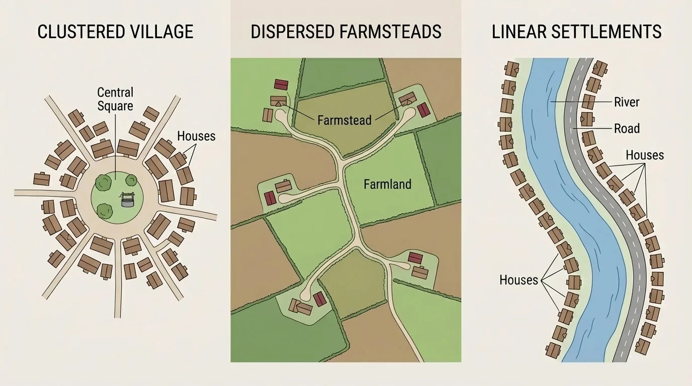
A linear settlement pattern develops along a transportation route or physical feature. Settlements in the Nile Valley are a classic example. Because the surrounding desert is so dry, most communities line the narrow band of fertile land near the Nile River. Similar patterns appear along mountain valleys, coastlines, and major highways.
Some settlements also follow a grid arrangement, especially in planned cities. Many cities in the Americas were designed with streets crossing at right angles, which makes navigation and land division easier. Other urban areas developed more irregular street patterns because they grew gradually over centuries rather than from a single plan.
These arrangements matter because they affect access. In a clustered village, services may be easy to reach on foot. In a dispersed farming area, residents may depend heavily on cars or buses. In a linear settlement, movement may be efficient along the main route but limited away from it. The visible pattern tells a story about both the past and the present.
The contrast between city and countryside is one of the clearest geographic patterns. Urban areas usually have high density, tall buildings, concentrated services, and diverse economic functions, while rural areas usually have lower density, more open land, and stronger ties to farming, forestry, mining, or tourism. That contrast appears clearly in land use and in how people move through daily life.
Urbanization is the growth of the proportion of people living in towns and cities. It often happens as industrialization creates factory jobs, service jobs, and transportation links. Over time, the urban core may be surrounded by suburbs, industrial zones, shopping districts, and commuter belts. Rural areas, by contrast, tend to have fewer services and greater distances between major destinations.
Urban settlements often develop around nodes, which are strategic points of connection such as ports, rail junctions, highway intersections, or airport zones. As [Figure 2] shows, once a node becomes important, businesses and residents are drawn to it. This can create a cycle: more people attract more services, and more services attract more people.
Rural settlements are shaped strongly by land use. In an area of large commercial farms, homes may be widely spaced. In a region of small-scale farming, villages may be more compact because farmers can walk or bike to nearby fields. Rural patterns also depend on topography. Mountain villages often cluster in valleys, while settlements on plains can spread more freely.
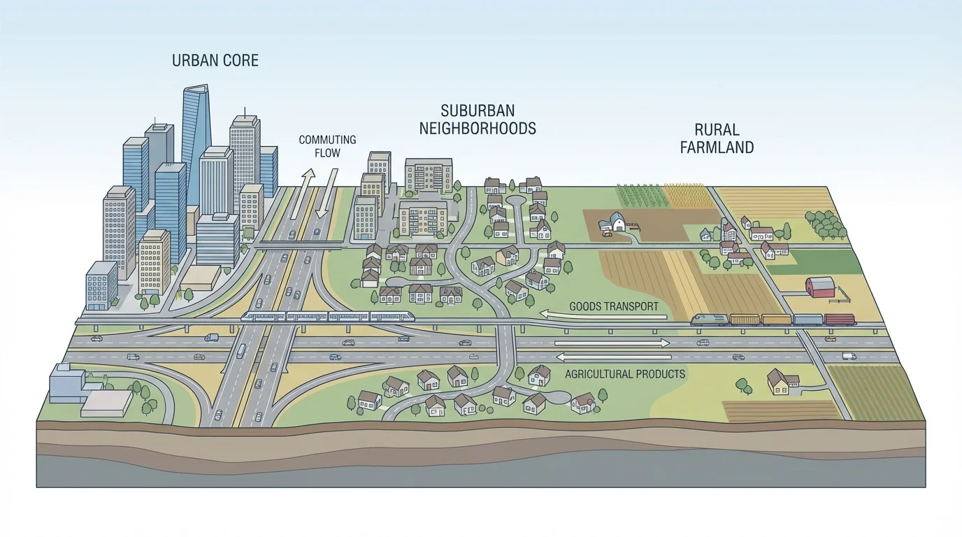
The boundary between urban and rural is not always sharp. Many regions include suburban and peri-urban zones where farmland, housing developments, warehouses, and shopping centers mix together. This is common on the edges of large metropolitan areas. As cities expand outward, they may absorb nearby towns into a wider metropolitan region.
Urban-rural interaction involves constant movement of people, goods, money, and ideas. Rural areas send food, raw materials, labor, and energy toward urban markets, while cities provide specialized services, manufactured goods, education, finance, and technology. The two are connected rather than separate worlds.
This interaction also creates inequalities. Urban residents may have easier access to hospitals, universities, and high-speed internet, while rural residents may have more land, lower housing costs, and closer contact with natural resources. Geographers study these differences because they shape quality of life and political decision-making.
When geographers zoom out from a single town to an entire region, larger patterns become visible. Regions differ because of climate, landforms, water supply, natural resources, historical settlement, political power, and cultural traditions. A desert region, a river valley, and an industrial coast will not have the same settlement pattern because they offer different opportunities and constraints.
Physical geography matters first. Flat plains are usually easier to farm, build on, and connect with roads and railways than steep mountains are. Water is especially important. River valleys, lake shores, and coastal plains support dense populations because they offer drinking water, irrigation, transport, and trade routes. Dry interiors or extremely cold regions usually have fewer and smaller settlements.
Economic geography matters just as much. Coalfields helped cities grow in parts of Britain, Germany, and the eastern United States during industrialization. Oil has influenced settlement in parts of the Persian Gulf. Technology corridors such as Silicon Valley in California developed because of a different mix of factors: universities, investment capital, skilled labor, and innovation networks rather than raw materials alone.
History leaves patterns on the map too. Colonial settlement often began near coasts because ships carried people and goods across oceans. In many countries, the earliest large cities formed on navigable rivers or coastlines, then transportation improvements gradually opened inland areas. Political decisions also shape regional patterns, as seen when governments build new capitals, dams, highways, or rail systems.
Brazil provides a strong example. For much of its history, Brazil's largest settlements clustered along the Atlantic coast, where colonial trade and later industrial activity were strongest. The inland capital of Brasília was built in the twentieth century partly to encourage development toward the interior. That decision did not erase coastal concentration, but it changed regional connections and growth patterns.
More than half of the world's population lives in urban areas today, but the exact pattern varies sharply by region. Some regions have giant coastal megacities, while others still have mostly small towns and rural villages linked by local roads and markets.
Regional settlement patterns can also reveal inequality. In some countries, one dominant city contains a very large share of population, wealth, and political power. In others, several medium-sized cities share regional influence. Geographers compare these patterns to understand access to jobs, transportation, education, and government services.
Transportation is one of the strongest forces shaping where settlements grow. Roads, rivers, railways, ports, and airports direct the movement of people, goods, and information. Settlements tend to expand where movement is easiest, and transport corridors often become growth corridors. A place that sits at a crossroads can become far more important than a place with similar land but weaker connections.
A transportation corridor is a route along which movement is concentrated. As [Figure 3] shows, highways, rail lines, and major river systems often create these corridors. Businesses prefer these routes because transportation costs are lower and access to markets is better. Over time, warehouses, suburbs, service centers, and industrial parks may line the corridor.
Ports are classic examples of transportation influence. Cities such as Rotterdam, Shanghai, and New York developed major economic importance because they connect inland regions to global trade. River ports such as St. Louis historically gained importance because they linked agricultural and industrial regions. Airports now play a similar role for high-value goods, tourism, and business travel.
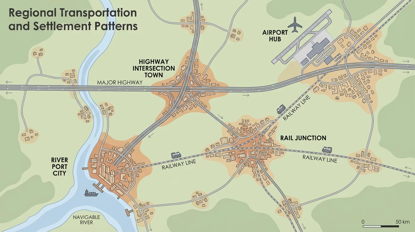
Transportation networks also create hubs and hierarchies. A small town may connect nearby farms to a larger regional city, which in turn connects to a national capital or international port. This layered pattern helps explain why some places offer only basic services while others provide specialized hospitals, universities, or financial institutions.
The United States offers a clear regional example in the BosWash corridor, the urbanized belt stretching roughly from Boston to Washington, D.C. This corridor contains dense settlement, multiple major cities, extensive highways and rail systems, and many overlapping economic functions. It shows how transportation and urban growth reinforce each other over time.
Transportation change can also redirect settlement. When a new interstate highway bypasses an older town center, businesses may move closer to highway exits. When rail service declines, former rail towns may shrink. When a new transit line opens in a metropolitan area, higher-density housing and retail may appear near stations. Accessibility is power in geographic space.
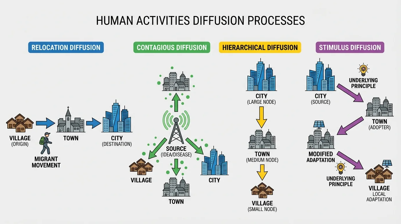
Settlements do not just sit in place; the activities within them spread. Geographers use the term diffusion to describe how ideas, technologies, crops, religions, diseases, languages, fashions, and economic practices move across space. The spread may follow transportation routes, migration streams, trade links, media networks, or social hierarchies.
Relocation diffusion happens when people move and carry an activity with them. Migration spreads languages, foods, beliefs, and skills. For example, immigrants may introduce new cuisines or business practices to the cities where they settle. The activity appears in a new location because people physically relocate.
Expansion diffusion happens when an activity spreads outward from a source while remaining strong there. As [Figure 4] shows, this broad category includes several forms. In contagious diffusion, spread moves rapidly from person to person or place to nearby place, like a viral dance trend on social media or the spread of a disease. In hierarchical diffusion, spread moves first among influential people or major centers, such as fashion trends moving from global cities to smaller cities and towns.
Stimulus diffusion occurs when the underlying idea spreads, but it is adapted to fit local conditions. A business model, agricultural method, or music style may be changed rather than copied exactly. This reminds us that diffusion is not simple copying; places often reshape what they receive.
Transportation and communication strongly affect diffusion speed. A new technology may spread slowly in remote areas with limited connectivity but very rapidly in highly networked urban regions. Social factors matter too. Education, income, language, government policy, and cultural acceptance all influence whether an idea is adopted.
Case study: Mobile banking diffusion in East Africa
Mobile money services spread quickly in parts of East Africa because many people had mobile phones even where traditional banking services were limited.
Step 1: Identify the starting conditions.
Large numbers of people needed safe, fast ways to send money, but bank branches were not equally available in all settlements.
Step 2: Trace the network.
Telecommunications infrastructure and agent locations created a practical pathway for the service to spread from urban centers into smaller towns and rural communities.
Step 3: Explain the diffusion type.
The spread combined hierarchical diffusion through important urban centers and expansion diffusion through everyday social use.
This example shows that human activities spread most successfully when they match local needs and existing networks.
The same logic applies to farming, manufacturing, tourism, and retail. A new crop may spread along climate zones and market routes. A factory system may cluster where labor, transport, and energy are available. A tourism industry may expand where improved roads make scenic or historic places easier to reach. Human activities diffuse through both landscape and society.
The Nile Valley demonstrates how environment can dominate settlement arrangement. Most of Egypt's population lives near the Nile because fertile land and reliable water are concentrated there. The resulting linear settlement pattern reflects a simple but powerful geographic fact: in a desert region, life follows water. This is the same kind of logic discussed earlier, where linear settlements align with narrow usable space.
The BosWash corridor shows what happens when dense population, industry, services, and transportation all reinforce one another. Instead of one single city, it is a chain of interconnected metropolitan areas. This pattern reveals the importance of corridors, nodes, and high accessibility, much like the network described earlier.
China's eastern seaboard offers another major regional pattern. Coastal provinces gained early advantages from trade, ports, manufacturing investment, and global market access. Inland regions have grown too, especially with new transport and development policies, but the strongest concentration has long been in the east. Here again, situation matters as much as site.
In the United States and Canada, prairie and plains regions often display dispersed rural settlements linked to market towns. Mechanized agriculture, large land parcels, and road networks support this pattern. By contrast, mountain regions may have more isolated pockets of settlement because terrain limits both farming and transportation.
| Pattern or Process | Main Geographic Cause | Typical Example | Effect on Human Activity |
|---|---|---|---|
| Clustered settlement | Need for markets, defense, or services | Traditional village center | Shorter travel distances within the settlement |
| Dispersed settlement | Large farm plots and low density | Great Plains farmsteads | Greater dependence on roads and vehicles |
| Linear settlement | River, road, coast, or valley alignment | Nile Valley communities | Development concentrates along a narrow route |
| Urban corridor | Strong transport and economic integration | BosWash | High mobility, trade, and service specialization |
| Hierarchical diffusion | Influence of major centers | Fashion from global cities | Ideas spread unevenly by rank and influence |
Table 1. Comparison of common settlement patterns and diffusion processes with their causes and effects.
Geographers rely heavily on maps, satellite images, census data, and field observation. They ask whether settlements are concentrated or scattered, how close they are to one another, and what features connect them. They also study change over time. A city map from one century ago may look very different today because of suburban expansion, industrial decline, or new transit lines.
Distance matters, but so does accessibility. Two places may be the same number of kilometers apart, yet one may be much easier to reach because of highways, bridges, or rail service. Accessibility helps explain why some settlements grow faster than others. In many cases, what matters is not absolute location but connected location.
Remember that geographic variables rarely work alone. Physical features, economic opportunities, cultural choices, government policy, and technology interact. A settlement pattern is usually the result of several causes operating together rather than a single simple factor.
Geographers also examine scale. A clustered pattern at the national level may contain dispersed neighborhoods at the local level. A rural region may appear isolated on one map but highly connected on another map showing digital networks or commodity flows. Good geographic analysis always asks: at what scale is this pattern being observed?
Settlement patterns continue to change. Urban sprawl spreads low-density development outward from cities, often increasing car dependence and land consumption. Some older industrial cities have lost population and become shrinking cities, while fast-growing metropolitan regions face housing shortages and traffic congestion. New infrastructure can solve some problems but create others.
Climate change is becoming an increasingly important geographic variable. Coastal settlements face sea-level rise and stronger storm risks. Dry regions may face water stress. Areas with wildfire danger or extreme heat may become harder to insure, build in, or inhabit. Future settlement patterns may shift as societies adapt to these environmental pressures.
Technology may reshape the map as well. Remote work can reduce the need for some workers to live near a central office, but it does not remove the importance of internet infrastructure, transportation, and access to services. Some smaller towns may grow if they offer quality of life plus strong connectivity. Others may continue to lose population if opportunities remain limited.
Understanding settlement and diffusion helps explain much more than maps. It reveals why some regions become powerful, why inequality appears in space, why transportation investment matters, and why ideas spread unevenly. Once you begin to see those patterns, landscapes stop looking random and start looking readable.