A political map can look neat and certain, with bold borders and labeled countries, yet real human geography is rarely neat. The same mountain valley can be a sacred homeland, a military frontier, a tourist destination, and a resource zone all at once. Geography becomes far more powerful when we stop asking only, "Where is this place?" and begin asking, "Who defines this place, and for what purpose?"
Geographers study the relationships among people, places, and environments. But those relationships are not experienced equally. A government may describe a region as important for security or development. People who have lived there for centuries may describe it as an ancestral homeland. A marginalized minority may experience that same place through checkpoints, surveillance, exclusion, or displacement. Looking at geography through multiple perspectives helps us understand not just land and location, but also power, identity, memory, and justice.
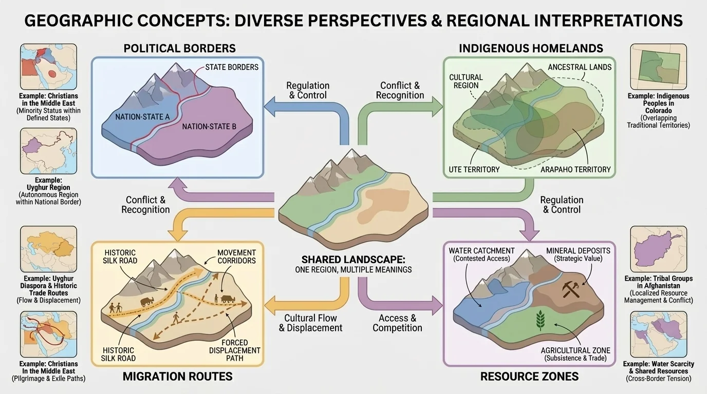
Spatial perspective means understanding that location matters, but so does point of view. One landscape can carry several meanings at once, as [Figure 1] illustrates through overlapping borders, routes, and homelands. A state may emphasize official boundaries, while an indigenous community may emphasize long-standing relationships to rivers, mountains, migration paths, and sacred sites.
Geographers also use the idea of scale. At a local scale, a neighborhood, valley, or village may be the most important unit of life. At a regional scale, mountain systems, trade corridors, or language zones may matter more. At a national scale, governments often organize land through provinces, borders, and census categories. Understanding scale prevents us from assuming that one map or one political unit tells the whole story.
Another key idea is cultural landscape, the visible imprint of human life on the land. Roads, mosques, churches, grazing routes, place names, irrigation systems, monuments, and even ruins all reveal how people shape places over time. Cultural landscapes are not neutral. They reflect who had power to build, rename, settle, preserve, or erase.
Indigenous populations are peoples with deep historical ties to a land before conquest or state expansion and who maintain cultural traditions linked to that place. Dominant populations are groups that hold greater political, economic, or cultural power within a state or region. Marginalized populations are groups pushed to the edges of power, often facing discrimination, restricted rights, or unequal access to land, representation, and resources.
These categories can overlap. A group may be dominant in one place but marginalized in another. A religious minority may be culturally rooted in a region for thousands of years yet still be treated as foreign. A state may be politically dominant but still feel vulnerable at its borders. Geography becomes richer when we recognize these layered realities instead of reducing places to single labels.
Territory is not just land on a map. It is land controlled, claimed, defended, regulated, and imagined. States build roads, checkpoints, schools, dams, and military bases to strengthen their control. Communities build shrines, maintain oral histories, preserve burial sites, and continue traditional land use to affirm their belonging.
Human-environment interaction also varies by perspective. A desert may be described by officials as empty or underused, while local pastoralists know it as a seasonal route with precise water knowledge. A mountain range may appear to isolate communities, yet it can also protect local autonomy and preserve languages and traditions. As seen earlier in [Figure 1], geographic features gain meaning through the people who live with them.
Power affects movement as well. Some people cross borders with passports, investment capital, or military protection. Others move because of war, poverty, climate stress, or expulsion. Migration, forced removal, refugee flows, and settlement policy are all geographic processes tied to who has authority and who does not.
Why multiple perspectives matter in geography
If we rely only on official maps and government categories, we may miss older place names, seasonal movement patterns, minority neighborhoods, sacred lands, and displaced communities. Multiple perspectives do not mean every claim is equally powerful in law, but they do mean every claim has geographic meaning worth investigating.
This approach is especially important in places where conflict, colonization, state-building, or cultural repression have reshaped the landscape. The following case studies show how the same region can be understood very differently depending on who is speaking.
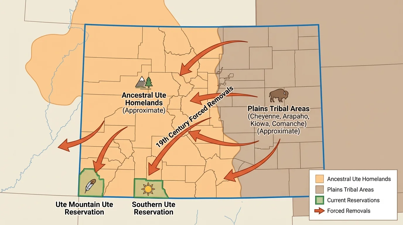
Colorado is often presented as a state of mountains, ski resorts, cities, and public lands. But Colorado's political map hides older Indigenous geographies, as [Figure 2] makes clear through homelands and movement routes that long predate the state. Ute peoples have especially deep ties to western Colorado, while Arapaho and Cheyenne peoples are connected to the plains and eastern areas. Other Indigenous nations, including Diné/Navajo, Apache, and Pueblo peoples, also have historical relationships to lands that now fall within or near Colorado's borders.
Before U.S. expansion, these lands were not empty wilderness. They were part of active networks of trade, hunting, diplomacy, seasonal migration, and spiritual practice. Mountains, river basins, and plains ecotones shaped movement and settlement. The Front Range, the San Luis Valley, the Colorado Plateau edge, and the eastern grasslands all held different meanings for different communities.
During the nineteenth century, military conquest, settler expansion, mining booms, and federal policy transformed the region. Treaties were repeatedly broken. Indigenous communities were removed from valuable land, especially where gold, silver, rail routes, and farming potential attracted settlers. The Sand Creek Massacre in 1864 remains a major historical example of how violence and geography intersected in Colorado.
Today, the geography of Colorado still reflects these histories. Reservation lands, protected cultural sites, place names, tourism landscapes, water disputes, and public memorials all reveal ongoing struggles over recognition and belonging. A dominant narrative may celebrate settlement and recreation, while indigenous perspectives emphasize dispossession, survival, stewardship, and unceded connections to land.
One important geographic issue is land management. Federal and state agencies often govern forests, parks, and water systems. Yet Indigenous communities may understand these same areas as ancestral territories containing sacred peaks, plant-gathering areas, and burial places. When wildfire management, mining, pipelines, or tourism development are debated, geography is not only about physical land use. It is also about whose history and authority are recognized.
Case example: Colorado place names and memory
Step 1: A map labels a mountain, town, or valley with an English or Spanish-derived name.
Step 2: Indigenous communities may have an older name for that same place, tied to an event, a spiritual meaning, or a seasonal use.
Step 3: When only the state-approved name appears in public life, the landscape seems to begin with settlement rather than with deeper Indigenous history.
This is a geographic example of how naming can shape public memory and power.
Seen in this way, Colorado is not just a state within the United States. It is also a layered Indigenous homeland whose geography cannot be fully understood through state borders alone. The overlapping patterns shown in [Figure 2] remind us that present-day boundaries often sit on top of older spatial systems.
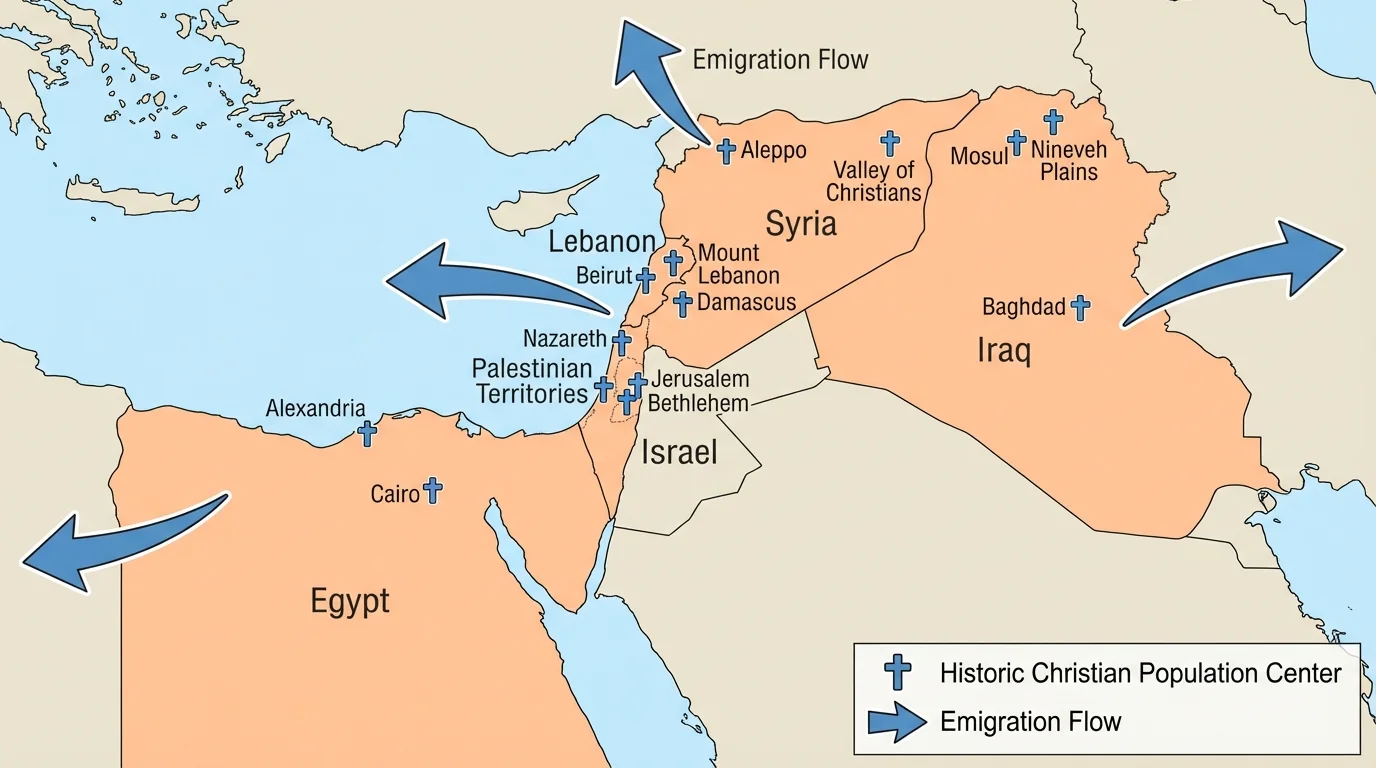
Many people are surprised to learn that Christianity began in the Middle East and that Christian communities there are indigenous to the region. The distribution of these communities across Egypt, Lebanon, Syria, Iraq, and Palestine/Israel appears in [Figure 3], which highlights both long-established population centers and later migration pressures. Treating Christians in the Middle East as outsiders ignores deep historical roots that go back to the earliest centuries of the religion.
These communities are diverse. They include Coptic Christians in Egypt, Maronite Christians in Lebanon, Assyrian and Chaldean Christians in Iraq, Armenian communities in several states, and Arab Christian communities in places such as Palestine, Jordan, Lebanon, and Syria. They speak different languages, follow different church traditions, and live in both cities and rural areas.
Geography matters because these communities are unevenly distributed. Some are concentrated in historic urban centers, river valleys, mountain districts, or older trade regions. Lebanon's mountains, for example, historically offered refuge and local autonomy to some Christian groups. In Egypt, large Coptic populations are rooted in the Nile Valley and major cities. In Iraq and Syria, war and instability have sharply changed settlement patterns.
Conflict has been one of the strongest recent geographic forces affecting Christians in the Middle East. The Iraq War, the Syrian civil war, the rise of the Islamic State, political instability, and economic hardship have all driven migration. Some Christian neighborhoods have lost population through emigration to Europe, North America, and Australia. This changes not only demographics but also cultural landscapes such as churches, schools, cemeteries, and historic districts.
At the same time, Christians in the Middle East should not be understood only through persecution narratives. They have long played major roles in education, publishing, medicine, trade, politics, and the arts. In some places they are integrated into national life; in others they face discrimination or insecurity. Geography helps explain these differences because legal systems, urban concentration, border changes, war zones, and economic opportunity vary from state to state.
Some of the world's oldest continuously used churches, monasteries, and Christian pilgrimage sites are in the Middle East, showing that the region is not only important to the history of Christianity but central to its living geography today.
A dominant national narrative may emphasize unity and citizenship. A minority community may focus more on security, representation, and preserving heritage. Diaspora communities abroad may see the homeland through memory and loss. These layered perspectives are geographic because they involve place attachment, movement, and the changing map of where people can safely live. The migration routes connected to [Figure 3] reveal how conflict in one place can reshape communities across the world.
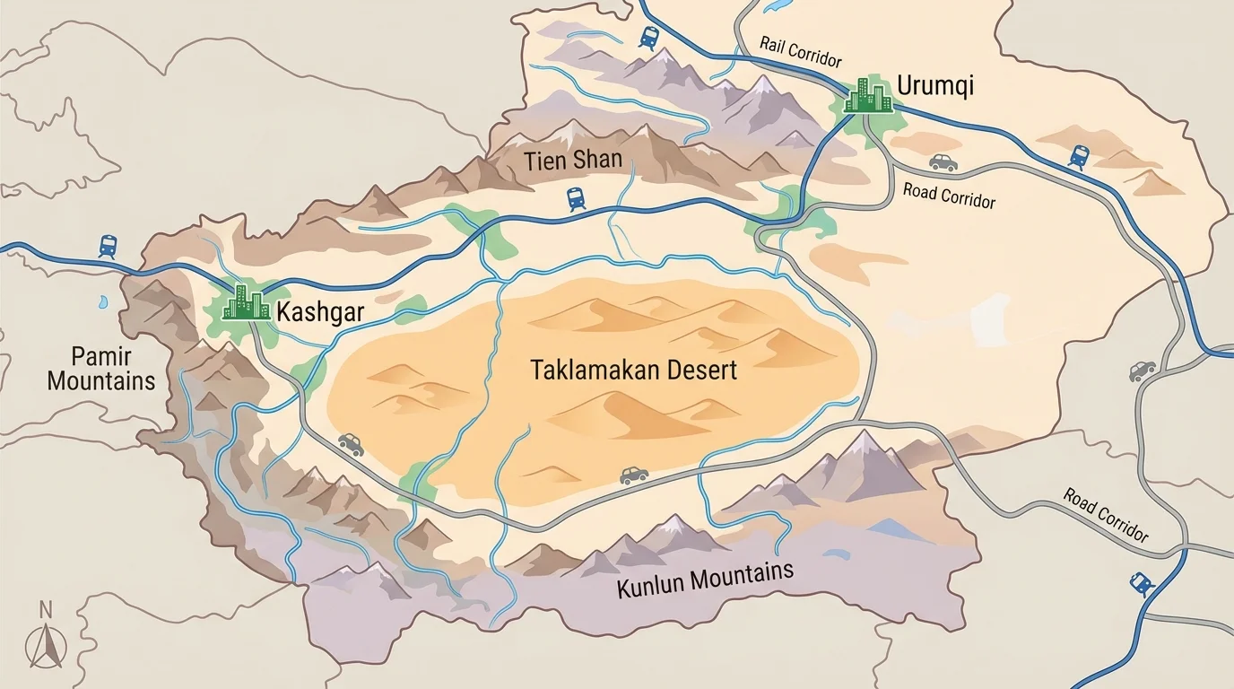
The Uyghurs are a mostly Muslim, Turkic-speaking people whose homeland lies in the region that the Chinese state calls Xinjiang. This region functions both as a homeland and as a strategic frontier, as [Figure 4] shows through its deserts, mountain rims, oasis cities, and transport corridors. Geography is central to understanding why this area matters so much politically.
Xinjiang is located in northwestern China and borders several Central Asian states. Much of the region is dry, with the Taklamakan Desert surrounded by mountain systems. Human settlement has historically clustered around oasis cities such as Kashgar, Hotan, and Turpan, where water and trade made urban life possible. Because of its position along historic Silk Road routes, the region has long connected China, Central Asia, and beyond.
From the perspective of the Chinese state, Xinjiang is important for border security, energy resources, infrastructure, and national integration. The region contains oil, gas, cotton production, and major transportation links connected to trade and development projects. From many Uyghur perspectives, however, the same policies can be experienced as cultural assimilation, demographic pressure, religious restriction, and political repression.
Population patterns have changed over time as migration and state policy encouraged greater settlement by Han Chinese populations in some urban and industrial areas. This has affected labor markets, language use, education, and political representation. In geography, this is a reminder that demographic change is not just a number. It alters who feels at home, who controls institutions, and whose culture is visible in public space.
International reports and human rights investigations have drawn attention to mass detention, surveillance, family separation, labor coercion, and restrictions on religion and language affecting many Uyghurs. These policies are geographic as well as political. They shape mobility, reshape neighborhoods, regulate sacred spaces, and transform everyday life across the region.
"Maps do not simply describe power; they can also help organize it."
— Geographic principle often applied in political geography
Official narratives often frame these actions as anti-extremism, modernization, or development. Uyghur and human rights perspectives often frame them as forms of repression and cultural erasure. A careful geographic analysis does not ignore either set of claims, but it pays close attention to evidence, scale, and lived experience. The physical setting in [Figure 4] helps explain why oasis settlement, transport corridors, and border control are all so politically charged.
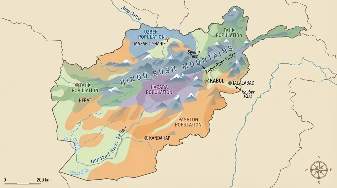
Afghanistan's geography makes local control especially important. Mountain barriers, valleys, and difficult travel routes shape settlement and power, as [Figure 5] displays through major ranges and broad ethnic regions. In a place where movement can be slowed by terrain, local networks often matter more than distant state authority.
Afghanistan includes a wide mix of ethnic and tribal communities, including Pashtuns, Tajiks, Hazaras, Uzbeks, and others. Not all of these categories are the same as tribes, and the country's social structure is more complex than simple labels suggest. Still, tribal affiliation, kinship networks, village ties, and regional identities have historically played major roles in organizing social and political life, especially among many Pashtun communities.
The Hindu Kush mountain system divides and channels movement. Valleys can support farming and local settlement, while highlands and steppe zones support seasonal herding in some areas. Passes and roads become strategically important because they connect otherwise separated regions. This means geography strongly influences trade, military campaigns, migration, and governance.
Tribal and ethnic geography in Afghanistan has also been shaped by war, displacement, and foreign intervention. Soviet invasion, civil war, Taliban rule, U.S.-led intervention, and more recent political changes have all influenced who controls territory and who flees from it. Refugee flows into Pakistan and Iran, and later returns, have repeatedly changed local demographics.
From a central government perspective, fragmented geography can seem like a challenge to national unity and administrative control. From many local perspectives, however, local autonomy may appear necessary for survival, representation, and cultural continuity. Outside powers often underestimate how much mountains, roads, weather, and local alliances matter on the ground.
Remember that a region's physical geography does not determine human behavior, but it does shape opportunities and constraints. Mountains do not automatically cause conflict, yet they can make centralized control harder and preserve local identities over long periods.
Afghanistan also shows why geographers must be careful with broad terms like "tribal." Such terms can become stereotypes if used loosely. Good geographic analysis asks where people live, how they move, how they organize authority, and how conflict or displacement changes those patterns over time. The terrain and settlement patterns in [Figure 5] help explain why national maps can miss local complexity.
These four examples come from very different world regions, but they share several geographic patterns. First, identity is spatial. People connect who they are to mountains, valleys, rivers, cities, routes, shrines, grazing land, and neighborhoods. Second, states and communities often map land differently. Official boundaries may not match ancestral territories, sacred geographies, or minority settlement patterns.
Third, movement matters. Forced removal in Colorado, emigration from the Middle East, regulated movement in Xinjiang, and refugee flows in and out of Afghanistan all show that geography includes mobility as much as location. A place is shaped not only by who lives there now, but also by who was pushed out, who returned, and who is prevented from moving freely.
Fourth, environmental settings influence political possibilities. Mountains in Colorado and Afghanistan can preserve local identities but also become sites of contest. Desert-oasis systems in Xinjiang shape settlement and transport. River valleys and mountain refuges in the Middle East help explain why some minority communities endured in certain places for centuries.
| Case | Dominant Perspective Often Emphasizes | Indigenous or Marginalized Perspective Often Emphasizes | Key Geographic Themes |
|---|---|---|---|
| Indigenous Peoples in Colorado | State borders, settlement, recreation, resource use | Ancestral homelands, treaty violations, sacred sites, survival | Removal, land management, place names, memory |
| Christians in the Middle East | National unity, regional conflict, demographic change | Historical rootedness, security, heritage preservation | Urban centers, migration, minority landscapes |
| Uyghurs in China | Security, development, integration, border control | Homeland, religious freedom, language, repression | Frontier region, oasis settlement, surveillance, migration |
| Tribal Groups in Afghanistan | State authority, territorial control, national governance | Local autonomy, kinship, survival, regional identity | Mountains, valleys, mobility, fragmented power |
Table 1. Comparison of dominant and marginalized geographic perspectives across the four case studies.
Across all of them, one of the most important geographic questions is this: who gets to define the meaning of a place? The answer is rarely simple, and it often changes over time.
Maps feel objective, but every map makes choices. It chooses what to include, what to leave out, what language to use, and which boundaries to emphasize. A school atlas, a military map, an indigenous land map, a refugee route map, and a religious heritage map can all represent the same region differently.
That is why geographers compare multiple kinds of evidence: government statistics, satellite imagery, oral histories, religious records, archaeological evidence, interviews, census data, and local knowledge. Some sources are more precise for certain questions, but no single source captures everything.
Questions to ask when examining geographic perspectives
Who made this map or source? What scale is it using? Which groups are visible, and which are missing? Does it show movement, memory, or only current political boundaries? Does it treat a place as empty when people know it as inhabited, sacred, or historically important?
For students, this way of thinking is useful far beyond these case studies. It applies to debates over pipelines, urban neighborhoods, migration borders, religious sites, indigenous land acknowledgments, conservation areas, and climate adaptation. Geography is not only the study of where things are. It is the study of how places connect to power, identity, and lived experience.