A town can be safe in one place and unsafe just a few miles away. Why? The answer is often geography. Geography is the study of places and how people and the environment affect each other. A river can give people water, but it can also flood. A mountain can protect a town, but it can also make travel hard. A coast can be great for fishing, but storms can damage homes. People have always had to study the places where they live and find smart ways to solve problems.
Every place on Earth has its own mix of landforms, water, weather, plants, and natural resources. Some places are flat and rainy. Some are dry and hot. Some are close to oceans, while others are surrounded by mountains. These differences matter because they shape what people can build, how they travel, which crops they can grow, and how safe they are during natural events.
When people understand geography, they can make better choices. They can decide where to build homes, roads, bridges, farms, and schools. They can also prepare for dangers. A family living near a river may need to know the safest route to high ground. A farmer in a dry area may need to plan how to save water. Geography helps people think about where things happen and why that place matters.
Geography-based problem is a problem that happens because of a place's land, water, climate, distance, or natural features.
Landform is a natural feature of Earth's surface, such as a mountain, hill, valley, plain, or plateau.
Climate is the usual pattern of weather in a place over a long time.
Geography-based problems are not the same everywhere. A snowy mountain village and a hot desert town do not face the same challenges. That is why people use geographic tools to study places carefully before making plans.
A geography-based problem can happen when nature and human needs do not match easily. For example, people need water to drink and grow food, but some places do not get much rain. People need safe places to live, but some land is at risk of flooding or landslides. People need to travel, but mountains, wide rivers, or long distances can slow them down.
To understand these problems, people use tools such as maps, globes, photographs, and satellite images. A map scale helps show distance. A legend explains symbols on a map. A satellite image gives a view of Earth from space. These tools help people compare locations, notice patterns, and decide what kinds of solutions fit each place.
Remember that a map is a model of a place. It does not show everything, but it helps us understand location, direction, and distance. A compass rose shows direction, and a scale helps us estimate how far places are from each other.
[Figure 1] Geographic tools are especially useful because many problems are about space. Where is the river? Which land is highest? How far is the nearest town? Which side of the mountain gets more rain? These are all geography questions, and the answers help people solve real-world problems.
One common geography-based problem is flooding. Floods often happen near rivers, lakes, or coasts. They can also happen in cities where rainwater has nowhere to go. The way water moves across the land matters because homes, rivers, and flood barriers are all connected to location. Low land near a river is more likely to flood than high land farther away.
Rivers overflow when there is heavy rain, melting snow, or a strong storm. Water spreads over a floodplain, which is the flat land beside a river. Floodplains are good for farming because the soil is rich, but they can be dangerous places for houses and roads if the river rises too high.
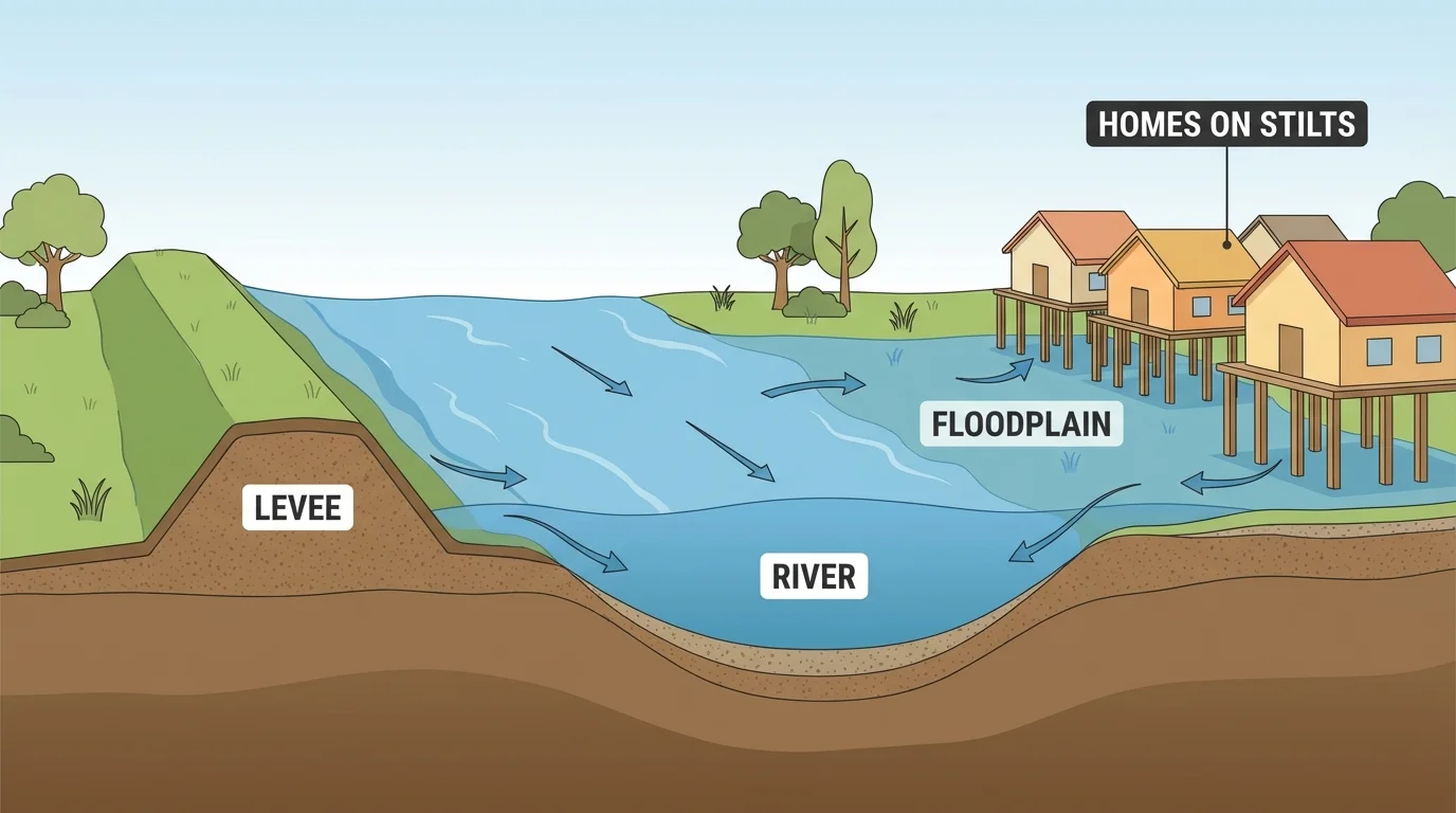
People have tried many ways to solve flood problems. Some towns build levees, which are raised walls of earth or concrete that help keep water in the river. Some communities dig drainage channels so rainwater can move away faster. In places that flood often, people may build houses on stilts so the living space stays above the water. Cities also use warning systems to tell people when to move to safer places.
Case study: A river town
A small town sits next to a river that floods every spring.
Step 1: People study a map of the town and mark the lowest land near the river.
Step 2: They notice that homes on the low floodplain are at greatest risk.
Step 3: The town builds a levee near the river and raises some homes on stilts.
Step 4: The town also creates an evacuation route to higher ground.
This solution works well because it fits the geography of the place.
Flood solutions can help a lot, but they are not perfect. A levee may protect one area while pushing water toward another area. That is why people must study the whole region, not just one small spot. Later, when people compare solutions in different countries, [Figure 1] still helps explain why the shape of the land is so important.
In some places, the main problem is not too much water but too little. Dry regions may have little rain for a long time. This is called drought. Drought can make it hard to grow crops, raise animals, and find enough drinking water.
People solve water shortages in different ways. They may dig wells to reach groundwater. They may build canals to bring water from rivers to farms. They may create reservoirs, which are places where water is stored for later use. In some homes, people collect rainwater from rooftops in large containers. Farmers may also use careful watering methods so less water is wasted.
The best solution depends on the place. In a desert, people may need to save every drop. In a place with rainy seasons and dry seasons, people may store water during the wet months and use it later. Geography helps people decide when, where, and how to store water.
Some of the world's driest places still have people living in them because people learned how to store and move water very carefully. Water systems can make a difficult place livable and help a community succeed.
Water problems can also lead to movement. If farms cannot grow enough food, families may move to wetter places. This shows that geography can affect not only buildings and roads, but also where people choose to live.
[Figure 2] Landforms can make travel difficult. Steep mountains, deep valleys, thick forests, and wide rivers can separate places that are actually close on a map. The shape of the land changes travel routes, and towns may need roads, tunnels, and bridges to stay connected. Without these paths, people may have trouble going to school, getting supplies, or visiting doctors.
Mountains are a good example. A mountain range can block easy travel from one side to the other. Instead of moving in a straight line, people may have to go around the mountains or through a narrow pass. Roads in mountain regions often curve because builders must follow safer slopes.
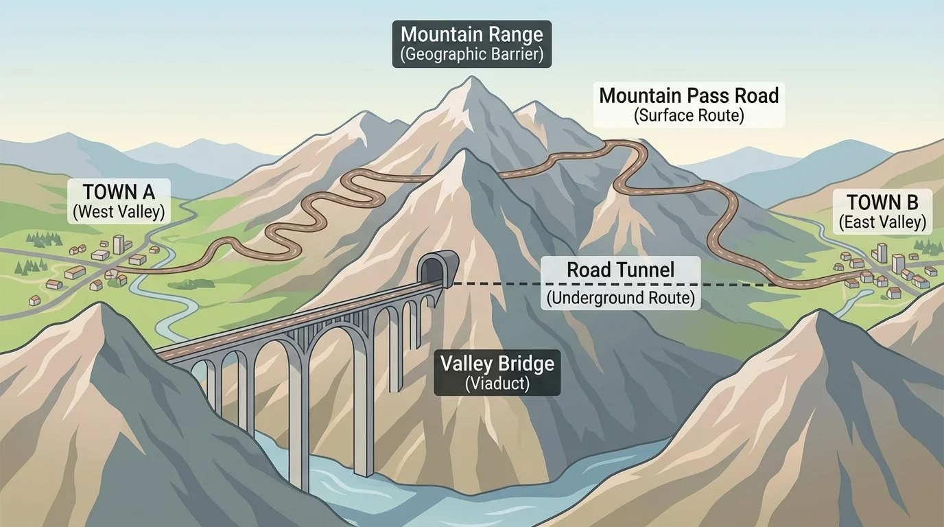
People solve travel problems by building roads, bridges, tunnels, rail lines, and ferries. A bridge can connect two sides of a river. A tunnel can go through a mountain. A ferry can carry people and cars across water. In very snowy places, workers may clear roads often so travel can continue during winter.
These solutions make trade and communication easier. Food, medicine, books, and building supplies can move more quickly. But building through mountains or across rivers can cost a lot and may affect the environment. A road can cut through wildlife habitats, so planners must think carefully before building.
Location changes how hard travel is
Two places may be close in distance but still hard to reach because of landforms. A flat plain usually allows straighter roads, while mountains and deep water force people to change direction, climb, or cross obstacles.
The same idea applies to islands and remote regions. People living on islands often depend on boats and airplanes. People in far northern areas may use roads in warm seasons and different routes in winter. As shown earlier in [Figure 2], solving travel problems is really about understanding space and landforms.
Some places have risks because the ground itself can change suddenly. Earthquakes, volcanoes, and landslides are examples. These dangers are linked to the location of mountains, slopes, and cracks in Earth's crust. People who live in such places must pay close attention to the land.
A landslide can happen when rocks and soil move downhill, especially after heavy rain. This makes steep slopes risky places for homes and roads. To solve the problem, people may build walls to hold the soil in place, plant grasses, shrubs, or trees whose roots help hold the ground together, or avoid building on the most dangerous slopes.
In earthquake-prone places, builders often use special designs so buildings can shake without falling easily. Communities may also practice emergency drills. Near volcanoes, scientists monitor the mountain to watch for signs of change, and towns make evacuation plans.
Case study: Building on a steep hillside
A road on a hillside is often blocked by landslides after storms.
Step 1: Workers notice that rain makes the soil loose.
Step 2: They study the slope and find the weakest places.
Step 3: They add support walls and plant grasses and shrubs with strong roots.
Step 4: They change the road design so water drains away instead of soaking the slope.
This solution uses knowledge of the land and water together.
Not every dangerous place should be used in the same way. Sometimes the best solution is not to build there at all. Geography helps people decide which places are safer and which places need extra care.
Coasts are important places for homes, ports, fishing, and trade. Many people live near oceans because these areas offer jobs and transportation. But coasts also have geography-based problems. Storms can bring strong winds and high water. Waves can wear away land in a process called erosion. Salt water can harm fresh water supplies and farmland.
People use several solutions along coasts. They may build seawalls to protect the shore. They may plant or protect mangroves and sand dunes because these natural barriers can slow waves and wind. Some communities move buildings farther inland instead of building too close to the shore.
Natural solutions can be very powerful. Wetlands, dunes, and coastal plants help absorb some storm energy. They also provide homes for animals. Sometimes protecting nature is also a way to protect people.
"The best place for a building is not always the easiest place to build it."
— Geographic planning idea
Coastal communities must also think about change over time. A safe beach today may not remain the same after many years of erosion. Good planning means looking at both the present and the future.
[Figure 3] When geographers, city planners, engineers, and community leaders study a place, they use several tools together. These tools work as a team. One map might show roads. Another might show rivers. A satellite image might show forests, farms, and neighborhoods. A map key or legend helps readers understand symbols and colors.
A compass rose shows direction: north, south, east, and west. A scale tells how map distance matches real distance. If two towns look close together, the scale helps us know whether they are really a short trip away or much farther. These details help people choose routes and safer locations.
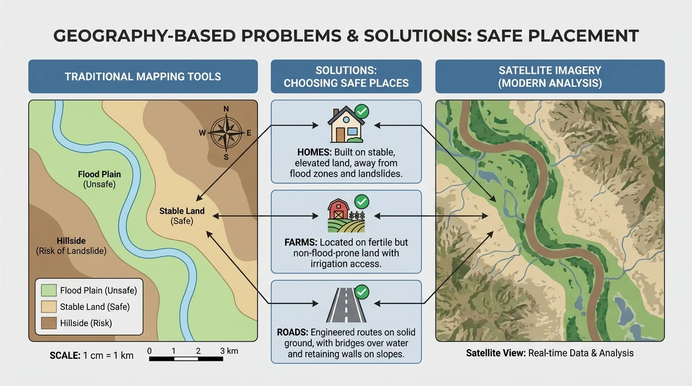
Geographic data can also show patterns. For example, if many floods happen in the same low area, people can see that pattern on a map. If wells are drying up in the driest part of a region, a map can help show where water is most needed. Looking for patterns is part of spatial thinking, which means thinking about where things are and how places connect.
| Tool | What It Helps People Learn | Example Use |
|---|---|---|
| Map | Location and direction | Finding a safe evacuation route |
| Globe | Earth's shape and location of continents and oceans | Comparing world regions |
| Satellite image | What the land looks like from above | Seeing forests, rivers, and cities |
| Legend | Meaning of map symbols | Understanding roads, water, or elevation colors |
| Map scale | Real distance | Estimating travel length |
Table 1. Geographic tools and how they help people study and solve place-based problems.
Later, when people compare solutions in different world regions, the same basic tools remain useful because they can help with floods, drought, travel, and coastal problems.
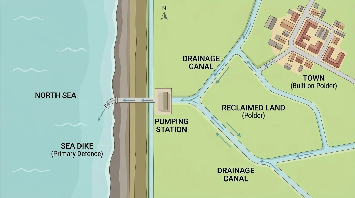
[Figure 4] In the Netherlands, much land lies very low, near or even below sea level. People there have built dikes and used pumps and canals to keep water out of important land. This lets people live and farm in places that might otherwise be underwater.
Along the Nile River in Egypt, people have long depended on river water in a dry region. Water systems help farms grow crops where rainfall is limited. This is an example of solving a dry-climate problem by using a nearby river wisely.
In mountain countries such as Nepal or Switzerland, roads often follow valleys and passes because steep slopes are harder to cross directly. In coastal places such as parts of Bangladesh, people may raise homes, build shelters, and prepare for floods and storms.
These case studies show that there is no single answer for every place. Geography is local. People must study each region's land, water, and weather. Even when different places face similar problems, the exact solution may differ because the geography is different. The Netherlands example in [Figure 4] is very different from a mountain road solution or a desert water system.
Solving one geography-based problem can sometimes create another challenge. A dam may store water, but it can change river habitats. A seawall may protect buildings, but it may also change the movement of sand along the coast. A new road may help travel, but it may cut through forests or animal homes.
Because of this, people must make careful choices. They ask questions such as: Who will be helped? What might be harmed? Is there a safer place to build? Can a natural solution work instead of a large structure? Good geography study helps people think ahead.
There is not always one perfect solution
People often compare several ideas before choosing one. The best choice usually depends on the exact place, the people who live there, the cost, and the effect on nature.
Geography-based problems remind us that people are always connected to the places where they live. Rivers, coasts, mountains, climate, and distance can create challenges, but people use knowledge, tools, and teamwork to respond. Studying location and land helps communities prepare, build wisely, and live more safely.