One of the fastest ways to understand United States history is to look at a map and ask a simple question: How did all of that land become part of one country? The answer is not simply that people moved west. The United States gained territory through purchases, treaties, war, annexation, and negotiation. Each method followed patterns, and those patterns help explain why certain events happened, why some regions became valuable, and why expansion often created conflict.
Land is never just empty space on a map. It includes rivers, coastlines, mountains, farmland, minerals, trading routes, and places where people already live. When historians study land acquisition, they are really studying power, movement, geography, and decision-making. A nation that controls a major river system can influence trade. A nation that gains a coastline can increase shipping and naval power. A nation that adds land suitable for farming may attract settlers and reshape its economy.
For the United States, land acquisition changed the country's size, economy, population, and politics. It also deeply affected Native American nations, Mexico, Spain, Russia, and other powers. Expansion was not a smooth or harmless process. It often involved pressure, conflict, broken promises, and the forced movement of people.
Land acquisition is the process by which a country gains control of territory.
Annexation is the formal addition of a territory to a country.
Cession is the giving up of land, usually by treaty.
Treaty is a formal agreement between governments.
Manifest Destiny is the nineteenth-century belief that the United States was meant to expand across North America.
When we study this topic, we are also using geography. A map helps us see where land was added, what physical features made it valuable, and how patterns developed over time. Historians focus on causes and consequences, while geographers focus on location, movement, and spatial patterns. Together, these approaches make the story clearer.
Spatial pattern becomes easier to recognize when students examine historical maps, as [Figure 1] shows through the westward growth of U.S. territory. By comparing maps from different years, we can see that many acquisitions pushed the country toward major waterways, the Gulf of Mexico, the Pacific Coast, and key trade routes.
A good historical map can reveal several things at once: borders, neighboring countries, rivers, mountain ranges, ports, and settlement routes. A timeline adds another layer by showing when acquisitions happened. If we combine time and place, we can ask stronger questions. Why did expansion happen rapidly in the 1840s? Why were the Mississippi River and New Orleans so important? Why did the United States want access to the Pacific Ocean?
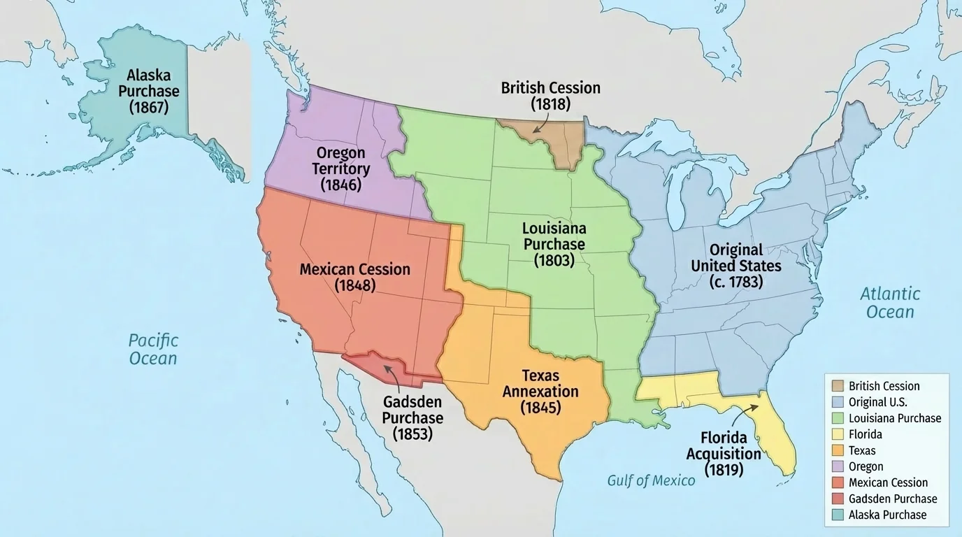
Other useful geographic tools include scale, region, and distribution. Scale helps us understand how large an acquisition was. Region helps us group places by shared features, such as the Mississippi Valley or the Pacific Coast. Distribution helps us notice where events are clustered. For example, many major acquisitions happened in the South and West, where access to rivers, ports, and fertile land mattered greatly.
Maps do more than display territory. They also help explain motives. A flat outline of borders may look simple, but once rivers and mountains are added, the logic of certain decisions becomes easier to see. Control of New Orleans mattered because goods from the interior traveled down the Mississippi River. Control of Pacific harbors mattered because the nation wanted trade connections across the ocean.
The United States did not gain all of its territory in one way. Instead, several repeating patterns appear across history. One pattern is purchase, in which the United States paid another country for land. Another is treaty negotiation, in which borders were settled through diplomacy. A third is annexation, often after settlers or political leaders pushed for union. A fourth is land gained through war and cession, when a defeated country gave up territory. Sometimes these methods overlapped.
Another pattern involves geography itself. The United States often sought land that improved transportation, expanded agriculture, added ports, or created defensible borders. River valleys, coastlines, and routes through the continent were especially important. Even smaller acquisitions could matter if they connected larger systems, such as a railway route or an outlet to a major body of water.
The Louisiana Purchase added about 828,000 square miles to the United States, roughly doubling the nation's size at the time. A single agreement changed the map of North America almost overnight.
There is also a political pattern. Many land acquisitions intensified arguments over slavery, representation in Congress, and the balance between free and slave states. So expansion was never only geographic. It was also constitutional, economic, and moral.
The first major territorial pattern appeared right after independence. In the Treaty of Paris of 1783, Britain recognized the United States and granted land east of the Mississippi River, stretching west from the original states to that river. This gave the new nation much more room to grow, but it also raised difficult questions about governing western lands and dealing with Native nations already living there.
The Mississippi River quickly became one of the most important geographic features in the country. Farmers in inland areas needed a way to move crops to market. Since river transport was faster and cheaper than overland travel, access to the Mississippi and the port of New Orleans became a national priority. This is one of the clearest examples of geography shaping policy. The United States wanted not just land, but land connected to movement and trade.
Geography shapes national goals
Countries often seek land that improves access, security, and resources. In the early United States, leaders understood that interior farms were less useful if goods could not reach major ports. Rivers acted like highways before railroads and interstate roads existed. Because of that, expansion toward the Mississippi Valley was both a geographic and an economic strategy.
The Northwest Ordinance also showed an early pattern in U.S. expansion: the federal government created a process to survey land, organize territories, and eventually admit new states. This meant that land acquisition was often followed by structured settlement and political integration.
The Louisiana Purchase of 1803 is one of the clearest examples of acquisition by purchase. As [Figure 2] shows, the United States bought the huge Louisiana Territory from France. This gave the country control of New Orleans and stronger access to the Mississippi River system, connecting inland farms to world trade through the Gulf of Mexico.
This acquisition followed a major geographic pattern: gaining land that improved transportation and economic opportunity. It also opened enormous areas for future settlement, exploration, and conflict. President Thomas Jefferson sent Meriwether Lewis and William Clark to explore the territory, gather information, and strengthen U.S. claims. Exploration itself became part of expansion, because the government needed maps, scientific observations, and knowledge of routes.
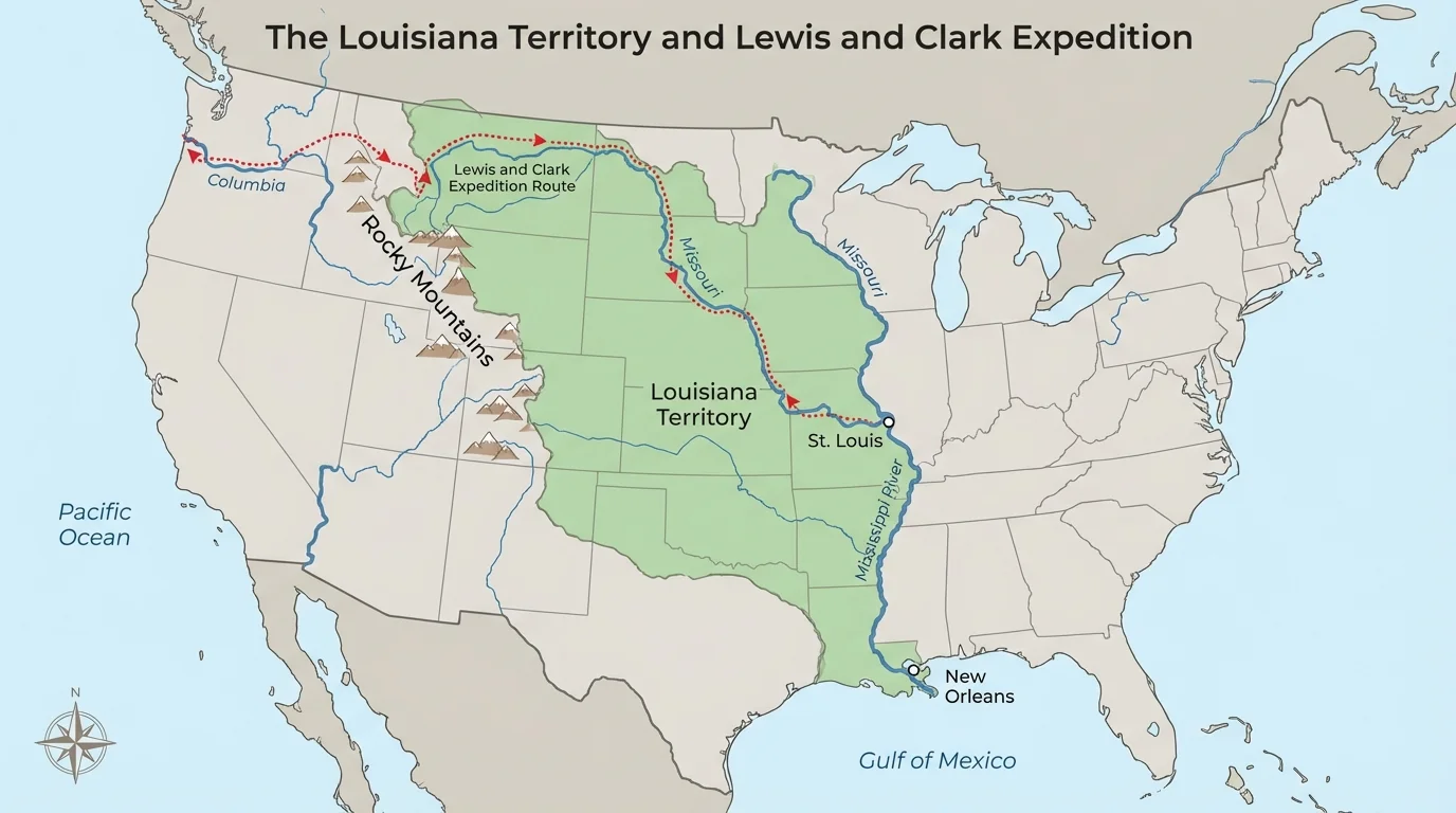
The purchase also showed that land acquisitions could happen quickly because of events outside the United States. France's leader, Napoleon Bonaparte, had changing priorities in Europe and the Caribbean. That larger international situation created an opportunity for U.S. expansion. History often works this way: local geography and global politics meet.
Later expansions repeated some of the same logic seen here. As with the river system shown in [Figure 2], leaders often wanted land that improved movement, linked regions together, and increased long-term economic power.
The next important pattern is acquisition by diplomacy. In 1819, the United States and Spain signed the Adams-Onís Treaty. Spain ceded Florida to the United States, and the treaty also helped define boundaries between U.S. and Spanish claims in North America. This reduced uncertainty on the southern border.
Florida mattered for several reasons. Its location gave access to the Southeast coast and helped secure the region against foreign influence. It was also connected to ongoing conflict involving Spain, the United States, and Native peoples, especially the Seminole. The treaty shows that diplomacy sometimes followed military pressure and border instability. Not every acquisition came from a simple peaceful agreement; often, negotiation happened because conflict made a settlement useful.
Geographically, Florida also helped the United States gain stronger control over the Gulf Coast. If we track the pattern from the Mississippi Valley to Florida, we can see a broader goal: securing the southern edge of the nation and controlling routes tied to trade and defense.
[Figure 3] The 1840s reveal one of the strongest patterns of all: rapid expansion through multiple methods at once across Texas, Oregon, and the Southwest. In this decade, the United States annexed Texas, negotiated with Britain over Oregon, and gained a huge cession from Mexico after war. Looking at these events together helps students see pattern instead of isolated facts.
Annexation appears clearly in Texas. After winning independence from Mexico in 1836, Texas existed as an independent republic for several years. In 1845, it became part of the United States. This mattered geographically because Texas was large, bordered Mexico, and extended U.S. influence farther southwest. Politically, annexation increased tensions with Mexico and raised arguments in the United States over slavery.
The Oregon Country shows a different method: diplomatic settlement. The United States and Britain had jointly occupied the region. In 1846, the Oregon Treaty set the boundary at the 49th parallel for most of the border. This gave the United States access to valuable Pacific Coast territory in the Northwest without going to war with Britain.
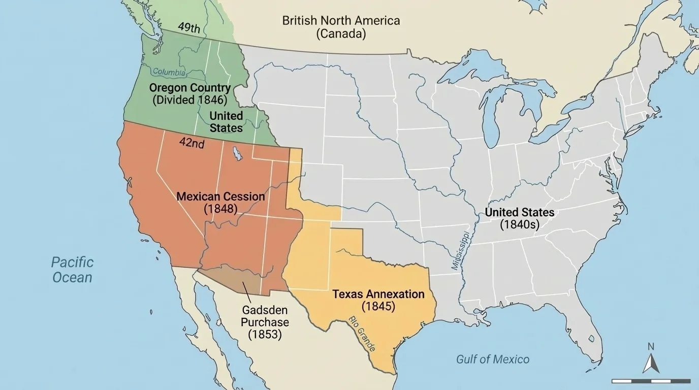
The Mexican-American War, fought from 1846 to 1848, led to the Mexican Cession. In the Treaty of Guadalupe Hidalgo, Mexico gave up a vast area that includes present-day California, Nevada, Utah, and parts of several other states. This is a clear case of land acquisition through war and treaty. The region included Pacific ports, mineral resources, and routes to the West Coast. Soon after, the California Gold Rush made the area even more important.
These three events are connected. As [Figure 3] makes visible, the United States expanded toward both the Pacific and the Southwest, using annexation, diplomacy, and war within only a few years. That pattern helps explain why the 1840s transformed the nation so dramatically.
Case study: Applying patterns to the Mexican Cession
How can we analyze this event using a geographic-historical pattern?
Step 1: Identify the method of acquisition.
The Mexican Cession came through war followed by a treaty.
Step 2: Identify the geographic value.
The land included Pacific coastline, interior basins, mountain passes, and access to California.
Step 3: Identify the consequences.
The acquisition increased westward settlement, intensified debates over slavery, and changed relations with Native peoples and Mexico.
This method can be applied to many other events from U.S. history.
The idea of Manifest Destiny helped justify these expansions for many Americans at the time, but historians also examine the costs. Expansion often meant displacement, military conflict, and broken agreements with Native nations.
In 1853, the United States made the Gadsden Purchase, buying a smaller strip of land from Mexico in what is now southern Arizona and New Mexico. Compared with the Louisiana Purchase or Mexican Cession, this area was much smaller. But size is not the only measure of importance.
The purchase fit another geographic pattern: acquiring land to improve transportation. U.S. leaders wanted a practical southern route for a transcontinental railroad. This shows how changing technology can shape land policy. Once railroads became more important, routes across deserts and valleys gained strategic value. Geography still mattered, but now in relation to engines, tracks, and national connection.
By this point, the outline of the contiguous United States was nearly complete. Yet the process remained tied to the same recurring questions: Which lands connect markets? Which regions strengthen borders? Which routes support future growth?
The pattern of purchase did not end in the Southwest. In 1867, the United States bought Alaska from Russia. At the time, some critics mocked the deal, but Alaska later proved valuable because of its location and natural resources. This reminds us that the importance of a territory is not always obvious right away.
Although much of this lesson focuses on the mainland, U.S. expansion also reached beyond it. In later years, the nation acquired islands and overseas territories for strategic, military, and economic reasons. The same geographic questions still apply: Where is the territory located? What routes does it control? What resources does it offer? How does it change the country's relationship to the wider world?
Remember that geographic analysis always asks both where and why there. A territory's distance from ports, rivers, mountain passes, and trade networks can help explain why leaders wanted it.
Alaska also shows that land acquisition did not always fit the older image of farmers moving west. Sometimes strategic position, naval access, fishing grounds, minerals, or future trade mattered more than immediate settlement.
[Figure 4] When we line these events up over time, a repeating sequence becomes clear: the United States gained land through treaties after war, direct purchase, negotiated borders, and annexation. Even though each case was different, the goals often overlapped. Leaders wanted control of waterways, fertile land, coastlines, transportation routes, and defensible boundaries.
These patterns also had major human consequences. Native American nations lost land, sovereignty, and access to resources. Some groups were forced westward or removed from ancestral homelands. Expansion also affected enslaved people, settlers, soldiers, and neighboring countries. The question of whether new territories would allow slavery became one of the most explosive political issues in the nineteenth century.
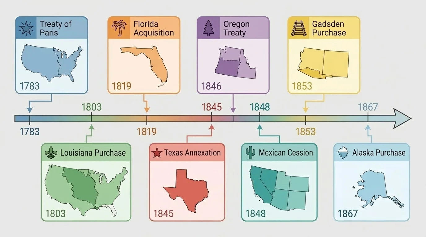
A pattern does not mean that every event was identical. Florida was not the same as Alaska, and Texas was not the same as Oregon. But by comparing them, students can spot common motives and methods. That is one of the most important skills in history: using specific facts to identify a broader pattern.
The timeline in [Figure 4] also makes another point clear: the pace of expansion was uneven. Some decades saw dramatic growth, while others focused more on organizing and governing land already gained. Expansion happened in bursts, often shaped by international politics, domestic debates, and new transportation needs.
To apply patterns of land acquisition to events of the past, ask four questions. First, how was the land acquired: purchase, treaty, annexation, or war? Second, what geographic features made the land valuable? Third, who benefited and who was harmed? Fourth, what political or economic consequences followed?
For example, if you study Texas, you can identify annexation, border conflict, cotton agriculture, and the slavery debate. If you study the Louisiana Purchase, you can identify purchase, river access, western exploration, and settlement. If you study the Oregon Treaty, you can identify diplomacy, Pacific access, and peaceful compromise with Britain. The same framework works again and again.
Pattern recognition in history
Recognizing a pattern means noticing repeated relationships across different events. In U.S. expansion, one repeated relationship is this: important geographic features often shaped the method and purpose of acquisition. When students see that connection, they move beyond memorizing isolated dates and begin to explain history.
This kind of thinking is useful far beyond one unit of study. Historians, geographers, and political leaders all look for patterns because patterns help explain why choices happen and what effects those choices may produce.
To study land acquisition well, students should use both primary sources and secondary sources. A primary source comes from the time being studied, such as a treaty, a map made in that period, a speech, a diary, or a government document. A secondary source is created later by historians who interpret the evidence.
Primary sources can reveal what leaders claimed they wanted, how borders were described, and how people at the time understood expansion. Maps are especially powerful because they combine history and geography. A map can show a claimed border, a disputed region, a river route, or the distance between settlements. Secondary sources help explain causes, compare events, and point out perspectives that people at the time may have ignored.
| Event | Main Method | Geographic Importance | Major Consequence |
|---|---|---|---|
| Treaty of Paris, 1783 | Treaty | Land to the Mississippi River | Expanded the new nation westward |
| Louisiana Purchase, 1803 | Purchase | Mississippi system and New Orleans | Doubled U.S. size |
| Florida, 1819 | Cession by treaty | Gulf Coast and southern security | Strengthened control in the Southeast |
| Texas, 1845 | Annexation | Southwestern expansion | Increased tension with Mexico |
| Oregon Treaty, 1846 | Diplomatic treaty | Pacific Northwest coast | Settled border with Britain |
| Mexican Cession, 1848 | War and treaty | Pacific ports and western interior | Raised major slavery debates |
| Gadsden Purchase, 1853 | Purchase | Southern railroad route | Completed key southwestern border area |
| Alaska, 1867 | Purchase | Resources and strategic location | Extended U.S. reach northward |
Table 1. Major U.S. land acquisitions, their methods, geographic importance, and consequences.
When you combine maps, timelines, treaties, and historical interpretation, the big picture becomes much clearer. The United States expanded in recognizable ways, and those ways were closely tied to geography. Rivers, coasts, resources, and transportation routes helped shape the nation's choices.
"Geography has made us neighbors. History has made us friends."
— John F. Kennedy
In U.S. history, geography also made some neighbors into rivals, trading partners, or targets of expansion. That is why studying land acquisition requires both careful evidence and ethical reflection.