Why did some early communities grow into major port cities while others spread out across large plantations or pushed into isolated valleys? The answer is not just about leaders, laws, or luck. It is also about place. Rivers, mountains, soil, climate, forests, and coastlines shaped the choices people made. In early U.S. history, where people settled affected how they worked, traded, fought, and governed. To understand important events, we have to understand geography.
Human settlement is the pattern of where people live and build communities. The environment includes natural features such as landforms, climate, water, plants, animals, and resources. Settlement and the environment are closely connected. People do not settle randomly. They look for fresh water, fertile land, safe harbors, building materials, transportation routes, and protection from dangers.
In early North America, European colonists, Indigenous nations, and later U.S. settlers all responded to the environment in different ways. Some groups adapted to local conditions over long periods of time. Others tried to reshape the land through farming, roads, ports, and towns. The relationship went both ways: the environment influenced settlement, and settlement changed the environment.
Settlement pattern is the way people and communities are distributed across an area. Region is an area with shared features, such as climate, landforms, economy, or culture. Natural resource is a material from nature that people use, such as timber, fertile soil, or fish.
When historians compare regions, they can see that different environments encouraged different ways of life. This helps explain why regional connections mattered so much in early U.S. history. New England developed differently from the Chesapeake, and both differed from the Appalachian backcountry or the Mississippi Valley.
To study these patterns, geographers and historians use tools such as physical maps, political maps, climate maps, and population maps. A good map reveals relationships quickly and helps show how the Atlantic coast, mountain barriers, and major rivers shaped early settlement. Instead of memorizing names only, students should ask geographic questions: Where is fresh water? Where are the mountains? Which rivers are navigable? Which places connect inland areas to the sea?
[Figure 1] Physical features often guide movement. Coastal plains make travel easier than steep mountains. Rivers act like highways, especially before railroads and highways existed. Harbors allow ships to anchor and trade. Mountain ranges can block travel, but gaps and valleys create pathways. Climate and growing seasons also matter because they affect what crops can be raised.
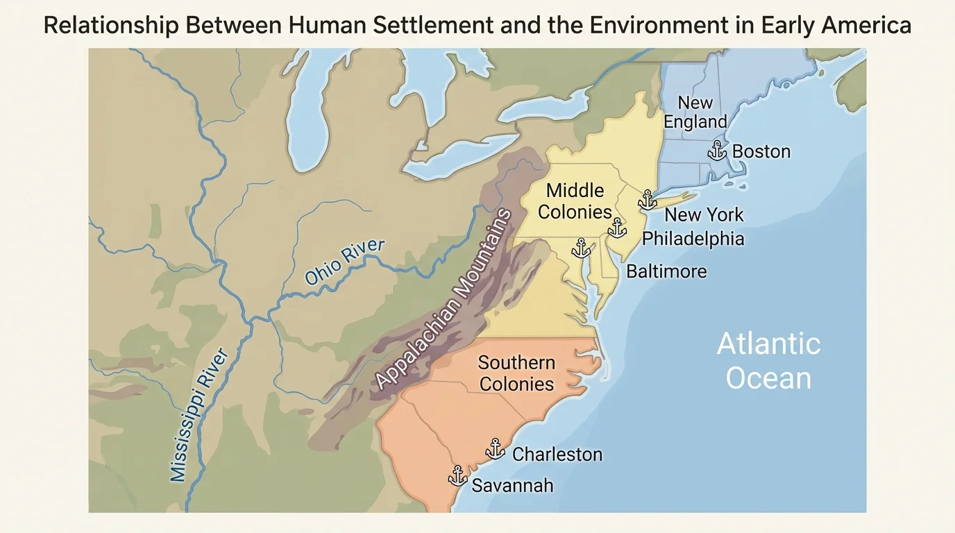
Geographic tools also help compare human-environment interaction across regions. For example, a map of rainfall and soil helps explain why plantation agriculture expanded in the South, while a map of rocky terrain and short growing seasons helps explain why New England relied more on trade, fishing, and shipbuilding.
Another useful tool is the idea of region. Regions are not just places on a map. They are areas where physical and human features connect. In early U.S. history, major regions included New England, the Middle Colonies, the Southern Colonies, the western frontier, and the Mississippi Valley. Each had a distinctive environment, and each contributed differently to major historical events.
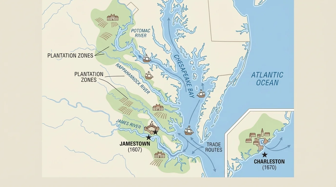
[Figure 2] The Southern Colonies, especially the Chesapeake and Tidewater areas, developed around wide coastal plains and long, slow rivers. These rivers reached deep inland and made it easier to move goods by boat. That meant people did not have to live in tightly packed towns near one central harbor. Instead, plantations spread along riverbanks.
The environment supported crops such as tobacco, rice, and later cotton in the South. Fertile soil, warm climate, and long growing seasons encouraged large-scale agriculture. This affected settlement patterns: farms and plantations were often far apart, and port activity depended heavily on river transport. In places like Virginia and South Carolina, settlement grew outward along waterways rather than clustering in many small towns.
This environmental pattern also connected to one of the most important and tragic developments in early American history: the growth of slavery. Plantation agriculture required a large labor force, and colonists increasingly relied on enslaved Africans. Geography did not cause slavery by itself, but the environment made plantation farming profitable, and that economic system helped slavery expand.
Ports such as Charleston became major centers of trade because they linked coastal and Atlantic commerce. Later, these southern settlement patterns influenced politics, economy, and conflicts between regions. Even during the American Revolution, coastal access and plantation wealth shaped southern strategy and alliances.
New England offered very different conditions. The soil was often rocky, the growing season was shorter, and the coastline had excellent natural harbors. Forests provided timber, and nearby ocean waters were rich in fish. Because large plantation agriculture was less practical in much of this region, many communities developed as towns rather than scattered plantations.
These environmental conditions encouraged a mixed economy. People farmed on a smaller scale, but they also fished, built ships, traded, and worked in crafts. Cities such as Boston grew because harbors connected the region to Atlantic trade. In other words, geography encouraged New England to become more maritime, commercial, and town-centered.
Some of the same forests that helped New England shipbuilders also made the region important to the British Empire. Tall, straight trees were valuable for ship masts, so natural resources in North America had military as well as economic importance.
Settlement patterns in New England also influenced community life. Town meetings, schools, churches, and local government became especially important where people lived closer together. Geography does not fully determine culture, but it strongly shapes daily life. Comparing New England to the South shows that environmental differences can lead to very different regional societies.
The Middle Colonies shared some features with both North and South. They had fertile soil, better farming land than much of New England, and major rivers such as the Hudson and Delaware. Cities like New York and Philadelphia grew where river systems and ports supported trade. This region became an important center of grain farming, transportation, and cultural diversity.
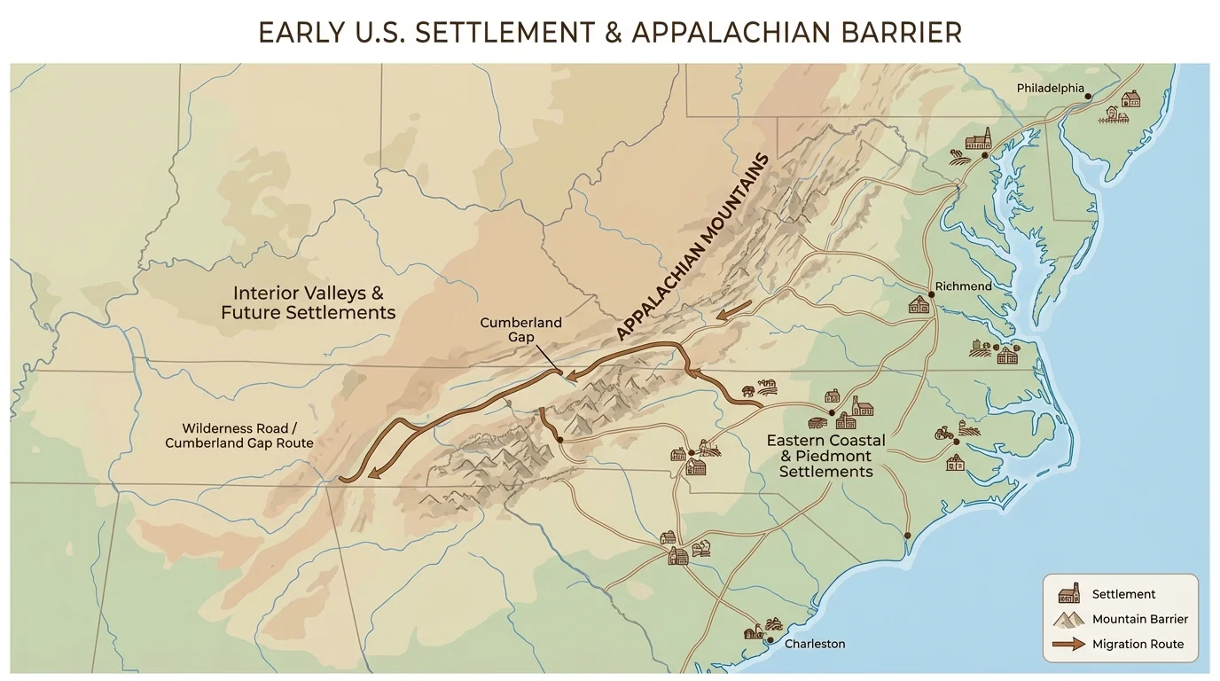
[Figure 3] The Appalachian Mountains formed one of the most important physical barriers in early U.S. history. The mountains blocked easy movement from the Atlantic coast into the interior, but valleys and gaps also guided migration. So the mountains functioned as both a barrier and a funnel.
[Figure 3] Settlers moving into the backcountry often followed river valleys or mountain passes. Places such as the Great Valley and Cumberland Gap became routes for westward movement. Because these areas were more isolated, settlements were often smaller and farther apart than coastal towns. Frontier life usually involved harder travel, weaker government control, and more direct conflict over land.
This region was already home to Indigenous nations, who understood the land deeply and had their own political systems, trade networks, and territorial boundaries. As settlers moved westward, competition over land increased. Geography shaped where conflict occurred, because valleys, river crossings, and mountain gaps became strategic points.
The British government tried to limit westward settlement after the French and Indian War with the Proclamation of 1763, which aimed to reduce conflict west of the Appalachians. Many colonists resented this. Here again, geography mattered: the mountains marked a line between settled coastal colonies and contested interior lands.
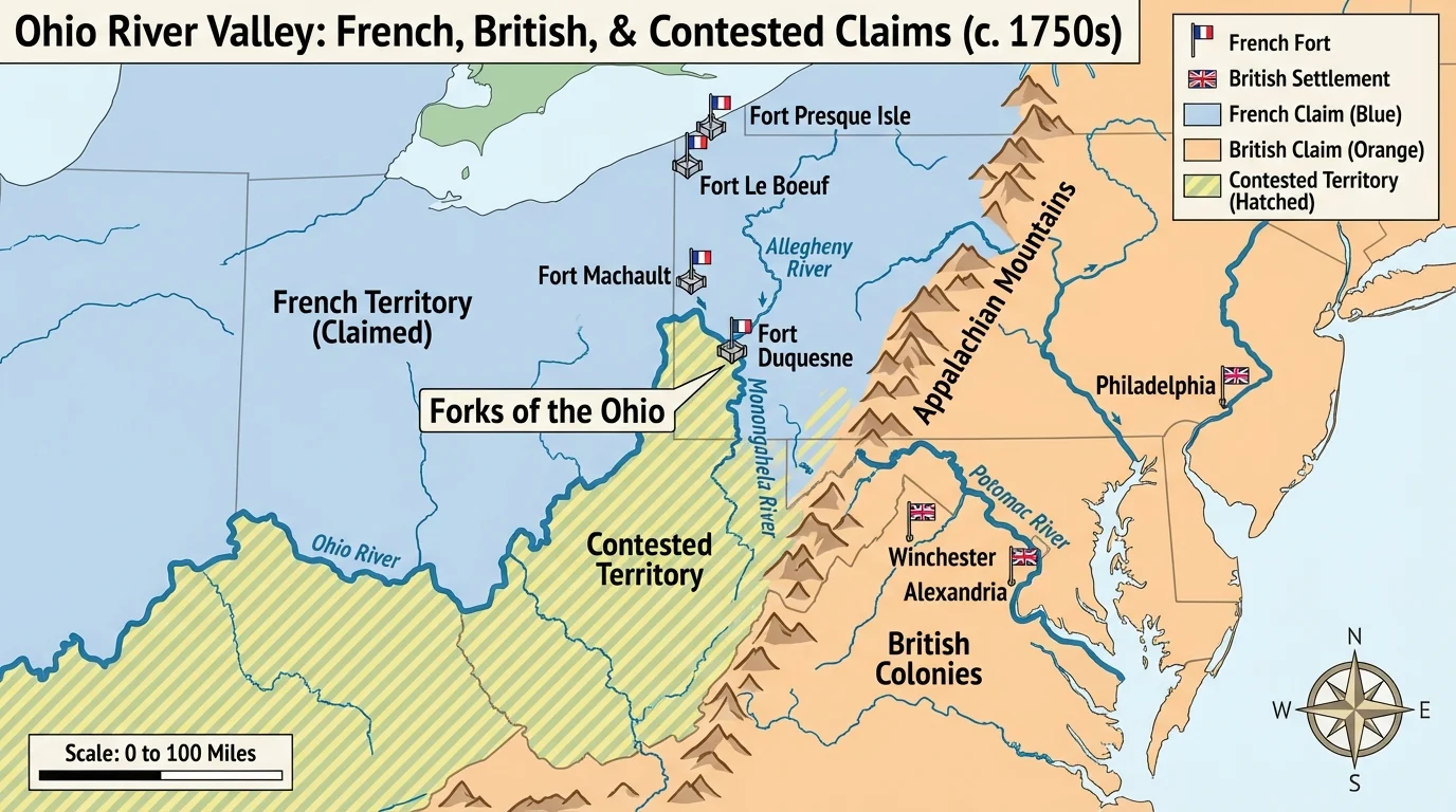
The Ohio River Valley became a major conflict zone because it connected rivers, trade routes, and imperial claims. Control of this interior region mattered greatly, and the river junctions were highly strategic. The French built forts to link Canada to the Mississippi Valley, while the British colonies looked west for land and trade opportunities.
[Figure 4] The Forks of the Ohio, where rivers meet near present-day Pittsburgh, became especially important. A fort there could control movement and commerce. This is one reason the French and Indian War began in this contested region. Geography made the area valuable, and that value drew empires into war.
The war changed early U.S. history in major ways. Britain gained more territory, but it also gained debt. To raise money, Britain taxed the colonies more heavily, which increased colonial anger. So a struggle over interior geography helped create the chain of events that eventually led to the American Revolution.
Case study: Why the Ohio Valley mattered
Step 1: Identify the physical features.
The region contained connected rivers, fertile land, and routes into the interior.
Step 2: Identify the human interests.
French officials wanted to connect their territories; British colonists wanted land and trade; Indigenous nations sought to defend their homelands and political power.
Step 3: Connect geography to the event.
Because the area was a transportation crossroads, control of forts and river junctions became a military priority, helping spark war.
Looking at the war this way helps students see that history is not just a list of dates. It is also a story of people competing within real landscapes.
The American Revolution also had strong regional and environmental connections. Colonial protests grew especially in port cities such as Boston, New York, and Philadelphia. These cities were centers of trade, communication, and political discussion because geography had made them connected places.
Harbors and rivers mattered during the war itself. Armies needed roads, river crossings, and supply lines. Naval power depended on coastlines and ports. The British often controlled coastal areas more easily because of their navy, but controlling the countryside and interior routes was much harder.
Boston is a good example. Its harbor made it an important commercial center, but that same geography also made it a focal point of British enforcement after the Boston Tea Party. New York's location gave it huge strategic value during the war. The Hudson River corridor linked New England to the rest of the colonies, so controlling it could divide the colonies geographically.
Regional geography also affected military campaigns in the South. Swamps, rivers, forests, and long distances shaped troop movements and local support. Settlement patterns mattered too. In more spread-out regions, warfare looked different from warfare in dense port towns.
Earlier geographic patterns remained important here. The river-centered settlements shown in [Figure 2] help explain why transportation and communication in the South differed from those in New England's compact towns and ports.
After independence, attention increasingly turned westward. The Mississippi River system became a vital transportation network for farmers and settlers in the interior. Tributaries connected distant settlements to the main river, and the river flowed south to New Orleans. Whoever controlled that outlet controlled a major economic lifeline.
[Figure 5] Western farmers needed to move crops to market, and river transport was much easier than hauling goods across mountains. This made access to the Mississippi and New Orleans extremely important. The United States worried about foreign control of this trade route because it affected western settlement, national unity, and economic growth.
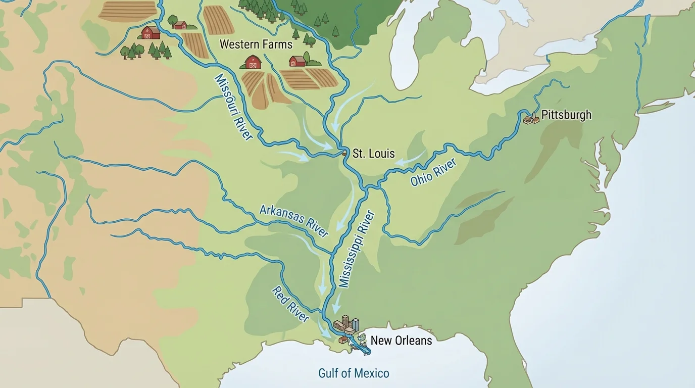
The Louisiana Purchase in 1803 is a perfect example of regional geography shaping history. The United States wanted secure access to New Orleans and the Mississippi. By purchasing Louisiana from France, the nation gained control of a huge interior region and a stronger hold over a key transportation system.
This helped encourage westward expansion, but it also raised major questions about Indigenous lands, slavery's expansion, and the balance of power between regions. The river system was not just a natural feature. It was a political and economic corridor that connected farms, trade, migration, and national policy.
Comparing regions makes the geographic story clearer. New England's harbors, forests, and rocky land encouraged towns, trade, fishing, and shipbuilding. The Middle Colonies' fertile soil and river access encouraged grain farming and large trading cities. The South's warm climate, fertile lowlands, and navigable rivers encouraged plantation agriculture and dispersed settlement. The frontier and interior valleys encouraged migration, conflict, and gradual westward expansion.
| Region | Important Environmental Features | Typical Settlement Pattern | Historical Connections |
|---|---|---|---|
| New England | Rocky soil, forests, good harbors, rich fishing waters | Towns and port cities | Trade, shipbuilding, protest centers in the Revolution |
| Middle Colonies | Fertile soil, navigable rivers, moderate climate | Farms, towns, major cities | Grain production, trade, transportation networks |
| Southern Colonies | Coastal plains, long rivers, warm climate | Dispersed plantations and river settlements | Cash crops, slavery, export economy |
| Backcountry/Interior | Mountains, valleys, river routes, frontier land | Scattered frontier settlements | Westward migration, land conflict, imperial rivalry |
Table 1. Comparison of environmental features, settlement patterns, and historical connections in major early U.S. regions.
This comparison shows that regional differences were not accidental. People adapted to opportunity and constraint. At the same time, they changed the land through farming, logging, roads, ports, and expansion. That is why the relationship between settlement and environment is best understood as an interaction, not a one-way force.
How geography creates historical connections
A region becomes historically important when its physical features influence human decisions and connect places together. Rivers connect farms to ports, mountains redirect migration, and harbors connect colonies to global trade. These links help explain why local environmental conditions can lead to large national events.
The mountain routes in [Figure 3] and the river crossroads in [Figure 4] remind us that geography often shapes where opportunities and conflicts appear first.
To strengthen geographic analysis, historians use both primary sources and secondary sources. A primary source from early U.S. history might be a colonist's letter describing fertile land near a river, a map drawn during a military campaign, or a shipping record from a port city. A secondary source might be a textbook, documentary, or historian's article that explains the broader pattern.
If a colonist wrote that river access made it easier to send tobacco to market, that statement gives direct evidence of human-environment interaction. If a military map shows forts clustered near river junctions, that suggests those places were strategically important. Students should ask what the source reveals about movement, resources, trade, defense, or settlement.
"Geography is the stage on which history is played out."
— Common historical idea
Secondary sources help compare evidence from different places. For example, a historian might use maps, population data, and letters to explain why compact New England towns developed differently from southern plantation districts. Using both kinds of sources allows students to see not only what happened, but also why it happened in certain places.
The broad map in [Figure 1] helps connect all of these examples. Coastal regions, mountain barriers, interior valleys, and river systems were not separate facts. Together, they formed the geographic framework of early U.S. history.