One of the biggest surprises in American history is that many major political arguments were really arguments about geography. Who controlled a river? Who owned fertile soil? Which nation had access to a port, a mountain pass, or a railroad route? Long before airplanes, highways, and satellites, land and resources could decide whether a region became rich, powerful, or vulnerable. To understand the early United States, you have to read history the way a mapmaker, farmer, trader, or military leader would.
The early United States did not simply grow because leaders wanted more territory. Expansion happened because certain places had enormous value. Rivers carried crops to market. Harbors connected trade to the Atlantic world. Forests provided timber for buildings and ships. Mineral resources such as iron and later gold attracted investment and migration. Fertile plains promised new farms. These geographic and environmental features made land worth competing over.
Geography includes physical features such as rivers, mountains, coastlines, climate zones, and soil. Environmental data includes information about rainfall, vegetation, natural resources, and how people use land. Historians study these details because they help explain why people moved, fought, traded, and built settlements where they did.
Geographic data is information about location and physical features, such as maps, rivers, mountains, and borders. Environmental data is information about natural conditions and resources, such as climate, soil, forests, minerals, and water supply. Together, these kinds of evidence help historians explain why people competed for certain places.
For example, the Atlantic coast became an early center of settlement because it had ports and easier access to trade with Europe. The Appalachian Mountains, however, slowed movement westward. The Mississippi River system became crucial because it linked the interior of North America to world markets. Once you notice these patterns, events that may seem political suddenly become geographic as well.
Competition for land was also competition for power. Whoever controlled productive farmland could grow more crops. Whoever controlled transportation routes could move goods faster and more cheaply. Whoever controlled borderlands could influence trade, migration, and military defense. This is why boundary surveys, land purchases, treaties, and railroad construction mattered so much.
When historians interpret the past, they often look at maps the same way scientists look at data charts. A map can show where rivers flow, where cities form, where mountain ranges block travel, and where borders create conflict. Population maps show where people clustered. Climate maps reveal where farming was easier or harder. Transportation maps show which regions were connected and which remained isolated.
Suppose you compare a map of fertile river valleys with a map of population growth. If the same areas grow rapidly, that suggests a link between good farmland and settlement. If you compare railroad maps with maps of coal and iron deposits, you can see why certain industrial regions expanded quickly. Historical geography often works through this kind of comparison.
How to interpret historical maps and data
Ask three questions: Where is the event happening, what resources are nearby, and how can people move through the area? These questions help explain why some regions became centers of conflict or growth. A border in a dry desert, for example, creates different challenges than a border along a navigable river.
Primary sources such as treaties, land surveys, letters, military reports, and travelers' descriptions can be matched with secondary sources such as textbooks and historians' analyses. Together, they help explain not just what happened, but why geography made those events likely.
The Mason-Dixon Line began as a practical solution to a land dispute, and as [Figure 1] shows, it was a surveyed boundary in the mid-Atlantic colonies rather than a random line on a map. In the 1700s, the colonies of Pennsylvania and Maryland had overlapping land claims because earlier charters were unclear. That confusion created tensions over who owned land, who paid taxes there, and which colony had legal authority.
To settle the dispute, surveyors Charles Mason and Jeremiah Dixon carefully measured and marked the boundary. This is an important example of using geographic data in history: boundaries had to be observed, measured, and placed on the landscape. Their work reduced conflict between colonies by making land claims more precise.
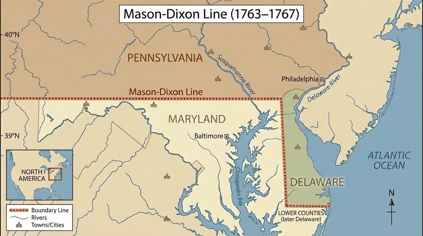
The line later gained a much larger meaning. Over time, it became associated with the division between the North and the South, especially in debates over slavery. The geography of this region mattered because different labor systems and economic patterns had developed on either side. Northern areas generally developed more diversified economies with smaller farms and towns, while southern areas depended more heavily on plantation agriculture.
That difference was tied to land and environment. The southern colonies and states had climates and soils that supported labor-intensive cash crops such as tobacco. As a result, land ownership and enslaved labor became deeply connected. So even though the Mason-Dixon Line started as a boundary survey, it later symbolized a much larger struggle over how land would be used and who would control its wealth. We can still see that deeper meaning when we return to [Figure 1] and notice that a single border can represent both a local dispute and a national divide.
Charles Mason and Jeremiah Dixon used astronomy as well as land measurement to help survey the boundary. Their work reminds us that early mapmaking was both political and scientific.
The Mason-Dixon Line shows that even before the United States expanded westward, competition over land ownership, taxation, and labor systems was already shaping American development.
The Louisiana Purchase was not just a giant land deal; it was a decision about river access, trade, security, and future resources. As [Figure 2] illustrates, the key geographic feature was the Mississippi River, which carried goods from the interior of North America to the port of New Orleans. Farmers west of the Appalachians depended on this route to send crops to market.
When France controlled Louisiana, the United States worried that a powerful foreign nation might block access to New Orleans. President Thomas Jefferson wanted to secure the port because control of trade routes meant control of economic growth. In 1803, the United States purchased the Louisiana Territory from France, doubling the nation's size.
This purchase added vast plains, forests, rivers, and resource-rich lands. It opened the possibility of westward settlement on a huge scale. It also intensified questions that would define the nation's future: Would slavery expand into the new territories? How would the federal government govern such a large space? What would happen to Native nations already living there?
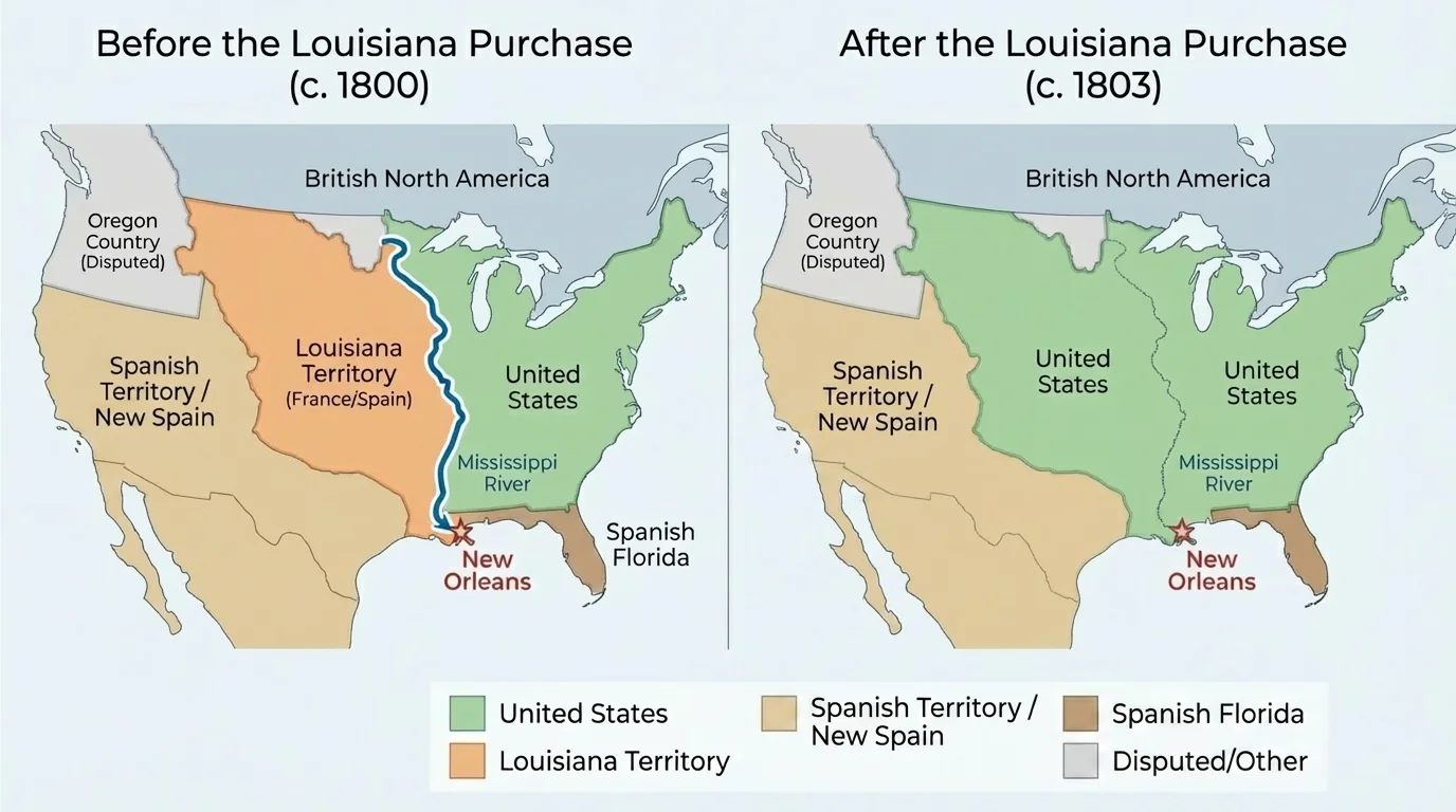
Geographic data helps explain why the purchase mattered so much. If you look at a map of river systems, the Mississippi and its tributaries create a transportation network reaching deep into the continent. Before railroads became dominant, rivers were like highways. Control of that network could shape trade for millions of acres of farmland.
Environmental data matters too. Much of the Louisiana Territory included fertile land suitable for agriculture, as well as forests and animal populations important to trade. Settlers saw opportunity, but expansion also meant conflict. Native peoples faced pressure, treaty violations, forced removal, and loss of hunting lands. Land that looked "empty" on some U.S. maps was actually inhabited and used by many communities in different ways.
Later western exploration, including the Lewis and Clark expedition, gathered information about terrain, rivers, plants, animals, and peoples. That information was geographic data used for political and economic planning. When we study [Figure 2], the size of the purchase stands out, but the river access and resource potential explain why leaders considered it essential.
The rise of the railroads changed the meaning of distance in the United States. Geography still mattered, as [Figure 3] shows, because railroad builders had to deal with mountains, rivers, forests, and long stretches of open land. But unlike river systems, railroads could be planned and laid where leaders wanted stronger connections.
In the early years of the republic, transportation often depended on waterways. That meant some regions had advantages simply because they were near navigable rivers or ports. Railroads began to reduce that disadvantage by linking inland farms, mines, and factories to markets. This helped unify the country economically, but it also created new competition. Towns fought to be included on rail lines because a railroad connection could bring jobs, goods, and population growth.
Resources shaped railroad development too. Building railroads required iron for rails, timber for ties and bridges, and later coal to power locomotives. Regions with access to these resources often industrialized more quickly. Northeastern states, for example, benefited from combinations of manufacturing, port cities, and transportation networks.
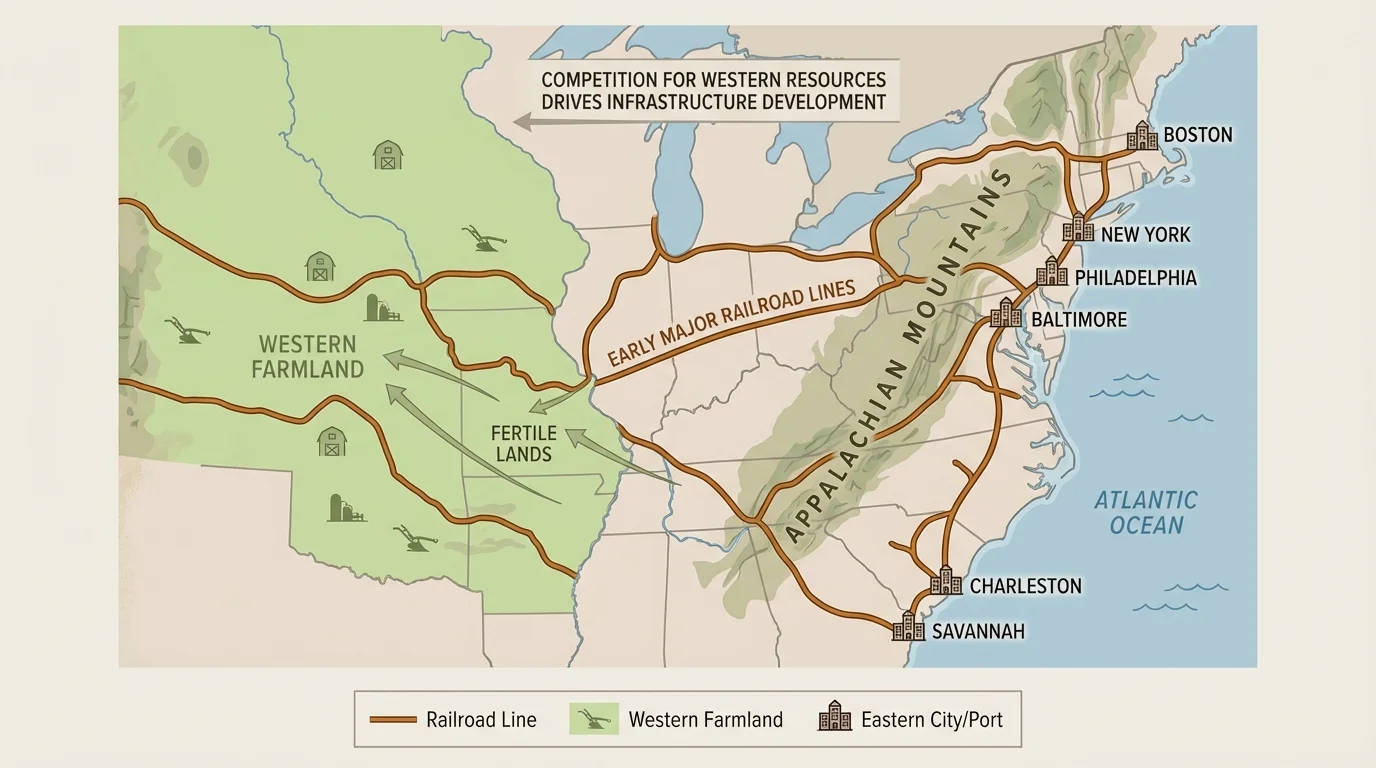
Railroads also increased the value of western land. A farm far from a river might once have been difficult to profit from, but a railroad connection changed that. Land near a station became more desirable. Grain, livestock, and raw materials could be shipped over long distances. This encouraged migration and land speculation, which is the buying of land in hopes that its value will rise.
Case study: Why a railroad route mattered
Consider two farming regions with similar soil and climate.
Step 1: One region is connected to a railroad and the other is not.
The connected region can send crops to a city market more quickly and at lower cost.
Step 2: Buyers and settlers prefer the connected region.
Merchants, grain elevators, and new towns appear along the route.
Step 3: Land values rise near the tracks.
This creates competition to control railroad routes, stations, and nearby land.
This is how transportation geography can shape economic growth.
At the same time, railroad expansion often harmed Native nations by encouraging more settlers to move onto Indigenous lands. It also sharpened sectional arguments about whether new western territories would support slavery or free labor. So the railroad story is not just one of invention and progress; it is also a story of power over land, labor, and resources. Looking again at [Figure 3], we can see that routes did not simply connect places; they helped decide which places would prosper.
The Treaty of Guadalupe Hidalgo ended the Mexican-American War in 1848 and transferred a vast region from Mexico to the United States. As [Figure 4] displays, this land included present-day California, Nevada, Utah, and parts of Arizona, New Mexico, Colorado, and Wyoming. This was one of the largest territorial changes in U.S. history.
Why was this land so important? First, it expanded the United States to the Pacific Coast, giving the nation greater access to Pacific trade. Second, the region contained valuable resources and diverse environments: ports in California, ranching land in the Southwest, mineral wealth in the mountains, and routes for future transportation. The timing mattered too. Soon after the treaty, gold was discovered in California, making the region even more important economically.
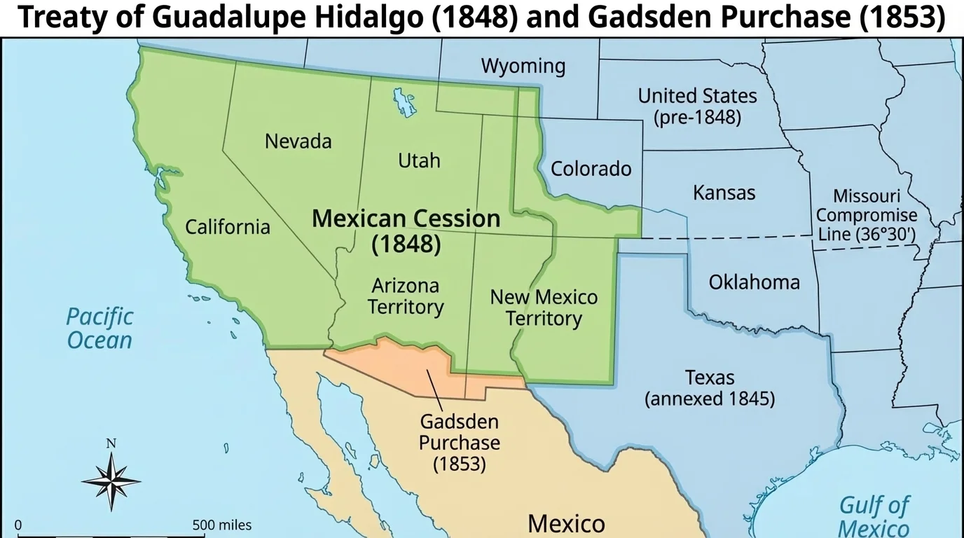
This treaty reveals how military conflict, diplomacy, and geography worked together. The United States wanted not just more land, but strategically useful land. Pacific ports could connect the nation to trade across the ocean. Southwestern routes could support migration and transportation. Dry lands suitable for ranching could support new industries. Mountain regions might contain metals and minerals. Geography gave this territory long-term value.
But this expansion came at great human cost. Mexico lost a huge portion of its territory. Mexicans living in the ceded lands suddenly found themselves inside the United States, often facing discrimination and legal struggles over property rights. Native nations in the region faced additional pressure as U.S. settlement expanded. Competition over land usually meant that some groups gained power while others lost it.
The treaty also intensified the national debate over slavery. Would slavery be allowed in the newly acquired territories? That argument was partly political, but it was also geographic. Different climates, crops, labor systems, and migration patterns affected how these lands might develop. When we examine [Figure 4], the size of the land transfer is striking, but the real historical importance comes from what that land made possible.
Across these examples, a clear pattern appears. The United States developed through repeated competition over land, borders, transportation routes, and resources. The Mason-Dixon Line involved boundary control. The Louisiana Purchase involved rivers and trade access. Railroad development involved transportation corridors, industrial resources, and western markets. The Treaty of Guadalupe Hidalgo involved strategic expansion to the Pacific and control of mineral- and ranching-rich lands.
These events also show that land is never just land. It can be a home, a sacred place, a source of food, a military advantage, or a path to economic growth. Different groups value the same place for different reasons. Settlers might see farmland. A government might see a border to defend. A railroad company might see a route to profit. A Native nation might see ancestral territory connected to culture, hunting, and sovereignty.
| Event | Geographic factor | Resource or advantage | Historical effect |
|---|---|---|---|
| Mason-Dixon Line | Colonial boundary in the mid-Atlantic | Control of land claims and legal authority | Reduced dispute at first; later symbolized sectional division |
| Louisiana Purchase | Mississippi River and interior plains | Trade access, farmland, room for expansion | Doubled U.S. size and accelerated westward growth |
| Railroads | Routes across mountains, plains, and markets | Faster transport, access to coal, iron, timber, and farmland | Connected regions and increased competition for land |
| Treaty of Guadalupe Hidalgo | Southwest and Pacific Coast | Ports, ranching land, minerals, western routes | Expanded U.S. territory and deepened sectional conflict |
Table 1. Comparison of major examples of how geography and resources shaped early U.S. development.
Another major consequence was conflict over slavery and labor systems. As new land entered the nation, people argued about who would work it and under what conditions. This is one reason geographic expansion repeatedly led to political crisis. Control of territory affected the balance of power between regions.
Remember that maps are not neutral. They reflect choices about what to show, what to name, and whose claims to emphasize. A map of "new U.S. territory" may hide the fact that Native nations and Mexican communities already lived there.
Economic development also followed geography. Regions with better transportation links, port access, or extractable resources often grew faster. The environment did not determine everything, but it strongly influenced what was possible and what people fought over.
To study this topic carefully, historians combine many kinds of evidence. A primary source might be a treaty text, a surveyor's notes, a railroad company map, or a letter from a settler describing the land. A secondary source might be a historian's explanation of why a certain route mattered or how expansion affected Native peoples.
Primary and secondary sources in geographic history
A primary source comes from the time being studied, such as a treaty, a map made in the 1800s, or a newspaper report. A secondary source is created later by someone analyzing the past. Using both types helps historians compare firsthand evidence with later interpretation.
For example, if a treaty says a border is fixed at a river, a historian might compare that claim with later maps to see whether the river changed course or whether people disputed the line. If a railroad map shows a route, a historian might compare it with population growth data to see whether towns expanded along the tracks.
This approach helps us avoid oversimplified stories. Instead of saying the United States simply "grew," we can ask better questions. Grew where? At whose expense? Because of which resources? Along which transportation routes? With what environmental advantages or limits? Those questions turn geography into historical explanation.
"Geography is the stage on which history is played out."
— A common historical idea
When we interpret geographic and environmental data, we see that the early United States was shaped not just by ideas and leaders, but by lines surveyed on the ground, rivers leading to ports, tracks laid across difficult terrain, and territories gained through war and treaty. Competition over land and resources was one of the strongest forces in the nation's early development.