Why do some of the world's richest cities spend billions just to keep the sea out, while other communities relocate inland from vulnerable coastal areas? People do not build human systems on a blank surface. Every road, farm, dam, neighborhood, and trade route operates within the limits and opportunities of the physical environment. Mountains block movement, drought reduces crop yields, floods damage infrastructure, and earthquakes force engineers to rethink how buildings stand. Human societies respond creatively, but they never respond in exactly the same way everywhere.
A human system includes the organized ways people live and work, such as cities, transportation networks, agriculture, trade, political boundaries, and energy systems. The physical environment includes landforms, climate, water, soils, ecosystems, and natural hazards. A constraint is a limit or pressure placed on human activity by one or more physical conditions. Geography studies how these forces connect. It is not enough to say that "nature causes problems." Geographers ask which variables matter, how they interact, who is affected, and what responses are most effective.
Constraint means a physical limit or pressure that affects what people can do in a place.
Adaptation is changing behavior, technology, or infrastructure to live with environmental conditions.
Mitigation is reducing the risk or severity of the impacts of a hazard or environmental problem in order to lower future harm.
Resilience is the ability of a community or system to withstand, recover from, and adjust to disruptions.
Sustainability means meeting present needs without damaging the ability of future generations to meet theirs.
One common mistake is to think the physical environment completely determines what happens. That view is too simple. Two places with similar drought risk may respond very differently because of wealth, technology, political organization, or social values. Geography is about interaction: environmental conditions shape choices, but people also reshape environments through dams, irrigation, urban design, land reclamation, and conservation.
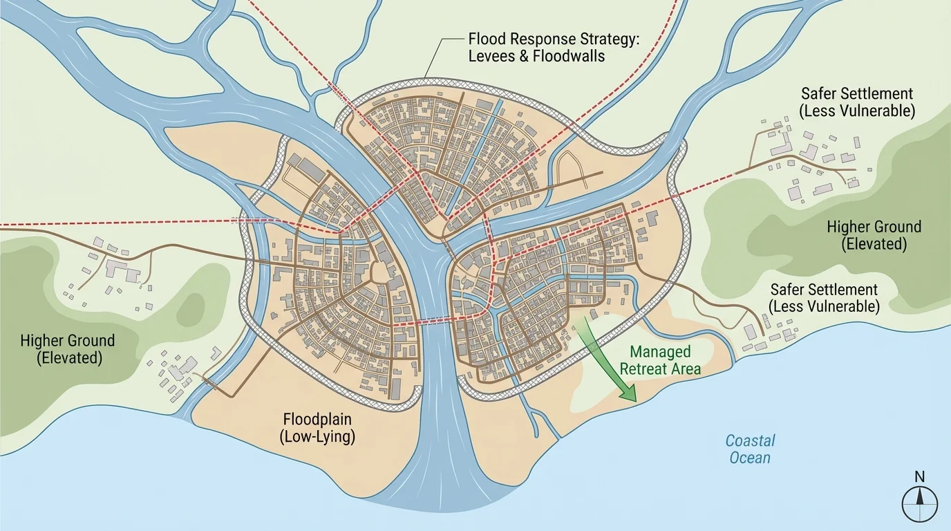
[Figure 1] Physical constraints usually come in combinations. A city may face flood risk because it lies on a low coastal plain, but that risk becomes more serious if storms are frequent, wetlands have been removed, and population density is high. Geographers often study several variables at once rather than isolating only one.
Some of the most important physical variables include climate, water supply, relief, soil quality, vegetation, access to natural resources, and exposure to hazards. Relief refers to differences in elevation and slope. Flat land may support agriculture and transportation more easily than steep terrain, but flat floodplains may also be dangerous places to build. A desert may have open land for solar energy projects, but limited freshwater for large populations.
Climate shapes temperature, precipitation, seasons, and growing conditions. Regions with reliable rainfall can support intensive agriculture more easily than regions with repeated drought. However, too much water can also be a constraint. Monsoon climates support farming but may damage roads, homes, and crops during extreme rains.
Water availability is one of the clearest examples of a constraint on human systems. Cities need water for drinking, sanitation, industry, and energy production. Farms need water for crops and livestock. In arid and semiarid regions, water scarcity can limit settlement size, increase conflict, and force governments to build reservoirs, pipelines, desalination plants, or irrigation systems.
Landforms influence access and movement. Mountain ranges can isolate communities, make transportation expensive, and increase the risk of landslides. At the same time, mountains may provide tourism income, hydropower potential, and freshwater from snowpack. The same environmental feature can be both an opportunity and a constraint depending on the activity.
Natural hazards such as earthquakes, hurricanes, floods, volcanic eruptions, wildfires, and droughts place recurring stress on human systems. Hazard risk depends not only on the event itself, but also on exposure and vulnerability. A strong storm is far more damaging in a crowded coastal area with weak housing than in a sparsely populated area with strong building codes.
The Netherlands has protected large areas of land that lie at or below sea level for centuries. In some places, the environmental constraint is so strong that daily life depends on pumps, dikes, and constant water management.
Resource distribution also matters. Fossil fuels, minerals, fertile soils, forests, and freshwater are unevenly distributed across Earth. This shapes trade, industrial development, and settlement patterns. For example, fertile volcanic soils can support dense populations even where volcanic hazards remain high.
Environmental limits become most visible when we look at actual systems people depend on. Settlement patterns are heavily influenced by access to water, moderate climate, flat land, and safety from hazards. Large populations tend to cluster in river valleys, coastal zones, and plains because these areas support transport and agriculture. Yet these same advantages can increase flood and storm risk.
Agriculture depends on temperature, rainfall, soil fertility, length of growing season, and topography. Farmers respond to environmental constraints by changing crops, using irrigation, terracing slopes, rotating fields, or adopting drought-resistant seeds. In some places, environmental limits are so strong that farming remains low-yield or highly risky.
Transportation systems must work with terrain. Building a highway or railway across steep mountains costs far more than building on plains. Rivers can serve as transportation corridors, but they may also require bridges, flood control, or seasonal planning. Sea ice, storms, and desert heat can all interfere with movement of goods and people.
Energy systems are also constrained geographically. Hydropower needs reliable flowing water and elevation change. Solar power is strongest in sunny regions. Wind farms work best in consistently windy locations such as coasts, open plains, or mountain passes. Even energy choices are tied to physical geography.
Public health can be affected by environment as well. Flooding can contaminate water supplies. Heat waves can strain power grids and threaten vulnerable populations. Drought can reduce food production and increase malnutrition. Wildfire smoke can worsen respiratory disease over wide regions.
Migration often reflects environmental pressure. People may move temporarily after disasters or permanently when land becomes too dry, too flood-prone, or too unstable for livelihoods. Environmental migration usually has multiple causes, but physical constraints can be a major trigger.
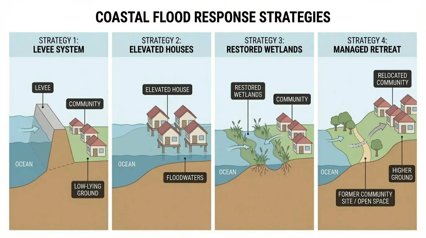
Communities respond to environmental limits in different ways depending on scale, wealth, technology, and political goals. Some strategies try to resist nature, some try to work with it, and some involve changing where and how people live. The range of options becomes clearer when we compare structural defenses, ecological approaches, and relocation choices, as [Figure 2] illustrates in the context of flood risk.
One major strategy is adaptation. Adaptation includes actions such as elevating buildings in flood zones, planting drought-tolerant crops, designing earthquake-resistant buildings, changing planting calendars, or improving insulation during extreme heat and cold. Adaptation accepts that a physical constraint exists and aims to function within it.
Another strategy is engineering and infrastructure. Examples include levees, seawalls, dams, reservoirs, tunnels, irrigation canals, avalanche barriers, and stormwater drainage systems. These approaches can reduce risk quickly and protect large populations, but they are often expensive and can create new environmental problems. A dam can improve water security and hydroelectric production while also displacing communities and disrupting river ecosystems.
Ecosystem-based strategies work with natural processes. Wetland restoration can absorb floodwater. Mangrove forests can reduce storm surge energy along tropical coasts. Reforestation on slopes can reduce erosion and landslides. These strategies may be slower to establish, but they can provide multiple benefits at once, including biodiversity protection and improved water quality.
Policy and planning are just as important as physical construction. Zoning laws can prevent building in hazard-prone locations. Water pricing can encourage conservation. Evacuation plans, hazard maps, and early warning systems improve preparedness. Building codes can require stronger structures in earthquake or hurricane zones.
Sometimes the best response is managed retreat, which means moving people and infrastructure away from high-risk places. This is often politically difficult because people are deeply attached to homes, jobs, and cultural landscapes. However, in some areas repeated rebuilding may cost more over time than relocation.
Technology also expands the range of responses. Satellite monitoring, geographic information systems, drought forecasting, flood modeling, desalination, precision agriculture, and climate-resilient construction materials all help societies respond more effectively. Still, technology does not erase geography. It changes what is possible, but cost, access, and environmental side effects still matter.
Response strategies exist on a spectrum. At one end, people try to defend existing systems through hard infrastructure like seawalls or reservoirs. In the middle, they adjust systems through adaptation, better planning, and flexible land use. At the other end, they transform systems through relocation, economic change, or major redesign. Geographic decision-making often involves moving along this spectrum over time as conditions change.
The same place may use several strategies at once. A coastal city may combine sea barriers, wetland restoration, updated evacuation routes, stricter zoning, and raised buildings. This mixed approach is often more realistic than relying on a single solution.
[Figure 3] Choosing a response is not just about asking what works physically. Geographers evaluate responses using several criteria at once. A strategy can be effective in reducing risk but still be too costly, unfair, or environmentally damaging.
Important evaluation criteria include effectiveness, cost, equity, environmental impact, time horizon, and scalability. Effectiveness asks whether the strategy actually reduces the constraint. Cost includes not only construction but maintenance and long-term operation. Equity asks who benefits and who bears the burden. Time horizon distinguishes short-term emergency fixes from solutions that remain useful for decades.
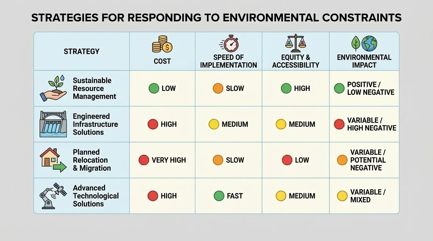
Environmental impact matters because one solution can worsen another problem. A seawall may protect expensive urban property but increase erosion elsewhere. Intensive irrigation may increase crop production in the short run but deplete groundwater over time. A sustainable response tries to reduce risk without undermining the future.
Scale matters too. A household can store emergency supplies and elevate appliances, but only governments can build regional flood barriers or redesign national water policy. Some responses work at the local scale while others require national or international coordination.
Case evaluation: a flood-prone river city
A city is deciding among four options: build higher levees, restore upstream wetlands, raise homes in the highest-risk neighborhoods, or relocate the most exposed residents.
Step 1: Compare effectiveness.
Higher levees may reduce frequent floods quickly, but they can fail during extreme events. Wetlands absorb water more naturally, though benefits may take time to develop. Raised homes reduce property damage but do not protect roads or utilities. Relocation removes exposure almost completely for the people who move.
Step 2: Compare equity.
If only wealthy neighborhoods can afford raised homes, the strategy is less equitable. If relocation payments are too low, low-income residents may suffer most. Wetland restoration may spread benefits more broadly if it protects multiple communities.
Step 3: Compare long-term sustainability.
Levees require maintenance and may encourage more building in risky places. Wetlands improve habitat and water quality as well as flood protection. Relocation may be costly now but reduce repeated disaster losses later.
A strong recommendation might combine restored wetlands, targeted home elevation, and selective relocation rather than relying only on taller levees.
[Figure 4] As in [Figure 2], no single response solves every flood problem. Effective evaluation usually leads to layered strategies rather than one dramatic intervention.
Geographic responses become easier to understand when compared across very different places. These examples span low-lying deltas, dry grasslands, seismic islands, and desert cities. The key pattern is that strategies must fit local physical conditions and human realities.
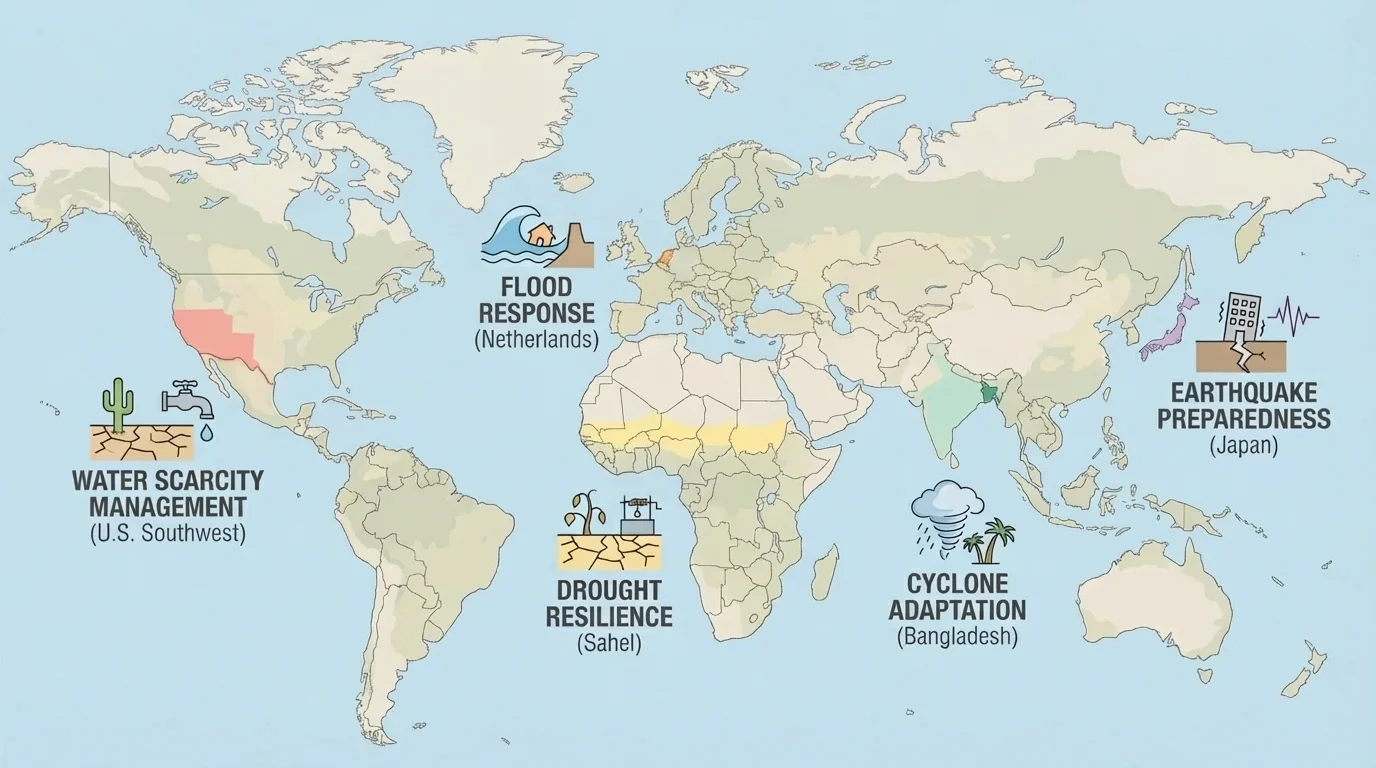
The Netherlands: Much of the country lies near or below sea level, so flooding is a constant constraint. Dutch strategies include dikes, storm-surge barriers, pumps, carefully planned canals, and projects that deliberately give rivers more space during high water. This is a strong example of combining engineering with environmental planning. Instead of only blocking water, some projects redesign landscapes to manage it more safely.
The Sahel: The Sahel, south of the Sahara, faces low and variable rainfall, drought, and land degradation. Human systems such as pastoralism and farming are highly sensitive to water availability. Responses include drought-resistant crops, water harvesting, tree planting, improved grazing management, and early warning systems. These strategies are often low-cost compared with massive engineering works, but they depend heavily on local knowledge and long-term cooperation.
Japan: Japan experiences earthquakes, tsunamis, steep terrain, and limited flat land for large cities. Building codes are among the strongest in the world, transportation systems are designed with hazard awareness, and coastal protections exist in some areas. Yet major disasters still occur. Japan shows that even highly advanced societies cannot eliminate physical constraints; they can only reduce vulnerability and improve resilience.
The U.S. Southwest: Cities such as Phoenix, Las Vegas, and parts of southern California face water scarcity, heat, and long-term drought. Strategies include reservoirs, interstate water transfers, groundwater pumping, desalination in some connected regions, water-saving technology, recycling wastewater, and changing landscaping to reduce use. But these solutions also raise questions of sustainability, especially where demand grows faster than supply.
Bangladesh: Bangladesh faces river flooding, cyclones, storm surges, and dense population in low-lying delta regions. Responses include cyclone shelters, raised roads, flood forecasting, community warning systems, embankments, and adapted agricultural practices. Bangladesh demonstrates that communication and preparedness can save many lives even when hazards cannot be prevented.
"There is no such thing as a natural disaster; there are natural hazards, and there are human vulnerabilities."
— Common principle in hazard geography
This principle matters because it shifts attention from the hazard alone to the interaction between environment and society. A hurricane becomes far more destructive when housing is weak, warning systems fail, or wetlands have been removed.
Identifying and evaluating strategies is only part of the task. Students, planners, and citizens must also communicate recommendations clearly. Good geographic communication explains the physical constraint, shows who is affected, compares options, and supports conclusions with evidence. A strong explanation usually includes maps, hazard zones, climate records, population patterns, and infrastructure data.
When communicating, it helps to organize evidence around a few guiding questions: What is the constraint? Which human systems are affected? What geographic variables reduce or intensify the problem? What response options exist? Which option or combination of options is most effective, equitable, and sustainable?
Clarity matters because different audiences need different kinds of explanation. Engineers may want detailed hazard probabilities and design thresholds. Community members may want clear evacuation routes, local costs, and property impacts. Government leaders may focus on budget, long-term risk reduction, and political feasibility. Effective communication adjusts to audience without reducing accuracy.
Maps are especially powerful because they show spatial relationships that words alone may hide. A hazard map can reveal that the most flood-prone neighborhoods are also the least wealthy, changing the conversation from simple protection to environmental justice. Data tables can compare costs and outcomes. Short written claims can connect evidence to recommendations.
| Strategy | Main advantage | Main limitation | Best use |
|---|---|---|---|
| Hard infrastructure | Fast protection for large areas | High cost; possible environmental side effects | Dense cities and critical infrastructure |
| Ecosystem-based response | Multiple environmental benefits | May take time to establish | Flood control, erosion reduction, coastal protection |
| Planning and policy | Can reduce future exposure | Requires enforcement and public support | Land use, zoning, building safety |
| Managed retreat | Greatly reduces repeated risk | Politically and socially difficult | Areas with severe recurring hazard |
| Technological adaptation | Improves efficiency and monitoring | May be expensive or unevenly available | Water management, forecasting, farming |
Table 1. Comparison of common strategy types used to respond to environmental constraints.
A well-argued geographic recommendation often sounds like this: Because this coastal district is low-lying, densely populated, and repeatedly flooded, a combined strategy of wetland restoration, stricter zoning, and selective elevation of buildings is more sustainable than relying only on a seawall. Notice that this statement connects physical variables, human systems, and evaluation criteria in one clear claim.
Physical environments change over time. Sea level rises, river channels shift, drought patterns intensify, forests burn, and cities expand into risky land. That means strategies must also change. A plan that worked for twenty years may fail under new conditions. This is why adaptive management is so important: decisions should be monitored, revised, and improved as new evidence appears.
Trade-offs are unavoidable. Protecting one place may transfer risk to another. Expanding irrigation may save crops but strain ecosystems. Rebuilding after disasters may preserve local identity while also locking people into recurring danger. Geography does not usually offer perfect answers. It offers better and worse responses, based on evidence.
As seen earlier in [Figure 1], environmental constraints operate through location and spatial relationships, not isolated facts. And as the case studies in [Figure 4] demonstrate, strategies that succeed in one region may fail in another if climate, landforms, resources, population density, or governance differ. The most persuasive geographic thinking recognizes both shared patterns and local uniqueness.
The central challenge is not to defeat the physical environment, but to build human systems that respect its limits while protecting human life, economic activity, and ecological health. That is the heart of identifying, evaluating, and communicating strategies in geography.