A volcanic eruption in Indonesia in 1815 altered climate patterns around the world, helped cause crop failures in multiple regions, and contributed to hunger, disease, and migration. That single event reminds us of something easy to forget: human history is not shaped only by kings, inventions, or wars. It is also shaped by a restless planet. Earthquakes, eruptions, droughts, floods, and tsunamis have repeatedly altered where people live, how many survive, and why communities move.
To understand these changes, we need to think of Earth as a connected system. The solid Earth, oceans, atmosphere, ice, and living things interact constantly. A geologic event may begin deep below the surface, but its effects can reach farms, ports, water supplies, governments, and families. Sometimes the impact is immediate and dramatic. In other cases, the effects build over years until migration becomes the only realistic choice.
The surface of Earth changes because energy moves through the planet. Heat from Earth's interior drives movement in the mantle, which helps move tectonic plates. Energy from the Sun drives weather, climate, and the water cycle. Gravity pulls rock, water, and sediment downhill. Together, these processes create a world that is active rather than fixed.
Human societies often develop in places that are productive but risky. River valleys provide fertile soil, but they flood. Volcanic regions can have rich farmland, but they can also erupt. Coastal plains support trade and fishing, but they face tsunamis, hurricanes, and sea-level rise. Some of the most attractive places to settle are also some of the most hazardous.
Natural hazard is a natural process or event that can harm people, property, or ecosystems. A disaster occurs when that hazard actually causes major damage or loss, especially when a population is highly exposed and vulnerable.
Population size refers to the number of people in a given area, while migration is the movement of people from one place to another, either temporarily or permanently.
This distinction matters. An earthquake under the ocean is a hazard. If it generates a tsunami that strikes a densely populated coast, destroys infrastructure, and causes deaths, it becomes a disaster. The same physical event can have very different outcomes depending on where it happens and how prepared people are.
Earth-related hazards include both sudden events and slow-building changes. Some are mainly geologic, such as earthquakes, volcanic eruptions, tsunamis, and landslides. Others involve interactions between geology, climate, and water, such as floods, droughts, wildfires, and dust storms. Some hazards are triggered by one another. An earthquake can trigger a tsunami or a landslide. A volcanic eruption can send ash into the atmosphere and also melt ice, causing floods.
An earthquake happens when built-up stress in Earth's crust is released suddenly, sending out seismic waves. A volcanic eruption occurs when magma, gases, and ash reach the surface. A tsunami is a series of large ocean waves usually caused by undersea earthquakes, volcanic eruptions, or landslides. A drought is a long period of unusually low rainfall that creates water shortages and often food insecurity.
Not every hazard kills people directly. Drought may lead first to crop failure, then to malnutrition, rising food prices, disease, and displacement. Flooding may contaminate water supplies and spread illness after the water recedes. In other words, the pathway from hazard to human impact is often more complex than the event itself.
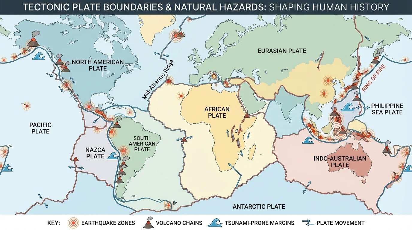
Many major hazards cluster along tectonic plate boundaries, as shown in [Figure 1]. Earth's outer shell is broken into moving plates. Where plates collide, separate, or slide past one another, stress and heat produce earthquakes and volcanoes. Subduction zones, where one oceanic plate sinks beneath another plate, are especially important because they can generate powerful earthquakes, explosive volcanoes, and tsunamis.
For example, when stress along a fault is suddenly released, the ground shakes. If that movement lifts or drops the seafloor, it displaces water and can launch a tsunami across an ocean basin. Volcanic eruptions occur when magma rises because it is less dense than the surrounding rock, and dissolved gases expand as pressure decreases near the surface.
Other hazards are tied more directly to climate and surface processes. Heavy rainfall can saturate slopes and trigger landslides. Long-term shifts in atmospheric circulation can produce severe droughts. Snowmelt and intense storms can increase flood risk. Even when a hazard seems purely climatic, geology still matters because rock type, slope angle, soil thickness, and drainage strongly affect what happens on the ground.
Scientists often describe an earthquake's released energy with the logarithmic moment magnitude scale. Because the scale is logarithmic, a difference of one whole number represents a large increase in released energy. A simple approximation is that the energy ratio between two magnitudes differs by about a factor of \(32\). For example, an earthquake of magnitude \(8\) releases about \(32\) times more energy than one of magnitude \(7\), and about \(32 \times 32 = 1{,}024\) times more than one of magnitude \(6\). That helps explain why very large earthquakes can have global historical effects.
The ash cloud from a major volcanic eruption can circle the planet and affect climate far from the volcano itself. Tiny particles in the atmosphere can reflect sunlight and temporarily cool Earth's surface.
The same tectonic settings shown earlier in [Figure 1] also help explain why the Pacific "Ring of Fire" contains so many active volcanoes and frequent earthquakes. This is not random geography; it is a pattern produced by Earth's internal dynamics.
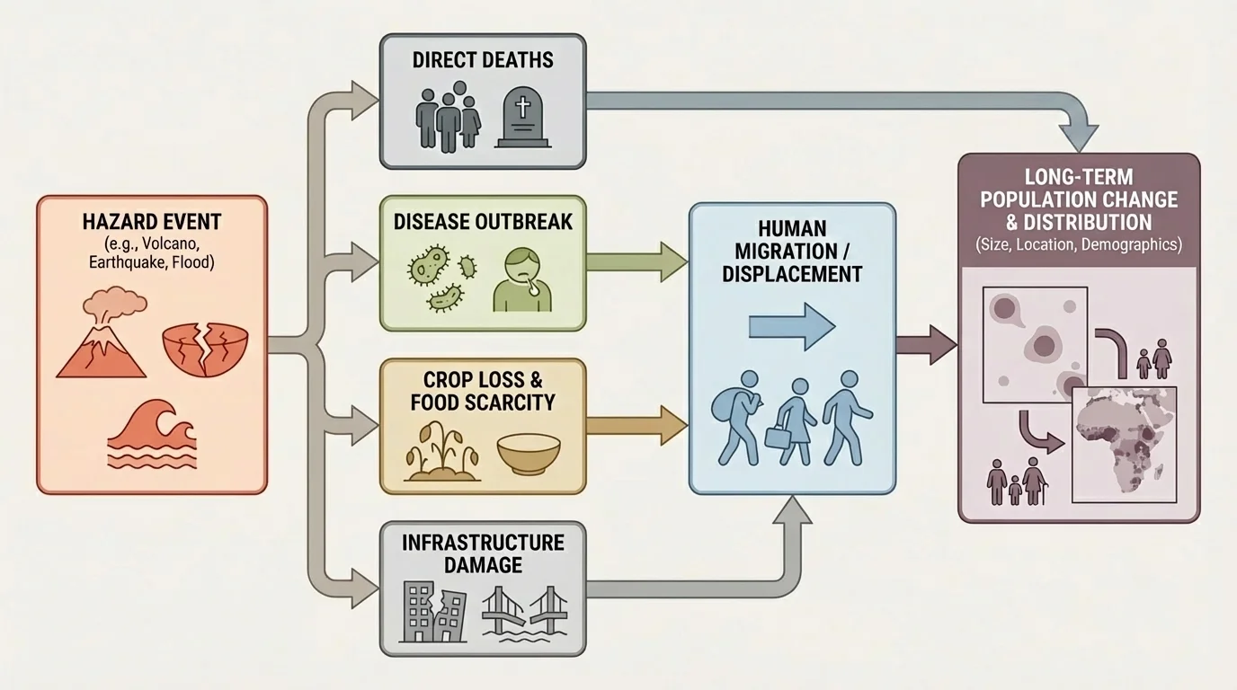
A single event can affect population size through several pathways, as [Figure 2] illustrates. The most obvious pathway is direct mortality: deaths caused immediately by shaking, ashfall, fire, flooding, or building collapse. But indirect effects may continue long after the event ends.
After a disaster, damaged water systems can spread disease. Food shortages can weaken immune systems. Hospitals may be destroyed, reducing medical care. Roads and ports may be blocked, slowing outside help. In some cases, birth rates fall because families delay having children during periods of uncertainty or hardship.
Population size can also decline through out-migration. If a region loses jobs, farmland, homes, or water supplies, many people leave. Even if they survive, the local population can shrink sharply. In other cases, populations later recover or even grow again if rebuilding creates jobs and stronger infrastructure.
These demographic changes are not always short term. The 1815 eruption of Mount Tambora in Indonesia injected so much material into the atmosphere that 1816 became known in parts of Europe and North America as the "Year Without a Summer." Crop failures contributed to food shortages, economic stress, and migration. The eruption did not just affect the island near the volcano; it altered population patterns across regions far away.
Another example is drought. A prolonged drought may not produce dramatic footage like an earthquake, but it can gradually reduce carrying capacity, the number of people an environment can support. If crops fail year after year, livestock die, and groundwater drops, mortality can rise while migration increases. The result is still a major population shift.
Disasters are social as well as natural. The physical event matters, but so do housing quality, poverty, public health, emergency response, and access to resources. The same storm or earthquake can cause very different death rates in two places because vulnerability is different.
That is why a hazard does not automatically produce the same outcome everywhere. A magnitude \(7\) earthquake in a region with strict building codes may kill far fewer people than a weaker quake in a place with poorly built structures and limited emergency response.
Hazards can trigger both short-term evacuation and long-term relocation. Some people leave only until immediate danger passes. Others never return because homes, farmland, or jobs are gone. Migration can happen within a country or across borders, and it can be voluntary, pressured, or forced.
Displacement occurs when people are forced to leave where they live, often quickly. Afterward, some enter temporary shelters, some move in with relatives, and some resettle permanently. Coastal fishing villages struck by tsunamis may move inland. Communities near volcanoes may be relocated outside exclusion zones. Farmers facing repeated drought may move to cities in search of work.
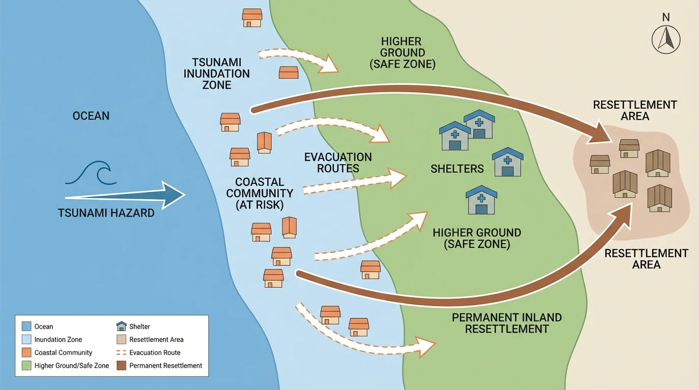
[Figure 3] Migration caused by hazards often interacts with economics and politics. If a city receives many newcomers after a rural drought, housing prices may rise, jobs may become scarce, and social tension may increase. At the same time, migrants may bring labor, knowledge, and cultural change. Hazard-driven migration is therefore both an environmental issue and a social one.
The pattern in [Figure 3] helps distinguish evacuation from long-term migration. Evacuation is usually fast and temporary; migration often involves rebuilding a life elsewhere. This difference matters when governments plan shelters, schools, transportation, and healthcare.
Case example: drought and movement to cities
Suppose a farming region normally supports \(500{,}000\) people, but repeated drought cuts crop production by roughly half.
Step 1: Recognize the environmental change
Lower rainfall means less soil moisture, lower river flow, and less reliable harvests.
Step 2: Trace the human effects
Food becomes more expensive, farm income falls, and debt increases. Some families can no longer remain on the land.
Step 3: Predict migration
If even \(20\%\) of the population leaves, then \(0.20 \times 500{,}000 = 100{,}000\) people migrate, placing new demands on nearby towns and cities.
This simplified example shows how an environmental hazard can become a demographic and economic event.
Over long periods of history, repeated hazards can reshape entire settlement patterns. If one valley floods catastrophically every few decades, populations may gradually shift to higher ground. If a coastline experiences repeated storm damage or saltwater intrusion, inland migration may become more common over generations.
The events in [Figure 4] span different centuries but reveal similar patterns: a physical event disrupts resources and infrastructure, populations decline or move, and societies adapt unevenly. Looking closely at case studies helps connect Earth science to historical change.
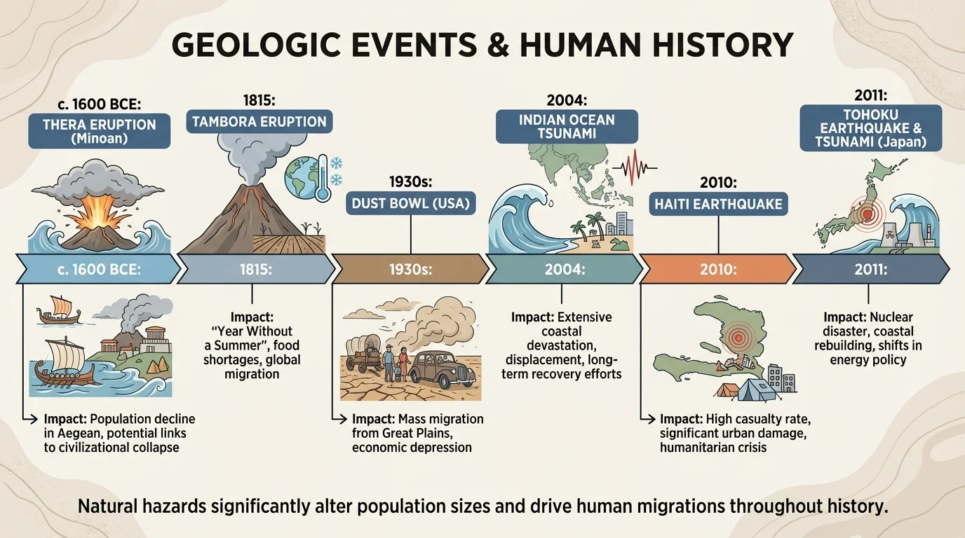
One famous ancient example is the eruption of Thera, on the island of Santorini, in the eastern Mediterranean. Although historians still debate the exact scale of its political consequences, the eruption likely affected trade networks and coastal communities in the Bronze Age Aegean. Ashfall, tsunamis, and regional disruption would have made life difficult for nearby populations.
In Roman history, the eruption of Mount Vesuvius in 79 CE buried Pompeii and Herculaneum. This event did not transform the entire Roman world demographically, but it provides clear evidence of how quickly a prosperous urban area can be destroyed by volcanic hazards. Archaeology shows the direct human toll in remarkable detail.
The 1815 eruption of Tambora had much larger global consequences. Reduced sunlight and cooler temperatures hurt harvests in multiple regions. Famines and disease outbreaks followed in some places. Economic hardship encouraged migration, including movement within North America. A geologic event in one location became a global social stress.
The Dust Bowl of the 1930s in the United States illustrates how drought, wind erosion, and land-use choices can combine into a major migration event. Severe drought struck the Great Plains, but farming practices had also left soil exposed. Strong winds removed topsoil, creating dust storms that damaged health and agriculture. Hundreds of thousands of people left the region, many moving west to California. This was not a sudden geologic disaster like an earthquake, yet it powerfully reshaped population patterns.
The 2004 Indian Ocean tsunami began with a massive undersea earthquake near Sumatra. Tsunami waves struck many coastlines across the Indian Ocean, killing more than 200,000 people and displacing many more. Fishing communities, tourist areas, and ports were devastated. Because tsunamis can cross entire ocean basins, this event showed how one tectonic rupture can become an international humanitarian crisis.
The 2010 Haiti earthquake demonstrated the importance of vulnerability. The earthquake itself was severe, but the extreme destruction was linked to weak buildings, dense urban population, and limited infrastructure. In contrast, the 2011 Tohoku earthquake and tsunami in Japan also caused enormous loss, yet Japan's preparedness, engineering, and warning systems reduced some risks even though the disaster remained catastrophic. These broad historical patterns remind us that outcomes depend on both Earth processes and human systems.
| Event | Main hazard | Human impacts | Migration effect |
|---|---|---|---|
| Thera eruption | Volcanic eruption and possible tsunamis | Regional trade and settlement disruption | Likely relocation in affected coastal areas |
| Tambora, 1815 | Volcanic eruption | Global cooling, crop failure, famine, disease | Regional and international migration increased |
| Dust Bowl, 1930s | Drought and dust storms | Farm collapse, health problems, poverty | Large-scale internal migration in the U.S. |
| Indian Ocean, 2004 | Tsunami | Mass death, infrastructure loss, displacement | Temporary and permanent relocation |
| Haiti, 2010 | Earthquake | High mortality, homelessness, disease risk | Major displacement from damaged areas |
| Tohoku, 2011 | Earthquake and tsunami | Deaths, infrastructure damage, nuclear crisis | Evacuation and long-term exclusion zones |
Table 1. Selected hazard events and their effects on human populations and migration.
Disaster risk depends on more than the event itself, as [Figure 5] shows. A useful way to think about risk is to consider three major factors: the hazard itself, exposure, and vulnerability. Exposure means people and property are in harm's way. Vulnerability means they are likely to be badly harmed if the event occurs.
We can express this idea in a simplified relationship: \(\textrm{risk} \approx \textrm{hazard} \times \textrm{exposure} \times \textrm{vulnerability}\). This is not a precise universal equation, but it helps organize thinking. For example, if a coastal city faces a tsunami hazard, risk rises when many people live in low-lying areas and when buildings, warning systems, and evacuation routes are weak.
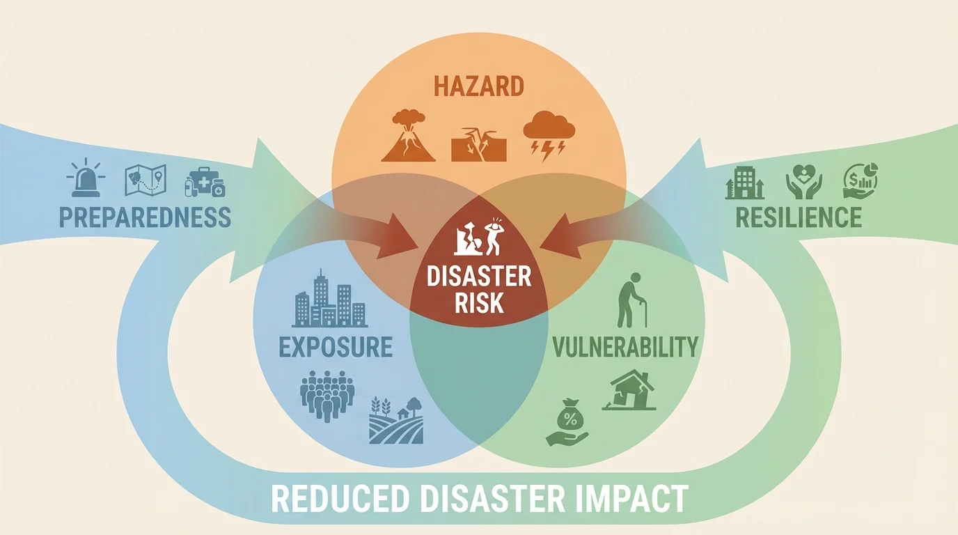
Consider a simple numerical example. If one town has relative hazard \(4\), exposure \(5\), and vulnerability \(5\), its risk index is \(4 \times 5 \times 5 = 100\). If another town faces the same hazard but reduces vulnerability to \(2\) through stronger buildings and planning, the index becomes \(4 \times 5 \times 2 = 40\). The hazard did not change, but the likely harm dropped sharply.
Recall that Earth systems interact. A tectonic event can affect the hydrosphere and biosphere; a drought can affect soil, food webs, and the economy. Thinking in systems helps explain why disasters spread through many parts of society.
Risk reduction includes earthquake-resistant design, tsunami warning networks, volcanic monitoring, floodplain management, drought planning, and public education. Scientists monitor seismic activity, ground deformation, gas emissions, rainfall, river levels, and satellite data to detect warning signs. Engineers design buildings to flex rather than collapse. Governments can limit construction in high-risk zones.
Resilience means the ability of a community to prepare for, respond to, and recover from hazards. Wealth matters, but planning and trust also matter. A poorer community with strong local networks and effective warnings may recover better than a wealthier one with weak institutions.
Natural hazards are natural, but disasters are often amplified by human decisions. Building dense settlements on unstable slopes increases landslide risk. Removing coastal wetlands reduces protection from storm surge. Overpumping groundwater can cause land subsidence, making flood damage worse. Poor land management can intensify dust storms and erosion.
Climate change is also altering hazard patterns. Warmer air can hold more water vapor, increasing the potential for intense rainfall in some regions. Hotter conditions can worsen drought and wildfire risk in others. Melting ice and thermal expansion contribute to sea-level rise, increasing coastal flooding. These changes do not replace geologic hazards, but they interact with them and can deepen migration pressures.
Real-world application: early warning saves lives
Japan's earthquake early warning system detects fast-moving seismic waves and sends alerts before the strongest shaking arrives in some locations.
Step 1: Sensors detect the first waves
These waves travel quickly and provide information about the earthquake's location and size.
Step 2: Alerts are sent automatically
Phones, trains, and factories can receive warnings in seconds.
Step 3: People and systems respond
Trains slow down, surgeries pause, and people move away from dangerous objects.
Even a warning of only a few seconds can reduce injuries and damage because risk depends on preparation as much as on the event itself.
The interaction shown earlier in [Figure 5] explains why future hazard impacts will depend heavily on where people build, how they manage resources, and whether they invest in resilience. Population growth in hazardous coastal and seismic regions can increase disaster potential even if the hazards themselves remain constant.
Across history, natural hazards and other geologic events have repeatedly changed the size and distribution of human populations. Some events cause sudden mortality. Some reduce food production and increase disease. Some destroy infrastructure and trigger displacement. Others slowly push people away from landscapes that no longer support them.
This is why Earth science belongs in the study of human history. Settlement patterns, trade routes, state stability, agricultural success, and migration flows are all influenced by the planet's physical processes. From ancient eruptions to modern tsunamis, the story is consistent: a dynamic Earth shapes where and how people live.
Understanding these patterns is not only about the past. It helps societies prepare for the future. The better we understand hazards, exposure, vulnerability, and resilience, the better we can reduce losses and support communities facing environmental change.