A snowy village in Alaska, a crowded neighborhood in Mexico City, a farming town high in the Andes, and a fishing community in the Caribbean may all be part of the Western Hemisphere, but they are very different from one another. That difference is not random. The land, climate, water, resources, history, and people of a place help shape how people live and how they think about who they are. Geography is not just about maps. It helps explain identity, culture, and the choices people make every day.
Every place has a combination of physical features and human features. Physical features include mountains, rivers, deserts, climate, and natural resources. Human features include cities, roads, farms, languages, religions, and traditions. Together, these characteristics influence what people eat, how they build homes, how they travel, what jobs they do, and how they connect to their communities.
Human identity is shaped by more than one factor. A person may identify with a country, a city, an Indigenous nation, a language group, a religion, or a region. In many cases, these identities are linked to geography. Someone living on a Caribbean island may develop a strong connection to the sea. A person growing up in the Andes may identify with mountain traditions, highland farming, and local Indigenous heritage. A ranching family on the Great Plains may connect its identity to open grasslands and agricultural life.
Physical characteristics are natural features of Earth such as landforms, climate, vegetation, and water.
Human characteristics are features created by people or shaped by human activity, such as language, religion, population patterns, cities, and economic systems.
Culture includes the beliefs, customs, arts, foods, languages, and traditions shared by a group of people.
Identity is the way people see themselves and the groups or places they feel connected to.
When geographers study a region, they ask questions such as: What is the land like? What resources are available? Who lives there? How have people adapted to the environment? How do different groups view the same place? These questions help reveal why regions in the Western Hemisphere are so diverse.
[Figure 1] The Western Hemisphere stretches from the Arctic in the north to the southern tip of South America. Because it covers such a large area, it includes very different physical environments, with mountains, plains, islands, deserts, forests, and rivers shaping where people settle and how they live.
Some of the most important landforms are mountain ranges, plains, plateaus, islands, river systems, and coastal zones. The Rocky Mountains run through western North America, while the Andes stretch along the western edge of South America. The Great Plains of North America support major farming and ranching. The Amazon Basin contains tropical rainforest and one of the world's largest river systems. The Caribbean includes many islands where coastal living and maritime trade are important. Farther north, Arctic regions have tundra and long, cold winters.
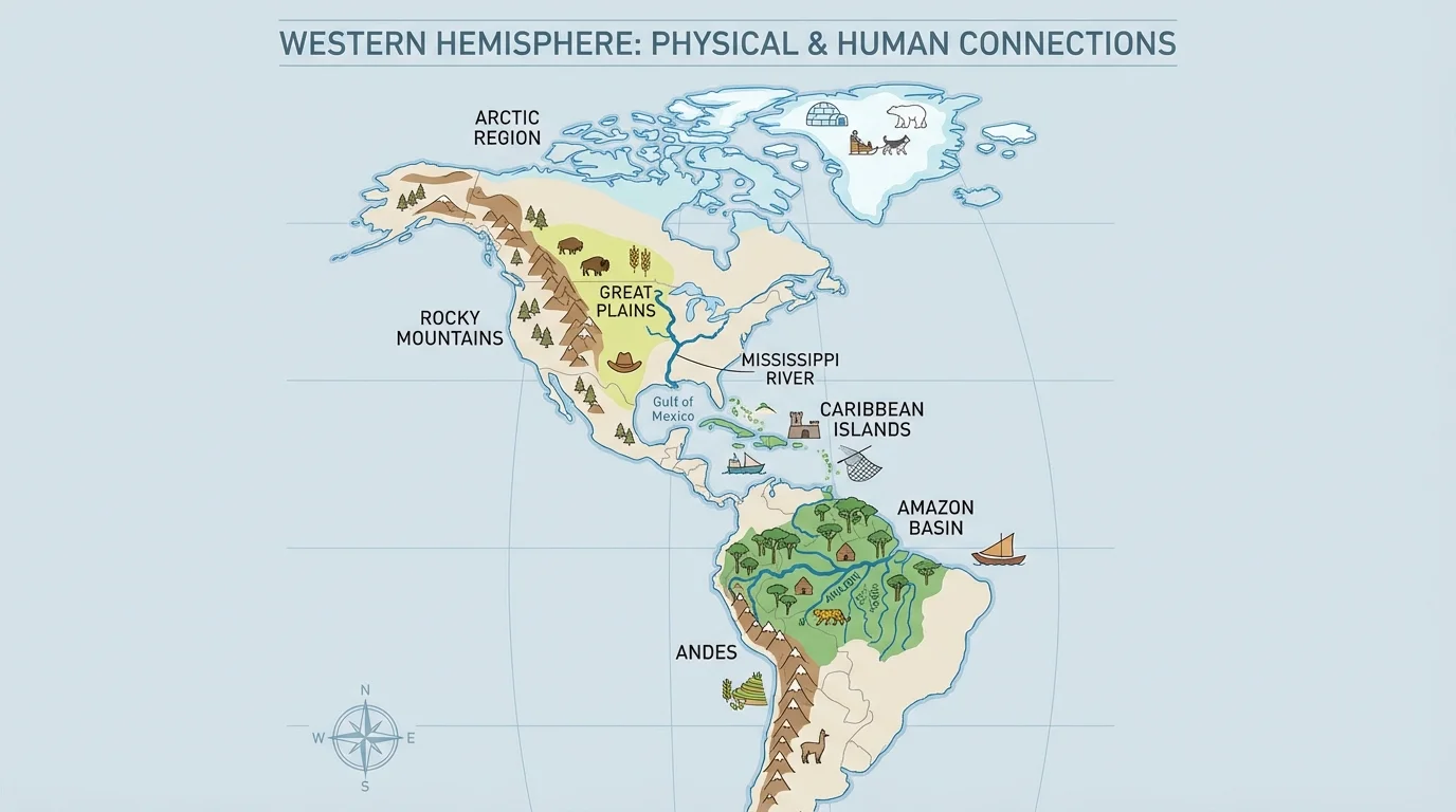
Climate also varies greatly across the hemisphere. Tropical climates near the equator are warm year-round and often wet. Dry climates create deserts in places like northern Mexico, the southwestern United States, coastal Peru, and parts of Chile. Temperate climates with four seasons are common in much of the United States, southern Canada, Uruguay, and parts of Argentina. Polar and subpolar climates in northern Canada and Greenland bring extreme cold. These climate patterns influence agriculture, clothing, transportation, and housing.
Natural resources are another major physical characteristic. Forests, fertile soil, freshwater, minerals, oil, fish, and farmland all support human activities. Countries and regions often build part of their economies around the resources available to them. For example, the Amazon region provides timber and freshwater, the Great Plains produce grains and livestock, and the Caribbean depends heavily on fisheries and tourism linked to its coastal environment.
Physical geography can also create challenges. Hurricanes affect the Caribbean and Gulf Coast. Earthquakes and volcanoes are common along parts of the Pacific coast, especially near tectonic plate boundaries. Droughts can harm farming in dry regions. Flooding can threaten river valleys and cities. These hazards influence building styles, emergency planning, and even migration patterns.
People shape places just as places shape people. Human characteristics include population density, urban growth, language, religion, government, transportation systems, and economic activities. A farming village in Guatemala, a business district in São Paulo, and a mining town in Chile each have different human characteristics because they have developed in different ways over time.
Language is one of the clearest human characteristics in the Western Hemisphere. English is widely spoken in the United States and much of Canada. Spanish is the dominant language in most of Latin America. Portuguese is the main language of Brazil. French is important in parts of Canada and Haiti. Many Indigenous languages, such as Quechua, Aymara, Navajo, Maya languages, and Guaraní, continue to shape identity and culture. Language reflects migration, colonization, resistance, and cultural survival.
Religion and belief systems also help shape places. Christianity has had a major influence across the hemisphere, especially through Roman Catholic and Protestant traditions. At the same time, Indigenous spiritual traditions remain important in many communities, and in some places religious practices blend influences from Africa, Europe, and Indigenous cultures. This blending, often called cultural syncretism, helps explain traditions in countries such as Brazil, Cuba, and Mexico.
Settlement patterns vary by geography. Large cities often grow along coasts, rivers, and transportation routes because those locations support trade and communication. Examples include New York City, Buenos Aires, Lima, Havana, and Vancouver. Rural communities often grow where farming, ranching, fishing, or mining are possible. In mountainous or rainforest regions, settlements may be smaller or more isolated because travel is harder.
Some of the largest cities in the Western Hemisphere, including Mexico City and Bogotá, are located at high elevations. Their locations show that mountains can be barriers, but they can also become centers of culture, trade, and political power.
Economic activity is another human characteristic tied closely to geography. Coastal areas may focus on ports, fishing, shipbuilding, and tourism. Fertile plains often support agriculture. Mountain regions may support mining or terrace farming. Urban areas may become centers for finance, manufacturing, media, and technology. These activities affect people's routines and often become part of regional identity.
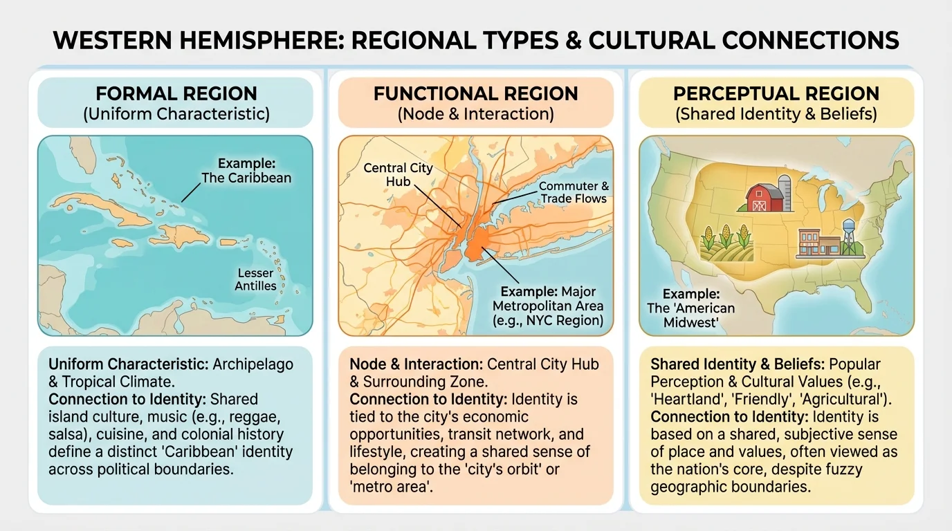
A region is an area with one or more features that make it different from surrounding areas. Geographers often divide the Western Hemisphere into regions to make it easier to study patterns. Regions are not just lines on a map. They are ways of organizing information about the world.
[Figure 2] There are three common types of regions. A formal region has official or clearly shared features, such as a country, a climate zone, or the Caribbean. A functional region is organized around a central point or activity, such as a trade network, a metropolitan area, or a river system that connects places through transportation. A perceptual region exists because people think of an area in a certain way, such as the American Midwest or the "Far North."
Regional labels can be useful, but they can also oversimplify. Latin America, for example, is often grouped together because Spanish and Portuguese are widely spoken there. Yet the region includes enormous differences in climate, economy, ethnicity, and history. The Caribbean also includes many islands with shared colonial histories and strong maritime cultures, but each island has its own language patterns, political systems, and traditions.
Studying regions helps students compare places. For example, both the Great Plains and the Pampas of Argentina are grassland regions important for farming and ranching. Both the Andes and the Rockies are mountain regions that affect travel, climate, and settlement. These comparisons show how regional differences create different opportunities and challenges.
| Region | Important Physical Traits | Important Human Traits | Examples of Cultural Connection |
|---|---|---|---|
| Andes | High mountains, cool temperatures, steep slopes | Terrace farming, Indigenous languages, mining towns | Mountain festivals, woven clothing, potato farming |
| Caribbean | Islands, warm climate, coasts, hurricane risk | Fishing, tourism, port cities, mixed cultural heritage | Seafood diets, music and dance traditions, strong seafaring identity |
| Amazon Basin | Rainforest, rivers, tropical climate | River transport, Indigenous communities, resource extraction | Forest knowledge, river-based trade, rainforest foods and medicines |
| Great Plains | Grasslands, flat land, fertile soil | Mechanized farming, ranching, small towns | Agricultural fairs, cattle culture, grain production |
| Arctic | Tundra, ice, long winters | Small settlements, hunting, fishing, adaptation to cold | Seasonal travel patterns, cold-weather clothing, deep knowledge of ice and animals |
Table 1. Examples of how physical and human characteristics connect to culture in selected Western Hemisphere regions.
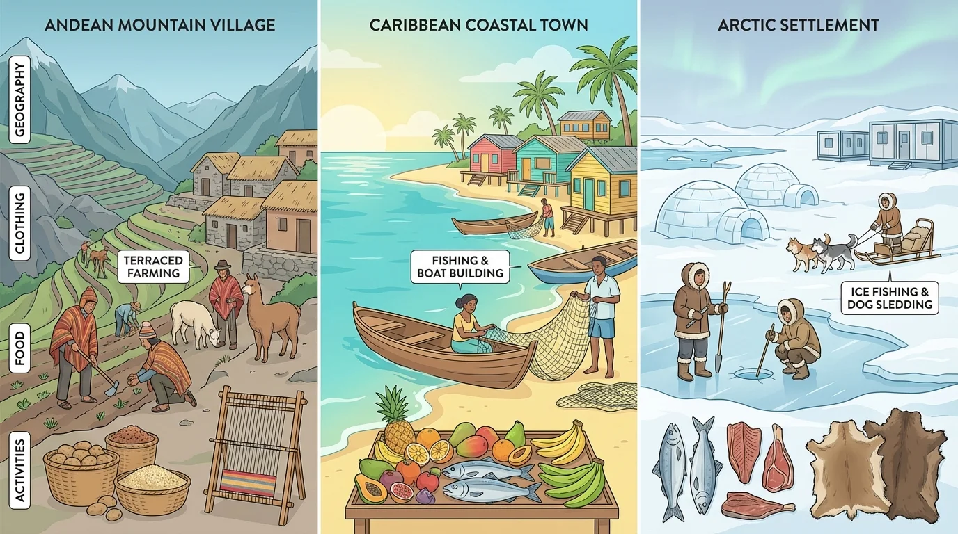
[Figure 3] The environment influences daily life in ways people may barely notice at first. Food, homes, work, celebrations, and transportation often reflect local geography. Over time, these practical choices become cultural traditions and symbols of identity.
In mountain regions such as the Andes, steep slopes lead to terrace farming, and cool temperatures affect clothing and housing. Potatoes, maize, and llamas have been important to Andean life for centuries. In tropical coastal regions, diets may include fish, tropical fruits, rice, and plantains. In cold Arctic regions, homes, clothing, and travel are designed to protect people from extreme temperatures. Geography does not completely determine culture, but it strongly influences the choices people make.
Identity can also be tied to landscapes that hold historical or spiritual meaning. Many Indigenous peoples in the Americas have strong relationships with specific rivers, forests, mountains, or plains. These places are not just resources. They are part of history, ancestry, and belief. For some communities, losing access to land means losing part of cultural identity as well.
Migration adds another layer. People moving from one region to another often bring foods, music, language, and traditions with them. Over time, cities become places where many identities mix. Miami, Toronto, and Los Angeles, for example, reflect migration from across the hemisphere. In such cities, geography still matters: ports, climate, trade routes, and job opportunities helped these cities grow and attract migrants.
Culture is shaped by both environment and history. A mountain community and a coastal community may develop different foods, jobs, and building styles because of geography, but colonization, migration, trade, and government policies also shape culture. Geographers study both natural and human influences together.
Even sports and celebrations reflect geography. Coastal communities may center festivals around fishing seasons or harbors. Agricultural regions often celebrate harvests. Winter sports are more common where snow and ice are available. Music, dance, and clothing may use materials that are locally available, from wool in highlands to plant fibers in tropical environments.
[Figure 4] Geographers often describe human-environment interactions in three ways: people depend on the environment, adapt to it, and modify it. This pattern can be seen clearly across the Western Hemisphere, where different environments require different strategies.
People depend on the environment for water, food, energy, and building materials. Communities near rivers may rely on freshwater and transportation. Farmers depend on soil and climate. Fishers depend on healthy coastal waters. Ski towns depend on snowy mountain conditions. When the environment changes, the people who depend on it must adjust.
People adapt by changing their behavior or technology to fit local conditions. In the Andes, farmers have long used terraces to farm steep mountainsides. In dry regions, irrigation helps bring water to crops. In hurricane-prone areas, buildings may be designed to resist strong winds. In Arctic regions, clothing, homes, and travel methods are adapted to cold, snow, and seasonal darkness.
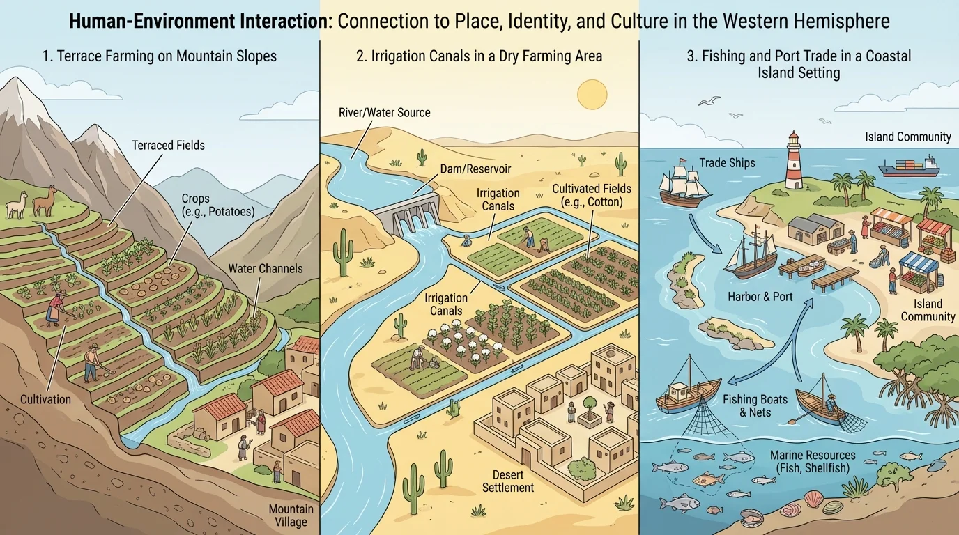
People also modify the environment. They build roads, dams, ports, canals, tunnels, and cities. They cut forests, drain wetlands, and expand farmland. These changes can bring benefits, such as transportation and food production, but they can also create environmental problems, including pollution, erosion, habitat loss, and water shortages.
The same place can be viewed very differently by different groups. A rainforest might be seen by one group as sacred land, by another as farmland, and by another as a source of timber or minerals. A river may be valuable for hydroelectric power, but a dam may flood land used by Indigenous communities. These different perspectives are part of regional geography because they influence decisions about land use and conservation.
The Andes Mountains offer a strong example of geography shaping identity. High elevation affects temperature, farming, and transportation. Many communities have preserved Indigenous traditions, including Quechua and Aymara languages, weaving styles, and agricultural knowledge. The mountain landscape has encouraged terrace farming and close community cooperation. As seen earlier in [Figure 3], life in mountain regions often leads to distinctive housing, clothing, and work patterns.
The Amazon Basin shows a different relationship between people and place. Rivers serve as transportation routes because roads are limited in many areas. Indigenous groups have deep environmental knowledge of plants, animals, and seasonal changes. At the same time, logging, ranching, mining, and road building have brought major environmental change. This creates tension between economic development and the protection of both biodiversity and cultural identity.
The Caribbean region highlights the importance of islands and coastal geography. Many Caribbean societies have cultures shaped by African, European, Indigenous, and Asian influences. Trade, colonization, slavery, and migration all left marks on language, religion, music, and food. Warm climate and beautiful coastlines support tourism, but hurricane risk and rising sea levels also affect daily life and long-term planning.
Case study: The U.S.-Mexico borderlands
This region shows how a boundary can separate countries while also connecting people through trade, migration, and shared culture.
Step 1: Identify the physical setting
The border crosses deserts, rivers, mountains, and cities. Dry climates and limited water shape settlement and farming.
Step 2: Identify the human characteristics
Spanish and English are widely used. Trade routes, factories, cities, and migration networks connect communities on both sides.
Step 3: Connect geography to identity
Many people in the borderlands develop a blended cultural identity influenced by both Mexico and the United States. Food, music, language, and family ties reflect this regional connection.
Arctic communities in Alaska, northern Canada, and Greenland provide another important example. Cold climate, ice, and seasonal change shape transportation, hunting, clothing, and housing. Indigenous groups such as the Inuit have built ways of life based on deep environmental knowledge. Today, climate change is altering sea ice and animal migration, which affects both survival and cultural traditions.
Regions are not made up of one single viewpoint. Farmers, tourists, Indigenous communities, business owners, migrants, and government leaders may all understand the same region differently. A mountain valley may be a home, a tourist destination, a mining opportunity, and a sacred landscape at the same time.
This is why perspective matters in geography. If leaders plan to build a road through a forest, they might focus on jobs and transportation. Indigenous communities may focus on protecting ancestral land. Environmental groups may focus on ecosystems and species. These views can conflict, but understanding them helps people make more informed decisions.
The comparison of region types in [Figure 2] also reminds us that regions can be defined in different ways depending on purpose. A government may define a formal region for law and administration, while local people may think of the area as a cultural homeland with different boundaries. Both views matter.
"Geography is the study of places and the relationships between people and their environments."
— Common geographic principle
Perspective also shapes environmental decisions. In the Amazon, some groups support road construction to connect markets and create jobs, while others oppose it because it can accelerate deforestation. In coastal tourist regions, hotel development may bring money but also damage coral reefs or reduce local access to beaches. Regional geography is not just about where things are. It is also about whose needs and values guide decisions.
Regional differences across the Western Hemisphere affect global trade, migration, environmental policy, and daily life. Crops grown in one climate region are shipped to another. Energy resources in one country influence manufacturing in another. Storms, droughts, and wildfires can push people to move or change jobs. Geography helps explain why some regions grow quickly while others struggle with isolation or environmental risk.
Urbanization has changed many regions. More people now live in cities, where human characteristics such as transportation systems, housing, and industry become especially important. Yet urban life still reflects physical geography. Cities on coasts face sea-level rise. Cities in earthquake zones need strong building design. Cities in dry regions must manage water carefully.
Climate change is making the connection between geography and identity even more visible. Melting Arctic ice affects Indigenous hunting traditions. Stronger storms threaten Caribbean communities. Drought can reshape farming regions. As we saw with the patterns in [Figure 1], physical geography already varies greatly across the hemisphere, and environmental change can increase those differences.
Understanding the Western Hemisphere means understanding both difference and connection. Physical and human characteristics vary from region to region, but migration, trade, technology, and history link those regions together. The result is a hemisphere full of distinct cultures and identities, each shaped in part by the places people call home.