A river can help crops grow on farms, power homes, and provide drinking water at the same time. But that same river can also flood towns, dry up downstream, or change animal habitats if people build a dam. Geography helps us understand choices like these. As [Figure 1] suggests, geographers use maps, data, and images together to study how land, water, climate, plants, animals, and people are connected across the Western Hemisphere.
Geography is the study of Earth's surface and how people interact with it. Geographers ask questions such as: Where is this place? What is it like? How is it changing? Why does it matter? To answer those questions, they investigate both physical features, such as mountains, rivers, climate, and forests, and human features, such as cities, farms, roads, languages, and trade.
In geography, a place is a specific location with its own characteristics. A region is an area that shares common features. For example, the Amazon Basin is a region because it has a tropical rainforest climate, dense forests, and a huge river system. The Great Plains are another region because they are known for wide grasslands and farming.
The Western Hemisphere includes North America, Central America, the Caribbean, and South America. It contains deserts, rainforests, mountain chains, coastal plains, and major river systems. Because this hemisphere is so varied, geographers need tools to compare places, find patterns, and solve problems.
Place is a specific location on Earth with physical and human characteristics.
Region is an area that shares common features such as climate, landforms, culture, or economy.
Geographic problem is an issue related to land, water, resources, climate, or human use of space that can be investigated with geographic tools.
Some geographic problems are natural, such as drought. Others are caused or increased by human activity, such as deforestation. Many involve interactions between environmental processes and human activity.
Geographers use a geographic tool or source depending on the question they want to answer. Often, they combine several kinds of evidence to understand one place. One tool might show where mountains are, while another shows rainfall, and another reveals where people built roads or farms.
A physical map shows landforms such as mountains, rivers, deserts, and plains. A political map shows countries, states, capitals, and borders. A climate map displays long-term weather patterns, such as temperature and rainfall. A resource map may show forests, minerals, or farmland. Each map highlights different information.
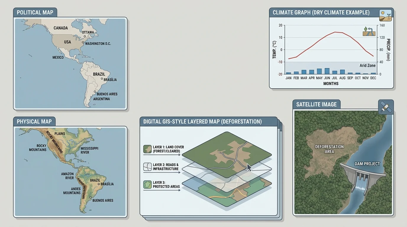
Another important source is the satellite image. Satellites take pictures of Earth from space. These images help geographers see forests, rivers, cities, coastlines, and changes over time. For example, if a forest becomes smaller over several years, satellite images can reveal exactly where the change happened.
Geographers also use graphs and tables. A climate graph can show average rainfall and temperature for each month. If a city receives very little rain for much of the year, geographers can infer that farming there may require irrigation. Data tables help compare places more carefully.
GIS, or Geographic Information System, is a digital tool that layers information on a map. One layer may show rivers, another roads, another population, and another rainfall. By stacking layers, geographers can notice patterns that are hard to see on a single map. Later, when we look at dry farming and deforestation, the kind of layered information shown in [Figure 1] becomes especially useful.
Why geographers use more than one source
One map rarely tells the whole story. A physical map may show a river, but not whether the river has enough water year-round. A climate graph may show dry months, but not where farms are located. A satellite image may show forest loss, but not political boundaries. Geographers compare sources so their conclusions are stronger and more accurate.
This is similar to solving a mystery. As [Figure 2] shows, one clue helps, but several clues together make the answer much clearer.
To solve geographic problems, geographers first need to know exactly where a place is. Coordinates help them locate places with precision through lines of latitude and longitude across the Western Hemisphere. Without accurate location, it is difficult to compare climates, track change, or plan solutions.
Latitude measures how far north or south a place is from the Equator. Longitude measures how far east or west a place is from the Prime Meridian. Together, these lines form a grid on Earth. A location written with latitude and longitude is called its absolute location.
Geographers also use relative location, which describes where a place is compared with other places. For example, Mexico is south of the United States, and the Caribbean is east of Central America. Relative location is useful when explaining movement, trade, or nearby resources.
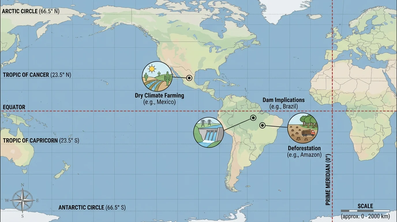
Exact location matters because climate and landforms often change with distance. Places closer to the Equator are generally warmer. Places high in the Andes Mountains may be much cooler than lowland areas nearby. If geographers know both location and elevation, they can make better predictions about farming, water supply, and settlement.
For example, a dry area near a major river may still support farming if water can be brought to fields. But a dry area far from rivers may have fewer farming choices. As we saw with the coordinate grid in [Figure 2], exact location helps connect a place to climate, water, and human use.
After locating a place, geographers describe it. They ask what makes it different or similar to other places. A place can be described by its landforms, climate, vegetation, population, culture, economy, and transportation. These characteristics help identify regions.
A region may be based on physical characteristics. The Rocky Mountains form a mountain region. The Amazon Basin forms a rainforest region. The Great Plains form a grassland region. A region may also be based on human characteristics, such as language, religion, farming style, or economic activity.
Some regions overlap. For example, parts of Brazil belong to a Portuguese-speaking cultural region and also to the Amazon rainforest region. This reminds us that regions are useful ways to organize information, but they are not always separated by sharp lines.
| Type of characteristic | Examples | How it helps geographers |
|---|---|---|
| Physical | Mountains, rivers, rainfall, soil, forests | Shows natural conditions and resources |
| Human | Cities, farms, roads, dams, language | Shows how people use and change places |
| Combined | Irrigated farmland, logging roads, coastal ports | Reveals interaction between people and environment |
Table 1. Types of geographic characteristics used to describe places and regions.
Describing regions is important because many geographic problems are regional. Drought may affect a wide dry zone, not just one town. Deforestation may spread across a large forest region. River changes may affect many communities from upstream to downstream.
The Amazon River carries more water than any other river on Earth. Its huge basin covers a large part of South America, which is one reason changes there matter far beyond one country.
As [Figure 3] helps illustrate, when geographers describe regions carefully, they can compare places and decide why one place is better for farming, settlement, transportation, or conservation than another.
Farming in a dry region is a geographic challenge because crops need water. To study this problem, geographers combine climate maps, river maps, land-use maps, and population data for dry regions in northern Mexico and the U.S. Southwest. These areas have low rainfall, hot temperatures in many months, and frequent drought risk.
If a climate graph shows very low rainfall during much of the year, geographers infer that farmers cannot depend only on rain. They may need irrigation, which is the movement of water to fields through canals, pipes, or sprinklers. River maps then help show whether enough water is nearby.
Dry-climate farming also depends on soil, elevation, and temperature. Some crops need more water than others. Cotton, vegetables, and fruit may require careful water management. Ranching may be more common than crop farming in the driest places because grasslands can support animals better than water-hungry crops.
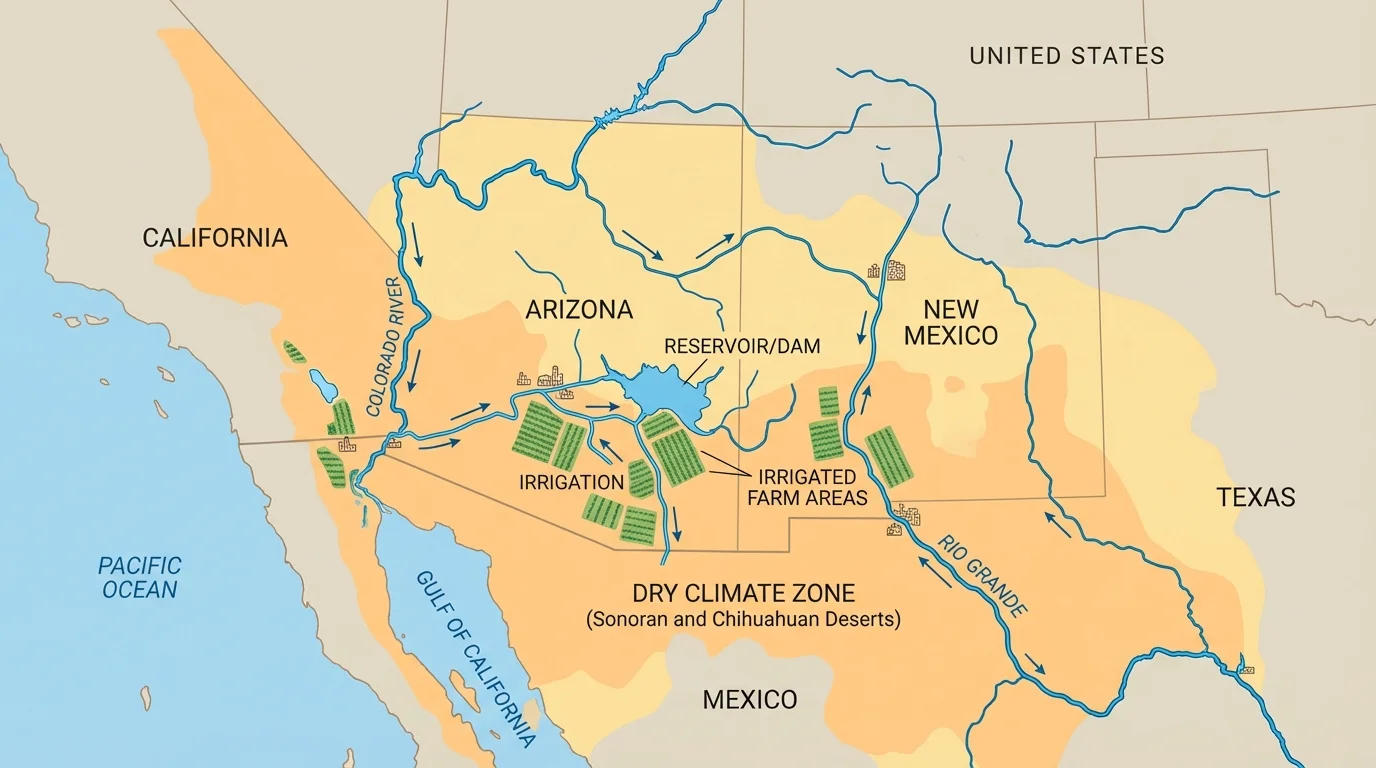
As [Figure 4] helps show in another water-management context, geographers can investigate a problem such as this: Should farmers plant more crops in a dry area? A map of rivers and reservoirs may show a water source, but population data may reveal that cities also need that same water. Satellite images may show shrinking lakes or dry reservoirs. That evidence may suggest limits on farming expansion.
Case study example: deciding whether a dry valley can support more farming
Step 1: Check the climate source.
The climate data shows very low rainfall for most months, so rain-fed farming is unreliable.
Step 2: Check water sources.
A river and reservoir are present, but maps show that towns downstream also depend on the same water.
Step 3: Check land use and satellite images.
Images show that existing fields already use much of the irrigated land, and some nearby land is dry scrubland.
Step 4: Make an inference.
The valley may support limited farming, but major expansion could increase water shortages.
This is geographic problem solving: using evidence from several tools to make a careful decision.
As the patterns in [Figure 3] make clear, access to water often matters more than empty land. A place may look open and sunny, but without enough water, large-scale farming can be difficult or unsustainable.
As [Figure 4] helps illustrate, a dam can seem like a simple wall across a river, but geographically it affects an entire river system with changes upstream and downstream. Dams are built to store water, control floods, provide irrigation, and generate hydroelectric power. They can help cities and farms, but they can also create new problems.
Upstream from a dam, a reservoir forms. This stored water can help during dry periods. Downstream, however, the river may carry less water. That can affect farms, fish, wetlands, and communities that depend on natural river flow. So geographers study not just the dam site, but the entire region connected to the river.
In the Western Hemisphere, one well-known example is the Hoover Dam on the Colorado River. It helps supply water and electricity to parts of the southwestern United States. But the Colorado River also supports farms, cities, and ecosystems in several states and in Mexico. Because so many users depend on the same river, geographic tools are essential for planning.
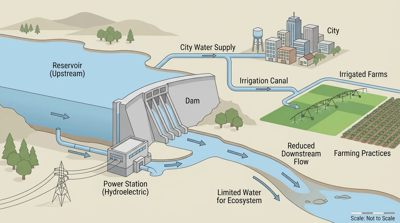
To investigate the implications of building a dam, geographers examine elevation maps, river-flow data, settlement maps, and environmental information. An elevation map can show whether the valley is suitable for a reservoir. Population maps show which communities may benefit or need to move. Environmental data can reveal how fish habitats or wetlands might change.
Trade-offs in geography
A trade-off happens when one choice brings both benefits and costs. A dam may reduce flooding and provide energy, but it may also flood land behind the dam and reduce water flow below it. Geographers study trade-offs so leaders can make better decisions.
Years after a dam is built, geographers may still use satellite images and data to measure change. As [Figure 5] also suggests about long-term landscape change, geographers often return to the same region over time to see how one decision can reshape it for years.
Forests can disappear little by little, and from the ground that change may be hard to notice. From space, however, the pattern becomes clear. Satellite images reveal where trees have been removed and how deforestation often spreads along roads, rivers, and settlement areas in the Amazon Basin.
Deforestation is the clearing of forests, often for farming, ranching, mining, roads, or settlements. In the Amazon rainforest, deforestation changes habitats, affects Indigenous communities, and can influence climate because forests help store carbon and release water vapor into the air.
Geographers investigate deforestation by comparing satellite images from different years. If one image shows dense forest and a later image shows open land, they can identify where change occurred. Maps of roads and settlements help explain why the pattern spread in those places.
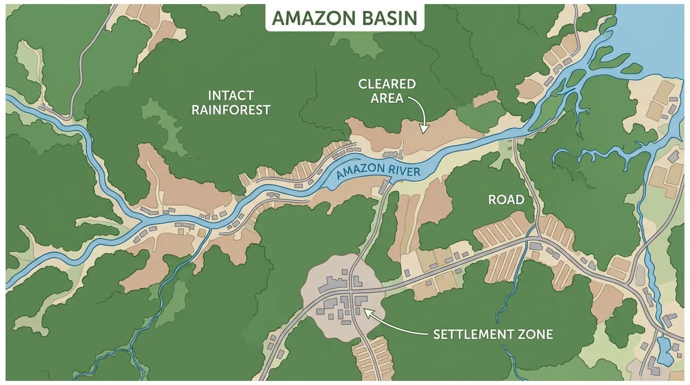
Deforestation is not only about trees. It can lead to soil erosion, less biodiversity, and changes in local rainfall. When forest cover shrinks, land may heat up faster, streams may change, and animals may lose habitat. This is why geographers connect environmental changes with human activities.
Case study example: investigating rainforest loss
Step 1: Compare images from two different years.
The earlier image shows mostly continuous forest. The later image shows cleared patches.
Step 2: Add transportation information.
Road maps show that many cleared areas are close to roads, making logging and settlement easier.
Step 3: Add human activity data.
Land-use maps show ranching and farming in some cleared zones.
Step 4: Make an inference.
The pattern suggests that transportation access and land use are major causes of deforestation.
By combining sources, geographers can explain not just where forests are disappearing, but why.
Later, when leaders discuss conservation, the same evidence from [Figure 5] helps identify areas most at risk and areas where protection may be most effective.
A geographic inference is a conclusion based on evidence from maps, images, graphs, and data. Geographers do not just collect facts; they interpret them. If a region has low rainfall, growing population, and shrinking reservoirs, geographers may infer future water stress. If roads cut deeper into a rainforest, they may predict more deforestation.
Predictions are not guesses without evidence. They are informed ideas based on patterns. For example, if irrigation expands in a dry climate faster than water can be replaced, water shortages may become more severe. If a dam reduces floods in one area, settlement may increase there because people feel safer building homes and businesses.
Good inferences depend on strong evidence. That is why geographers compare multiple sources. A single image can be helpful, but a series of images over time is stronger. A single map can describe space, but a map combined with climate and population data explains more fully what is happening.
When geographers solve problems, they often ask the same set of questions. Where is the place located? What are its physical features? What human activities are happening there? How is it changing over time? What patterns appear when different sources are compared?
This method helps avoid simple answers to complex problems. Building a dam is not only an engineering issue; it is also about regions, resources, wildlife, farming, and communities. Farming in a dry climate is not only about soil; it is also about rainfall, rivers, technology, and population. Deforestation is not only about cutting trees; it is also about roads, economics, land use, and environmental change.
You already know that maps are not all the same. Some show boundaries, some show landforms, and some show climate. This lesson builds on that idea by showing how geographers combine those sources to answer deeper questions.
The Western Hemisphere provides many examples because it includes both rich natural resources and major environmental challenges. From the deserts of northern Mexico to the rivers of the American West to the forests of South America, geography helps people understand how places work and how decisions shape regions.