Have you ever looked for the playground, the library, or a friend's classroom and wished you had a secret guide? A map is that guide. Maps help people find places, plan trips, and understand where things are. Even young geographers use maps to learn about their school, their neighborhood, and the world around them.
When we read a map, we do more than look at a picture. We use special tools to understand it. These tools include a map key, a legend, symbols, directions, and a compass rose. With these tools, we can locate places and describe where they are.
A map is a representation of a place seen from above. It is much smaller than the real place, but it helps us see where things are. A map might show a classroom, a park, a town, a state, or even the whole Earth.
Maps show spaces and places. A space is an area, like a field or a playground. A place is a special spot, like a school, a pond, or a fire station. Maps help us notice where spaces and places are and how they are arranged.
You already know some location words such as left, right, near, and far. Maps use those ideas, but they also use special direction words to be more exact.
Geography is the study of places and where things are. When we use maps, we are thinking like geographers. We look for patterns too. For example, a town map may show many homes close together and a park near a school.
A map key, also called a legend, helps us understand the marks on a map. It explains what each symbol means, as shown in [Figure 1]. A symbol is a small picture, shape, or color that stands for something real.
On a map, a tiny tree symbol might mean a park. A blue line might mean a river. A small book symbol might mean a library. Since real buildings and rivers are too large to fit on a map, symbols help show them in a simple way.
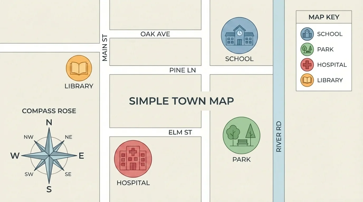
Some maps use colors in the legend too. Green may show grass or parks. Blue may show water. Black lines may show roads. When we check the key or legend first, the whole map makes more sense.
Map key or legend: explains what symbols, lines, and colors mean on a map.
Symbol: a small picture, mark, or color that stands for something on a map.
Landmark: an easy-to-see place used to help describe where something is.
A landmark can help us describe location. If the school is next to the park, the park is a landmark. If the pond is south of the playground, the playground is a landmark too. Good map readers use landmarks with symbols and legends to describe places clearly.
Maps also use direction words. The four main directions are north, south, east, and west. These are called cardinal directions. They help us say exactly where one place is compared to another.
On many maps, north is at the top, south is at the bottom, east is to the right, and west is to the left. If the library is above the school on a map, it may be north of the school. If the pond is to the left of the garden, it may be west of the garden.
Cardinal directions are more exact than saying "over there." Instead of saying "The cafeteria is that way," we can say, "The cafeteria is east of the office." That gives clearer information.
How directions help
Direction words help people share the same understanding of location. If two students look at the same map and use north, south, east, and west, they can both find the same place more easily.
We use these directions in real life too. The sun rises in the east and sets in the west. If you know that, you can connect maps to the world outside.
[Figure 2] Sometimes the main directions are not enough. A place may be between north and east or between south and west. These in-between directions are called intermediate directions.
The four intermediate directions are northeast, northwest, southeast, and southwest. Northeast is between north and east. Northwest is between north and west. Southeast is between south and east. Southwest is between south and west.
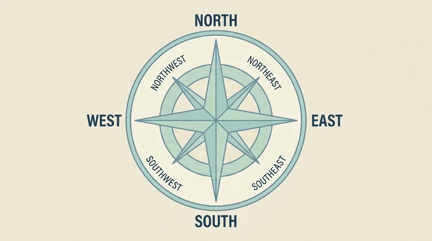
If the zoo is up and to the right of the lake on a map, the zoo is northeast of the lake. If the garden is down and to the left of the school, the garden is southwest of the school.
These words help us describe location even better. They are especially useful on maps with many places. Instead of only saying "near," we can say "northwest of" or "southeast of."
Some maps and globes use even more exact directions than the eight common ones. Pilots and sailors often need very exact directions to travel safely.
When you use intermediate directions, you are giving a more careful description. That is an important geography skill.
A compass rose is a drawing on a map that shows directions. It usually has arrows or points labeled north, south, east, and west. Many compass roses also include northeast, northwest, southeast, and southwest.
The compass rose helps us know how the map is oriented. We can look at it first and then decide how to describe a place. If the compass rose shows north at the top, we know where all the other directions are too.
Some compass roses are simple. Others are more detailed and colorful. No matter how they look, they all do the same job: they help us use directions correctly.
When students confuse left and right on a map, the compass rose can help. Instead of guessing, they can use the rose to check direction words before answering.
[Figure 3] Skilled map readers use all the tools together. They look at the key or legend to understand symbols, then use the compass rose and direction words to locate places and describe them clearly.
Think about a map of a school. A square symbol may mean the office. A swing-set symbol may mean the playground. A leaf symbol may mean the garden. The compass rose tells us which way is north.
Now we can describe locations. If the garden is to the right and a little above the office, it may be northeast of the office. If the cafeteria is below the office, it is south of the office. If the playground is left of the garden, it may be west of the garden.
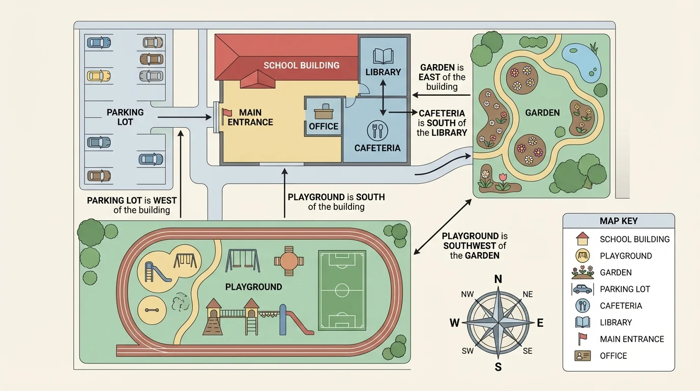
Using a school map
Step 1: Look at the legend.
The star means office, the ball means playground, and the leaf means garden.
Step 2: Check the compass rose.
North is at the top, east is to the right, south is at the bottom, and west is to the left.
Step 3: Describe one place from another.
If the playground is left of the office, the playground is west of the office.
Step 4: Use an intermediate direction if needed.
If the garden is above and right of the office, the garden is northeast of the office.
This is how geographers and travelers use maps. They do not rely on only one clue. They use symbols, legends, landmarks, and directions together.
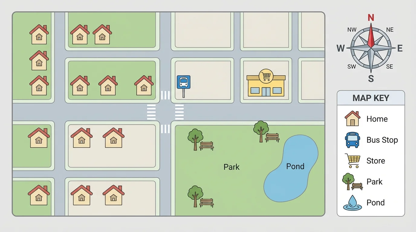
[Figure 4] A neighborhood map can show streets, houses, stores, a bus stop, and a park. Students can use direction words to describe these places.
For example, the park may be north of the grocery store. The pond may be east of the park. The bus stop may be southwest of the school. These descriptions help someone find each place.
A park map might use symbols for picnic areas, restrooms, trails, and water fountains. The legend explains the symbols. The compass rose helps visitors know which trail goes east or west. A family can use the map to find the playground or the lake.
A town map may show a hospital, fire station, library, and post office. On such a map, the hospital may be southeast of the library. The fire station may be west of the park. As we saw with the earlier school map in [Figure 3], combining the legend with direction words makes the map much easier to read.
Different places can use different symbols, but every good map gives clues to help the reader understand it.
| Map type | What it may show | Helpful tools |
|---|---|---|
| School map | Office, classrooms, playground, cafeteria | Legend, compass rose, landmarks |
| Park map | Trails, lake, picnic area, restrooms | Symbols, legend, directions |
| Neighborhood map | Homes, streets, store, bus stop, park | Compass rose, symbols, landmarks |
| Town map | Library, hospital, roads, parks | Key, legend, cardinal and intermediate directions |
Table 1. Examples of different maps, what they show, and which map tools help readers use them.
When we describe location, it helps to use complete direction phrases. We can say, "The library is north of the school." We can also say, "The pond is southwest of the playground." These sentences tell where one place is compared with another place.
Another strong way to describe location is to use landmarks. For example, "The nurse's office is east of the main office" or "The garden is near the back gate." Landmarks make directions easier to understand.
Good location descriptions are clear and exact. They use map words instead of guessing words. Saying "The trail starts west of the parking lot" is better than saying "The trail starts over there."
Three location descriptions
Example 1: If the pond is above the field, the pond is north of the field.
Example 2: If the library is below and left of the school, the library is southwest of the school.
Example 3: If the bus stop is right of the park, the bus stop is east of the park.
These map-reading sentences help people share information clearly. They also help us understand how places connect to one another.
Map skills are useful in daily life. People use maps to visit new places, find hiking trails, plan drives, and learn about communities. Emergency workers use maps to find streets quickly. Families use maps in parks, zoos, and museums.
These tools also help us understand patterns in the world. If many homes are west of a river and stores are east of it, a map can show that pattern. Geography is not only about finding one place. It is also about noticing how places are arranged.
Maps can tell stories about human activities and natural places. A map may show where roads, schools, and neighborhoods are built. It may also show lakes, rivers, forests, and hills. Learning to read a map helps us understand both people and nature.
When you use a legend, symbols, intermediate directions, and a compass rose, you are building a strong geography skill. You are learning how to locate places, compare them, and describe them so others can understand.