Have you ever looked at a globe and wondered how people know where a place is without pointing right at it? Earth is huge, but geographers have clever ways to describe location. They use important lines and points on the globe to help everyone talk about the same place. These lines are not painted on Earth, but they help us understand where places are.
Earth is shaped like a sphere. Because of its shape, people use special imaginary lines to divide it into parts. These parts help us describe whether a place is north, south, east, or west. They also help us talk about the very top and very bottom of Earth.
A globe is a model of Earth. It shows land, water, and the shape of the whole planet. A flat map is useful too, but a globe helps us see Earth more like it really is. On a globe, we can notice that some places are above the middle, some are below it, some are to the right, and some are to the left.
To make location easier, geographers use special names for parts of Earth. They talk about hemispheres and important lines. These names help us compare places. For example, one city may be north of the middle line, while another is south of it.
Imaginary lines are lines people use on maps and globes to help locate places. They are not really drawn on Earth, but they are very important in geography.
When we learn these lines and places, we can describe Earth more clearly. We can say that Brazil is mostly in one part of Earth, or that Antarctica is near the bottom of the globe. These are geographic ways to explain location.
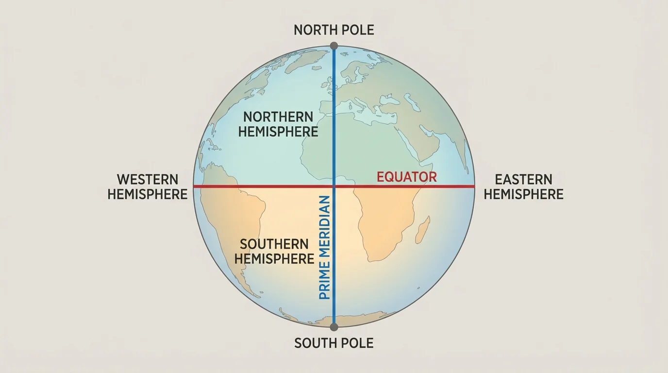
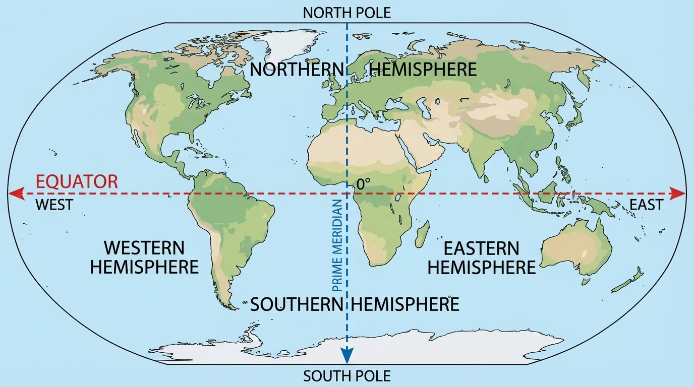
A hemisphere is one half of Earth. Earth can be divided in more than one way. When we divide Earth into northern and southern halves, we get the Northern Hemisphere and the Southern Hemisphere. When we divide Earth into eastern and western halves, we get the Eastern Hemisphere and the Western Hemisphere.
The Northern Hemisphere is the half of Earth north of the Equator. The Southern Hemisphere is the half south of the Equator. The Eastern Hemisphere is mostly east of the Prime Meridian, and the Western Hemisphere is mostly west of the Prime Meridian.
A place can be in two hemispheres at the same time. For example, the United States is in the Northern Hemisphere and the Western Hemisphere. Australia is in the Southern Hemisphere and the Eastern Hemisphere. This is one way geographers describe where places are.
Some continents are in more than one hemisphere. Africa is a great example. Part of Africa is north of the Equator and part is south of it. Part of Africa is also east of the Prime Meridian, and a small part is west of it. This means Africa is found in all four hemispheres, which we can understand more easily by looking back at [Figure 1].
Earth has four main hemispheres when we use both the Equator and the Prime Meridian. A single country or continent can even be in more than one hemisphere at once.
Knowing hemispheres helps people describe large areas of the world. Instead of naming every nearby country and ocean, we can use one clear geographic term.
The Equator is an imaginary line that goes around the middle of Earth. It divides Earth into the Northern Hemisphere and the Southern Hemisphere. If a place is above the Equator on a map or globe, it is in the Northern Hemisphere. If it is below the Equator, it is in the Southern Hemisphere.
The Equator is like a belt around the center of Earth. It is equally far from the North Pole and the South Pole. That is why it is considered the middle of Earth. Many warm places are near the Equator because they get strong sunlight during the year.
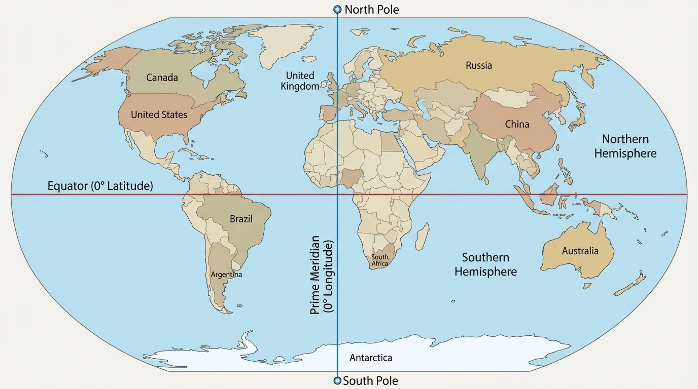
Some countries the Equator passes through are Ecuador, Brazil, Kenya, and Indonesia. These places are in different parts of the world, but they share one important feature: the Equator crosses them or passes very close by. That tells us something important about their location.
If we compare Canada and Kenya, Canada is far north of the Equator, while Kenya is close to it. If we compare Argentina and Egypt, Argentina is mostly south of the Equator, while Egypt is north of it. The Equator helps us make these comparisons clearly.
Why the Equator matters
The Equator helps people describe where places are and understand natural patterns. Places near the Equator are often warmer, while places farther north or south are usually cooler. This shows how location can affect weather and daily life.
When students look at a map, finding the Equator first is a smart idea. It quickly tells whether a place belongs to the Northern Hemisphere or the Southern Hemisphere.
The Prime Meridian is another imaginary line. It runs from the North Pole to the South Pole and divides Earth into the Eastern Hemisphere and the Western Hemisphere. Places to the east of this line are in the Eastern Hemisphere. Places to the west are in the Western Hemisphere.
The Prime Meridian passes through Greenwich in England and continues through parts of Europe, Africa, and the ocean. It helps geographers describe whether a place is east or west. It is different from the Equator because it runs from pole to pole instead of around the middle.
For example, India is in the Eastern Hemisphere because it is east of the Prime Meridian. Most of North and South America are in the Western Hemisphere because they are west of the Prime Meridian. These words help us locate places more exactly.
The city of London is close to the Prime Meridian. Japan is far to the east of it. Brazil is mostly west of it. By using this line, people can describe where places are without needing to point to them on a globe. This east-and-west idea becomes much clearer when we return to [Figure 3].
North and south tell direction up and down on a globe. East and west tell direction across the globe. The Equator helps with north and south, and the Prime Meridian helps with east and west.
When we use the Equator and Prime Meridian together, we can place a location in a pair of hemispheres. That makes geography more exact and useful.
The North Pole and the South Pole are the two farthest points on Earth from each other. The North Pole is at the very top of Earth. The South Pole is at the very bottom of Earth. These are not hemispheres. They are special points on the globe.
The North Pole is in the Arctic region, and the South Pole is on the continent of Antarctica. Both places are very cold. They are far from the Equator, and they receive sunlight differently during the year.
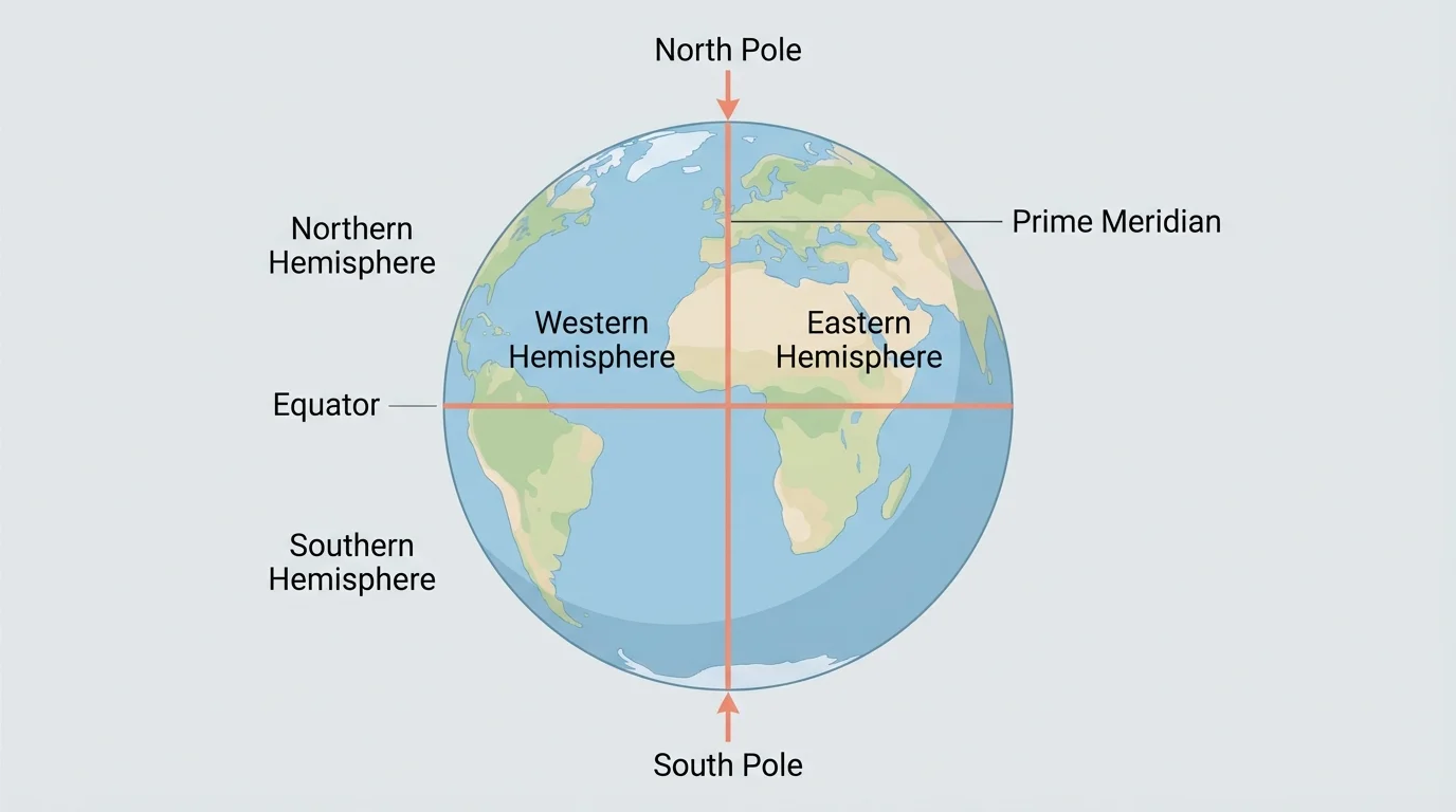
The poles help us understand the shape of Earth and the directions of north and south. If you travel north, you move toward the North Pole. If you travel south, you move toward the South Pole. Every place on Earth is somewhere between these two points, as shown in [Figure 4].
On many globes, the North Pole is at the top and the South Pole is at the bottom. That makes it easier to read directions. We can also see why the Equator is halfway between the two poles.
Location examples
Step 1: Think about Brazil.
Brazil is mostly south of the Equator and west of the Prime Meridian, so most of Brazil is in the Southern Hemisphere and the Western Hemisphere.
Step 2: Think about Canada.
Canada is north of the Equator and west of the Prime Meridian, so Canada is in the Northern Hemisphere and the Western Hemisphere.
Step 3: Think about Australia.
Australia is south of the Equator and east of the Prime Meridian, so Australia is in the Southern Hemisphere and the Eastern Hemisphere.
These examples show that the same set of geographic terms can be used for countries all around the world. That is why these terms are such helpful tools.
Geographers often use all of these ideas at once. First, they may ask whether a place is north or south of the Equator. Then they may ask whether it is east or west of the Prime Meridian. Finally, they may notice how close it is to the North Pole or the South Pole.
For example, Mexico is north of the Equator and west of the Prime Meridian. South Africa is mostly south of the Equator and east of the Prime Meridian. Greenland is in the Northern Hemisphere and is much closer to the North Pole than Kenya is. Each description gives more information about location.
| Geographic term | What it is | What it helps describe |
|---|---|---|
| Equator | Imaginary line around the middle of Earth | North or south |
| Prime Meridian | Imaginary line from pole to pole | East or west |
| Northern Hemisphere | Half of Earth north of the Equator | Places above the Equator |
| Southern Hemisphere | Half of Earth south of the Equator | Places below the Equator |
| Eastern Hemisphere | Half of Earth east of the Prime Meridian | Places to the east |
| Western Hemisphere | Half of Earth west of the Prime Meridian | Places to the west |
| North Pole | Top point on Earth | Farthest north |
| South Pole | Bottom point on Earth | Farthest south |
Table 1. Geographic terms and what each one tells us about location on Earth.
This kind of chart helps us compare the words quickly. It also shows that each term has a special job in geography.
Let's look at a few more places. Egypt is in the Northern Hemisphere and the Eastern Hemisphere. Chile is in the Southern Hemisphere and the Western Hemisphere. China is in the Northern Hemisphere and the Eastern Hemisphere. These examples show how the world can be described with the same location words.
Oceans can be described this way too. Much of the Arctic Ocean is near the North Pole. The Southern Ocean circles Antarctica near the South Pole. Parts of the Atlantic Ocean lie both north and south of the Equator. Geography words work for water as well as land.
Some airplanes and ships cross the Equator during travel. When they do, they move from one hemisphere to another.
Maps, globes, and even weather reports use these location ideas. A forecast may talk about the Southern Hemisphere, or a map may show countries in the Eastern Hemisphere. These are real tools people use every day.
Learning these terms helps us read maps better, understand globes, and talk about places more clearly. It also helps us notice spatial patterns. For example, places near the Equator often have warm climates, while places near the poles are much colder.
These words are also useful when learning about animals, people, and environments. Penguins live in the Southern Hemisphere, especially near Antarctica. Polar bears live in the Northern Hemisphere, near the Arctic. Knowing hemispheres and poles helps us understand why these animals live where they do.
When we know the Equator, Prime Meridian, hemispheres, and poles, Earth becomes easier to describe. Instead of saying a place is "over there," we can use accurate geography words. That is what geographers do: they use clear terms and tools to understand where places are and how the world is organized.