Have you ever looked at a map and noticed that a tiny blue line can mean a river and a small black line can mean a road? Maps are full of symbols and visual clues. When we learn how to read those clues, we can find parks, rivers, schools, borders, and many other places. A map is a representation of a place, and the map key or legend helps us understand what it shows.
A map shows an area as seen from above. It helps us see where things are. We can use maps to find where people live, where water flows, where roads go, and where one place ends and another begins.
Maps help us answer questions such as: Where is the school? Is the park near the river? Which road goes to the library? Is the mountain inside the state border or outside it? Good map readers use symbols, colors, and labels to find answers.
You already know that words like north, south, east, and west help describe location. These direction words are important when reading maps.
Some maps show a neighborhood. Some show a city, a state, or a whole country. No matter how big or small the map is, the same map-reading skills help us understand it.
Maps have parts that help us read them. A map often has a title, labels, a compass rose, and a legend. Each part gives us information about the place on the map.
[Figure 1] As you study the example map, notice how the title, labels, compass rose, and legend work together to explain the place shown.
The title tells what the map is about. A title might say "Our Town Park" or "Map of Florida." Labels name places, such as River Road, Pine School, or Blue Lake. A compass rose shows directions, so we know which way is north, south, east, and west.
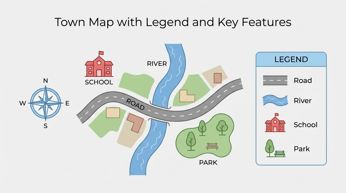
Another important part is the map key, also called a legend. The key explains what the symbols and colors mean. Without a key, a map would be much harder to understand.
A map key, or legend, is the part of a map that explains what symbols, lines, and colors stand for. A blue line might mean a river, and a green area might mean a park or forest.
When you read a map, start by looking at the title and the key. Then look at the compass rose. After that, read the labels and symbols carefully. These steps help you understand the map clearly.
Maps can show many kinds of places. On one map, we may find natural features, human features, political features, and cultural features. Learning these groups helps us talk about maps more clearly.
[Figure 2] The example map below shows how different kinds of features can appear together in one place.
Natural features are parts of Earth made by nature. These include rivers, lakes, oceans, hills, mountains, forests, deserts, and beaches. People do not build these features. For example, a blue shape on a map might show a lake, and a green area might show a forest.
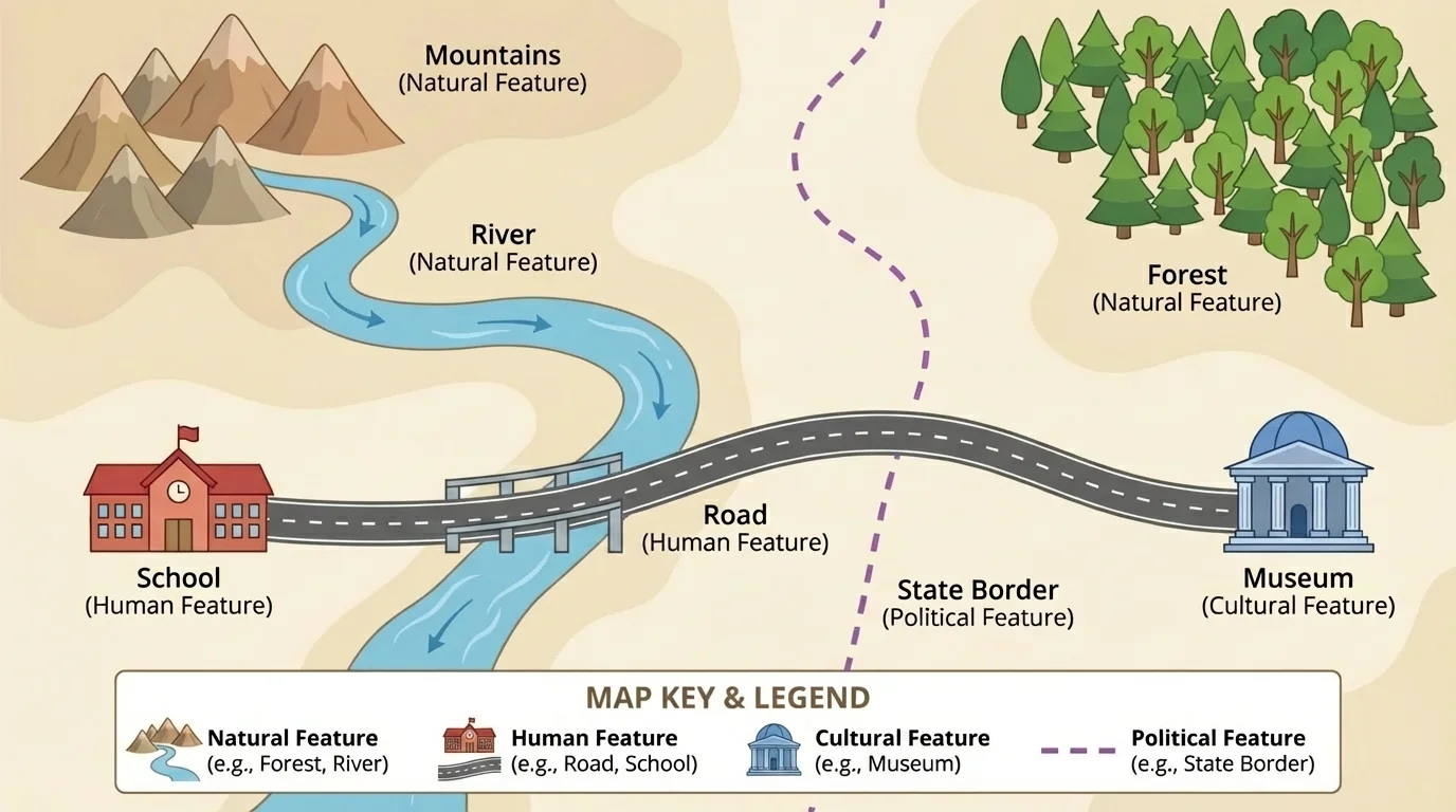
Human features are made or built by people. These include roads, bridges, schools, homes, railways, and parks. A black line might stand for a road, and a small square might stand for a building.
Political features show how places are divided for government. These include country borders, state borders, county lines, and city boundaries. A map may use dark lines or dotted lines to show where one state ends and another begins.
Cultural features are places and things that show how people live, learn, believe, celebrate, and remember. These can include museums, churches, temples, monuments, libraries, and theaters. A museum on a map is not natural, and it is not a border. It is a cultural feature because it is part of community life and history.
One place can connect to more than one idea. A city park is a human feature because people made it, but it can also include natural features like trees, grass, and a pond.
When we identify features, we ask: Was it made by nature? Was it built by people? Does it show a border? Does it help show how people live and share culture? These questions help us sort map features into the right group.
Map symbols are tiny pictures or marks that stand for real things. A legend helps us match each symbol to its meaning. A small tree symbol may mean a park. A cross symbol may mean a hospital. A book symbol may mean a library.
[Figure 3] The example below shows how a legend connects map symbols to real places on a map.
Colors also give clues. Blue often shows water. Green often shows land with plants, such as parks or forests. Black or red lines often show roads. Different maps may use different colors, so the legend is always the best place to check first.
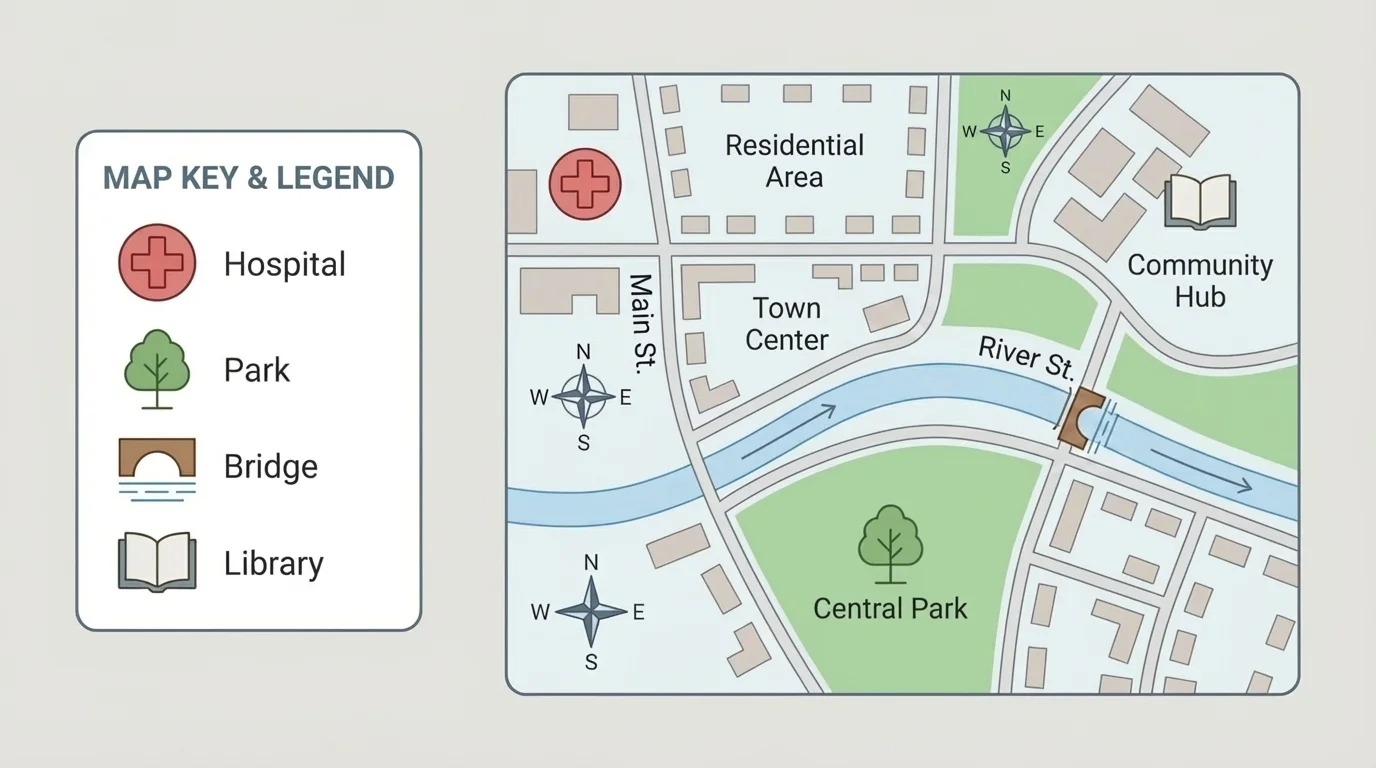
When a blue line in the legend means a river, you can find the river on the map. If you see the tree symbol near a road, you know a park is there. If you see a star, you can locate the capital city.
Reading a simple legend
A neighborhood map has these symbols in the legend: tree = park, book = library, red line = main road.
Step 1: Look at the legend first.
The legend tells what each symbol means.
Step 2: Find the symbols on the map.
Look for the tree, book, and red line symbols.
Step 3: Match the symbols to real places.
The tree shows the park, the book shows the library, and the red line shows the main road.
Using the legend turns map symbols into useful information.
Later, when you compare maps, remember what we saw in [Figure 1]: the title and compass rose help, but the legend is the part that explains the symbols most directly.
Different maps focus on different things. A park map might show trails, ponds, picnic areas, and playgrounds. A town map might show roads, schools, hospitals, and neighborhoods. A state map might show cities, rivers, and borders.
On a park map, a pond is a natural feature, while a playground is a human feature. On a town map, city hall is a human feature, and the city boundary is a political feature. On a map of a country, a monument or museum can be a cultural feature.
| Feature | Type of Feature | Possible Map Clue |
|---|---|---|
| River | Natural | Blue line |
| Mountain | Natural | Brown or mountain symbol |
| Road | Human | Black or red line |
| School | Human | Building symbol or label |
| State border | Political | Boundary line |
| Museum | Cultural | Special building symbol or label |
Table 1. Examples of map features, their types, and common clues used to locate them.
Map readers also use location words to describe where features are. A library may be north of the school. A river may be east of the town. A park may be next to a road. A mountain may be far from the city. These words help us describe a place clearly.
Maps show location and relationship
A map does more than name places. It also shows how places are related. It helps us see what is near, what is far, what is inside a boundary, and what is connected by roads or rivers.
When we locate a feature, we first identify what it is by using the key or legend. Then we describe where it is using direction words, nearby features, and boundaries.
Maps help us notice spatial patterns, which are ways features are arranged in space. Some features are grouped together, and some are spread far apart.
[Figure 4] The map below helps us see how groups of features can cluster together or spread out across an area.
For example, many houses may be close to roads. Farms may be near flat land and water. Forests may cover large areas away from busy towns. Cities are often found near rivers, coasts, or roads because these places help people travel and trade.
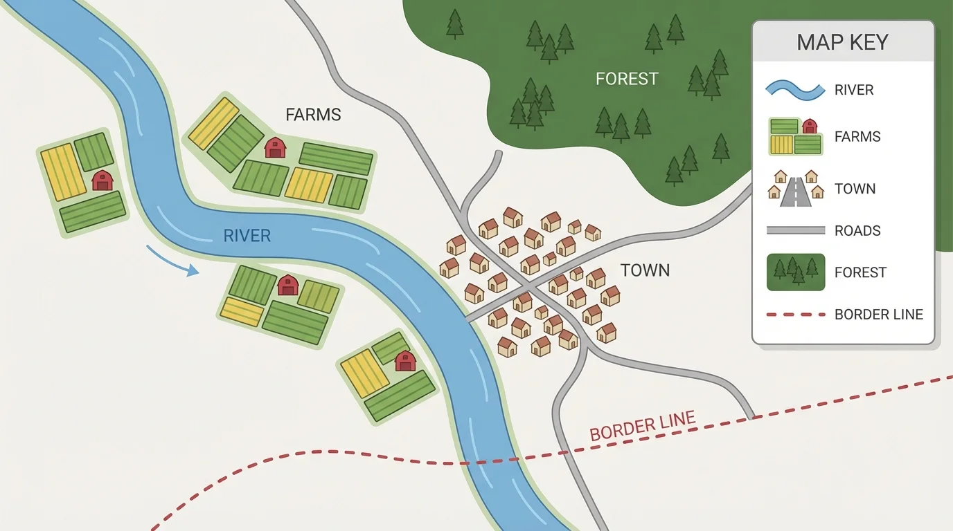
We may also notice that stores are grouped in one area while farms are spread out in another place. Parks may be spread around a town so people in different neighborhoods can reach them.
Thinking about patterns helps us understand why places are where they are. Looking back at [Figure 2], we can compare different types of features in one area and see that natural, human, political, and cultural features all share space in different ways.
Looking for a pattern on a map
A town map shows homes along two roads, a school near the homes, and farms outside the town near a river.
Step 1: Find features of the same kind.
The homes are all human features. The farms are also human features. The river is a natural feature.
Step 2: Notice where they are placed.
The homes are grouped along roads. The farms are outside town near water.
Step 3: Describe the pattern.
People live close together in town, and farms are spread out near land and water.
This is a spatial pattern because it shows how features are arranged.
Patterns help us make sense of maps instead of seeing only separate symbols.
Map-reading skills are useful in everyday life. Families use maps to travel. Hikers use trail maps in parks. Emergency workers use maps to find roads, bridges, and hospitals quickly. Community leaders use maps to decide where new schools, parks, or roads should go.
Maps also help us learn about places near and far. A map of our neighborhood helps us know our community. A map of a state helps us find cities and borders. A map of the world helps us learn about countries, oceans, and landforms.
"A map helps us see where we are and where we can go."
When you read a map carefully, you are doing the work of a geographer. You are identifying features, locating them, and describing how places are connected. That is a powerful way to understand the world.