A letter, a package, or even someone trying to find a place needs good directions. An address is like a set of location clues. It tells where a place is so people can find it. When we say an address clearly, we help others know exactly where a home, school, or building is.
Addresses are part of geography, which is the study of places and where things are. Geography helps us talk about places using words such as street, city, state, country, and map. These labels help us move from one place to another and understand where we are in the world.
People use addresses every day. A family may use an address to get mail. A bus driver may use an address to know where to go. A map can use address labels to help show the right place. When we know an address, we can tell others where something is.
An address is helpful because it gives clues in order. It starts with a small location, such as a house or building number and a street name. Then it moves to bigger places, such as the city, the state, and the country. Each part narrows the search and helps us find the correct spot.
Address means the words and numbers that tell where a place is.
Map is a drawing that shows where places are.
Label means a word on a map or sign that names a place.
When someone recites an address, that means the person says it out loud in the right order. Saying it clearly helps listeners understand each part. The order matters because each part gives more information about the place.
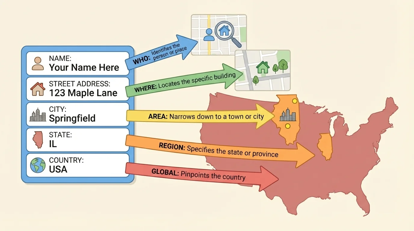
[Figure 1] shows that an address has parts that we can read one after another. One part may be the street number and street name, such as 25 Pine Street. Then come the city, the state, and the country. These parts work together to name one place.
Here is an example of a full address: 25 Pine Street, Denver, Colorado, United States. In this address, 25 Pine Street gives the exact street address. Denver tells the city. Colorado tells the state. United States tells the country.
Some addresses may look a little different in different places, but city, state, and country are still important location labels. They help us understand where a place belongs. A street can have the same name in more than one city, so the city label helps. A city name can appear in more than one state, so the state label helps too.
Example address spoken aloud
Step 1: Say the street part.
"25 Pine Street"
Step 2: Say the city.
"Denver"
Step 3: Say the state.
"Colorado"
Step 4: Say the country.
"United States"
Put together, the address is: 25 Pine Street, Denver, Colorado, United States.
When we recite an address, we usually move from the smallest place to the biggest place. That order is easy to follow. It helps a listener build a picture of where the place is.
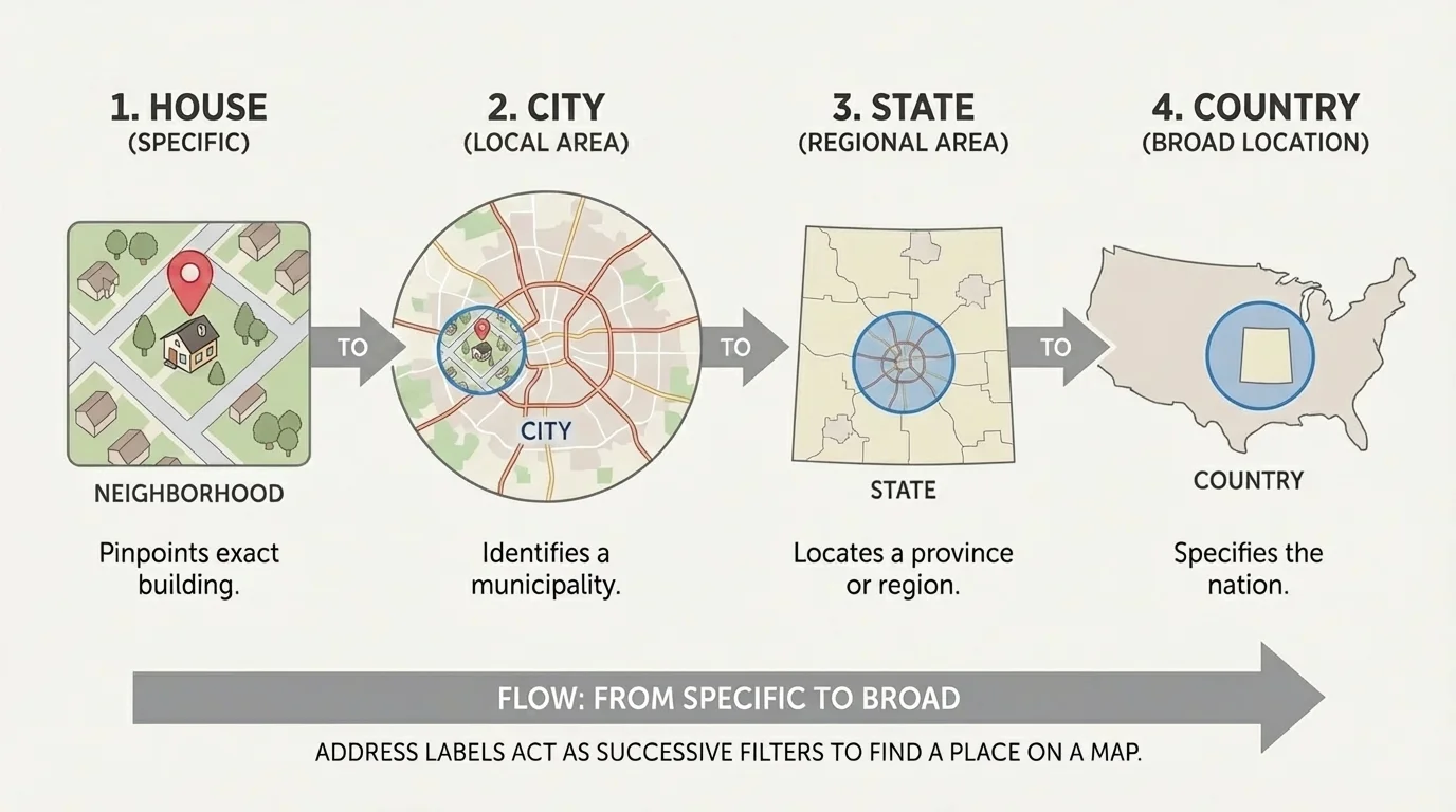
[Figure 2] illustrates how maps show small places inside bigger places. A home is on a street. That street is in a city. The city is in a state. The state is in a country. Map labels help us see these place levels.
If we look at a map of a country, we can find a state. If we look closer, we can find a city in that state. If we zoom in even more, we may find streets. This is how address labels and maps work together.
A map label is important because it names the place we are looking at. Without labels, many places on a map would be hard to tell apart. With labels, we can say, "This city is Denver," or "This country is the United States."
Small place to big place
An address works like a set of boxes. The street is inside the city, the city is inside the state, and the state is inside the country. This pattern helps people find one exact place instead of getting lost among many places with similar names.
Think about a classroom cubby inside one classroom, inside one school. Place labels on a map work in a similar way. They show where something belongs.
A city is a place where many people live, work, and go to school. Cities have streets, homes, stores, parks, and schools. A city is smaller than a state and smaller than a country.
A state is a larger part of a country. States contain many cities and towns. In the United States, examples of states are Texas, Florida, and Colorado.
A country is the biggest label in this lesson. A country can have many states or other large regions, and many cities inside them. Countries around the world include the United States, Canada, Mexico, Japan, and Kenya.
Some city names are used in more than one place. That is why adding the state and country is so helpful when we want to find the right place.
When we hear the address "25 Pine Street, Denver, Colorado, United States," each new label gives us a bigger place. We can use the same idea with many addresses. The city, state, and country help us know exactly which place we mean.
To recite an address, speak calmly and in order. First say the street number and street name. Next say the city. Then say the state. Last, say the country.
For example, a student might say, "18 Lake Road, Austin, Texas, United States." Another student might say, "7 Green Lane, Toronto, Ontario, Canada." Even though the second example uses a province instead of a state in that country, the idea is still the same: we move from a smaller place to a bigger place.
Listening for address parts
Step 1: Hear the street.
"18 Lake Road" tells the exact street location.
Step 2: Hear the city.
"Austin" tells the city.
Step 3: Hear the state.
"Texas" tells the state.
Step 4: Hear the country.
"United States" tells the country.
Each part helps narrow the search to one place.
As we saw earlier in [Figure 1], the parts of an address fit together in a clear order. That order helps both people and maps. It is easier to find a place when we know which city, which state, and which country to look in.
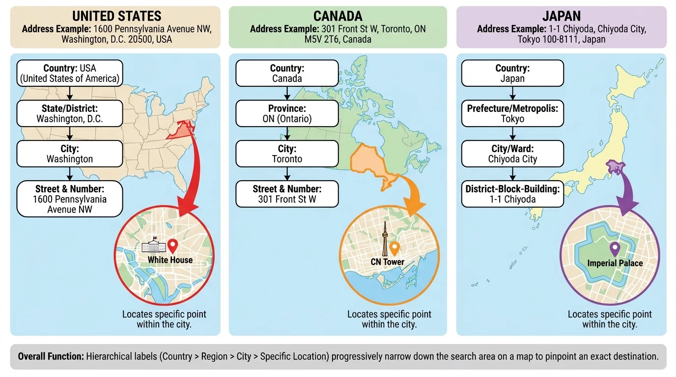
[Figure 3] shows examples from different countries where people write and say addresses in ways that can look different. But the big idea stays the same: labels help us find places. A city label names a smaller area inside a bigger area. A country label tells which nation the place belongs to.
For example, Paris is a city in France. Nairobi is a city in Kenya. Tokyo is a city in Japan. If a map shows only the city name, we may still need the country label to know which part of the world to look at.
Maps can also help us compare places. One city may be near mountains. Another may be near an ocean. One state may be hot often, while another may be snowy in winter. Geography helps us describe these places and understand where they are.
| Place label | What it tells us | Example |
|---|---|---|
| Street | The exact road or location | Pine Street |
| City | The local place with many streets and buildings | Denver |
| State | A larger part of a country with many cities | Colorado |
| Country | The biggest place name in the address | United States |
Table 1. The table shows common address labels and what each one tells us.
When we compare addresses from more than one country, we learn that people everywhere use place labels to help with location. That is a big geography idea. Labels organize space so people can understand where places are.
Your address is important information. Children should share a home address only with trusted adults, teachers when needed, or helpers in safe situations. It is smart to be careful with private information.
Still, learning how an address works is useful. It helps us understand maps, neighborhoods, cities, states, and countries. It helps us speak clearly about where places are.
When we return to the map idea in [Figure 2], we can see why labels matter so much. A map becomes more helpful when we can connect each address part to a place on the map. That is how city, state, and country help us find where something is.