A map can fit the whole world onto a flat page. That is amazing when you think about it. With maps, people can find oceans thousands of miles wide, mountains taller than clouds, giant cities full of people, and even one state like Colorado. Learning to read maps helps you understand where places are, how places connect, and what the world looks like near and far.
A map is a drawing of a place from above. Some maps show the whole world. Some show one country, one state, or even one neighborhood. A globe is a round model of Earth, but maps are often easier to carry and study.
Maps help us answer questions such as: Where is Africa? Which ocean is west of North America? What state is north of Colorado? Where are big cities? To answer these questions, we use map clues. A compass rose shows directions such as north, south, east, and west. A key, or legend, explains symbols. Labels tell the names of places. Colors often show land and water, and sometimes different heights of land.
When we learn to find places on maps, we are using spatial thinking. This means thinking about where places are and how they are arranged. For example, Colorado is west of Kansas and south of Wyoming. That is spatial thinking because it tells location and direction.
Compass rose shows directions on a map. Key explains the symbols used on a map. Scale shows how map distance matches real distance. These tools help readers understand what they are seeing.
Some maps are political maps, which show countries, states, and borders. Other maps are physical maps, which show landforms such as mountains, plains, rivers, and oceans. Good map readers know that different maps are made for different purposes.
The world is made of huge land areas and huge water areas. A continent is a very large area of land. An ocean is a very large body of salt water. On a world map, we can spot the biggest land and water areas and learn their names and locations.
[Figure 1] There are seven continents: North America, South America, Europe, Africa, Asia, Australia, and Antarctica. North America is the continent where the United States and Colorado are located. Antarctica is the icy continent around the South Pole. Asia is the largest continent.
There are five oceans: Pacific Ocean, Atlantic Ocean, Indian Ocean, Arctic Ocean, and Southern Ocean. The Pacific Ocean is the largest ocean. The Atlantic Ocean lies between the Americas and Europe and Africa. The Arctic Ocean is near the North Pole.
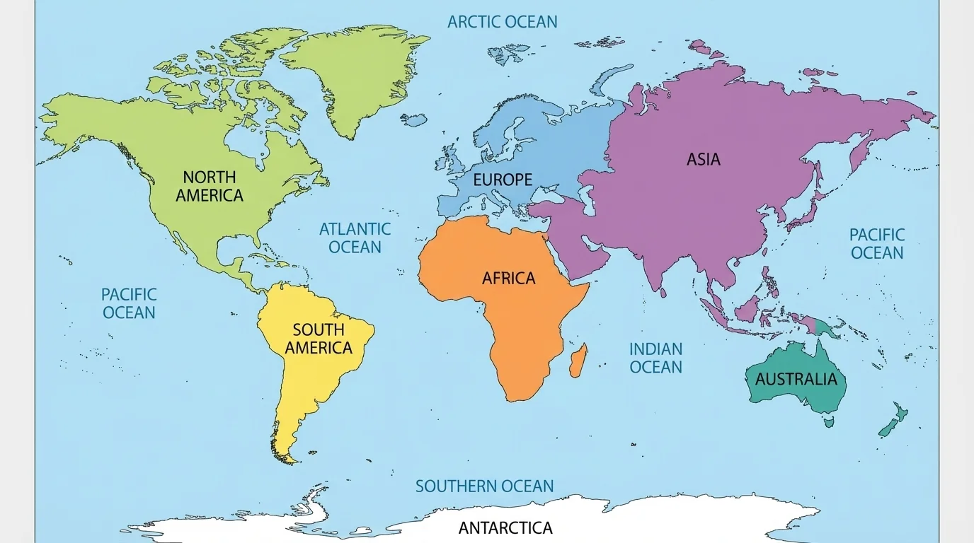
A useful pattern helps us remember locations. The Pacific Ocean is west of North and South America and east of Asia and Australia. The Atlantic Ocean is east of the Americas and west of Europe and Africa. Africa sits south of Europe. South America is southeast of North America. These direction clues make a world map easier to understand.
Maps of the world also help us notice that oceans connect places. Ships cross oceans, and airplanes fly over them. Continents are separated by water, but people on different continents still trade, travel, and communicate.
Earth has more water than land. That is one reason a globe or world map often looks mostly blue.
Later, when you look back at [Figure 1], you can use the continents and oceans as anchors. If you find North America first, you can then find the Pacific Ocean to its west and the Atlantic Ocean to its east.
A country is a nation with its own government and borders. On a political map, countries are often shown in different colors. Some major countries that are important to know on a world map are the United States, Canada, Mexico, Brazil, China, India, Russia, and Australia.
The United States is in North America. Canada is north of the United States, and Mexico is south of it. Brazil is in South America. China and India are in Asia. Russia stretches across Europe and Asia. Australia is both a country and a continent.
Maps also show smaller water features. A body of water is any area of water, such as an ocean, sea, gulf, river, or lake. Oceans are the largest. Rivers are long, moving bodies of fresh water. Lakes are inland bodies of water surrounded by land.
Here are some important examples. The Mississippi River is a major river in the United States. The Nile River is in Africa. The Great Lakes are between the United States and Canada. The Gulf of Mexico is south of the United States. A sea, such as the Mediterranean Sea, is smaller than an ocean and is partly enclosed by land.
| Type of place | Example | Where it is |
|---|---|---|
| Country | United States | North America |
| Country | Brazil | South America |
| River | Mississippi River | United States |
| Lake | Lake Superior | Part of the Great Lakes |
| Gulf | Gulf of Mexico | South of the United States |
| Sea | Mediterranean Sea | Between Europe and Africa |
Table 1. Examples of countries and bodies of water and where they are located.
When you read a map, notice whether labels are written across land or across water. Rivers may look like long blue lines. Lakes often look like blue shapes inside land. These visual clues help you quickly tell one kind of place from another.
Not all land is flat. Earth has hills, plains, valleys, plateaus, and mountains. A mountain range is a chain of mountains connected together. One of the most important mountain ranges for Colorado is the Rocky Mountains, which stretch through western North America.
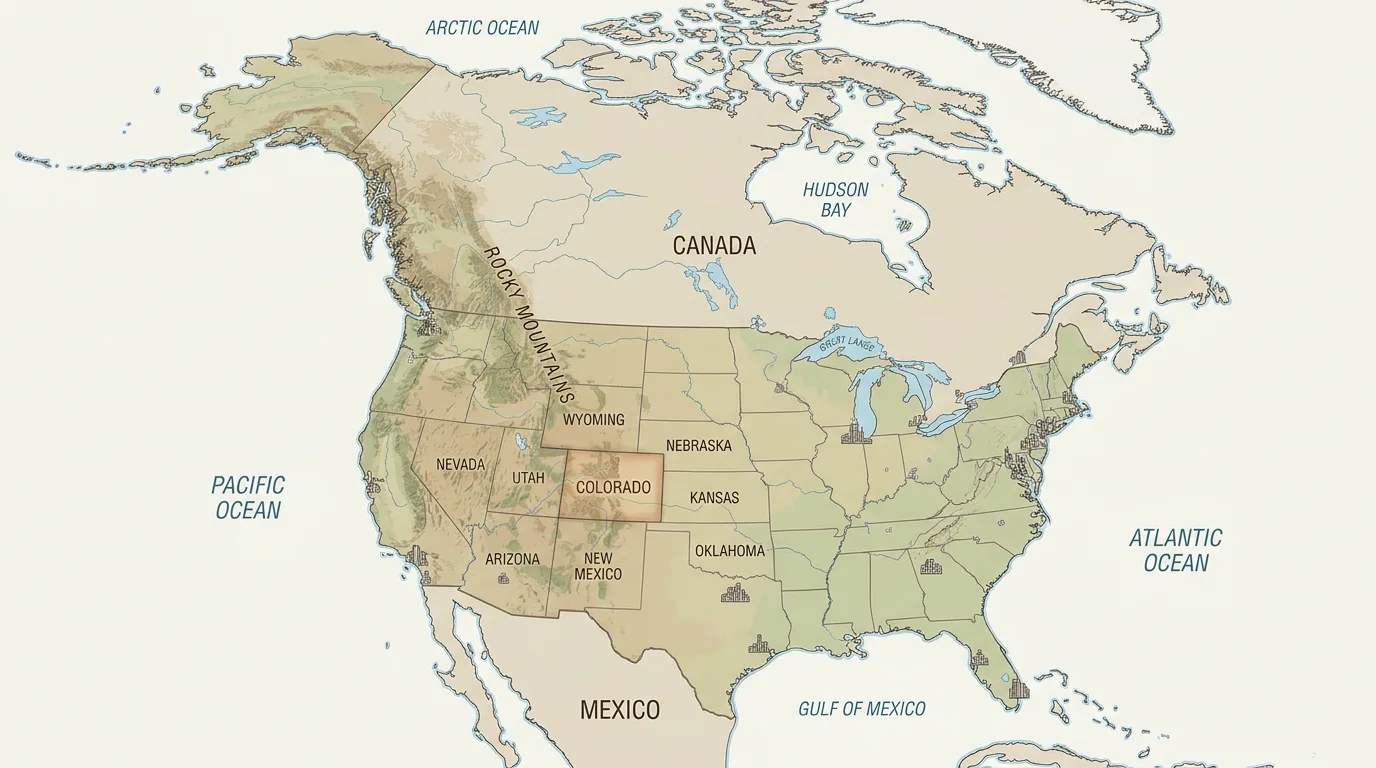
[Figure 2] On a physical map, mountains are often shown with brown colors, shaded relief, or raised-looking shapes. Flat lands may be green or yellow. Water is usually blue. These colors make it easier to compare the land.
The Rocky Mountains run from Canada through the United States. They pass through Colorado, so Colorado has many high mountain areas. Mountains affect weather, plants, animals, travel, and where people live. Roads may go around mountains or through passes between them.
Other major mountain systems in the world include the Andes in South America, the Himalayas in Asia, and the Alps in Europe. The Himalayas include Mount Everest, the tallest mountain above sea level on Earth.
When you compare world maps and physical maps, you can see how mountains shape human life. Big mountain ranges can separate regions. They can also attract visitors who come to hike, ski, or enjoy the scenery. Colorado is well known for this because of the Rockies we saw in [Figure 2].
How landforms affect people
Landforms are natural features of Earth's surface. Mountains can make travel harder but also provide water from snowmelt. Plains make it easier to farm and build roads. Rivers help cities grow because people need water and transportation routes.
Learning to notice landforms on maps helps you understand why some places have busy cities, farms, or parks. The shape of the land matters.
An urban area is a place where many people live and work close together. Urban areas usually include cities, roads, schools, stores, and neighborhoods. On many maps, cities are marked with dots, stars, or larger printed names.
Large urban areas are important because they are centers of government, business, transportation, and culture. For example, New York City, Los Angeles, and Chicago are major urban areas in the United States. Around the world, cities like Tokyo, London, and Mexico City are also major urban areas.
Maps often use different symbol sizes to show different city sizes. A capital city may be marked with a star. A very large city may be shown with a larger dot than a small town. Reading these symbols helps you understand where people are concentrated.
Reading a city symbol on a map
Step 1: Look at the map key.
The key may show that a star means a capital city and a dot means another city.
Step 2: Find the symbol on the map.
If you see a star by Denver, that tells you Denver is a capital city.
Step 3: Read the label.
The printed name tells you which city the symbol represents.
Map symbols help you find urban areas quickly and correctly.
Colorado has urban areas too. Denver is the largest city in Colorado and the state capital. Colorado Springs, Aurora, Fort Collins, and Pueblo are other important cities in the state.
Colorado is one of the states in the United States. On a U.S. map, Colorado is in the western half of the country, but it is not on the Pacific coast. It is also part of the interior of the United States, meaning it is inland and not next to an ocean.
Colorado is often easy to spot because its borders form a shape that is almost a rectangle. It is known for mountain areas in the west and central parts of the state and plains in the east. The capital city is Denver.
Colorado is important in map study because it includes more than one kind of landform. The eastern plains are flatter and are used for farming and ranching. The Rocky Mountains cross the state and create high elevations, snowy peaks, forests, and valleys.
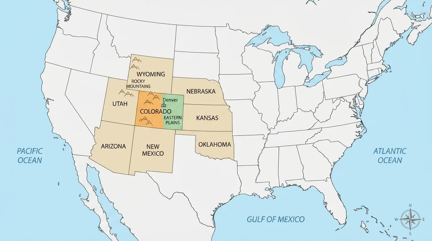
A student reading a map of Colorado should be able to locate Denver, recognize the mountains in the west, and notice that the state sits between other western and central states. This helps connect a state map to a larger U.S. map.
Colorado is also part of a region of the country where elevation changes greatly. In some places the land rises high into mountains, while in other places it stretches across wide plains. Looking again at [Figure 3], you can see why one state can include very different landscapes.
North, south, east, and west are useful every time you read a state map. If a place is north of Denver, it is above Denver on most maps. If it is west of Denver, it is to the left on most maps.
Map readers use these direction words all the time. They help describe location clearly and quickly.
Colorado touches seven other states. A close-up map helps us see each border clearly. Knowing neighboring states helps students understand relative location, which means where one place is compared with another place.
[Figure 4] The states that border Colorado are Wyoming to the north, Nebraska to the northeast, Kansas to the east, Oklahoma to the southeast, New Mexico to the south, Arizona at one small corner in the southwest, and Utah to the west.
Colorado is special because it is one of the states that touches the Four Corners area. Four Corners is the only place in the United States where four states meet at one point: Colorado, Utah, Arizona, and New Mexico.
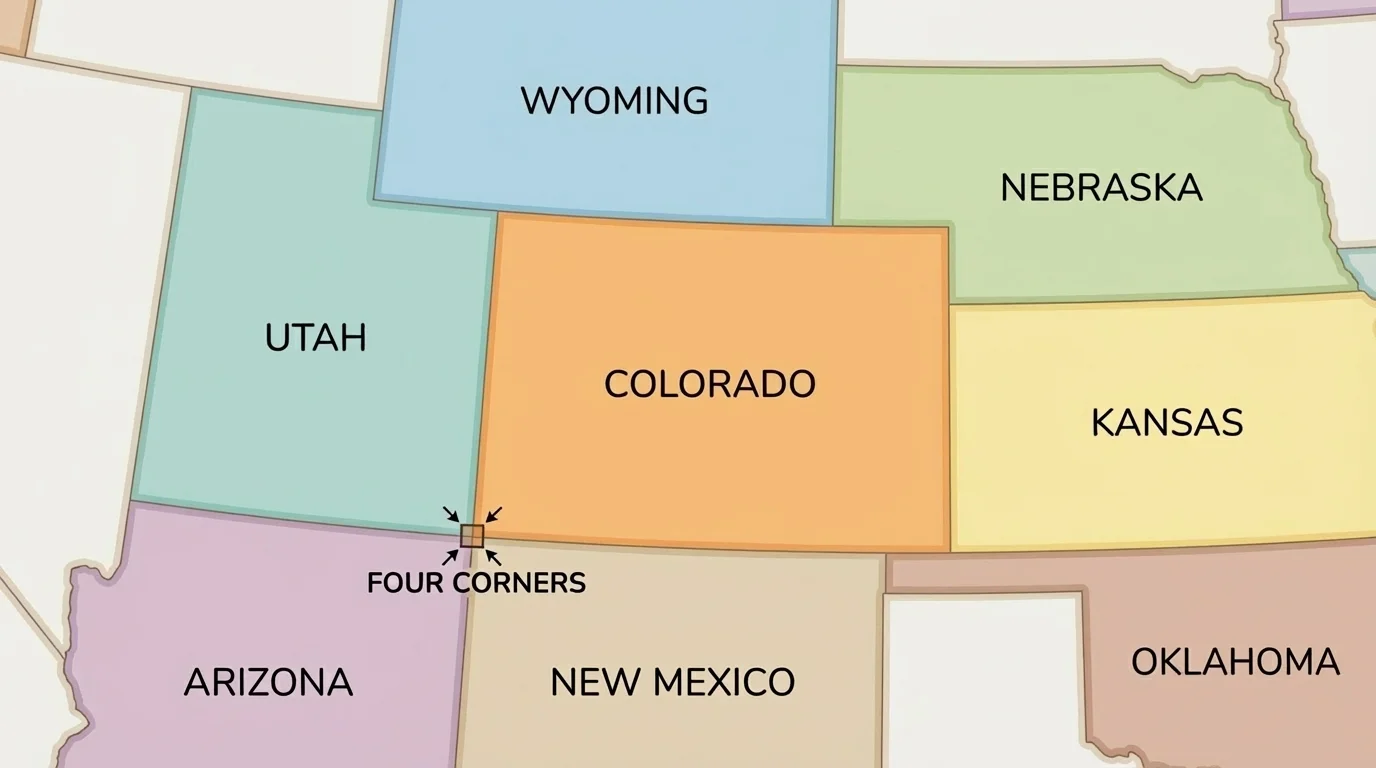
Students sometimes forget Arizona because Colorado and Arizona meet only at a corner, not along a long side. That tiny point still counts as neighboring. This is an important detail in map reading.
When you return to [Figure 4], trace the states around Colorado in a circle. Starting at the top with Wyoming and moving clockwise helps many learners remember the order.
| Direction from Colorado | Neighboring state |
|---|---|
| North | Wyoming |
| Northeast | Nebraska |
| East | Kansas |
| Southeast | Oklahoma |
| South | New Mexico |
| Southwest corner | Arizona |
| West | Utah |
Table 2. The neighboring states of Colorado and their directions.
Strong map readers use many clues at once. First, read the title to learn what kind of map it is. Next, check the compass rose for direction. Then use the key to understand symbols and colors. After that, read labels carefully. Finally, compare the places to each other: which one is north, south, east, west, inland, coastal, mountainous, or urban?
For example, if you are looking at a map of the United States, you can find Colorado in the western interior. Then you can see that Utah is west of Colorado and Kansas is east of Colorado. On a world map, you can locate North America and then identify the Atlantic Ocean to its east. This is how map tools and spatial thinking work together.
Maps are useful in everyday life. Weather maps show where storms are moving. Road maps and phone maps help families travel. Park maps help visitors find trails, lakes, and picnic areas. Pilots, truck drivers, hikers, and scientists all depend on maps.
When students learn to locate continents, oceans, countries, bodies of water, mountain ranges, urban areas, Colorado, and Colorado's neighboring states, they are building a picture of how Earth is organized. That picture helps them make sense of places near home and far away.