A place on Earth can be rainy almost every afternoon, while another place at the same latitude can be dry for most of the year. Coastal cities can stay mild, while inland places swing from hot to cold. These patterns are not random. They happen because Earth works like a set of connected systems, and scientists use models to understand how energy and matter move through those systems.
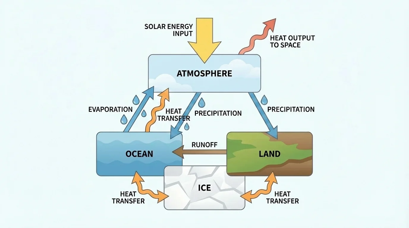
A system is a group of parts that interact with one another. In science, a system can be as small as a puddle or as large as the whole planet. When scientists study Earth, they often look at connected parts such as the atmosphere, oceans, land, and ice. A model helps organize these parts and their relationships, as [Figure 1] shows with arrows that trace what goes in, what happens inside, and what comes out.
Every system has inputs, processes, and outputs. An input is something that enters the system. A process is what changes or moves things inside the system. An output is something that leaves the system. For Earth, sunlight is a major input of energy. Heating, evaporation, wind, and ocean circulation are processes. Heat radiated back into space is an output.
Systems also have boundaries. A boundary is the edge scientists choose for what they are studying. For example, if the system is the Atlantic Ocean, the atmosphere above it may still matter because wind transfers energy to the water. Scientists choose boundaries so they can focus on important interactions without getting lost in too much detail.
System means a set of interacting parts.
Input is energy or matter entering a system.
Process is an action or change inside the system.
Output is energy or matter leaving the system.
Interaction is the way one part of a system affects another part.
Earth is really a set of connected systems, often called the atmosphere, hydrosphere, geosphere, and cryosphere. The atmosphere is the layer of gases around Earth. The hydrosphere includes water in oceans, rivers, lakes, and clouds. The geosphere is the solid Earth. The cryosphere includes ice, snow, and glaciers. A change in one part can affect the others. That is why system models are so useful.
Scientists cannot shrink Earth into a classroom object, and they cannot experiment with the whole planet in a lab. Instead, they use models. Some models are physical, like a globe or a stream table. Some are diagrammatic models that use arrows and labels. Some are computer models that calculate many changes over time.
A good model does not copy every tiny detail. Instead, it highlights the most important relationships. A weather map leaves out countless details from each street and building, but it still helps predict where storms may move. In the same way, a climate model focuses on key patterns such as sunlight, temperature, wind, ocean currents, and moisture.
Models have strengths and limits. They help scientists test ideas, compare patterns, and make predictions. But a model is always simpler than the real world. If a model leaves out an important factor, its prediction may be less accurate. Scientists improve models by comparing predictions with real observations.
Modern weather forecasts depend on giant computer models that process huge amounts of data from satellites, balloons, ships, and weather stations. Even with all that data, forecasts still change because Earth's systems are complex and always interacting.
As seen earlier in [Figure 1], one of the most useful parts of a system model is the arrows. Arrows can show movement of energy, movement of matter, or a cause-and-effect relationship. When students learn to read arrows carefully, system diagrams become much easier to understand.
Earth systems involve both energy flow and matter flow. Energy moves through a system and often changes form. Matter moves too, but unlike energy from the Sun, matter is recycled again and again inside Earth systems. Water, air, and dissolved substances travel through the atmosphere, oceans, land, and living things.
The main source of Earth's surface energy is the Sun. Solar energy warms land and water. That heating can cause evaporation, which turns liquid water into water vapor. Water vapor later condenses into clouds and may return as rain or snow. In this example, energy from sunlight drives the movement of matter, especially \(\textrm{H}_2\textrm{O}\), through the water cycle.
Energy can be transferred in several ways. Radiation transfers energy by electromagnetic waves, such as sunlight. Conduction transfers energy through direct contact. Convection transfers energy by movement in fluids such as air and water. Warm air rises and cool air sinks, creating convection currents. Warm water and cold water can do the same.
Energy is conserved, but it can spread out
When sunlight warms Earth, the energy does not disappear. It is transferred, stored for a time, and eventually released. For example, ocean water can absorb energy during the day and release some of it later. This is one reason coastal places often change temperature more slowly than inland places.
Scientists sometimes describe energy transfer with the relationship \(Q = mc\Delta T\), where \(Q\) is thermal energy transferred, \(m\) is mass, \(c\) is specific heat, and \(\Delta T\) is change in temperature. If \(2 \textrm{ kg}\) of water with \(c = 4{,}180 \textrm{ J/(kg\cdot{}^\circ C)}\) warms by \(3^\circ \textrm{C}\), then \(Q = 2 \cdot 4{,}180 \cdot 3 = 25{,}080 \textrm{ J}\). This example helps explain why water, with its high specific heat, changes temperature more slowly than many land surfaces.
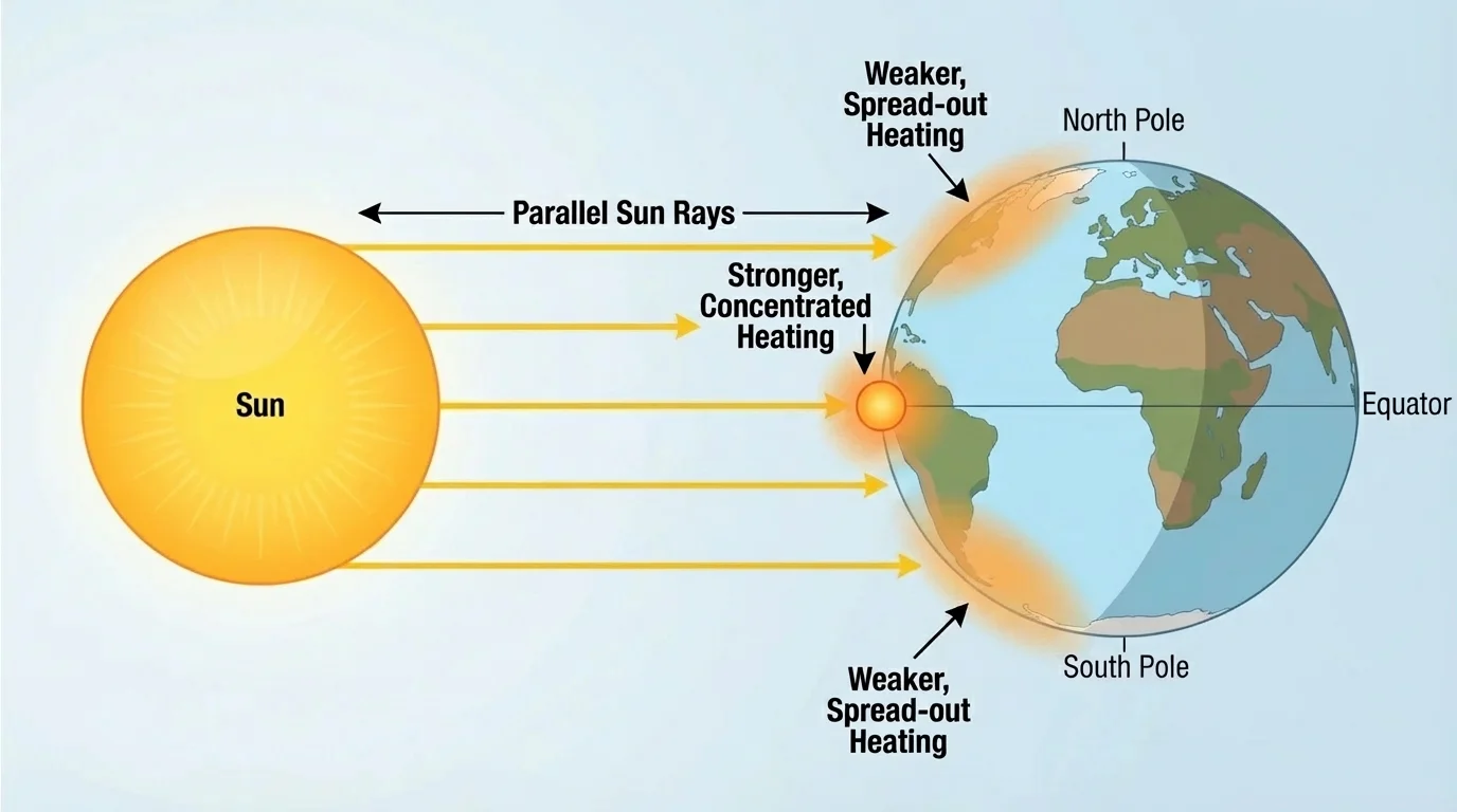
One of the biggest ideas in Earth science is unequal heating. Earth does not heat evenly. Sunlight strikes near the equator more directly, while sunlight near the poles arrives at a lower angle and spreads over a larger area.
[Figure 2] Think about a flashlight. If you shine it straight onto a wall, the light is bright and concentrated. If you tilt the flashlight, the same light spreads over a larger area and becomes less intense. Sunlight works in a similar way. Near the equator, more energy reaches each square meter of surface. Near the poles, the same incoming sunlight is spread out more.
Unequal heating also happens because land and water heat differently. Land usually warms and cools faster than water. Water has a high specific heat, so it takes more energy to change its temperature. This difference affects sea breezes, monsoons, and coastal climates.
Surface color and texture matter too. Dark surfaces usually absorb more sunlight, while lighter surfaces reflect more. Ice and snow reflect a large amount of incoming sunlight. Forests, deserts, oceans, and cities can all respond differently to the same sunlight.
Real-world example: Why beaches often feel cooler in the afternoon
A sandy beach and the nearby ocean receive sunlight during the day, but they do not heat at the same rate.
Step 1: The land heats quickly because it has a lower specific heat than water.
Step 2: Air above the land becomes warmer and rises.
Step 3: Cooler air from above the water moves inland to replace it.
Step 4: This moving air creates a sea breeze that helps cool the shore.
This small local system uses the same ideas as larger Earth systems: unequal heating creates movement.
Later, the same idea helps explain global wind belts. The uneven heating seen in [Figure 2] starts the motion of air that eventually shapes climate patterns around the world.
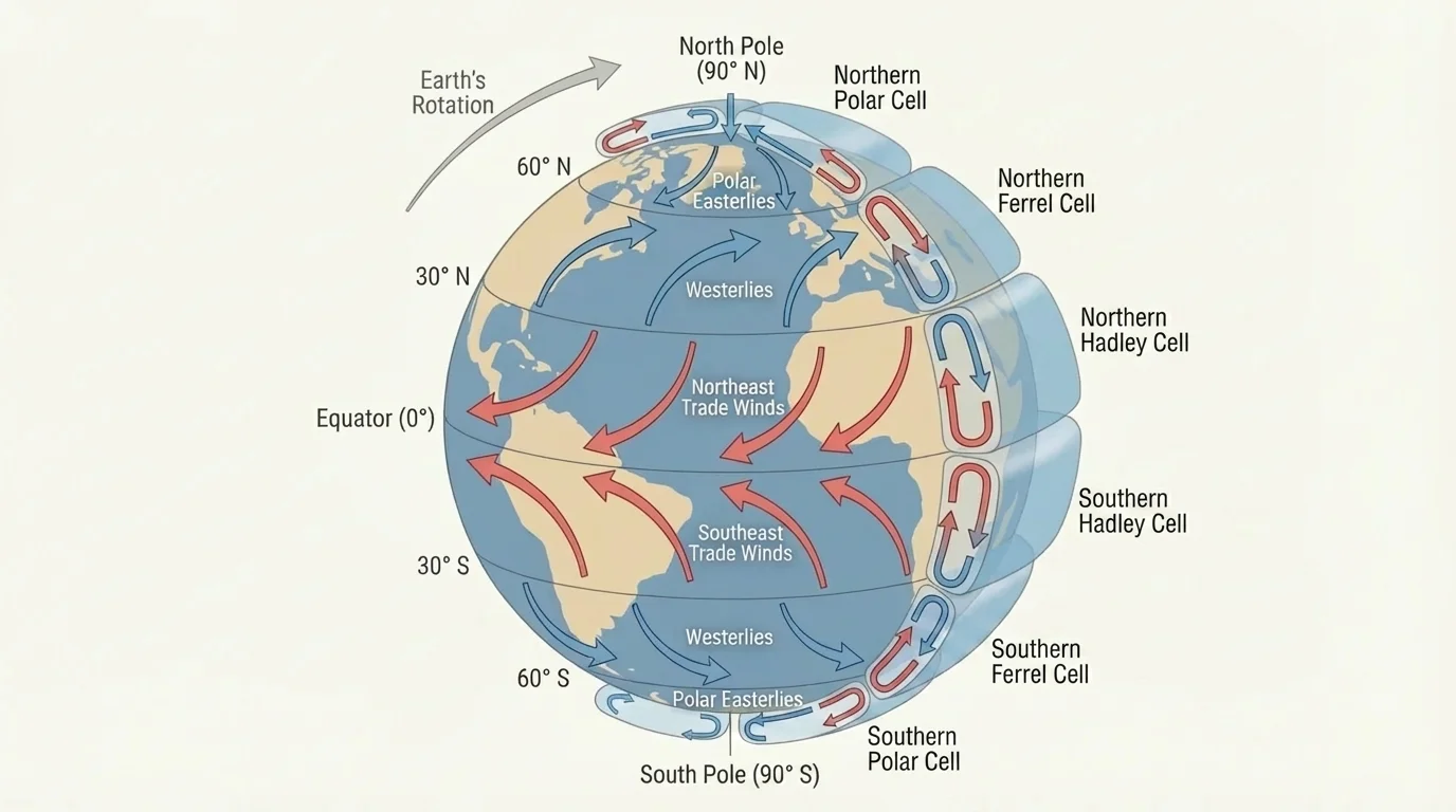
Heating alone does not explain the pattern of winds and currents. Earth is also spinning. This rotation changes the path of moving air and water. In the Northern Hemisphere, moving air and water tend to curve to the right. In the Southern Hemisphere, they tend to curve to the left. This apparent turning is called the Coriolis effect, and [Figure 3] shows how it helps create global circulation patterns.
Warm air rises near the equator because that region receives intense solar heating. As the air rises, it cools and later sinks at higher latitudes. This movement forms large convection cells in the atmosphere. Because Earth rotates, the moving air does not travel in perfectly straight north-south paths.
The result is a pattern of major wind belts. Near the equator, surface winds called trade winds blow toward the equator and curve westward. In the middle latitudes, westerlies blow from west to east. Near the poles, polar easterlies blow from east to west.
These wind belts matter because they move heat and moisture around the planet. They also help drive surface ocean currents by pushing on the ocean surface. So the atmosphere and ocean are closely linked systems, not separate ones.
Warm fluids tend to rise and cool fluids tend to sink. Air and water are both fluids, so convection can happen in both. Earth's rotation then changes the direction of that movement on a global scale.
If Earth did not rotate, large-scale circulation would be simpler. Air would still rise in warm regions and sink in cool regions, but the belts and curved paths would look very different. Rotation makes the global pattern more complex and more realistic.
Atmospheric circulation is the large-scale movement of air through Earth's atmosphere. It helps balance temperature differences between warm and cool regions. Without it, the equator would become much hotter and the poles much colder than they already are.
Rising air often leads to clouds and precipitation because as air rises, it cools and water vapor can condense. Sinking air usually becomes warmer and drier. This pattern helps explain why some regions are wet while others are dry.
Near the equator, warm moist air rises often, leading to frequent rainfall in many tropical regions. Around \(30^\circ\) north and south, air often sinks, creating drier conditions. Many major deserts are found near these latitudes. This is not an accident; it is a system pattern caused by circulation.
Prevailing winds also affect where moisture goes. If winds blow from ocean to land, coastal areas may get more moisture. If mountains force moist air upward, one side of the mountain may be wet while the other side is dry. This is called a rain shadow.
Case study: Why some west coasts are dry
In some regions, global wind patterns and ocean currents combine to reduce rainfall.
Step 1: Air circulation causes dry, sinking air near \(30^\circ\) latitude.
Step 2: A cold ocean current cools the air above it, limiting evaporation.
Step 3: With less moisture added to the air, clouds and rainfall are reduced.
This combination helps explain dry coastal climates in parts of western South America and southwestern Africa.
As the wind belts in [Figure 3] make clear, the path of moving air influences where heat and water vapor are carried. Climate is not just about temperature; it is about energy and matter moving through a system over time.
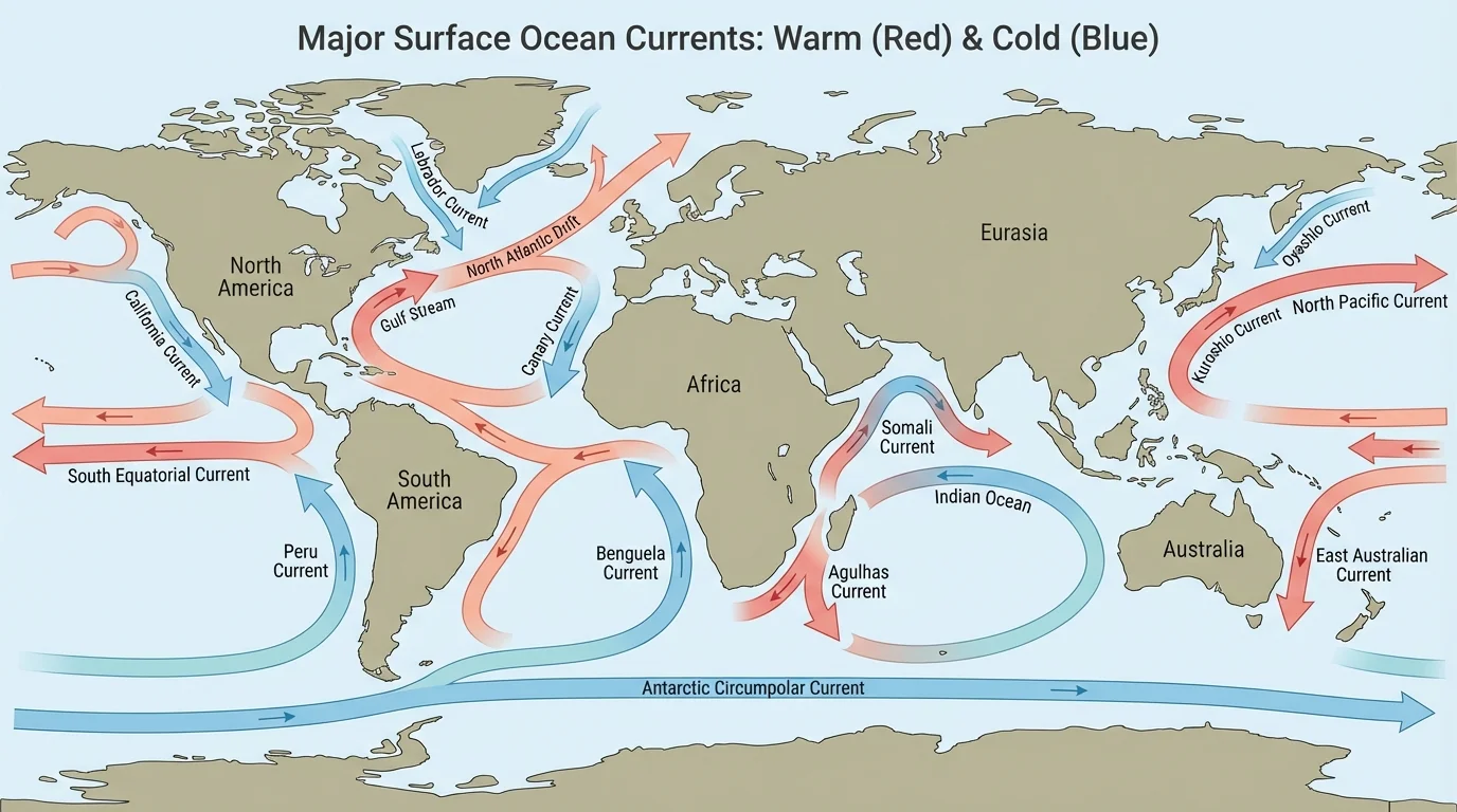
The ocean is not still water. It moves in large patterns called ocean currents, and [Figure 4] shows that these currents transport heat from one region to another. Surface currents are mainly driven by wind, while deep currents are driven by differences in temperature and salinity.
Warm currents can make nearby land warmer and wetter. Cold currents can make nearby land cooler and sometimes drier. For example, a warm current flowing along a coast can keep winters milder than expected for that latitude. A cold current can cool coastal air and sometimes increase fog.
Deep ocean circulation is often called the global conveyor belt. In polar regions, very cold, salty water becomes dense and sinks. That water then moves through the deep ocean and eventually rises elsewhere. This slow movement helps mix the ocean and distribute energy and matter around the world.
Ocean circulation also moves matter such as dissolved oxygen, nutrients, and \(\textrm{CO}_2\). This matters for marine life and for climate. When oceans absorb energy and gases from the atmosphere, they influence conditions far beyond the shore.
Why coasts and interiors differ
Large bodies of water heat and cool more slowly than land. Because of this, coastal climates are often milder, with smaller temperature changes over the year. Interior regions, far from the ocean's influence, usually have bigger seasonal changes.
A place near a warm current may have a climate very different from another place at the same latitude. The map of ocean currents in [Figure 4] helps explain why latitude alone cannot predict climate.
When you read a system model, start by identifying the parts. What are the major components? Next, look for the inputs. In Earth climate models, solar energy is a major input. Then identify the processes, such as heating, evaporation, convection, wind, and current formation. Finally, look for outputs, such as heat leaving Earth to space or water leaving a local area as runoff.
After that, trace the arrows. Ask what is moving: energy, matter, or both. If sunlight warms the ocean, that is energy transfer. If water evaporates from the ocean into the air, that is matter transfer. If wind pushes the water surface, that is an interaction between systems.
Some models also show feedback. A feedback happens when a change in one part of a system affects the system again. For example, if warming melts ice, darker ocean water is exposed. Darker water absorbs more sunlight than bright ice, which can lead to more warming. This is a positive feedback because it increases the original change.
How to trace a climate system model
Suppose a model shows sunlight, ocean water, evaporation, clouds, rainfall, and rivers.
Step 1: Identify the input: sunlight enters the system.
Step 2: Follow the process: sunlight warms ocean water, and some water evaporates.
Step 3: Track matter flow: water vapor moves into the atmosphere, forms clouds, and falls as rain.
Step 4: Find outputs or transfers: river water returns to the ocean, and heat is transferred back to the atmosphere and space.
This kind of tracing turns a diagram into a story of cause and effect.
Reading models carefully helps students think like scientists. Instead of memorizing isolated facts, they learn to connect processes and predict what might happen if one part changes.
System models are used every day. Weather forecasts depend on models of moving air, temperature, moisture, and pressure. Ocean models help ships plan safer and faster routes. Farmers use seasonal climate forecasts to decide when to plant crops. Emergency planners use hurricane and flood models to prepare communities.
Scientists also use models to study long-term climate change. They test how changing amounts of gases such as \(\textrm{CO}_2\) may affect temperature, ice cover, precipitation, and ocean circulation. These models are not guesses. They are built from observed data, physical laws, and repeated testing.
Even in everyday life, people rely on ideas from system models. A surfer checks wind and current forecasts. A pilot studies jet stream patterns. A city planner considers flood risk and stormwater flow. A fishing fleet watches ocean temperature patterns because fish populations often move with changing water conditions.
"The whole is greater than the sum of its parts."
— A useful principle for studying systems
The big idea is that Earth's climate is not controlled by just one thing. It comes from interactions among sunlight, land, water, air, ice, and motion. Models make those interactions visible and understandable.