Have you ever looked at a map and found your school, a park, or a road you know? A map may look like a simple drawing, but it is really a tool packed with clues. Geographers use these clues to learn where things are, how places are connected, and why people live, travel, and build in certain areas. When you know how to read geographic tools, you can learn a lot about the world without even leaving your seat.
Geography is the study of places and how people and nature fit together in those places. To study geography, we use tools that help us see location and space. These tools can help us find a river, compare two states, follow a road, or notice where mountains and cities are located.
When we study where things are, we are using spatial thinking. Spatial thinking means thinking about the position of places, the distance between them, and the patterns they make. For example, if many towns are built near water, that pattern tells us something important. Maybe people need water for drinking, farming, or travel.
You already know that places can be described by words like near, far, north, and south. Geographic tools help make those ideas more exact and easier to understand.
Geographic tools are useful in everyday life. Families use maps to drive somewhere new. Meteorologists use weather maps to study storms. Pilots use maps and globes to plan trips. Even when you play a treasure hunt game, you are using location clues just like a geographer.
A geographic tool is something that helps us learn about Earth and places on Earth. One common tool is a map, which is a drawing of all or part of Earth. Another important tool is a globe, which is a round model of Earth. Maps and globes help us study places in different ways.
A map has important parts that help us read it correctly, as [Figure 1] shows. A title tells what the map is about. A legend explains what the symbols mean. A symbol stands for something on the map, such as a school, road, or river. A compass rose shows directions like north, south, east, and west. A scale helps us understand distance.
If a map has a picture of a tree, that symbol might mean a forest. If it has a blue line, that might mean a river. Without the legend, we might guess wrong. That is why good map readers always check the legend before making conclusions.
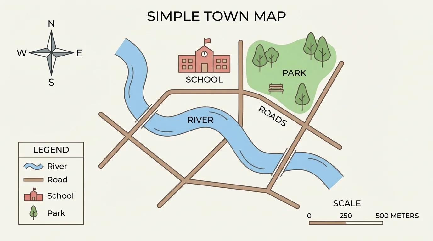
Map parts work together to give information. The title tells the topic, the legend explains symbols, the compass rose shows direction, and the scale helps estimate distance.
A globe is different from a flat map because it shows Earth as round. That means a globe can help us understand the shape of continents and oceans more accurately. However, a globe cannot show as many small details as a large map can. That is why geographers use both maps and globes.
Reading a map is like solving a puzzle with clues. First, look at the title. The title tells you what place or topic the map shows. A map called Parks in Our Town gives different information from a map called Roads in Our Town.
Next, look at the legend. The legend helps you match symbols to real features. A black line might mean a road. A blue shape might mean a lake. A red star might mean the state capital. When we understand the symbols, we can read the map more carefully.
Then, use the compass rose to find direction. If the library is east of the school, it is to the right on many maps, though not always. The compass rose is important because not every map is turned the same way. Good readers do not assume. They check directions.
After that, use the scale. A map is smaller than the real place it shows, so the scale tells how map distance matches real distance. For example, if a scale says one small section equals one mile, then two of those sections would equal two miles, or in math, if one section represents \(1\) mile, then \(2\) sections equal \(2\) miles.
Reading a town map
A student looks at a town map to find the park.
Step 1: Read the title.
The title says Map of Green Town, so the map is about that town.
Step 2: Check the legend.
The legend shows that a green square means a park.
Step 3: Use the compass rose.
The park is west of the school, so it is on the left side of the school on this map.
Step 4: Use the scale.
If the park is \(2\) scale units from the school, and each unit equals \(1\) mile, then the distance is \(2\) miles.
The map helps the student find both the location and the distance.
As we saw earlier in [Figure 1], each map part gives a different clue. If you skip one part, you may miss important information.
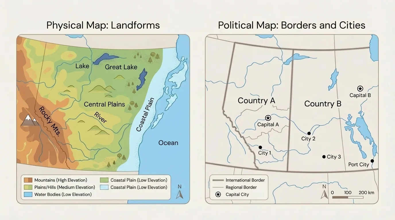
Different tools show different kinds of information, and [Figure 2] makes this easy to compare. A physical map shows natural features such as mountains, rivers, deserts, and plains. A political map shows borders, countries, states, and cities.
If you want to know where the Rocky Mountains are, a physical map is helpful. If you want to know where Nebraska is or where a state border runs, a political map is helpful. The same place can look very different depending on the kind of map you use.
A weather map is another geographic tool. It can show clouds, rain, snow, wind, or temperature. A road map shows highways and streets. A globe shows the whole Earth. Each tool answers a different kind of question.
| Tool | What It Shows | Question It Can Help Answer |
|---|---|---|
| Map | Places on a flat surface | Where is the park in town? |
| Globe | The round Earth | Where is Africa compared with South America? |
| Physical map | Land and water features | Where are mountains or rivers? |
| Political map | Borders and cities | Which state is next to Iowa? |
| Weather map | Weather conditions | Where is it raining today? |
Table 1. Different geographic tools and the kinds of questions they can answer.
When geographers choose a tool, they think about the information they need. A tool is useful when it matches the question being asked.
Some world maps can make places near the poles look bigger than they really are. That is one reason globes are helpful when studying the true shape of Earth.
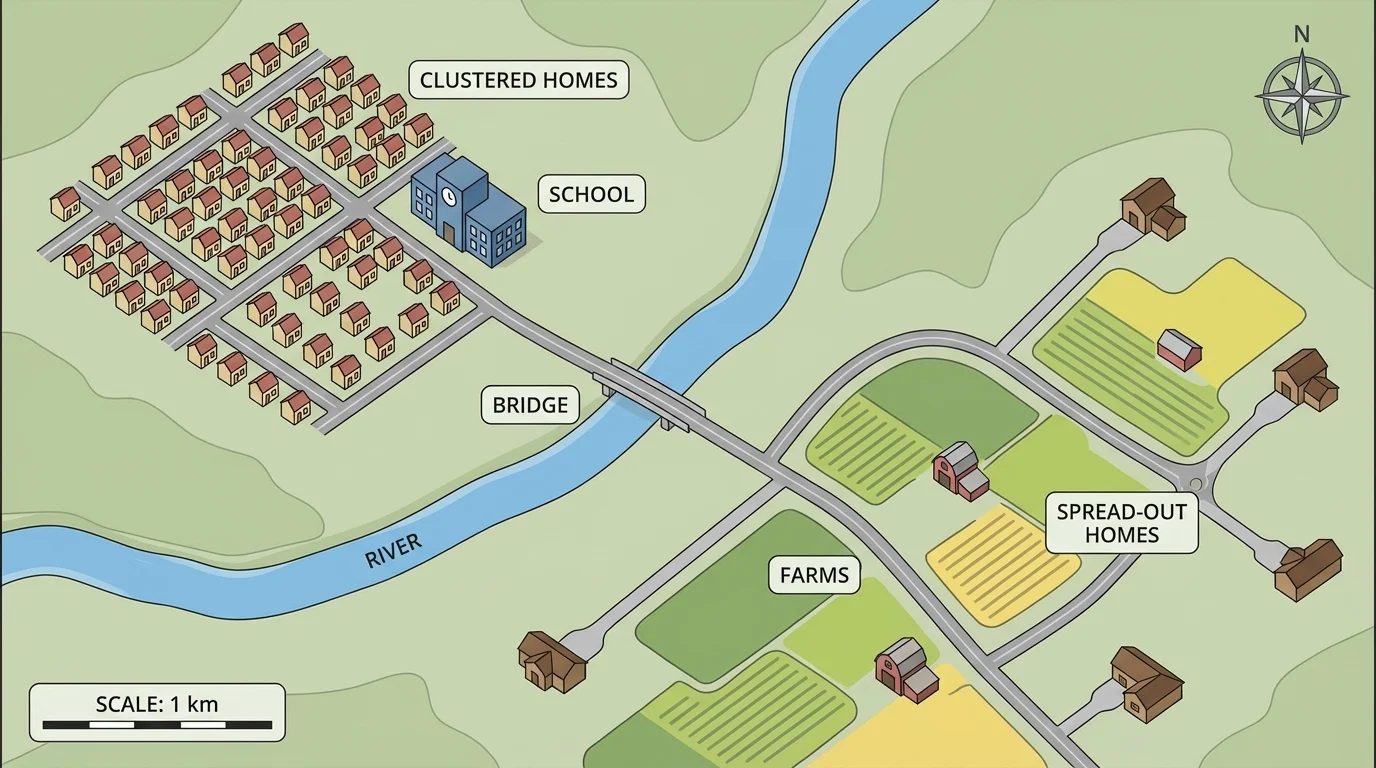
Geographers do more than name places. They look for patterns, and [Figure 3] illustrates how a map can reveal where places are grouped together or spread apart. A pattern is something we notice happening in a regular way. For example, many homes may be near roads, while farms may be farther apart.
Patterns help us think about location. Location means where something is. We can describe a place by saying it is north of a river, near a bridge, or far from the city center. We can also compare locations. One town may be closer to a lake than another town.
Patterns also help us think about why places are arranged the way they are. A school may be built near homes so children can get there more easily. Farms may be outside the busiest parts of town because they need more open land. Rivers often have bridges at narrow crossing points. These are geographic concepts because they connect place and human activity.
Using spatial thinking means looking at where things are, how close or far apart they are, and what patterns you notice. Then you use those patterns to make sense of how people and nature use space.
Suppose a map shows many stores near a highway. That pattern may tell us the highway helps people travel to those stores. If a map shows towns near a river, the river may provide water or transportation. Maps can help us move from simply seeing a place to understanding it.
Later, when you ask questions about a map, the pattern in [Figure 3] helps you notice details such as why homes cluster near the bridge while farms spread farther away.
A strong geographer does not just read information. A strong geographer asks questions about what the tool shows. Geographic questions usually focus on place, direction, distance, patterns, and reasons.
[Figure 4] Good question starters include: Where is it? What is nearby? How far is it? What is north of it? Why might it be there? These questions turn a map into a source of information.
Here are some examples of geographic questions: Where is the river compared with the school? Which road leads to the park? What is east of the library? Why are many houses close to the main road? Which town is closer to the lake?
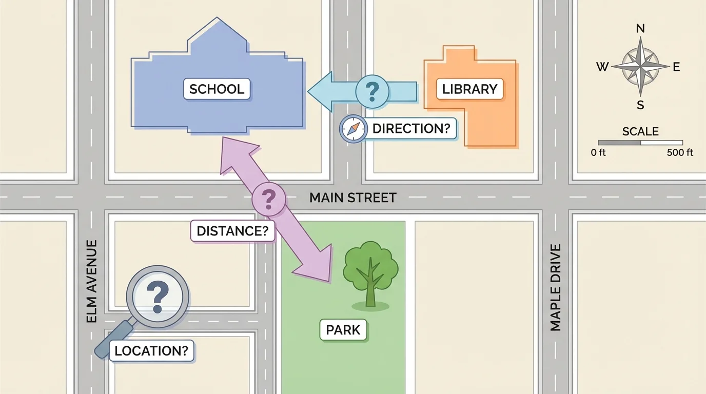
Turning observations into questions
A map shows a school, a library, a park, and a river.
Step 1: Notice something on the map.
The park is next to the river.
Step 2: Turn the observation into a location question.
Where is the park in relation to the river?
Step 3: Ask a pattern question.
Why might the park be built near the river?
Step 4: Ask a direction question.
What is north of the park?
Questions help us dig deeper into the information a map gives.
Sometimes the answer is directly on the map. Sometimes the map gives clues, and we must think carefully. That is part of being a geographer.
Let us look at a few simple case studies. In a town map, we might see that the fire station is close to major roads. That location makes sense because firefighters need to travel quickly. A geographic question could be: Why is the fire station near the main road instead of at the edge of town?
[Figure 5] On a state map, we might notice that many cities are connected by highways. We can ask: Which city is west of another city? Which city is closer to the state capital? A political map helps answer these questions because it shows cities and borders clearly.
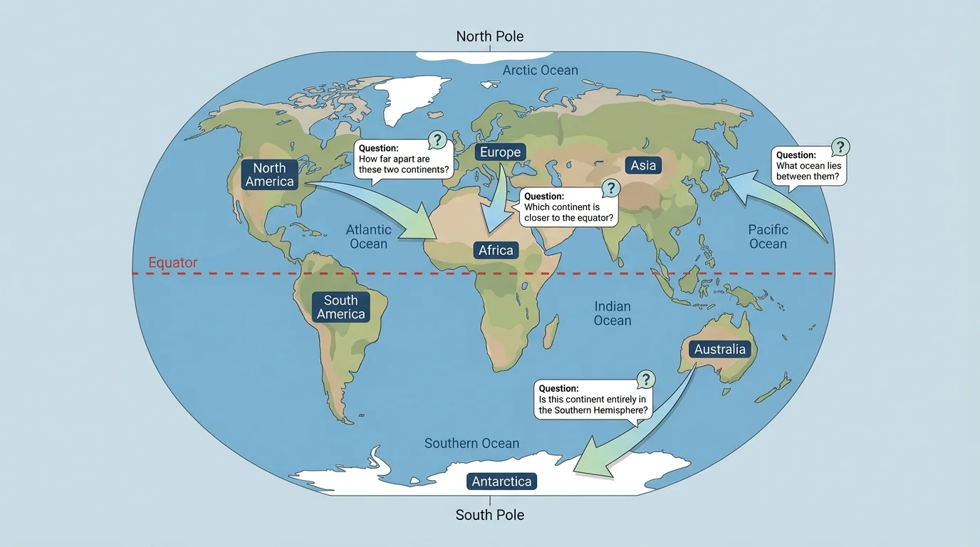
When we study the whole world, a globe is especially useful because it helps us see Earth as round. A globe can help us ask big questions such as: Which continent is south of Europe? Which ocean lies between Africa and Australia? Why do some places have long sea routes?
These case studies show that geographic tools can be used at different sizes. A neighborhood map covers a small area. A state map covers a larger area. A globe covers the whole planet. The size of the area we study changes the kind of question we ask.
Comparing tools for one question
Question: Which is better for finding your classroom building, a globe or a school map?
Step 1: Think about the size of the place.
A classroom building is a very small place.
Step 2: Think about the tool.
A globe shows the whole Earth, so it does not have enough detail for one building.
Step 3: Choose the better tool.
A school map is better because it shows small places in detail.
Geographers match the tool to the question.
As we also noticed with [Figure 2], not all maps give the same information. A careful reader chooses the tool that fits the job.
You do not have to be a scientist to use geography. Families use map apps to find restaurants, hospitals, and parks. Weather forecasters use weather maps to explain storms. Hikers use trail maps to stay on safe paths. Delivery drivers use maps to plan routes. All of these people read symbols, directions, and distance.
Geographic tools also help people make decisions. If a town wants to build a new playground, leaders might look at where children live. If farmers want to know where water is available, they may use maps showing rivers and land. If travelers want the shortest route, they study roads and distance.
The questions people ask may sound different, but they all connect to geography: Where is it? How do we get there? What is nearby? Why is this place important?
"Maps tell stories about places."
— Geographic idea
Sometimes students make mistakes when reading maps. One mistake is ignoring the title. Another is forgetting to check the legend. A third mistake is guessing direction without using the compass rose. These mistakes can lead to wrong answers.
Another common mistake is forgetting that maps are smaller than real places. That is why the scale matters. If two places look close on a map, they may still be far apart in real life. The scale helps us understand the true distance.
Careful readers also compare tools. If a globe and a map seem different, the reason may be that each tool is showing the world in a different way. Good geographers ask, compare, check details, and think about patterns before making conclusions.
By now, you can see that reading geographic tools is not just about naming places. It is about using clues from maps and globes to understand location, direction, distance, and patterns. It is also about asking smart questions that help you learn more about the world around you.