Have you ever noticed that a puddle, a tiny creek, and a huge ocean are all water, but they do not look the same at all? Earth is full of amazing patterns. Some places are high, like hills and mountains. Some places are low, like valleys. Water collects in some places and moves through others. Scientists look for these patterns so they can understand how our world is shaped.
When we want to study a place, we often use a model. A model is a smaller, simpler way to show something real. A globe is a model of Earth. A toy car is a model of a real car. A drawing of your neighborhood can be a model too. Models help us notice important parts without needing to look at every tiny detail.
A model helps us represent something in a way that is easier to see, build, or explain. Some models are flat, like maps. Some are three-dimensional, like clay landforms. A good model does not copy everything. Instead, it shows the parts we need to learn about.
Model means a representation of something real. It can be a drawing, a map, a diagram, or an object you build.
Pattern means something that repeats or appears in a predictable way. In nature, patterns can include the way rivers curve, the way land rises and falls, or the places where water collects.
Scientists use models because Earth is very big. It is hard to hold a mountain, a river, and a lake in your hands. But you can build a small version or draw a map of them. Then you can talk about what is high, what is low, and where the water goes.
One area can have many kinds of land and water, as [Figure 1] shows. A landform is a natural shape of the land. Some common landforms are hills, mountains, valleys, and plains. A hill is raised land. A mountain is very high, steep land. A valley is low land between higher places. A plain is wide, mostly flat land.
Earth also has many kinds of water areas. A body of water is a place where water is found. A pond is small and still. A lake is larger. A river moves from one place to another. An ocean is the biggest body of water. Streams are smaller than rivers, and they often flow into rivers.
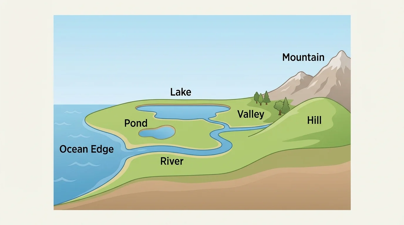
These landforms and bodies of water are not placed randomly. Water often moves from higher places to lower places. That is why streams and rivers often begin in hills or mountains and flow down through valleys. Lakes and ponds usually form where water collects in lower areas.
Some rivers are so winding that they look like giant snakes from above. Their curving paths are a natural pattern made by moving water.
If you walk around a park, you may see a small hill, a flat field, and a puddle in a lower spot after rain. That is a small example of the same Earth patterns we see in larger places.
Nature has many patterns we can notice. One pattern is high and low. Mountains and hills are high places. Valleys and basins are low places. Another pattern is flat and steep. A plain is flatter than a mountainside. These differences matter because they affect where water goes.
Another pattern is still water and moving water. Ponds and lakes usually stay in one place. Rivers and streams move. Flowing water often follows a path that bends and turns around the land. That is why rivers are often curvy instead of straight.
We can also notice the pattern of land next to water. Beaches are where land meets large water. Riverbanks are where land meets a river. The shape of the land can help decide the shape of the water, and the water can slowly change the shape of the land too.
Land and water fit together
Land and water are connected parts of Earth. High land can guide water downhill. Low land can collect water. Over time, moving water can cut into land, carry soil, and help make new shapes.
When you study an area, it helps to ask simple questions: Is this place high or low? Is the water still or moving? Is the land flat, rolling, or steep? These questions help you find patterns and make a better model.
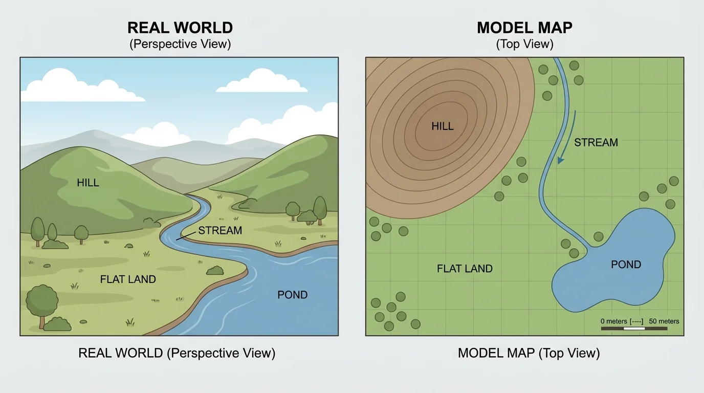
When we make a model of a place, we choose the most important features to include, as [Figure 2] illustrates. If an area has a hill, a pond, and a stream, those features belong in the model. Tiny things, like every blade of grass or every pebble, do not need to be included.
A model can be made from clay, paper, blocks, or a drawing. In a three-dimensional model, you can build a raised hill and a lower valley. In a map, you can use shapes and colors to show the same features. Green might show land, and blue might show water. Brown might show higher land.
Many maps show an area from above. This is called a bird's-eye view. It is like looking down from the sky. From above, it is easier to see where the river bends, where the lake sits, and how the land is arranged.
A strong model should match the real area in simple ways. If the hill is next to the river in real life, it should also be next to the river in the model. If the pond is smaller than a lake, the model should show that size difference too, even if it is only approximate.
Example: Modeling a schoolyard area
A class wants to model a small outdoor area with a grassy hill, a flat field, and a puddle that forms after rain.
Step 1: Identify the land and water features.
The grassy hill is a landform. The flat field is another land area. The puddle is a small body of water.
Step 2: Notice the pattern.
The puddle forms in the lower part of the area, not on top of the hill. This shows that water collects in lower places.
Step 3: Build or draw the model.
The model shows one raised part for the hill, one flat part for the field, and one low blue area for the puddle.
This model helps students explain why rainwater does not stay on the highest ground.
As we saw earlier in [Figure 1], one area can include several kinds of land and water at the same time. A model helps us put those pieces together clearly.
A map is a kind of model. It uses symbols, colors, and labels to represent real places. A blue line may stand for a river. A blue shape may stand for a lake. A brown or green shape may stand for land. A label tells the name of the place.
When you read a model, look at where things are. Is the river between hills? Is the pond near flat land? Is the valley lower than the mountain? A model helps you answer these questions without standing in the actual place.
Some models are simple and some are detailed. For young scientists, a simple model is often best. It should be easy to read and should show the main pattern of the area.
| Feature | What it is like | How a model may show it |
|---|---|---|
| Hill | Raised land | Small bump or rounded shape |
| Valley | Low land between higher places | Dip between two raised parts |
| River | Moving water | Long blue line |
| Lake | Larger still water | Wide blue shape |
| Pond | Small still water | Small blue shape |
| Plain | Mostly flat land | Flat green area |
Table 1. Common land and water features and simple ways to represent them in a model.
Reading maps and models is an important skill. People use it when they travel, build things, study weather, and learn about nature.
[Figure 3] Land does not always stay exactly the same. Water can slowly change it. Rain falls on hills and mountains. Then water flows downhill. As it moves, it can carry tiny pieces of soil or rock.
This wearing away of land is called erosion. Erosion can make a path in the soil. Over time, flowing water can make a small channel bigger. That is one reason streams and rivers have clear paths.
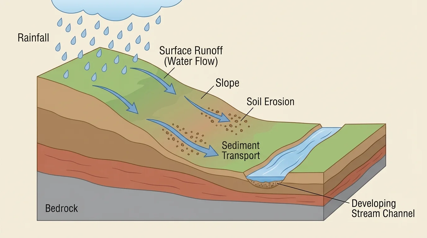
Water can also deposit, or drop, the soil it carries. When water slows down, some of the soil may settle in a new place. So water can both wear land away and build land up in different spots.
Water moves downhill because lower places collect it. This idea helps explain why rivers flow through valleys and why puddles form in dips in the ground.
Think about a sandbox after rain. You may see tiny paths where water ran through the sand. That is a small version of the same process that shapes parts of Earth over a long time.
Later, when you look again at [Figure 2], the top-view model makes it easier to predict where rainwater might travel. It will usually move from the higher parts toward the lower parts.
Models are not just for classrooms. Builders use land models to decide where roads and houses should go. Park workers use maps to plan trails. Emergency helpers use models and maps to understand where water may collect after heavy rain.
Farmers also care about the shape of land. On steep land, water may run off quickly. On flatter land, water may soak in or collect. Knowing the pattern of land and water helps people take care of soil and crops.
Real-world example: A safe playground
Adults planning a playground need to know where the ground is high and low.
Step 1: They study the area.
They notice a low spot where water gathers after rain.
Step 2: They use a model or map.
The model shows the low spot, the slope of the land, and nearby paths.
Step 3: They make a smart choice.
They avoid putting important equipment in the wettest area.
The model helps keep the space safer and more useful.
Even animals respond to land and water patterns. Fish live in water, birds may nest near ponds or rivers, and many plants grow best in certain places. Earth's shapes help living things find food, shelter, and water.
When we build and read models, we become better observers. We start to notice that Earth is full of connected parts: high land, low land, moving water, still water, and the patterns that tie them together.